Bridge Statistics for Mahanoy City, Pennsylvania (PA)
Condition, Traffic, Stress, Structural Evaluation, Project Costs
- National Bridge Inventory (NBI) Statistics
- 14Number of bridges
- 108ft / 32.8mTotal length
- $1,310,000Total costs
- 72,418Total average daily traffic
- 14,330Total average daily truck traffic
- National Bridge Inventory (NBI) Registered Bridges for Mahanoy City
- No street view available for this location
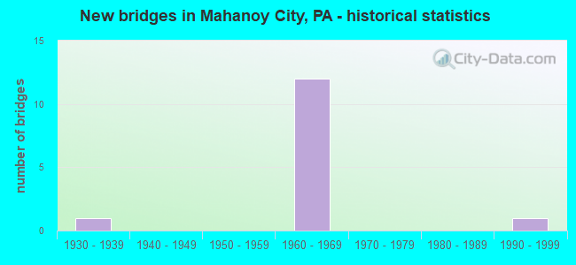
- New bridges - historical statistics
- 11930-1939
- 121960-1969
- 11990-1999

- Reconstructed bridges - Historical Statistics
- 11980-1989
- 41990-1999
- 12000-2009


- Bridge Condition - Deck
- 12.5%Good
- 50.0%Satisfactory
- 12.5%Fair
- 25.0%Poor

- Bridge Condition - Superstructure
- 12.5%Good
- 50.0%Satisfactory
- 25.0%Fair
- 12.5%Poor

- Bridge Condition - Substructure
- 12.5%Good
- 50.0%Satisfactory
- 37.5%Fair

- Bridge Condition - Channel
- 33.3%Satisfactory
- 33.3%Fair
- 33.3%Poor
Find on map >> Show street view
Structure Number: 30511, Location: 0.5 MI. W OF MAHANOY CITY (Lat: 40.808675, Lng: -76.157764), Route carried "on" structure: State highway 54, Year Built: 1966, Year Reconstructed: 1996, Status: Open, Structure Length: 7.62m (25.00ft), Average Daily Traffic: 3,783 (year 2020), Truck Traffic: 10%, Average Future Daily Traffic: 3,242 (year 2032), Design Load: HS 20, Features Intersected: READING & NORTHERN RR
Minimum Vertical Clearance: 30+ m (98+ ft), Kilometerpoint: 21.710, Lanes on structure: 2, Owner: State Highway Agency, Approaching Roadway Width: 11.0m (36.1ft), Material/Design: Steel continuous, Design/Construction: Stringer/Multi-beam, Number Of Spans In Main Unit: 4, Length of Maximum Span: 21.0m (68.9ft), Curb or Sidewalk Widths: Left: 1.5m (4.9ft), Right: 0.5m (1.6ft), Curb-To-Curb Width: 9.8m (32.2ft), Out-to-Out Width: 12.5m (41.0ft)
Condition: Deck: Satisfactory, Superstructure: Satisfactory, Substructure: Fair, Operating Rating: 57.2 metric tons, Method Used To Determine Operating Rating: Load Factor (LF), Inventory Rating: 34.5 metric tons, Method Used To Determine Inventory Rating: Load Factor (LF), Structural Evaluation: Somewhat better than minimum adequacy, Deck Geometry: Meets minimum limits, Underclear: High priority of corrective action, Approach Roadway Alignment: Better than present minimum criteria, Length Of Structure Improvement: 8.60m (28.22ft), Designated Inspection Frequency: Every 24 months, Critical Feature Inspection Frequency: Every 24 months, Other Special Inspection Frequency: Every 12 months, Inspection Date: September 2020, Critical Feature Inspection Date: September 2020, Other Special Inspection Date: September 2021, Bridge Improvement Cost: $69,000, Roadway Improvement Cost: $202,000, Total Project Cost: $927,000, Deck Structure Type: Concrete Cast-file-Place, Wearing Surface/Protective System: Wearing Surface: Latex Concrete
Find on map >> Show street view
Structure Number: 30592, Location: 1 MI.S.OF EXIT 131(37) (Lat: 40.799369, Lng: -76.118903), Route carried "on" structure: Interstate 81, Year Built: 1967, Year Reconstructed: 1990, Status: Open, Structure Length: 7.96m (26.12ft), Average Daily Traffic: 12,352 (year 2021), Truck Traffic: 26%, Average Future Daily Traffic: 15,473 (year 2032), Design Load: HS 20+Mod, Features Intersected: SR 1006 (LR 53037)
Minimum Vertical Clearance: 30+ m (98+ ft), Kilometerpoint: 52.785, Lanes on structure: 2, Lanes under structure: 2, Base Highway Network: Yes, Owner: State Highway Agency, Approaching Roadway Width: 9.1m (29.9ft), Skew: 16 degrees, Material/Design: Prestressed concrete, Design/Construction: Stringer/Multi-beam, Number Of Spans In Main Unit: 3, Length of Maximum Span: 28.7m (94.2ft), Curb-To-Curb Width: 10.2m (33.5ft), Out-to-Out Width: 11.0m (36.1ft)
Condition: Deck: Good, Superstructure: Good, Substructure: Satisfactory, Operating Rating: 82.6 metric tons, Method Used To Determine Operating Rating: Load Factor (LF), Inventory Rating: 23.6 metric tons, Method Used To Determine Inventory Rating: Load Factor (LF), Structural Evaluation: Somewhat better than minimum adequacy, Deck Geometry: Meets minimum limits, Underclear: Somewhat better than minimum adequacy, Approach Roadway Alignment: Equal to present desirable criteria, Length Of Structure Improvement: 8.90m (29.20ft), Designated Inspection Frequency: Every 24 months, Inspection Date: November 2019, Deck Structure Type: Concrete Cast-file-Place, Wearing Surface/Protective System: Wearing Surface: Latex Concrete, Deck Protection: Epoxy Coated Reinforcing
Find on map >> Show street view
Structure Number: 30593, Location: 1 MI. S. OF EXIT 131 (37) (Lat: 40.800000, Lng: -76.118333), Route carried "on" structure: Interstate 81, Year Built: 1967, Year Reconstructed: 1990, Status: Open, Structure Length: 5.73m (18.80ft), Average Daily Traffic: 11,998 (year 2021), Truck Traffic: 26%, Average Future Daily Traffic: 15,148 (year 2032), Design Load: HS 20+Mod, Features Intersected: SR 1006 (LR 53037)
Minimum Vertical Clearance: 30+ m (98+ ft), Kilometerpoint: 52.704, Lanes on structure: 2, Lanes under structure: 2, Base Highway Network: Yes, Owner: State Highway Agency, Approaching Roadway Width: 12.2m (40.0ft), Skew: 15 degrees, Material/Design: Prestressed concrete, Design/Construction: Box Beam or Girders - Single/Spread, Number Of Spans In Main Unit: 3, Length of Maximum Span: 21.3m (69.9ft), Curb or Sidewalk Widths: Left: 0.2m (0.7ft), Right: 0.2m (0.7ft), Curb-To-Curb Width: 12.0m (39.4ft), Out-to-Out Width: 12.8m (42.0ft)
Condition: Deck: Satisfactory, Superstructure: Satisfactory, Substructure: Satisfactory, Operating Rating: 73.5 metric tons, Method Used To Determine Operating Rating: Load Factor (LF), Inventory Rating: 27.2 metric tons, Method Used To Determine Inventory Rating: Load Factor (LF), Structural Evaluation: Equal to present minimum criteria, Deck Geometry: Equal to present minimum criteria, Underclear: Somewhat better than minimum adequacy, Approach Roadway Alignment: Equal to present desirable criteria, Length Of Structure Improvement: 6.70m (21.98ft), Designated Inspection Frequency: Every 24 months, Inspection Date: January 2021, Bridge Improvement Cost: $20,000, Roadway Improvement Cost: $60,000, Total Project Cost: $273,000, Deck Structure Type: Concrete Cast-file-Place, Wearing Surface/Protective System: Wearing Surface: Monolithic Concrete, Deck Protection: Epoxy Coated Reinforcing
Find on map >> Show street view
Structure Number: 30597, Location: EXIT 131(37) S.B. (Lat: 40.810431, Lng: -76.105022), Route carried "on" structure: Interstate 81, Year Built: 1967, Year Reconstructed: 1989, Status: Open, Structure Length: 4.30m (14.11ft), Average Daily Traffic: 13,216 (year 2020), Truck Traffic: 25%, Average Future Daily Traffic: 15,148 (year 2032), Design Load: HS 20+Mod, Features Intersected: PA54(LR290)& I-81 RP B,F
Minimum Vertical Clearance: 30+ m (98+ ft), Kilometerpoint: 55.101, Lanes on structure: 2, Lanes under structure: 8, Base Highway Network: Yes, Owner: State Highway Agency, Approaching Roadway Width: 12.2m (40.0ft), Skew: 13 degrees, Material/Design: Prestressed concrete, Design/Construction: Box Beam or Girders - Single/Spread, Number Of Spans In Main Unit: 2, Length of Maximum Span: 21.3m (69.9ft), Curb-To-Curb Width: 15.4m (50.5ft), Out-to-Out Width: 16.3m (53.5ft)
Condition: Deck: Satisfactory, Superstructure: Satisfactory, Substructure: Satisfactory, Operating Rating: 74.4 metric tons, Method Used To Determine Operating Rating: Load Factor (LF), Inventory Rating: 28.1 metric tons, Method Used To Determine Inventory Rating: Load Factor (LF), Structural Evaluation: Equal to present minimum criteria, Deck Geometry: Superior to present desirable criteria, Underclear: High priority of corrective action, Approach Roadway Alignment: Equal to present desirable criteria, Length Of Structure Improvement: 5.20m (17.06ft), Designated Inspection Frequency: Every 24 months, Inspection Date: March 2021, Deck Structure Type: Concrete Cast-file-Place, Wearing Surface/Protective System: Wearing Surface: Latex Concrete, Deck Protection: Epoxy Coated Reinforcing
Find on map >> Show street view
Structure Number: 30598, Location: EXIT 131(37) N.B. (Lat: 40.810308, Lng: -76.104669), Route carried "on" structure: Interstate 81, Year Built: 1967, Year Reconstructed: 1990, Status: Open, Structure Length: 4.63m (15.19ft), Average Daily Traffic: 12,739 (year 2020), Truck Traffic: 27%, Average Future Daily Traffic: 15,473 (year 2032), Design Load: HS 20+Mod, Features Intersected: PA 54(LR290), RAMP B&C
Minimum Vertical Clearance: 30+ m (98+ ft), Kilometerpoint: 55.200, Lanes on structure: 3, Lanes under structure: 12, Base Highway Network: Yes, Owner: State Highway Agency, Approaching Roadway Width: 12.2m (40.0ft), Skew: 19 degrees, Material/Design: Prestressed concrete, Design/Construction: Box Beam or Girders - Single/Spread, Number Of Spans In Main Unit: 2, Length of Maximum Span: 25.6m (84.0ft), Curb-To-Curb Width: 15.5m (50.9ft), Out-to-Out Width: 16.3m (53.5ft)
Condition: Deck: Satisfactory, Superstructure: Satisfactory, Substructure: Satisfactory, Operating Rating: 60.8 metric tons, Method Used To Determine Operating Rating: Load Factor (LF), Inventory Rating: 24.5 metric tons, Method Used To Determine Inventory Rating: Load Factor (LF), Structural Evaluation: Equal to present minimum criteria, Deck Geometry: Somewhat better than minimum adequacy, Underclear: High priority of corrective action, Approach Roadway Alignment: Equal to present desirable criteria, Length Of Structure Improvement: 5.50m (18.04ft), Designated Inspection Frequency: Every 24 months, Inspection Date: March 2021, Deck Structure Type: Concrete Cast-file-Place, Wearing Surface/Protective System: Wearing Surface: Latex Concrete, Deck Protection: Epoxy Coated Reinforcing
Find on map >> Show street view
Structure Number: 30911, Location: W.OF MAH.CITY @ M.A.H.S. (Lat: 40.809686, Lng: -76.152114), Route carried "on" structure: Alternate Other road , Year Built: 1990, Status: Open, Structure Length: 0.91m (2.99ft), Average Daily Traffic: 2,500 (year 1979), Truck Traffic: 1%, Average Future Daily Traffic: 3,500 (year 2009), Design Load: HS 25 or greater, Features Intersected: MAHANOY CREEK, Facility Carried by Structure: GOLDEN BEAR DRIVE
Minimum Vertical Clearance: 30+ m (98+ ft), Kilometerpoint: 0.000, Lanes on structure: 2, Owner: Town or Township Highway Agency, Approaching Roadway Width: 7.3m (24.0ft), Skew: 1 degrees, Material/Design: Prestressed concrete, Design/Construction: Slab, Number Of Spans In Main Unit: 1, Length of Maximum Span: 8.2m (26.9ft), Curb or Sidewalk Widths: Left: 1.6m (5.2ft), Right: 0.2m (0.7ft), Curb-To-Curb Width: 7.4m (24.3ft), Out-to-Out Width: 9.8m (32.2ft)
Condition: Deck: Poor, Superstructure: Poor, Substructure: Good, Channel: Satisfactory, Operating Rating: 78.0 metric tons, Method Used To Determine Operating Rating: Load Factor (LF), Inventory Rating: 41.7 metric tons, Method Used To Determine Inventory Rating: Load Factor (LF), Structural Evaluation: Meets minimum limits, Deck Geometry: High priority of replacement, Waterway Adequacy: Better than present minimum criteria, Approach Roadway Alignment: Equal to present desirable criteria, Length Of Structure Improvement: 1.60m (5.25ft), Designated Inspection Frequency: Every 24 months, Inspection Date: November 2021, Bridge Improvement Cost: $5,000, Roadway Improvement Cost: $14,000, Total Project Cost: $65,000, Deck Structure Type: Concrete Cast-file-Place, Wearing Surface/Protective System: Wearing Surface: Bituminous
Find on map >> Show street view
Structure Number: 30912, Location: PARK PLACE RD,N.OF M.C. (Lat: 40.821567, Lng: -76.139442), Route carried "on" structure: City street , Year Built: 1961, Status: Open, Structure Length: 0.94m (3.08ft), Average Daily Traffic: 1,300 (year 1977), Truck Traffic: 1%, Average Future Daily Traffic: 1,820 (year 2007), Design Load: HS 20, Features Intersected: N. MAHANOY CREEK, Facility Carried by Structure: PARK PLACE ROAD
Minimum Vertical Clearance: 30+ m (98+ ft), Kilometerpoint: 0.000, Lanes on structure: 2, Owner: Town or Township Highway Agency, Approaching Roadway Width: 6.1m (20.0ft), Material/Design: Steel, Design/Construction: Stringer/Multi-beam, Number Of Spans In Main Unit: 1, Length of Maximum Span: 7.9m (25.9ft), Curb-To-Curb Width: 8.5m (27.9ft), Out-to-Out Width: 9.1m (29.9ft)
Condition: Deck: Poor, Superstructure: Fair, Substructure: Fair, Channel: Poor, Operating Rating: 69.9 metric tons, Method Used To Determine Operating Rating: Load Factor (LF), Inventory Rating: 41.7 metric tons, Method Used To Determine Inventory Rating: Load Factor (LF), Structural Evaluation: Somewhat better than minimum adequacy, Deck Geometry: Somewhat better than minimum adequacy, Waterway Adequacy: Better than present minimum criteria, Approach Roadway Alignment: Equal to present desirable criteria, Length Of Structure Improvement: 1.60m (5.25ft), Designated Inspection Frequency: Every 24 months, Other Special Inspection Frequency: Every 12 months, Inspection Date: August 2021, Other Special Inspection Date: August 2021, Bridge Improvement Cost: $3,000, Roadway Improvement Cost: $10,000, Total Project Cost: $45,000, Deck Structure Type: Open Grating
Find on map >> Show street view
Structure Number: 30998, Location: MARKET ST.1 BLK.S.OF SR54 (Lat: 40.812800, Lng: -76.138700), Route carried "on" structure: City street , Year Built: 1935, Year Reconstructed: 2000, Status: Open, Structure Length: 0.70m (2.30ft), Average Daily Traffic: 100 (year 2009), Truck Traffic: 1%, Average Future Daily Traffic: 187 (year 2030), Design Load: H 15, Features Intersected: MAHANOY CREEK, Facility Carried by Structure: MARKET STREET
Minimum Vertical Clearance: 30+ m (98+ ft), Kilometerpoint: 0.000, Lanes on structure: 1, Owner: City or Municipal Highway Agency, Approaching Roadway Width: 0.3m (1.0ft), Skew: 9 degrees, Number Of Spans In Main Unit: 1, Length of Maximum Span: 6.1m (20.0ft), Curb-To-Curb Width: 9.1m (29.9ft), Out-to-Out Width: 9.1m (29.9ft)
Condition: Deck: Fair, Superstructure: Fair, Substructure: Fair, Channel: Fair, Culverts: Satisfactory, Operating Rating: 49.0 metric tons, Method Used To Determine Operating Rating: Field evaluation and documented engineering judgment, Inventory Rating: 32.7 metric tons, Method Used To Determine Inventory Rating: Field evaluation and documented engineering judgment, Structural Evaluation: Somewhat better than minimum adequacy, Deck Geometry: Better than present minimum criteria, Waterway Adequacy: Equal to present desirable criteria, Approach Roadway Alignment: Equal to present desirable criteria, Designated Inspection Frequency: Every 24 months, Inspection Date: November 2020, Deck Structure Type: Other, Wearing Surface/Protective System: Wearing Surface: Bituminous, Deck Protection: Other
Find on map >> Show street view
Structure Number: 30592, Location: 1 MI.S.OF EXIT 131(37) (Lat: 40.799369, Lng: -76.118903), Route carried "under" structure: State highway , Year Built: 1967, Structure Length: 0. m, Average Daily Traffic: 2,101 (year 2020), Truck Traffic: 3%, Features Intersected: SR 1006 (LR 53037), Facility Carried by Structure: I-81 NB(LR 1005)
Minimum Vertical Clearance: 4.63m (15.19ft), Kilometerpoint: 17.421, Lanes on structure: 2, Lanes under structure: 2, Material/Design: Prestressed concrete, Design/Construction: Stringer/Multi-beam, Length of Maximum Span: 28.7m (94.2ft)
Find on map >> Show street view
Structure Number: 30593, Location: 1 MI. S. OF EXIT 131 (37) (Lat: 40.800000, Lng: -76.118333), Route carried "under" structure: State highway , Year Built: 1967, Structure Length: 0. m, Average Daily Traffic: 2,101 (year 2020), Truck Traffic: 3%, Features Intersected: SR 1006 (LR 53037), Facility Carried by Structure: I-81 SB (LR 1005)
Minimum Vertical Clearance: 4.36m (14.30ft), Kilometerpoint: 17.421, Lanes on structure: 2, Lanes under structure: 2, Material/Design: Prestressed concrete, Design/Construction: Box Beam or Girders - Single/Spread, Length of Maximum Span: 21.3m (69.9ft)
Find on map >> Show street view
Structure Number: 30597, Location: EXIT 131(37) S.B. (Lat: 40.810431, Lng: -76.105022), Route carried "under" structure: State highway 54, Year Built: 1967, Structure Length: 0. m, Average Daily Traffic: 2,720 (year 2020), Truck Traffic: 7%, Features Intersected: PA54(LR290)& I-81 RP B,F, Facility Carried by Structure: I-81 SB (LR 1005)
Minimum Vertical Clearance: 5.43m (17.81ft), Kilometerpoint: 26.400, Lanes on structure: 2, Lanes under structure: 4, Material/Design: Prestressed concrete, Design/Construction: Box Beam or Girders - Single/Spread, Length of Maximum Span: 21.3m (69.9ft)
Find on map >> Show street view
Structure Number: 30597, Location: EXIT 131(37) S.B. (Lat: 40.810431, Lng: -76.105022), Route carried "under" structure: State highway 54, Year Built: 1967, Structure Length: 0. m, Average Daily Traffic: 2,394 (year 2021), Truck Traffic: 7%, Features Intersected: PA54(LR290)& I-81 RP B,F, Facility Carried by Structure: I-81 SB (LR 1005)
Minimum Vertical Clearance: 4.82m (15.81ft), Kilometerpoint: 26.392, Lanes on structure: 2, Lanes under structure: 4, Material/Design: Prestressed concrete, Design/Construction: Box Beam or Girders - Single/Spread, Length of Maximum Span: 21.3m (69.9ft)
Find on map >> Show street view
Structure Number: 30598, Location: EXIT 131(37) N.B. (Lat: 40.810308, Lng: -76.104669), Route carried "under" structure: State highway 54, Year Built: 1967, Structure Length: 0. m, Average Daily Traffic: 2,394 (year 2021), Truck Traffic: 7%, Features Intersected: PA 54(LR290), RAMP B&C, Facility Carried by Structure: I-81 NB(LR 1005)
Minimum Vertical Clearance: 4.65m (15.26ft), Kilometerpoint: 26.392, Lanes on structure: 3, Lanes under structure: 6, Material/Design: Prestressed concrete, Design/Construction: Box Beam or Girders - Single/Spread, Length of Maximum Span: 25.6m (84.0ft)
Find on map >> Show street view
Structure Number: 30598, Location: EXIT 131(37) N.B. (Lat: 40.810308, Lng: -76.104669), Route carried "under" structure: State highway 54, Year Built: 1967, Structure Length: 0. m, Average Daily Traffic: 2,720 (year 2020), Truck Traffic: 7%, Features Intersected: PA 54(LR290), RAMP B&C, Facility Carried by Structure: I-81 NB(LR 1005)
Minimum Vertical Clearance: 5.61m (18.41ft), Kilometerpoint: 26.400, Lanes on structure: 3, Lanes under structure: 6, Material/Design: Prestressed concrete, Design/Construction: Box Beam or Girders - Single/Spread, Length of Maximum Span: 25.6m (84.0ft)