Bridge Statistics for Malad City, Idaho (ID)
Condition, Traffic, Stress, Structural Evaluation, Project Costs
- National Bridge Inventory (NBI) Statistics
- 10Number of bridges
- 72ft / 22.1mTotal length
- $2,317,000Total costs
- 39,400Total average daily traffic
- 8,250Total average daily truck traffic
- National Bridge Inventory (NBI) Registered Bridges for Malad City
- No street view available for this location
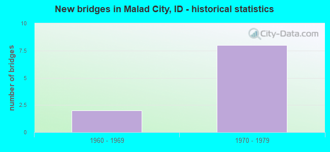
- New bridges - historical statistics
- 21960-1969
- 81970-1979


- Bridge Condition - Superstructure
- 60.0%Satisfactory
- 40.0%Fair
Find on map >> Show street view
Structure Number: 1099, Location: 1.5 S. MALAD (Lat: 42.163000, Lng: -112.220972), Route carried "on" structure: Interstate 15, Year Built: 1975, Status: Open, Structure Length: 3.72m (12.20ft), Average Daily Traffic: 6,000 (year 2019), Truck Traffic: 22%, Average Future Daily Traffic: 9,000 (year 2039), Design Load: HS 20, Features Intersected: TWO MILE RD.GS
Minimum Vertical Clearance: 30+ m (98+ ft), Kilometerpoint: 18.219, Lanes on structure: 2, Lanes under structure: 2, Base Highway Network: Yes, Owner: State Highway Agency, Approaching Roadway Width: 12.2m (40.0ft), Skew: 1 degrees, Material/Design: Prestressed concrete, Design/Construction: Stringer/Multi-beam, Number Of Spans In Main Unit: 3, Length of Maximum Span: 18.3m (60.0ft), Curb-To-Curb Width: 12.4m (40.7ft), Out-to-Out Width: 13.3m (43.6ft)
Condition: Deck: Satisfactory, Superstructure: Satisfactory, Substructure: Satisfactory, Operating Rating: 57.2 metric tons, Method Used To Determine Operating Rating: Load Factor (LF), Inventory Rating: 30.8 metric tons, Method Used To Determine Inventory Rating: Load Factor (LF), Structural Evaluation: Equal to present minimum criteria, Deck Geometry: Better than present minimum criteria, Underclear: Equal to present minimum criteria, Approach Roadway Alignment: Equal to present desirable criteria, Designated Inspection Frequency: Every 24 months, Inspection Date: October 2020, Deck Structure Type: Concrete Cast-file-Place, Wearing Surface/Protective System: Wearing Surface: Latex Concrete
Find on map >> Show street view
Structure Number: 10995, Location: 1.5 S. MALAD (Lat: 42.163306, Lng: -112.221556), Route carried "on" structure: Interstate 15, Year Built: 1975, Status: Open, Structure Length: 3.72m (12.20ft), Average Daily Traffic: 6,000 (year 2019), Truck Traffic: 22%, Average Future Daily Traffic: 9,000 (year 2039), Design Load: HS 20, Features Intersected: TWO MILE RD.GS
Minimum Vertical Clearance: 30+ m (98+ ft), Kilometerpoint: 18.221, Lanes on structure: 2, Lanes under structure: 2, Base Highway Network: Yes, Owner: State Highway Agency, Approaching Roadway Width: 12.2m (40.0ft), Skew: 1 degrees, Material/Design: Prestressed concrete, Design/Construction: Stringer/Multi-beam, Number Of Spans In Main Unit: 3, Length of Maximum Span: 18.3m (60.0ft), Curb-To-Curb Width: 12.4m (40.7ft), Out-to-Out Width: 13.3m (43.6ft)
Condition: Deck: Satisfactory, Superstructure: Satisfactory, Substructure: Satisfactory, Operating Rating: 57.2 metric tons, Method Used To Determine Operating Rating: Load Factor (LF), Inventory Rating: 30.8 metric tons, Method Used To Determine Inventory Rating: Load Factor (LF), Structural Evaluation: Equal to present minimum criteria, Deck Geometry: Better than present minimum criteria, Underclear: Better than present minimum criteria, Approach Roadway Alignment: Equal to present desirable criteria, Designated Inspection Frequency: Every 24 months, Inspection Date: October 2020, Deck Structure Type: Concrete Cast-file-Place, Wearing Surface/Protective System: Wearing Surface: Latex Concrete
Find on map >> Show street view
Structure Number: 11, Location: AT MALAD (Lat: 42.183014, Lng: -112.232408), Route carried "on" structure: Interstate 15, Year Built: 1975, Status: Open, Structure Length: 3.99m (13.09ft), Average Daily Traffic: 6,000 (year 2019), Truck Traffic: 22%, Average Future Daily Traffic: 9,000 (year 2039), Design Load: HS 20, Features Intersected: SH 38;MALAD CITY IC
Minimum Vertical Clearance: 30+ m (98+ ft), Kilometerpoint: 20.653, Lanes on structure: 2, Lanes under structure: 2, Base Highway Network: Yes, Owner: State Highway Agency, Approaching Roadway Width: 11.6m (38.1ft), Skew: 2 degrees, Material/Design: Concrete, Design/Construction: Box Beam or Girders - Single/Spread, Number Of Spans In Main Unit: 1, Length of Maximum Span: 39.6m (129.9ft), Curb-To-Curb Width: 12.4m (40.7ft), Out-to-Out Width: 13.3m (43.6ft)
Condition: Deck: Satisfactory, Superstructure: Fair, Substructure: Satisfactory, Operating Rating: 46.7 metric tons, Method Used To Determine Operating Rating: Load and Resistance Factor Rating (LRFR) rating reported by rating factor(RF) method using HL-93 loadings, Inventory Rating: 34.0 metric tons, Method Used To Determine Inventory Rating: Load and Resistance Factor Rating (LRFR) rating reported by rating factor(RF) method using HL-93 loadings, Structural Evaluation: Somewhat better than minimum adequacy, Deck Geometry: Better than present minimum criteria, Underclear: Superior to present desirable criteria, Approach Roadway Alignment: Equal to present desirable criteria, Designated Inspection Frequency: Every 24 months, Inspection Date: October 2020, Deck Structure Type: Concrete Cast-file-Place, Wearing Surface/Protective System: Wearing Surface: Bituminous
Find on map >> Show street view
Structure Number: 11005, Location: AT MALAD (Lat: 42.183256, Lng: -112.233131), Route carried "on" structure: Interstate 15, Year Built: 1975, Status: Open, Structure Length: 3.99m (13.09ft), Average Daily Traffic: 6,000 (year 2019), Truck Traffic: 22%, Average Future Daily Traffic: 9,000 (year 2039), Design Load: HS 20, Features Intersected: SH 38;MALAD CITY IC
Minimum Vertical Clearance: 30+ m (98+ ft), Kilometerpoint: 20.654, Lanes on structure: 2, Lanes under structure: 2, Base Highway Network: Yes, Owner: State Highway Agency, Approaching Roadway Width: 12.2m (40.0ft), Skew: 2 degrees, Material/Design: Concrete, Design/Construction: Box Beam or Girders - Single/Spread, Number Of Spans In Main Unit: 1, Length of Maximum Span: 39.6m (129.9ft), Curb-To-Curb Width: 12.4m (40.7ft), Out-to-Out Width: 13.3m (43.6ft)
Condition: Deck: Satisfactory, Superstructure: Fair, Substructure: Satisfactory, Operating Rating: 46.7 metric tons, Method Used To Determine Operating Rating: Load and Resistance Factor Rating (LRFR) rating reported by rating factor(RF) method using HL-93 loadings, Inventory Rating: 34.0 metric tons, Method Used To Determine Inventory Rating: Load and Resistance Factor Rating (LRFR) rating reported by rating factor(RF) method using HL-93 loadings, Structural Evaluation: Somewhat better than minimum adequacy, Deck Geometry: Better than present minimum criteria, Underclear: Superior to present desirable criteria, Approach Roadway Alignment: Equal to present desirable criteria, Designated Inspection Frequency: Every 24 months, Inspection Date: October 2020, Deck Structure Type: Concrete Cast-file-Place, Wearing Surface/Protective System: Wearing Surface: Bituminous
Find on map >> Show street view
Structure Number: 14095, Location: 3.9 N. MALAD (Lat: 42.234722, Lng: -112.231111), Route carried "on" structure: State highway 36, Year Built: 1964, Status: Open, Structure Length: 6.71m (22.01ft), Average Daily Traffic: 500 (year 2019), Truck Traffic: 20%, Average Future Daily Traffic: 750 (year 2039), Design Load: HS 20, Features Intersected: I 15;DEEP CR;SH 36 IC
Minimum Vertical Clearance: 30+ m (98+ ft), Kilometerpoint: 160.998, Lanes on structure: 2, Lanes under structure: 4, Owner: State Highway Agency, Approaching Roadway Width: 7.9m (25.9ft), Material/Design: Prestressed concrete, Design/Construction: Stringer/Multi-beam, Number Of Spans In Main Unit: 3, Number Of Approach Spans: 2, Length of Maximum Span: 14.3m (46.9ft), Curb-To-Curb Width: 8.6m (28.2ft), Out-to-Out Width: 10.0m (32.8ft)
Condition: Deck: Satisfactory, Superstructure: Satisfactory, Substructure: Satisfactory, Operating Rating: 63.5 metric tons, Method Used To Determine Operating Rating: Load Factor (LF), Inventory Rating: 38.1 metric tons, Method Used To Determine Inventory Rating: Load Factor (LF), Structural Evaluation: Equal to present minimum criteria, Deck Geometry: Somewhat better than minimum adequacy, Underclear: Meets minimum limits, Approach Roadway Alignment: Equal to present desirable criteria, Length Of Structure Improvement: 7.71m (25.30ft), Designated Inspection Frequency: Every 24 months, Inspection Date: July 2020, Bridge Improvement Cost: $1,545,000, Roadway Improvement Cost: $154,000, Total Project Cost: $2,317,000 ( Estimate for 2017), Deck Structure Type: Concrete Cast-file-Place, Wearing Surface/Protective System: Wearing Surface: Monolithic Concrete
Find on map >> Show street view
Structure Number: 1099, Location: 1.5 S. MALAD (Lat: 42.163000, Lng: -112.220972), Route carried "under" structure: County highway , Year Built: 1975, Structure Length: 0. m, Average Daily Traffic: 150 (year 2018), Truck Traffic: 5%, Features Intersected: TWO MILE RD.GS, Facility Carried by Structure: I 15 NBL
Minimum Vertical Clearance: 4.57m (14.99ft), Kilometerpoint: 169.869, Lanes on structure: 2, Lanes under structure: 2, Material/Design: Prestressed concrete, Design/Construction: Stringer/Multi-beam, Length of Maximum Span: 18.3m (60.0ft)
Find on map >> Show street view
Structure Number: 10995, Location: 1.5 S. MALAD (Lat: 42.163306, Lng: -112.221556), Route carried "under" structure: County highway , Year Built: 1975, Structure Length: 0. m, Average Daily Traffic: 150 (year 2018), Truck Traffic: 5%, Features Intersected: TWO MILE RD.GS, Facility Carried by Structure: I 15 SBL
Minimum Vertical Clearance: 5.05m (16.57ft), Kilometerpoint: 169.828, Lanes on structure: 2, Lanes under structure: 2, Material/Design: Prestressed concrete, Design/Construction: Stringer/Multi-beam, Length of Maximum Span: 18.3m (60.0ft)
Find on map >> Show street view
Structure Number: 11, Location: AT MALAD (Lat: 42.183014, Lng: -112.232408), Route carried "under" structure: State highway 38, Year Built: 1975, Structure Length: 0. m, Average Daily Traffic: 1,800 (year 2018), Truck Traffic: 6%, Features Intersected: SH 38;MALAD CITY IC, Facility Carried by Structure: I 15 NBL
Minimum Vertical Clearance: 5.36m (17.59ft), Kilometerpoint: 0.098, Lanes on structure: 2, Lanes under structure: 2, Material/Design: Concrete, Design/Construction: Box Beam or Girders - Single/Spread, Length of Maximum Span: 39.6m (129.9ft)
Find on map >> Show street view
Structure Number: 11005, Location: AT MALAD (Lat: 42.183256, Lng: -112.233131), Route carried "under" structure: State highway 38, Year Built: 1975, Structure Length: 0. m, Average Daily Traffic: 1,800 (year 2018), Truck Traffic: 6%, Features Intersected: SH 38;MALAD CITY IC, Facility Carried by Structure: I 15 SBL
Minimum Vertical Clearance: 5.49m (18.01ft), Kilometerpoint: 0.100, Lanes on structure: 2, Lanes under structure: 2, Material/Design: Concrete, Design/Construction: Box Beam or Girders - Single/Spread, Length of Maximum Span: 39.6m (129.9ft)
Find on map >> Show street view
Structure Number: 14095, Location: 3.9 N. MALAD (Lat: 42.234722, Lng: -112.231111), Route carried "under" structure: Interstate 15, Year Built: 1964, Structure Length: 0. m, Average Daily Traffic: 11,000 (year 2018), Truck Traffic: 24%, Features Intersected: I 15;DEEP CR;SH 36 IC, Facility Carried by Structure: SH 36
Minimum Vertical Clearance: 5.11m (16.77ft), Kilometerpoint: 26.635, Lanes on structure: 2, Lanes under structure: 4, Material/Design: Prestressed concrete, Design/Construction: Stringer/Multi-beam, Length of Maximum Span: 14.3m (46.9ft)