Bridge Statistics for Malvern, Alabama (AL)
Condition, Traffic, Stress, Structural Evaluation, Project Costs
- National Bridge Inventory (NBI) Statistics
- 24Number of bridges
- 200ft / 60.6mTotal length
- $20,080,000Total costs
- 25,759Total average daily traffic
- 1,631Total average daily truck traffic
- 37,674Total future (year 2030) average daily traffic
- National Bridge Inventory (NBI) Registered Bridges for Malvern
- No street view available for this location
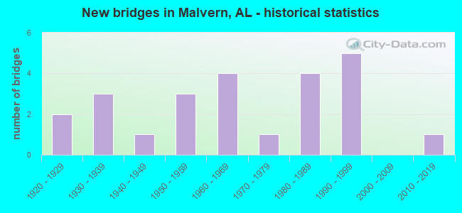
- New bridges - historical statistics
- 21920-1929
- 31930-1939
- 11940-1949
- 31950-1959
- 41960-1969
- 11970-1979
- 41980-1989
- 51990-1999
- 12010-2019

- Reconstructed bridges - Historical Statistics
- 11960-1969
- 01970-1979
- 11980-1989


- Bridge Condition - Deck
- 7.7%Very good
- 38.5%Good
- 46.2%Satisfactory
- 7.7%Fair

- Bridge Condition - Superstructure
- 7.7%Very good
- 53.8%Good
- 30.8%Satisfactory
- 7.7%Fair

- Bridge Condition - Substructure
- 7.7%Very good
- 38.5%Good
- 30.8%Satisfactory
- 15.4%Fair
- 7.7%Poor

- Bridge Condition - Channel
- 12.5%Very good
- 33.3%Good
- 25.0%Satisfactory
- 25.0%Fair
- 4.2%Poor

- Bridge Condition - Culverts
- 9.1%Very good
- 18.2%Good
- 36.4%Satisfactory
- 36.4%Fair
Find on map >> Show street view
Structure Number: 187, Location: 4.7 MI N JCT US72 * SR65 (Lat: 34.730897, Lng: -86.289242), Route carried "on" structure: State highway 65, Year Built: 1922, Status: Open, Structure Length: 0.76m (2.49ft), Average Daily Traffic: 934 (year 2020), Truck Traffic: 2%, Average Future Daily Traffic: 1,308 (year 2040), Design Load: H 10, Features Intersected: BRANCH
Minimum Vertical Clearance: 30+ m (98+ ft), Kilometerpoint: 7.508, Lanes on structure: 2, Owner: State Highway Agency, Approaching Roadway Width: 7.6m (24.9ft), Material/Design: Concrete continuous, Design/Construction: Slab, Number Of Spans In Main Unit: 2, Length of Maximum Span: 3.0m (9.8ft), Curb-To-Curb Width: 7.6m (24.9ft), Out-to-Out Width: 8.5m (27.9ft)
Condition: Deck: Good, Superstructure: Good, Substructure: Good, Channel: Satisfactory, Operating Rating: 32.7 metric tons, Method Used To Determine Operating Rating: Field evaluation and documented engineering judgment, Inventory Rating: 23.6 metric tons, Method Used To Determine Inventory Rating: Field evaluation and documented engineering judgment, Structural Evaluation: Equal to present minimum criteria, Deck Geometry: Meets minimum limits, Waterway Adequacy: Equal to present minimum criteria, Approach Roadway Alignment: Equal to present desirable criteria, Length Of Structure Improvement: 1.41m (4.63ft), Designated Inspection Frequency: Every 24 months, Inspection Date: August 2021, Bridge Improvement Cost: $271,000, Roadway Improvement Cost: $27,000, Total Project Cost: $298,000 ( Estimate for 2022), Deck Structure Type: Concrete Cast-file-Place, Wearing Surface/Protective System: Wearing Surface: Bituminous
Find on map >> Show street view
Structure Number: 1868, Location: 0.4 MI N JCT FAS RT 45 03 (Lat: 34.814294, Lng: -86.758131), Route carried "on" structure: County highway 337, Year Built: 1938, Status: Open, Structure Length: 0.73m (2.40ft), Average Daily Traffic: 220 (year 1992), Truck Traffic: 1%, Average Future Daily Traffic: 325 (year 2040), Design Load: H 15, Features Intersected: SMITH BRANCH, Facility Carried by Structure: ORVILLE SMITH RD
Minimum Vertical Clearance: 30+ m (98+ ft), Kilometerpoint: 0.010, Lanes on structure: 2, Owner: County Highway Agency, Approaching Roadway Width: 7.3m (24.0ft), Material/Design: Masonry, Design/Construction: Culvert, Number Of Spans In Main Unit: 2, Length of Maximum Span: 3.7m (12.1ft), Curb-To-Curb Width: 6.2m (20.3ft), Out-to-Out Width: 6.7m (22.0ft)
Condition: Channel: Fair, Culverts: Fair, Operating Rating: 32.7 metric tons, Method Used To Determine Operating Rating: Field evaluation and documented engineering judgment, Inventory Rating: 23.6 metric tons, Method Used To Determine Inventory Rating: Field evaluation and documented engineering judgment, Structural Evaluation: Somewhat better than minimum adequacy, Deck Geometry: Meets minimum limits, Waterway Adequacy: Equal to present minimum criteria, Approach Roadway Alignment: Equal to present minimum criteria, Length Of Structure Improvement: 1.38m (4.53ft), Designated Inspection Frequency: Every 24 months, Inspection Date: November 2020, Bridge Improvement Cost: $175,000, Roadway Improvement Cost: $18,000, Total Project Cost: $193,000 ( Estimate for 2022)
Find on map >> Show street view
Structure Number: 1872, Location: 1 MI E JCT CO RD 375 (Lat: 34.492097, Lng: -86.483458), Route carried "on" structure: County highway 376, Year Built: 1938, Status: Open, Structure Length: 0.73m (2.40ft), Average Daily Traffic: 75 (year 1992), Average Future Daily Traffic: 90 (year 2040), Design Load: H 15, Features Intersected: TURNER BRANCH, Facility Carried by Structure: C C IVEY RD
Minimum Vertical Clearance: 30+ m (98+ ft), Kilometerpoint: 0.010, Lanes on structure: 2, Owner: County Highway Agency, Approaching Roadway Width: 6.7m (22.0ft), Material/Design: Masonry, Design/Construction: Culvert, Number Of Spans In Main Unit: 2, Length of Maximum Span: 3.7m (12.1ft), Curb-To-Curb Width: 6.2m (20.3ft), Out-to-Out Width: 6.7m (22.0ft)
Condition: Channel: Fair, Culverts: Fair, Operating Rating: 32.7 metric tons, Method Used To Determine Operating Rating: Field evaluation and documented engineering judgment, Inventory Rating: 23.6 metric tons, Method Used To Determine Inventory Rating: Field evaluation and documented engineering judgment, Structural Evaluation: Somewhat better than minimum adequacy, Deck Geometry: Somewhat better than minimum adequacy, Waterway Adequacy: Somewhat better than minimum adequacy, Approach Roadway Alignment: Somewhat better than minimum adequacy, Length Of Structure Improvement: 1.38m (4.53ft), Designated Inspection Frequency: Every 24 months, Inspection Date: March 2020, Bridge Improvement Cost: $175,000, Roadway Improvement Cost: $18,000, Total Project Cost: $193,000 ( Estimate for 2022)
Find on map >> Show street view
Structure Number: 1873, Location: 2.2 MI NE HURRICANECHAPEL (Lat: 34.810061, Lng: -86.366136), Route carried "on" structure: County highway 415, Year Built: 1938, Status: Posted for load, Structure Length: 0.85m (2.79ft), Average Daily Traffic: 60 (year 1992), Average Future Daily Traffic: 80 (year 2034), Design Load: H 15, Features Intersected: MOLDER BRANCH, Facility Carried by Structure: BOB STILES RD
Minimum Vertical Clearance: 30+ m (98+ ft), Kilometerpoint: 0.010, Lanes on structure: 2, Owner: County Highway Agency, Approaching Roadway Width: 7.3m (24.0ft), Material/Design: Steel, Design/Construction: Stringer/Multi-beam, Number Of Spans In Main Unit: 1, Length of Maximum Span: 8.5m (27.9ft), Curb-To-Curb Width: 5.5m (18.0ft), Out-to-Out Width: 5.9m (19.4ft)
Condition: Deck: Fair, Superstructure: Fair, Substructure: Poor, Channel: Poor, Operating Rating: 2.7 metric tons, Method Used To Determine Operating Rating: Load Factor (LF), Inventory Rating: 1.8 metric tons, Method Used To Determine Inventory Rating: Load Factor (LF), Structural Evaluation: High priority of replacement, Deck Geometry: Meets minimum limits, Waterway Adequacy: Somewhat better than minimum adequacy, Approach Roadway Alignment: Somewhat better than minimum adequacy, Bridge Posting: Required (Relationship of Operating Rating to Maximum Legal Load: > 39.9% below), Length Of Structure Improvement: 1.51m (4.95ft), Designated Inspection Frequency: Every 24 months, Other Special Inspection Frequency: Every 12 months, Inspection Date: September 2020, Other Special Inspection Date: September 2021, Bridge Improvement Cost: $197,000, Roadway Improvement Cost: $20,000, Total Project Cost: $217,000 ( Estimate for 2022), Deck Structure Type: Concrete Cast-file-Place, Wearing Surface/Protective System: Wearing Surface: Bituminous
Find on map >> Show street view
Structure Number: 2777, Location: 3 MILES S.W.OF MALVERN (Lat: 31.096625, Lng: -85.501511), Route carried "on" structure: County highway , Year Built: 1944, Year Reconstructed: 1992, Status: Posted for load, Structure Length: 0.94m (3.08ft), Average Daily Traffic: 50 (year 2020), Average Future Daily Traffic: 135 (year 2040), Features Intersected: CHESTNUT BRANCH, Facility Carried by Structure: CHIPOLA ROAD
Minimum Vertical Clearance: 30+ m (98+ ft), Kilometerpoint: 0.010, Lanes on structure: 1, Owner: County Highway Agency, Approaching Roadway Width: 6.1m (20.0ft), Material/Design: Wood or Timber, Design/Construction: Stringer/Multi-beam, Number Of Spans In Main Unit: 2, Length of Maximum Span: 4.6m (15.1ft), Curb-To-Curb Width: 4.6m (15.1ft), Out-to-Out Width: 5.0m (16.4ft)
Condition: Deck: Satisfactory, Superstructure: Satisfactory, Substructure: Good, Channel: Good, Operating Rating: 27.4 metric tons, Method Used To Determine Operating Rating: Allowable Stress (AS), Inventory Rating: 20.2 metric tons, Method Used To Determine Inventory Rating: Allowable Stress (AS), Structural Evaluation: Somewhat better than minimum adequacy, Deck Geometry: Better than present minimum criteria, Waterway Adequacy: Meets minimum limits, Approach Roadway Alignment: Better than present minimum criteria, Bridge Posting: Required (Relationship of Operating Rating to Maximum Legal Load: > 39.9% below), Length Of Structure Improvement: 1.61m (5.28ft), Designated Inspection Frequency: Every 24 months, Other Special Inspection Frequency: Every 12 months, Inspection Date: November 2020, Other Special Inspection Date: November 2021, Bridge Improvement Cost: $176,000, Roadway Improvement Cost: $18,000, Total Project Cost: $194,000 ( Estimate for 2022), Deck Structure Type: Wood or Timber, Wearing Surface/Protective System: Wearing Surface: Wood or Timber
Find on map >> Show street view
Structure Number: 3574, Location: 4 MI. NE OF SLOCOMB (Lat: 31.161094, Lng: -85.552389), Route carried "on" structure: County highway 73, Year Built: 1958, Status: Open, Structure Length: 0.95m (3.12ft), Average Daily Traffic: 130 (year 2021), Truck Traffic: 1%, Average Future Daily Traffic: 178 (year 2041), Design Load: H 15, Features Intersected: BEAR CREEK
Minimum Vertical Clearance: 30+ m (98+ ft), Kilometerpoint: 0.010, Lanes on structure: 2, Owner: County Highway Agency, Approaching Roadway Width: 6.1m (20.0ft), Material/Design: Concrete, Design/Construction: Culvert, Number Of Spans In Main Unit: 3, Length of Maximum Span: 3.0m (9.8ft)
Condition: Channel: Satisfactory, Culverts: Fair, Operating Rating: 47.0 metric tons, Method Used To Determine Operating Rating: Load Factor (LF), Inventory Rating: 28.2 metric tons, Method Used To Determine Inventory Rating: Load Factor (LF), Structural Evaluation: Somewhat better than minimum adequacy, Waterway Adequacy: Equal to present minimum criteria, Approach Roadway Alignment: Equal to present desirable criteria, Length Of Structure Improvement: 1.63m (5.35ft), Designated Inspection Frequency: Every 24 months, Inspection Date: Febuary 2021, Bridge Improvement Cost: $282,000, Roadway Improvement Cost: $28,000, Total Project Cost: $310,000 ( Estimate for 2022)
Find on map >> Show street view
Structure Number: 3975, Location: 3 MI NW OF MALVERN (Lat: 31.174878, Lng: -85.536697), Route carried "on" structure: County highway 49, Year Built: 1951, Status: Open, Structure Length: 0.95m (3.12ft), Average Daily Traffic: 305 (year 2021), Truck Traffic: 1%, Average Future Daily Traffic: 370 (year 2041), Design Load: H 15, Features Intersected: SASSER BRANCH
Minimum Vertical Clearance: 30+ m (98+ ft), Kilometerpoint: 0.010, Lanes on structure: 2, Owner: County Highway Agency, Approaching Roadway Width: 6.1m (20.0ft), Material/Design: Concrete, Design/Construction: Culvert, Number Of Spans In Main Unit: 3, Length of Maximum Span: 3.0m (9.8ft)
Condition: Channel: Satisfactory, Culverts: Satisfactory, Operating Rating: 50.7 metric tons, Method Used To Determine Operating Rating: Load Factor (LF), Inventory Rating: 30.4 metric tons, Method Used To Determine Inventory Rating: Load Factor (LF), Structural Evaluation: Equal to present minimum criteria, Waterway Adequacy: Meets minimum limits, Approach Roadway Alignment: Equal to present minimum criteria, Length Of Structure Improvement: 1.63m (5.35ft), Designated Inspection Frequency: Every 24 months, Inspection Date: Febuary 2021, Bridge Improvement Cost: $282,000, Roadway Improvement Cost: $28,000, Total Project Cost: $310,000 ( Estimate for 2022)
Find on map >> Show street view
Structure Number: 5027, Location: 2 MI. SE OF MALVERN (Lat: 31.116969, Lng: -85.486144), Route carried "on" structure: County highway 93, Year Built: 1955, Status: Open, Structure Length: 1.14m (3.74ft), Average Daily Traffic: 207 (year 2021), Truck Traffic: 1%, Average Future Daily Traffic: 588 (year 2041), Design Load: H 15, Features Intersected: BIG CREEK
Minimum Vertical Clearance: 30+ m (98+ ft), Kilometerpoint: 0.010, Lanes on structure: 2, Owner: County Highway Agency, Approaching Roadway Width: 6.1m (20.0ft), Material/Design: Concrete, Design/Construction: Culvert, Number Of Spans In Main Unit: 3, Length of Maximum Span: 3.7m (12.1ft)
Condition: Channel: Fair, Culverts: Fair, Operating Rating: 63.6 metric tons, Method Used To Determine Operating Rating: Load Factor (LF), Inventory Rating: 38.1 metric tons, Method Used To Determine Inventory Rating: Load Factor (LF), Structural Evaluation: Somewhat better than minimum adequacy, Waterway Adequacy: Meets minimum limits, Approach Roadway Alignment: Equal to present minimum criteria, Length Of Structure Improvement: 1.81m (5.94ft), Designated Inspection Frequency: Every 24 months, Inspection Date: Febuary 2021, Bridge Improvement Cost: $543,000, Roadway Improvement Cost: $54,000, Total Project Cost: $597,000 ( Estimate for 2022)
Find on map >> Show street view
Structure Number: 7277, Location: 6 MI. NE OF SLOCOMB (Lat: 31.190581, Lng: -85.544650), Route carried "on" structure: County highway 68, Year Built: 1961, Status: Posted for load, Structure Length: 4.15m (13.62ft), Average Daily Traffic: 282 (year 2020), Truck Traffic: 5%, Average Future Daily Traffic: 392 (year 2040), Design Load: H 15, Features Intersected: BEAR CREEK
Minimum Vertical Clearance: 30+ m (98+ ft), Kilometerpoint: 0.010, Lanes on structure: 2, Owner: County Highway Agency, Approaching Roadway Width: 6.1m (20.0ft), Material/Design: Concrete, Design/Construction: Tee Beam, Number Of Spans In Main Unit: 4, Length of Maximum Span: 10.4m (34.1ft), Curb-To-Curb Width: 6.6m (21.7ft), Out-to-Out Width: 7.1m (23.3ft)
Condition: Deck: Good, Superstructure: Good, Substructure: Good, Channel: Good, Operating Rating: 35.7 metric tons, Method Used To Determine Operating Rating: Load Factor (LF), Inventory Rating: 21.4 metric tons, Method Used To Determine Inventory Rating: Load Factor (LF), Structural Evaluation: Equal to present minimum criteria, Deck Geometry: Meets minimum limits, Waterway Adequacy: Equal to present minimum criteria, Approach Roadway Alignment: Meets minimum limits, Bridge Posting: Required (Relationship of Operating Rating to Maximum Legal Load: 0.1 - 9.9% below), Length Of Structure Improvement: 5.12m (16.80ft), Designated Inspection Frequency: Every 24 months, Other Special Inspection Frequency: Every 12 months, Inspection Date: September 2020, Other Special Inspection Date: September 2021, Bridge Improvement Cost: $807,000, Roadway Improvement Cost: $81,000, Total Project Cost: $888,000 ( Estimate for 2022), Deck Structure Type: Concrete Cast-file-Place
Find on map >> Show street view
Structure Number: 751, Location: 0.5 M N OF CO RD 404 (Lat: 32.965150, Lng: -85.647856), Route carried "on" structure: County highway 532, Year Built: 1961, Status: Posted for load, Structure Length: 24.57m (80.61ft), Average Daily Traffic: 235 (year 2008), Truck Traffic: 7%, Average Future Daily Traffic: 365 (year 2030), Features Intersected: TALLAPOOSA RIVER, Facility Carried by Structure: GERMANYS FERRY RD
Minimum Vertical Clearance: 30+ m (98+ ft), Kilometerpoint: 0.010, Lanes on structure: 2, Owner: County Highway Agency, Approaching Roadway Width: 8.5m (27.9ft), Material/Design: Steel, Design/Construction: Stringer/Multi-beam, Number Of Spans In Main Unit: 1, Number Of Approach Spans: 10, Length of Maximum Span: 141.4m (463.9ft), Curb-To-Curb Width: 7.3m (24.0ft), Out-to-Out Width: 8.8m (28.9ft)
Condition: Deck: Good, Superstructure: Good, Substructure: Satisfactory, Channel: Good, Operating Rating: 37.2 metric tons, Method Used To Determine Operating Rating: Allowable Stress (AS), Inventory Rating: 21.8 metric tons, Method Used To Determine Inventory Rating: Allowable Stress (AS), Structural Evaluation: Equal to present minimum criteria, Deck Geometry: Somewhat better than minimum adequacy, Waterway Adequacy: Equal to present minimum criteria, Approach Roadway Alignment: Better than present minimum criteria, Bridge Posting: Required (Relationship of Operating Rating to Maximum Legal Load: 10.0 - 19.9% below), Length Of Structure Improvement: 24.57m (80.61ft), Designated Inspection Frequency: Every 24 months, Underwater Inspection Frequency: Every 48 months, Other Special Inspection Frequency: Every 12 months, Inspection Date: November 2020, Underwater Inspection Date: September 2019, Other Special Inspection Date: November 2021, Bridge Improvement Cost: $4,717,000, Roadway Improvement Cost: $472,000, Total Project Cost: $5,189,000 ( Estimate for 2022), Deck Structure Type: Concrete Cast-file-Place
Find on map >> Show street view
Structure Number: 8826, Location: 1 MILE NE MALVERN (Lat: 31.157497, Lng: -85.506939), Route carried "on" structure: County highway 70, Year Built: 1965, Status: Open, Structure Length: 1.91m (6.27ft), Average Daily Traffic: 220 (year 2021), Truck Traffic: 5%, Average Future Daily Traffic: 330 (year 2041), Design Load: H 15, Features Intersected: NEWTON CREEK
Minimum Vertical Clearance: 30+ m (98+ ft), Kilometerpoint: 0.010, Lanes on structure: 2, Owner: County Highway Agency, Approaching Roadway Width: 6.1m (20.0ft), Material/Design: Concrete, Design/Construction: Culvert, Number Of Spans In Main Unit: 5, Length of Maximum Span: 3.7m (12.1ft)
Condition: Channel: Fair, Culverts: Satisfactory, Operating Rating: 39.0 metric tons, Method Used To Determine Operating Rating: Load Factor (LF), Inventory Rating: 23.3 metric tons, Method Used To Determine Inventory Rating: Load Factor (LF), Structural Evaluation: Equal to present minimum criteria, Waterway Adequacy: Equal to present minimum criteria, Approach Roadway Alignment: Somewhat better than minimum adequacy, Length Of Structure Improvement: 2.64m (8.66ft), Designated Inspection Frequency: Every 24 months, Inspection Date: Febuary 2021, Bridge Improvement Cost: $580,000, Roadway Improvement Cost: $58,000, Total Project Cost: $638,000 ( Estimate for 2022)
Find on map >> Show street view
Structure Number: 11029, Location: 2.5 MI. EAST OF SLOCOMB (Lat: 31.135033, Lng: -85.558517), Route carried "on" structure: State highway 52, Year Built: 1927, Year Reconstructed: 1974, Status: Open, Structure Length: 0.98m (3.22ft), Average Daily Traffic: 6,260 (year 2013), Truck Traffic: 9%, Average Future Daily Traffic: 9,086 (year 2033), Design Load: H 15, Features Intersected: BRANCH
Minimum Vertical Clearance: 30+ m (98+ ft), Kilometerpoint: 82.122, Lanes on structure: 2, Owner: State Highway Agency, Approaching Roadway Width: 12.2m (40.0ft), Material/Design: Concrete, Design/Construction: Culvert, Number Of Spans In Main Unit: 3, Length of Maximum Span: 3.0m (9.8ft)
Condition: Channel: Satisfactory, Culverts: Good, Operating Rating: 88.9 metric tons, Method Used To Determine Operating Rating: Load Factor (LF), Inventory Rating: 64.3 metric tons, Method Used To Determine Inventory Rating: Load Factor (LF), Structural Evaluation: Better than present minimum criteria, Waterway Adequacy: Equal to present desirable criteria, Approach Roadway Alignment: Equal to present desirable criteria, Length Of Structure Improvement: 1.64m (5.38ft), Designated Inspection Frequency: Every 24 months, Inspection Date: July 2020, Bridge Improvement Cost: $427,000, Roadway Improvement Cost: $43,000, Total Project Cost: $470,000 ( Estimate for 2022)
Find on map >> Show street view
Structure Number: 12891, Location: 4 MILES SE OF SLOCOMB (Lat: 31.076081, Lng: -85.535678), Route carried "on" structure: County highway , Year Built: 1983, Status: Open, Structure Length: 2.07m (6.79ft), Average Daily Traffic: 60 (year 2021), Average Future Daily Traffic: 118 (year 2041), Design Load: H 15, Features Intersected: WRIGHTS CREEK, Facility Carried by Structure: OLD CHIPLEY RD.
Minimum Vertical Clearance: 30+ m (98+ ft), Kilometerpoint: 0.010, Lanes on structure: 2, Owner: County Highway Agency, Approaching Roadway Width: 6.1m (20.0ft), Material/Design: Concrete, Design/Construction: Channel Beam, Number Of Spans In Main Unit: 2, Length of Maximum Span: 10.4m (34.1ft), Curb-To-Curb Width: 7.4m (24.3ft), Out-to-Out Width: 8.1m (26.6ft)
Condition: Deck: Good, Superstructure: Good, Substructure: Satisfactory, Channel: Very good, Operating Rating: 53.9 metric tons, Method Used To Determine Operating Rating: Load Factor (LF), Inventory Rating: 32.3 metric tons, Method Used To Determine Inventory Rating: Load Factor (LF), Structural Evaluation: Equal to present minimum criteria, Deck Geometry: Equal to present minimum criteria, Waterway Adequacy: Superior to present desirable criteria, Approach Roadway Alignment: Superior to present desirable criteria, Length Of Structure Improvement: 2.84m (9.32ft), Designated Inspection Frequency: Every 24 months, Inspection Date: Febuary 2021, Bridge Improvement Cost: $507,000, Roadway Improvement Cost: $51,000, Total Project Cost: $558,000 ( Estimate for 2022), Deck Structure Type: Concrete Precast Panels
Find on map >> Show street view
Structure Number: 12937, Location: 5 MILES NE OF SLOCOMB (Lat: 31.165242, Lng: -85.553928), Route carried "on" structure: County highway , Year Built: 1983, Status: Open, Structure Length: 3.11m (10.20ft), Average Daily Traffic: 60 (year 2021), Average Future Daily Traffic: 88 (year 2041), Design Load: H 15, Features Intersected: BEAR CREEK, Facility Carried by Structure: VINSON ROAD
Minimum Vertical Clearance: 30+ m (98+ ft), Kilometerpoint: 0.010, Lanes on structure: 2, Owner: County Highway Agency, Approaching Roadway Width: 6.1m (20.0ft), Material/Design: Concrete, Design/Construction: Channel Beam, Number Of Spans In Main Unit: 3, Length of Maximum Span: 10.4m (34.1ft), Curb-To-Curb Width: 7.4m (24.3ft), Out-to-Out Width: 8.1m (26.6ft)
Condition: Deck: Good, Superstructure: Good, Substructure: Good, Channel: Good, Operating Rating: 45.1 metric tons, Method Used To Determine Operating Rating: Load Factor (LF), Inventory Rating: 27.0 metric tons, Method Used To Determine Inventory Rating: Load Factor (LF), Structural Evaluation: Equal to present minimum criteria, Deck Geometry: Equal to present minimum criteria, Waterway Adequacy: Better than present minimum criteria, Approach Roadway Alignment: Better than present minimum criteria, Length Of Structure Improvement: 3.96m (12.99ft), Designated Inspection Frequency: Every 24 months, Inspection Date: Febuary 2021, Bridge Improvement Cost: $706,000, Roadway Improvement Cost: $71,000, Total Project Cost: $777,000 ( Estimate for 2022), Deck Structure Type: Concrete Precast Panels
Find on map >> Show street view
Structure Number: 13961, Location: .5 MI.W.GENEVA 93 (Lat: 31.147483, Lng: -85.509317), Route carried "on" structure: State highway 52, Year Built: 1986, Status: Open, Structure Length: 1.77m (5.81ft), Average Daily Traffic: 6,920 (year 2013), Truck Traffic: 9%, Average Future Daily Traffic: 10,043 (year 2033), Design Load: HS 20, Features Intersected: NEWTON CREEK
Minimum Vertical Clearance: 30+ m (98+ ft), Kilometerpoint: 87.230, Lanes on structure: 3, Owner: State Highway Agency, Approaching Roadway Width: 26.7m (87.6ft), Skew: 3 degrees, Material/Design: Concrete, Design/Construction: Culvert, Number Of Spans In Main Unit: 4, Length of Maximum Span: 4.2m (13.8ft)
Condition: Channel: Satisfactory, Culverts: Good, Operating Rating: 61.8 metric tons, Method Used To Determine Operating Rating: Load Factor (LF), Inventory Rating: 37.1 metric tons, Method Used To Determine Inventory Rating: Load Factor (LF), Structural Evaluation: Better than present minimum criteria, Waterway Adequacy: Equal to present desirable criteria, Approach Roadway Alignment: Equal to present desirable criteria, Length Of Structure Improvement: 2.47m (8.10ft), Designated Inspection Frequency: Every 24 months, Underwater Inspection Frequency: Every 24 months, Inspection Date: July 2020, Underwater Inspection Date: January 2021, Bridge Improvement Cost: $2,741,000, Roadway Improvement Cost: $274,000, Total Project Cost: $3,015,000 ( Estimate for 2022)
Find on map >> Show street view
Structure Number: 1408, Location: 4 MI S OF MALVERN (Lat: 31.091231, Lng: -85.493228), Route carried "on" structure: County highway , Year Built: 1987, Status: Posted for load, Structure Length: 1.34m (4.40ft), Average Daily Traffic: 61 (year 2020), Average Future Daily Traffic: 88 (year 2040), Design Load: H 15, Features Intersected: CHESTNUT BRANCH, Facility Carried by Structure: CHESTNUT RD.
Minimum Vertical Clearance: 30+ m (98+ ft), Kilometerpoint: 0.010, Lanes on structure: 1, Owner: County Highway Agency, Approaching Roadway Width: 6.1m (20.0ft), Material/Design: Wood or Timber, Design/Construction: Stringer/Multi-beam, Number Of Spans In Main Unit: 3, Length of Maximum Span: 4.3m (14.1ft), Curb-To-Curb Width: 5.6m (18.4ft), Out-to-Out Width: 5.6m (18.4ft)
Condition: Deck: Satisfactory, Superstructure: Satisfactory, Substructure: Satisfactory, Channel: Good, Operating Rating: 15.4 metric tons, Method Used To Determine Operating Rating: Allowable Stress (AS), Inventory Rating: 11.3 metric tons, Method Used To Determine Inventory Rating: Allowable Stress (AS), Structural Evaluation: Meets minimum limits, Deck Geometry: Meets minimum limits, Waterway Adequacy: Meets minimum limits, Approach Roadway Alignment: Better than present minimum criteria, Bridge Posting: Required (Relationship of Operating Rating to Maximum Legal Load: > 39.9% below), Length Of Structure Improvement: 2.02m (6.63ft), Designated Inspection Frequency: Every 24 months, Other Special Inspection Frequency: Every 12 months, Inspection Date: November 2020, Other Special Inspection Date: November 2021, Bridge Improvement Cost: $249,000, Roadway Improvement Cost: $25,000, Total Project Cost: $274,000 ( Estimate for 2022), Deck Structure Type: Wood or Timber, Wearing Surface/Protective System: Wearing Surface: Wood or Timber
Find on map >> Show street view
Structure Number: 15079, Location: GENEVA CO LINE TO CO RD 4 (Lat: 31.197897, Lng: -85.532194), Route carried "on" structure: County highway , Year Built: 1990, Status: Open, Structure Length: 0.91m (2.99ft), Average Daily Traffic: 75 (year 1990), Average Future Daily Traffic: 145 (year 2033), Design Load: H 10, Features Intersected: BEAR CREEK, Facility Carried by Structure: FORTSON RD
Minimum Vertical Clearance: 30+ m (98+ ft), Kilometerpoint: 0.010, Lanes on structure: 2, Owner: County Highway Agency, Approaching Roadway Width: 12.2m (40.0ft), Material/Design: Concrete, Design/Construction: Channel Beam, Number Of Spans In Main Unit: 2, Length of Maximum Span: 4.6m (15.1ft), Curb or Sidewalk Widths: Left: 0.2m (0.7ft), Right: 0.2m (0.7ft), Curb-To-Curb Width: 8.2m (26.9ft), Out-to-Out Width: 8.7m (28.5ft)
Condition: Deck: Satisfactory, Superstructure: Good, Substructure: Fair, Channel: Fair, Operating Rating: 47.4 metric tons, Method Used To Determine Operating Rating: Allowable Stress (AS), Inventory Rating: 32.3 metric tons, Method Used To Determine Inventory Rating: Allowable Stress (AS), Structural Evaluation: Somewhat better than minimum adequacy, Deck Geometry: Equal to present minimum criteria, Waterway Adequacy: Equal to present minimum criteria, Approach Roadway Alignment: Somewhat better than minimum adequacy, Length Of Structure Improvement: 1.58m (5.18ft), Designated Inspection Frequency: Every 24 months, Inspection Date: July 2021, Bridge Improvement Cost: $303,000, Roadway Improvement Cost: $30,000, Total Project Cost: $333,000 ( Estimate for 2022), Deck Structure Type: Concrete Precast Panels
Find on map >> Show street view
Structure Number: 16264, Location: 1.0 MI NE OF SOLCOMB (Lat: 31.171056, Lng: -85.501878), Route carried "on" structure: County highway , Year Built: 1995, Status: Posted for load, Structure Length: 1.07m (3.51ft), Average Daily Traffic: 50 (year 2020), Average Future Daily Traffic: 120 (year 2040), Design Load: H 15, Features Intersected: UT NEWTON CREEK, Facility Carried by Structure: NEWTON CREEK RD.
Minimum Vertical Clearance: 4.95m (16.24ft), Kilometerpoint: 0.999, Lanes on structure: 1, Owner: County Highway Agency, Approaching Roadway Width: 6.1m (20.0ft), Material/Design: Wood or Timber, Design/Construction: Stringer/Multi-beam, Number Of Spans In Main Unit: 2, Length of Maximum Span: 5.2m (17.1ft), Curb-To-Curb Width: 4.6m (15.1ft), Out-to-Out Width: 5.0m (16.4ft)
Condition: Deck: Satisfactory, Superstructure: Good, Substructure: Fair, Channel: Good, Operating Rating: 33.6 metric tons, Method Used To Determine Operating Rating: Allowable Stress (AS), Inventory Rating: 24.9 metric tons, Method Used To Determine Inventory Rating: Allowable Stress (AS), Structural Evaluation: Somewhat better than minimum adequacy, Deck Geometry: Better than present minimum criteria, Waterway Adequacy: Better than present minimum criteria, Approach Roadway Alignment: Better than present minimum criteria, Bridge Posting: Required (Relationship of Operating Rating to Maximum Legal Load: 20.0 - 29.9% below), Length Of Structure Improvement: 1.74m (5.71ft), Designated Inspection Frequency: Every 24 months, Other Special Inspection Frequency: Every 12 months, Inspection Date: November 2020, Other Special Inspection Date: November 2021, Bridge Improvement Cost: $191,000, Roadway Improvement Cost: $19,000, Total Project Cost: $210,000 ( Estimate for 2022), Deck Structure Type: Wood or Timber, Wearing Surface/Protective System: Wearing Surface: Wood or Timber
Find on map >> Show street view
Structure Number: 16504, Location: CO RD 49 TO PILGRAM REST (Lat: 31.207764, Lng: -85.546267), Route carried "on" structure: Business County highway 40, Year Built: 1995, Status: Open, Structure Length: 4.15m (13.62ft), Average Daily Traffic: 700 (year 1995), Truck Traffic: 20%, Average Future Daily Traffic: 1,000 (year 2033), Design Load: H 20, Features Intersected: BEAR CREEK, Facility Carried by Structure: FORTNER ST EXT
Minimum Vertical Clearance: 30+ m (98+ ft), Kilometerpoint: 0.014, Lanes on structure: 2, Owner: County Highway Agency, Approaching Roadway Width: 9.8m (32.2ft), Material/Design: Concrete, Design/Construction: Channel Beam, Number Of Spans In Main Unit: 4, Length of Maximum Span: 10.4m (34.1ft), Curb-To-Curb Width: 8.5m (27.9ft), Out-to-Out Width: 9.1m (29.9ft)
Condition: Deck: Satisfactory, Superstructure: Satisfactory, Substructure: Good, Channel: Good, Operating Rating: 74.1 metric tons, Method Used To Determine Operating Rating: Load Factor (LF), Inventory Rating: 44.5 metric tons, Method Used To Determine Inventory Rating: Load Factor (LF), Structural Evaluation: Equal to present minimum criteria, Deck Geometry: Somewhat better than minimum adequacy, Waterway Adequacy: Equal to present desirable criteria, Approach Roadway Alignment: Better than present minimum criteria, Length Of Structure Improvement: 5.12m (16.80ft), Designated Inspection Frequency: Every 24 months, Other Special Inspection Frequency: Every 12 months, Inspection Date: April 2021, Other Special Inspection Date: April 2021, Bridge Improvement Cost: $1,018,000, Roadway Improvement Cost: $102,000, Total Project Cost: $1,120,000 ( Estimate for 2022), Deck Structure Type: Concrete Precast Panels
Find on map >> Show street view
Structure Number: 17268, Location: US 84 TO GENEVA CO (Lat: 31.206833, Lng: -85.580600), Route carried "on" structure: County highway 68, Year Built: 1998, Status: Open, Structure Length: 3.11m (10.20ft), Average Daily Traffic: 370 (year 1999), Truck Traffic: 2%, Average Future Daily Traffic: 540 (year 2033), Design Load: HS 20, Features Intersected: PANTHER CREEK, Facility Carried by Structure: CUMBIE RD
Minimum Vertical Clearance: 0.00m, Kilometerpoint: 0.000, Lanes on structure: 2, Owner: County Highway Agency, Approaching Roadway Width: 8.5m (27.9ft), Material/Design: Concrete, Design/Construction: Channel Beam, Number Of Spans In Main Unit: 3, Length of Maximum Span: 10.4m (34.1ft), Curb-To-Curb Width: 8.5m (27.9ft), Out-to-Out Width: 9.4m (30.8ft)
Condition: Deck: Very good, Superstructure: Very good, Substructure: Very good, Channel: Fair, Operating Rating: 74.1 metric tons, Method Used To Determine Operating Rating: Load Factor (LF), Inventory Rating: 44.5 metric tons, Method Used To Determine Inventory Rating: Load Factor (LF), Structural Evaluation: Equal to present desirable criteria, Deck Geometry: Equal to present minimum criteria, Waterway Adequacy: Better than present minimum criteria, Approach Roadway Alignment: Equal to present desirable criteria, Length Of Structure Improvement: 3.96m (12.99ft), Designated Inspection Frequency: Every 24 months, Underwater Inspection Frequency: Every 48 months, Inspection Date: December 2021, Underwater Inspection Date: May 2021, Bridge Improvement Cost: $815,000, Roadway Improvement Cost: $82,000, Total Project Cost: $897,000 ( Estimate for 2022), Deck Structure Type: Concrete Precast Panels, Wearing Surface/Protective System: Wearing Surface: Low Slump Concrete
Find on map >> Show street view
Structure Number: 17362, Location: 4 MILES NW. OF MALVERN (Lat: 31.162372, Lng: -85.561736), Route carried "on" structure: County highway , Year Built: 1998, Status: Posted for load, Structure Length: 1.57m (5.15ft), Average Daily Traffic: 100 (year 2020), Average Future Daily Traffic: 130 (year 2040), Design Load: HS 20, Features Intersected: BUZZARD BAY, Facility Carried by Structure: HUNDLEY RD.
Minimum Vertical Clearance: 30+ m (98+ ft), Kilometerpoint: 0.000, Lanes on structure: 1, Owner: County Highway Agency, Approaching Roadway Width: 6.1m (20.0ft), Material/Design: Wood or Timber, Design/Construction: Stringer/Multi-beam, Number Of Spans In Main Unit: 3, Length of Maximum Span: 5.4m (17.7ft), Curb-To-Curb Width: 4.5m (14.8ft), Out-to-Out Width: 4.9m (16.1ft)
Condition: Deck: Satisfactory, Superstructure: Satisfactory, Substructure: Satisfactory, Channel: Good, Operating Rating: 33.5 metric tons, Method Used To Determine Operating Rating: Allowable Stress (AS), Inventory Rating: 24.7 metric tons, Method Used To Determine Inventory Rating: Allowable Stress (AS), Structural Evaluation: Equal to present minimum criteria, Deck Geometry: Equal to present minimum criteria, Waterway Adequacy: Better than present minimum criteria, Approach Roadway Alignment: Somewhat better than minimum adequacy, Bridge Posting: Required (Relationship of Operating Rating to Maximum Legal Load: 20.0 - 29.9% below), Length Of Structure Improvement: 2.25m (7.38ft), Designated Inspection Frequency: Every 24 months, Other Special Inspection Frequency: Every 12 months, Inspection Date: September 2020, Other Special Inspection Date: September 2021, Bridge Improvement Cost: $247,000, Roadway Improvement Cost: $25,000, Total Project Cost: $272,000 ( Estimate for 2022), Deck Structure Type: Wood or Timber, Wearing Surface/Protective System: Wearing Surface: Wood or Timber
Find on map >> Show street view
Structure Number: 17404, Location: 4 MILES NORTH OF SLOCOMB (Lat: 31.193433, Lng: -85.583489), Route carried "on" structure: County highway 62, Year Built: 1974, Status: Open, Structure Length: 0.83m (2.72ft), Average Daily Traffic: 100 (year 2021), Average Future Daily Traffic: 150 (year 2041), Design Load: HS 20, Features Intersected: PANTHER CREEK
Minimum Vertical Clearance: 30+ m (98+ ft), Kilometerpoint: 0.000, Lanes on structure: 2, Owner: County Highway Agency, Approaching Roadway Width: 6.1m (20.0ft), Material/Design: Steel, Design/Construction: Culvert, Number Of Spans In Main Unit: 3, Length of Maximum Span: 2.1m (6.9ft)
Condition: Channel: Satisfactory, Culverts: Satisfactory, Operating Rating: 88.9 metric tons, Method Used To Determine Operating Rating: Load Factor (LF), Inventory Rating: 88.9 metric tons, Method Used To Determine Inventory Rating: Load Factor (LF), Structural Evaluation: Equal to present minimum criteria, Waterway Adequacy: Equal to present desirable criteria, Approach Roadway Alignment: Better than present minimum criteria, Length Of Structure Improvement: 1.49m (4.89ft), Designated Inspection Frequency: Every 24 months, Inspection Date: January 2021, Bridge Improvement Cost: $344,000, Roadway Improvement Cost: $34,000, Total Project Cost: $378,000 ( Estimate for 2022)
Find on map >> Show street view
Structure Number: 17837, Location: 1.5 MILES S.W. OF MALVERN (Lat: 31.104117, Lng: -85.546339), Route carried "on" structure: County highway 30, Year Built: 1966, Status: Open, Structure Length: 0.72m (2.36ft), Average Daily Traffic: 525 (year 2021), Average Future Daily Traffic: 742 (year 2041), Design Load: HS 20, Features Intersected: TINDALL BRANCH
Minimum Vertical Clearance: 30+ m (98+ ft), Kilometerpoint: 0.000, Lanes on structure: 2, Owner: County Highway Agency, Approaching Roadway Width: 6.1m (20.0ft), Material/Design: Aluminum, Iron, Design/Construction: Culvert, Number Of Spans In Main Unit: 3, Length of Maximum Span: 1.8m (5.9ft)
Condition: Channel: Very good, Culverts: Satisfactory, Operating Rating: 63.4 metric tons, Method Used To Determine Operating Rating: Load Factor (LF), Inventory Rating: 38.1 metric tons, Method Used To Determine Inventory Rating: Load Factor (LF), Structural Evaluation: Equal to present minimum criteria, Waterway Adequacy: Superior to present desirable criteria, Approach Roadway Alignment: Better than present minimum criteria, Length Of Structure Improvement: 1.36m (4.46ft), Designated Inspection Frequency: Every 24 months, Inspection Date: Febuary 2021, Bridge Improvement Cost: $314,000, Roadway Improvement Cost: $31,000, Total Project Cost: $345,000 ( Estimate for 2022)
Find on map >> Show street view
Structure Number: 1886, Location: 1 MILE EAST MALVERN (Lat: 31.153500, Lng: -85.499733), Route carried "on" structure: State highway 52, Year Built: 2012, Status: Open, Structure Length: 1.33m (4.36ft), Average Daily Traffic: 7,760 (year 2013), Truck Traffic: 3%, Average Future Daily Traffic: 11,263 (year 2033), Design Load: HS 20, Features Intersected: BRANCH
Minimum Vertical Clearance: 30+ m (98+ ft), Kilometerpoint: 88.419, Lanes on structure: 4, Owner: State Highway Agency, Approaching Roadway Width: 26.5m (86.9ft), Skew: 3 degrees, Material/Design: Concrete, Design/Construction: Culvert, Number Of Spans In Main Unit: 3, Length of Maximum Span: 4.3m (14.1ft)
Condition: Channel: Very good, Culverts: Very good, Operating Rating: 88.9 metric tons, Method Used To Determine Operating Rating: Load Factor (LF), Inventory Rating: 65.5 metric tons, Method Used To Determine Inventory Rating: Load Factor (LF), Structural Evaluation: Equal to present desirable criteria, Waterway Adequacy: Superior to present desirable criteria, Approach Roadway Alignment: Equal to present desirable criteria, Length Of Structure Improvement: 2.00m (6.56ft), Designated Inspection Frequency: Every 24 months, Inspection Date: July 2020, Bridge Improvement Cost: $2,185,000, Roadway Improvement Cost: $219,000, Total Project Cost: $2,404,000 ( Estimate for 2022)