Bridge Statistics for Manchester, Ohio (OH)
Condition, Traffic, Stress, Structural Evaluation, Project Costs
- National Bridge Inventory (NBI) Statistics
- 10Number of bridges
- 85ft / 25.6mTotal length
- 7,831Total average daily traffic
- 742Total average daily truck traffic
- 10,381Total future (year 2035) average daily traffic
- National Bridge Inventory (NBI) Registered Bridges for Manchester
- No street view available for this location
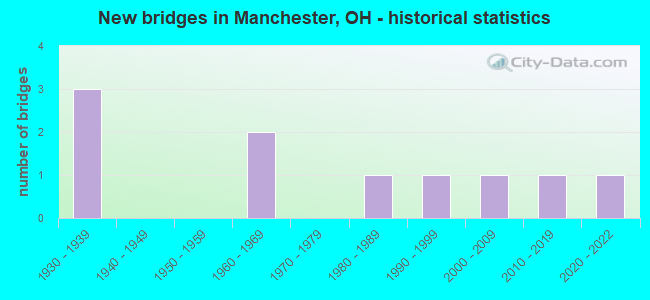
- New bridges - historical statistics
- 31930-1939
- 21960-1969
- 11980-1989
- 11990-1999
- 12000-2009
- 12010-2019
- 12020-2022

- Reconstructed bridges - Historical Statistics
- 21970-1979
- 21980-1989


- Bridge Condition - Deck
- 20.0%Excellent
- 10.0%Very good
- 40.0%Good
- 10.0%Satisfactory
- 10.0%Fair
- 10.0%Poor

- Bridge Condition - Superstructure
- 20.0%Excellent
- 10.0%Very good
- 20.0%Good
- 30.0%Satisfactory
- 10.0%Fair
- 10.0%Poor

- Bridge Condition - Substructure
- 10.0%Excellent
- 30.0%Very good
- 10.0%Good
- 30.0%Satisfactory
- 20.0%Fair

- Bridge Condition - Channel
- 10.0%Excellent
- 30.0%Very good
- 10.0%Good
- 10.0%Satisfactory
- 30.0%Fair
- 10.0%Poor
Find on map >> Show street view
Structure Number: 101842, Location: W. CORP LINE MANCHESTER,O (Lat: 38.684811, Lng: -83.621439), Route carried "on" structure: US 52, Year Built: 1998, Status: Open, Structure Length: 5.59m (18.34ft), Average Daily Traffic: 3,294 (year 2015), Truck Traffic: 10%, Average Future Daily Traffic: 4,572 (year 2035), Design Load: HS 20+Mod, Features Intersected: ISAACS CREEK
Minimum Vertical Clearance: 30+ m (98+ ft), Kilometerpoint: 10.895, Lanes on structure: 2, Base Highway Network: Yes (, Subroute: 1), Owner: State Highway Agency, Approaching Roadway Width: 9.8m (32.2ft), Material/Design: Steel continuous, Design/Construction: Stringer/Multi-beam, Number Of Spans In Main Unit: 3, Length of Maximum Span: 24.4m (80.1ft), Curb-To-Curb Width: 13.3m (43.6ft), Out-to-Out Width: 14.3m (46.9ft)
Condition: Deck: Very good, Superstructure: Good, Substructure: Very good, Channel: Very good, Operating Rating: 42.1 metric tons, Method Used To Determine Operating Rating: Load Factor (LF) rating reported by rating factor (RF) method using MS18 loading, Inventory Rating: 32.4 metric tons, Method Used To Determine Inventory Rating: Load Factor (LF) rating reported by rating factor (RF) method using MS18 loading, Structural Evaluation: Better than present minimum criteria, Deck Geometry: Equal to present minimum criteria, Waterway Adequacy: Equal to present minimum criteria, Approach Roadway Alignment: Superior to present desirable criteria, Designated Inspection Frequency: Every 24 months, Inspection Date: January 2022, Deck Structure Type: Concrete Cast-file-Place, Wearing Surface/Protective System: Wearing Surface: Monolithic Concrete, Membrane: Built-up, Deck Protection: Epoxy Coated Reinforcing
Find on map >> Show street view
Structure Number: 101869, Location: 1.19 MI. EAST OF SR 136 (Lat: 38.693711, Lng: -83.581939), Route carried "on" structure: US 52, Year Built: 1930, Year Reconstructed: 1983, Status: Open, Structure Length: 7.78m (25.52ft), Average Daily Traffic: 1,108 (year 2015), Truck Traffic: 13%, Average Future Daily Traffic: 1,538 (year 2035), Design Load: HS 20, Features Intersected: ISLAND CREEK
Minimum Vertical Clearance: 30+ m (98+ ft), Kilometerpoint: 14.484, Lanes on structure: 2, Base Highway Network: Yes (, Subroute: 1), Owner: State Highway Agency, Approaching Roadway Width: 9.8m (32.2ft), Material/Design: Steel continuous, Design/Construction: Stringer/Multi-beam, Number Of Spans In Main Unit: 3, Length of Maximum Span: 30.8m (101.0ft), Curb-To-Curb Width: 12.2m (40.0ft), Out-to-Out Width: 12.2m (40.0ft)
Condition: Deck: Satisfactory, Superstructure: Good, Substructure: Fair, Channel: Very good, Operating Rating: 42.1 metric tons, Method Used To Determine Operating Rating: Load Factor (LF) rating reported by rating factor (RF) method using MS18 loading, Inventory Rating: 32.4 metric tons, Method Used To Determine Inventory Rating: Load Factor (LF) rating reported by rating factor (RF) method using MS18 loading, Structural Evaluation: Somewhat better than minimum adequacy, Deck Geometry: Better than present minimum criteria, Waterway Adequacy: Equal to present desirable criteria, Approach Roadway Alignment: Equal to present desirable criteria, Designated Inspection Frequency: Every 12 months, Inspection Date: Febuary 2022, Deck Structure Type: Concrete Cast-file-Place, Wearing Surface/Protective System: Wearing Surface: Bituminous, Membrane: Built-up, Deck Protection: Epoxy Coated Reinforcing
Find on map >> Show street view
Structure Number: 130568, Location: AT TOOLMAKER (Lat: 38.702519, Lng: -83.582450), Route carried "on" structure: County highway C03E, Year Built: 2020, Status: Open, Structure Length: 2.26m (7.41ft), Average Daily Traffic: 550 (year 2020), Truck Traffic: 9%, Average Future Daily Traffic: 575 (year 2040), Design Load: HL 93, Features Intersected: ISLAND CREEK, Facility Carried by Structure: ISLAND CREEK ROAD
Minimum Vertical Clearance: 30+ m (98+ ft), Kilometerpoint: 1.445, Lanes on structure: 2, Owner: County Highway Agency, Approaching Roadway Width: 6.1m (20.0ft), Material/Design: Prestressed concrete, Design/Construction: Box Beam or Girders - Multiple, Number Of Spans In Main Unit: 1, Length of Maximum Span: 21.5m (70.5ft), Curb-To-Curb Width: 7.3m (24.0ft), Out-to-Out Width: 7.3m (24.0ft)
Condition: Deck: Excellent, Superstructure: Excellent, Substructure: Good, Channel: Very good, Operating Rating: 55.1 metric tons, Method Used To Determine Operating Rating: Load and Resistance Factor Rating (LRFR) rating reported by rating factor(RF) method using HL-93 loadings, Inventory Rating: 42.1 metric tons, Method Used To Determine Inventory Rating: Load and Resistance Factor Rating (LRFR) rating reported by rating factor(RF) method using HL-93 loadings, Structural Evaluation: Better than present minimum criteria, Deck Geometry: Meets minimum limits, Waterway Adequacy: Equal to present desirable criteria, Approach Roadway Alignment: Better than present minimum criteria, Length Of Structure Improvement: 2.26m (7.41ft), Designated Inspection Frequency: Every 12 months, Inspection Date: November 2021, Deck Structure Type: Concrete Precast Panels, Wearing Surface/Protective System: Wearing Surface: Bituminous, Membrane: Preformed Fabric, Deck Protection: Epoxy Coated Reinforcing
Find on map >> Show street view
Structure Number: 132226, Location: 0.001 MI FROM ISLAND CRK (Lat: 38.717769, Lng: -83.578131), Route carried "on" structure: County highway CR02J, Year Built: 2018, Status: Open, Structure Length: 2.59m (8.50ft), Average Daily Traffic: 900 (year 2017), Truck Traffic: 8%, Average Future Daily Traffic: 950 (year 2037), Design Load: HL 93, Features Intersected: ISLAND CREEK, Facility Carried by Structure: BENTONVILLE
Minimum Vertical Clearance: 30+ m (98+ ft), Kilometerpoint: 0.002, Lanes on structure: 2, Owner: County Highway Agency, Approaching Roadway Width: 7.3m (24.0ft), Material/Design: Prestressed concrete, Design/Construction: Box Beam or Girders - Multiple, Number Of Spans In Main Unit: 1, Length of Maximum Span: 25.6m (84.0ft), Curb-To-Curb Width: 7.3m (24.0ft), Out-to-Out Width: 7.3m (24.0ft)
Condition: Deck: Excellent, Superstructure: Excellent, Substructure: Excellent, Channel: Excellent, Operating Rating: 58.3 metric tons, Method Used To Determine Operating Rating: Load and Resistance Factor Rating (LRFR) rating reported by rating factor(RF) method using HL-93 loadings, Inventory Rating: 42.1 metric tons, Method Used To Determine Inventory Rating: Load and Resistance Factor Rating (LRFR) rating reported by rating factor(RF) method using HL-93 loadings, Structural Evaluation: Superior to present desirable criteria, Deck Geometry: Meets minimum limits, Waterway Adequacy: Superior to present desirable criteria, Approach Roadway Alignment: Equal to present desirable criteria, Length Of Structure Improvement: 2.68m (8.79ft), Designated Inspection Frequency: Every 24 months, Inspection Date: November 2021, Deck Structure Type: Concrete Cast-file-Place, Wearing Surface/Protective System: Wearing Surface: Monolithic Concrete, Deck Protection: Epoxy Coated Reinforcing
Find on map >> Show street view
Structure Number: 132357, Location: 0.38 MI W OF SR 136 (Lat: 38.700111, Lng: -83.610661), Route carried "on" structure: County highway C03D, Year Built: 1930, Year Reconstructed: 1981, Status: Open, Structure Length: 0.88m (2.89ft), Average Daily Traffic: 398 (year 2015), Truck Traffic: 8%, Average Future Daily Traffic: 552 (year 2035), Design Load: HS 20, Features Intersected: STREAM, Facility Carried by Structure: BROWN HILL ROAD
Minimum Vertical Clearance: 30+ m (98+ ft), Kilometerpoint: 0.621, Lanes on structure: 1, Owner: County Highway Agency, Approaching Roadway Width: 4.9m (16.1ft), Material/Design: Concrete, Design/Construction: Slab, Number Of Spans In Main Unit: 1, Length of Maximum Span: 8.2m (26.9ft), Curb-To-Curb Width: 6.1m (20.0ft), Out-to-Out Width: 6.7m (22.0ft)
Condition: Deck: Poor, Superstructure: Poor, Substructure: Satisfactory, Channel: Fair, Operating Rating: 39.0 metric tons, Method Used To Determine Operating Rating: Field evaluation and documented engineering judgment, Inventory Rating: 27.2 metric tons, Method Used To Determine Inventory Rating: Field evaluation and documented engineering judgment, Structural Evaluation: Meets minimum limits, Deck Geometry: Meets minimum limits, Waterway Adequacy: Equal to present minimum criteria, Approach Roadway Alignment: Equal to present desirable criteria, Designated Inspection Frequency: Every 12 months, Inspection Date: November 2021, Deck Structure Type: Concrete Cast-file-Place, Wearing Surface/Protective System: Wearing Surface: Bituminous
Find on map >> Show street view
Structure Number: 132373, Location: 1.45 MI W OF SR 136 (Lat: 38.697389, Lng: -83.608269), Route carried "on" structure: County highway C03D, Year Built: 1930, Status: Open, Structure Length: 0.73m (2.40ft), Average Daily Traffic: 398 (year 2015), Truck Traffic: 8%, Average Future Daily Traffic: 552 (year 2035), Design Load: H 20, Features Intersected: STREAM, Facility Carried by Structure: BROWN HILL RD.
Minimum Vertical Clearance: 30+ m (98+ ft), Kilometerpoint: 0.233, Lanes on structure: 1, Owner: County Highway Agency, Approaching Roadway Width: 4.9m (16.1ft), Material/Design: Concrete, Design/Construction: Slab, Number Of Spans In Main Unit: 1, Length of Maximum Span: 6.7m (22.0ft), Curb-To-Curb Width: 6.1m (20.0ft), Out-to-Out Width: 6.7m (22.0ft)
Condition: Deck: Fair, Superstructure: Fair, Substructure: Fair, Channel: Fair, Operating Rating: 40.8 metric tons, Method Used To Determine Operating Rating: Field evaluation and documented engineering judgment, Inventory Rating: 32.7 metric tons, Method Used To Determine Inventory Rating: Field evaluation and documented engineering judgment, Structural Evaluation: Somewhat better than minimum adequacy, Deck Geometry: Meets minimum limits, Waterway Adequacy: Equal to present minimum criteria, Approach Roadway Alignment: Equal to present desirable criteria, Designated Inspection Frequency: Every 12 months, Inspection Date: November 2021, Deck Structure Type: Concrete Cast-file-Place, Wearing Surface/Protective System: Wearing Surface: Bituminous
Find on map >> Show street view
Structure Number: 132403, Location: JUST WEST OF JCT SR 136 (Lat: 38.696739, Lng: -83.606900), Route carried "on" structure: County highway C03D, Year Built: 1960, Year Reconstructed: 1980, Status: Open, Structure Length: 2.01m (6.59ft), Average Daily Traffic: 398 (year 2015), Truck Traffic: 8%, Average Future Daily Traffic: 552 (year 2035), Features Intersected: ISAACS CREEK, Facility Carried by Structure: BROWN HILL ROAD
Minimum Vertical Clearance: 30+ m (98+ ft), Kilometerpoint: 0.097, Lanes on structure: 2, Owner: County Highway Agency, Approaching Roadway Width: 4.9m (16.1ft), Material/Design: Steel, Design/Construction: Stringer/Multi-beam, Number Of Spans In Main Unit: 1, Length of Maximum Span: 17.1m (56.1ft), Curb-To-Curb Width: 6.1m (20.0ft), Out-to-Out Width: 6.1m (20.0ft)
Condition: Deck: Good, Superstructure: Satisfactory, Substructure: Satisfactory, Channel: Fair, Operating Rating: 42.1 metric tons, Method Used To Determine Operating Rating: Allowable Stress (AS) rating reported by rating factor (RF) method using MS18 loading, Inventory Rating: 32.4 metric tons, Method Used To Determine Inventory Rating: Allowable Stress (AS) rating reported by rating factor (RF) method using MS18 loading, Structural Evaluation: Equal to present minimum criteria, Deck Geometry: Meets minimum limits, Waterway Adequacy: Better than present minimum criteria, Approach Roadway Alignment: Better than present minimum criteria, Designated Inspection Frequency: Every 12 months, Inspection Date: November 2021, Deck Structure Type: Corrugated Steel, Wearing Surface/Protective System: Wearing Surface: Bituminous
Find on map >> Show street view
Structure Number: 133701, Location: JUST SOUTH OF JCT SR 41 (Lat: 38.706611, Lng: -83.647119), Route carried "on" structure: County highway C20B, Year Built: 1988, Status: Open, Structure Length: 1.71m (5.61ft), Average Daily Traffic: 306 (year 2015), Truck Traffic: 7%, Average Future Daily Traffic: 425 (year 2035), Design Load: HS 20, Features Intersected: BIG THREE MILE CREEK, Facility Carried by Structure: ROUSH HILL ROAD
Minimum Vertical Clearance: 30+ m (98+ ft), Kilometerpoint: 4.566, Lanes on structure: 2, Owner: County Highway Agency, Approaching Roadway Width: 6.7m (22.0ft), Material/Design: Steel, Design/Construction: Stringer/Multi-beam, Number Of Spans In Main Unit: 1, Length of Maximum Span: 16.2m (53.1ft), Curb-To-Curb Width: 8.5m (27.9ft), Out-to-Out Width: 8.5m (27.9ft)
Condition: Deck: Good, Superstructure: Very good, Substructure: Very good, Channel: Poor, Operating Rating: 32.4 metric tons, Method Used To Determine Operating Rating: Load and Resistance Factor Rating (LRFR) rating reported by rating factor(RF) method using HL-93 loadings, Inventory Rating: 22.7 metric tons, Method Used To Determine Inventory Rating: Load and Resistance Factor Rating (LRFR) rating reported by rating factor(RF) method using HL-93 loadings, Structural Evaluation: Equal to present minimum criteria, Deck Geometry: Equal to present minimum criteria, Waterway Adequacy: Better than present minimum criteria, Approach Roadway Alignment: Better than present minimum criteria, Designated Inspection Frequency: Every 24 months, Inspection Date: November 2020, Deck Structure Type: Concrete Cast-file-Place, Wearing Surface/Protective System: Wearing Surface: Bituminous
Find on map >> Show street view
Structure Number: 135127, Location: SOUTH OF JCT SR 41 (Lat: 38.690381, Lng: -83.675381), Route carried "on" structure: County highway T02C, Year Built: 1965, Year Reconstructed: 1989, Status: Posted for load, Structure Length: 1.22m (4.00ft), Average Daily Traffic: 128 (year 2015), Truck Traffic: 8%, Average Future Daily Traffic: 178 (year 2035), Features Intersected: BIG THREE MILE CREEK, Facility Carried by Structure: CONNORS HOLLOW RD
Minimum Vertical Clearance: 30+ m (98+ ft), Kilometerpoint: 0.008, Lanes on structure: 1, Owner: County Highway Agency, Approaching Roadway Width: 3.7m (12.1ft), Material/Design: Steel continuous, Design/Construction: Stringer/Multi-beam, Number Of Spans In Main Unit: 2, Length of Maximum Span: 5.5m (18.0ft), Curb-To-Curb Width: 4.9m (16.1ft), Out-to-Out Width: 4.9m (16.1ft)
Condition: Deck: Good, Superstructure: Satisfactory, Substructure: Satisfactory, Channel: Good, Operating Rating: 32.4 metric tons, Method Used To Determine Operating Rating: Allowable Stress (AS) rating reported by rating factor (RF) method using MS18 loading, Inventory Rating: 22.7 metric tons, Method Used To Determine Inventory Rating: Allowable Stress (AS) rating reported by rating factor (RF) method using MS18 loading, Structural Evaluation: Equal to present minimum criteria, Deck Geometry: High priority of replacement, Waterway Adequacy: Better than present minimum criteria, Approach Roadway Alignment: Better than present minimum criteria, Bridge Posting: Required (Relationship of Operating Rating to Maximum Legal Load: 0.1 - 9.9% below), Designated Inspection Frequency: Every 12 months, Inspection Date: November 2021, Deck Structure Type: Wood or Timber, Wearing Surface/Protective System: Wearing Surface: Wood or Timber
Find on map >> Show street view
Structure Number: 139106, Location: JUST NORTH OF US52 (Lat: 38.688339, Lng: -83.622461), Route carried "on" structure: County highway T-8-8, Year Built: 2001, Status: Open, Structure Length: 0.85m (2.79ft), Average Daily Traffic: 351 (year 2015), Truck Traffic: 7%, Average Future Daily Traffic: 487 (year 2035), Design Load: HS 20, Features Intersected: STREAM, Facility Carried by Structure: YATES ROAD
Minimum Vertical Clearance: 30+ m (98+ ft), Kilometerpoint: 0.901, Lanes on structure: 2, Owner: County Highway Agency, Approaching Roadway Width: 7.9m (25.9ft), Skew: 1 degrees, Material/Design: Steel, Design/Construction: Stringer/Multi-beam, Number Of Spans In Main Unit: 1, Length of Maximum Span: 7.3m (24.0ft), Curb-To-Curb Width: 7.3m (24.0ft), Out-to-Out Width: 7.3m (24.0ft)
Condition: Deck: Good, Superstructure: Satisfactory, Substructure: Very good, Channel: Satisfactory, Operating Rating: 97.2 metric tons, Method Used To Determine Operating Rating: Allowable Stress (AS) rating reported by rating factor (RF) method using MS18 loading, Inventory Rating: 74.5 metric tons, Method Used To Determine Inventory Rating: Allowable Stress (AS) rating reported by rating factor (RF) method using MS18 loading, Structural Evaluation: Equal to present minimum criteria, Deck Geometry: Somewhat better than minimum adequacy, Waterway Adequacy: Better than present minimum criteria, Approach Roadway Alignment: Superior to present desirable criteria, Designated Inspection Frequency: Every 12 months, Inspection Date: November 2021, Deck Structure Type: Corrugated Steel, Wearing Surface/Protective System: Wearing Surface: Bituminous