Bridge Statistics for Manitou Springs, Colorado (CO)
Condition, Traffic, Stress, Structural Evaluation, Project Costs
- National Bridge Inventory (NBI) Statistics
- 20Number of bridges
- 203ft / 61.8mTotal length
- $3,100,000Total costs
- 266,350Total average daily traffic
- 9,669Total average daily truck traffic
- National Bridge Inventory (NBI) Registered Bridges for Manitou Springs
- No street view available for this location
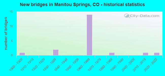
- New bridges - historical statistics
- 11900-1909
- 21930-1939
- 141960-1969
- 11980-1989
- 12010-2019
- 12020-2022


- Bridge Condition - Deck
- 7.7%Very good
- 38.5%Satisfactory
- 53.8%Fair

- Bridge Condition - Superstructure
- 7.7%Very good
- 30.8%Good
- 53.8%Satisfactory
- 7.7%Fair

- Bridge Condition - Substructure
- 15.4%Very good
- 7.7%Good
- 76.9%Satisfactory

- Bridge Condition - Channel
- 63.6%Very good
- 36.4%Satisfactory

- Bridge Condition - Culverts
- 25.0%Good
- 50.0%Fair
- 25.0%Poor
Find on map >> Show street view
Structure Number: I-17-AF, Location: 2.6 MI SE OF PIKES PEAK-T (Lat: 38.876500, Lng: -104.937625), Route carried "on" structure: US 24A, Year Built: 1965, Status: Open, Structure Length: 1.00m (3.28ft), Average Daily Traffic: 11,500 (year 2020), Truck Traffic: 4%, Average Future Daily Traffic: 13,225 (year 2040), Design Load: HS 20, Features Intersected: FOUNTAIN CREEK, Facility Carried by Structure: US 24 ML EBND
Minimum Vertical Clearance: 30+ m (98+ ft), Kilometerpoint: 244.801, Lanes on structure: 2, Base Highway Network: Yes, Owner: State Highway Agency, Approaching Roadway Width: 9.1m (29.9ft), Skew: 15 degrees, Material/Design: Concrete, Design/Construction: Culvert, Number Of Spans In Main Unit: 2, Length of Maximum Span: 4.7m (15.4ft), Curb-To-Curb Width: 9.1m (29.9ft), Out-to-Out Width: 15.2m (49.9ft)
Condition: Channel: Satisfactory, Culverts: Fair, Structural Evaluation: Somewhat better than minimum adequacy, Deck Geometry: Meets minimum limits, Waterway Adequacy: Equal to present desirable criteria, Approach Roadway Alignment: Equal to present desirable criteria, Designated Inspection Frequency: Every 24 months, Inspection Date: January 2021
Find on map >> Show street view
Structure Number: I-17-AI, Location: SOUTH OF CASCADE (Lat: 38.870358, Lng: -104.925903), Route carried "on" structure: Business US 24E, Year Built: 1932, Status: Open, Structure Length: 6.40m (21.00ft), Average Daily Traffic: 1,300 (year 2020), Truck Traffic: 5%, Average Future Daily Traffic: 1,456 (year 2040), Design Load: H 20, Features Intersected: FOUNTAIN CREEK, Facility Carried by Structure: US 24 BUSINESS RT
Minimum Vertical Clearance: 30+ m (98+ ft), Kilometerpoint: 0.249, Lanes on structure: 2, Base Highway Network: Yes, Owner: State Highway Agency, Approaching Roadway Width: 11.0m (36.1ft), Material/Design: Concrete, Design/Construction: Arch - Deck, Number Of Spans In Main Unit: 1, Number Of Approach Spans: 3, Length of Maximum Span: 49.4m (162.1ft), Curb-To-Curb Width: 11.0m (36.1ft), Out-to-Out Width: 12.0m (39.4ft)
Condition: Deck: Satisfactory, Superstructure: Satisfactory, Substructure: Satisfactory, Channel: Very good, Operating Rating: 68.1 metric tons, Method Used To Determine Operating Rating: Load Factor (LF), Inventory Rating: 37.2 metric tons, Method Used To Determine Inventory Rating: Load Factor (LF), Structural Evaluation: Equal to present minimum criteria, Deck Geometry: Equal to present minimum criteria, Waterway Adequacy: Superior to present desirable criteria, Approach Roadway Alignment: Equal to present minimum criteria, Designated Inspection Frequency: Every 24 months, Inspection Date: January 2021, Deck Structure Type: Concrete Cast-file-Place, Wearing Surface/Protective System: Wearing Surface: Bituminous
Find on map >> Show street view
Structure Number: I-17-GD, Location: 0.3 MI NW OF JCT COLO AVE (Lat: 38.856500, Lng: -104.890964), Route carried "on" structure: US 24A, Year Built: 1967, Status: Open, Structure Length: 3.93m (12.89ft), Average Daily Traffic: 21,500 (year 2020), Truck Traffic: 3%, Average Future Daily Traffic: 27,305 (year 2040), Design Load: HS 20+Mod, Features Intersected: CRYSTAL HILLS BLVD, Facility Carried by Structure: US 24 ML WBND
Minimum Vertical Clearance: 30+ m (98+ ft), Kilometerpoint: 249.833, Lanes on structure: 2, Lanes under structure: 2, Base Highway Network: Yes, Owner: State Highway Agency, Approaching Roadway Width: 12.2m (40.0ft), Skew: 10 degrees, Material/Design: Concrete continuous, Design/Construction: Tee Beam, Number Of Spans In Main Unit: 3, Length of Maximum Span: 17.4m (57.1ft), Curb-To-Curb Width: 10.9m (35.8ft), Out-to-Out Width: 11.7m (38.4ft)
Condition: Deck: Fair, Superstructure: Good, Substructure: Good, Operating Rating: 50.8 metric tons, Method Used To Determine Operating Rating: Load Factor (LF), Inventory Rating: 30.8 metric tons, Method Used To Determine Inventory Rating: Load Factor (LF), Structural Evaluation: Better than present minimum criteria, Deck Geometry: Meets minimum limits, Underclear: Meets minimum limits, Approach Roadway Alignment: Equal to present desirable criteria, Designated Inspection Frequency: Every 24 months, Inspection Date: January 2021, Deck Structure Type: Concrete Cast-file-Place, Wearing Surface/Protective System: Wearing Surface: Bituminous
Find on map >> Show street view
Structure Number: I-17-GE, Location: IN MANITOU SPRINGS (Lat: 38.856386, Lng: -104.890967), Route carried "on" structure: US 24A, Year Built: 1967, Status: Open, Structure Length: 3.93m (12.89ft), Average Daily Traffic: 21,500 (year 2020), Truck Traffic: 3%, Average Future Daily Traffic: 27,305 (year 2040), Design Load: HS 20+Mod, Features Intersected: CRYSTAL HILLS BLVD, Facility Carried by Structure: US 24 ML EBND
Minimum Vertical Clearance: 30+ m (98+ ft), Kilometerpoint: 249.836, Lanes on structure: 2, Lanes under structure: 2, Base Highway Network: Yes, Owner: State Highway Agency, Approaching Roadway Width: 12.2m (40.0ft), Skew: 11 degrees, Material/Design: Concrete continuous, Design/Construction: Tee Beam, Number Of Spans In Main Unit: 3, Length of Maximum Span: 17.4m (57.1ft), Curb-To-Curb Width: 11.3m (37.1ft), Out-to-Out Width: 11.7m (38.4ft)
Condition: Deck: Fair, Superstructure: Satisfactory, Substructure: Satisfactory, Operating Rating: 55.3 metric tons, Method Used To Determine Operating Rating: Load Factor (LF), Inventory Rating: 32.7 metric tons, Method Used To Determine Inventory Rating: Load Factor (LF), Structural Evaluation: Equal to present minimum criteria, Deck Geometry: Somewhat better than minimum adequacy, Underclear: Somewhat better than minimum adequacy, Approach Roadway Alignment: Equal to present desirable criteria, Designated Inspection Frequency: Every 24 months, Inspection Date: January 2021, Deck Structure Type: Concrete Cast-file-Place, Wearing Surface/Protective System: Wearing Surface: Bituminous
Find on map >> Show street view
Structure Number: I-17-GF, Location: IN MANITOU SPRINGS (Lat: 38.859242, Lng: -104.897772), Route carried "on" structure: US 24A, Year Built: 1969, Status: Open, Structure Length: 6.25m (20.51ft), Average Daily Traffic: 13,500 (year 2020), Truck Traffic: 4%, Average Future Daily Traffic: 16,200 (year 2040), Design Load: HS 20, Features Intersected: EL PASO BLV,FOUNTAIN CRK, Facility Carried by Structure: US 24 ML WBND
Minimum Vertical Clearance: 30+ m (98+ ft), Kilometerpoint: 249.151, Lanes on structure: 3, Lanes under structure: 2, Base Highway Network: Yes, Owner: State Highway Agency, Approaching Roadway Width: 11.6m (38.1ft), Skew: 10 degrees, Material/Design: Prestressed concrete, Design/Construction: Stringer/Multi-beam, Number Of Spans In Main Unit: 2, Length of Maximum Span: 30.2m (99.1ft), Curb-To-Curb Width: 12.6m (41.3ft), Out-to-Out Width: 13.6m (44.6ft)
Condition: Deck: Satisfactory, Superstructure: Satisfactory, Substructure: Satisfactory, Channel: Very good, Operating Rating: 58.9 metric tons, Method Used To Determine Operating Rating: Load Factor (LF), Inventory Rating: 29.1 metric tons, Method Used To Determine Inventory Rating: Load Factor (LF), Structural Evaluation: Equal to present minimum criteria, Deck Geometry: Meets minimum limits, Underclear: Superior to present desirable criteria, Waterway Adequacy: Superior to present desirable criteria, Approach Roadway Alignment: Equal to present desirable criteria, Designated Inspection Frequency: Every 24 months, Inspection Date: January 2021, Deck Structure Type: Concrete Cast-file-Place, Wearing Surface/Protective System: Wearing Surface: Bituminous
Find on map >> Show street view
Structure Number: I-17-GG, Location: IN MANITOU SPRINGS (Lat: 38.859136, Lng: -104.897886), Route carried "on" structure: US 24A, Year Built: 1969, Status: Open, Structure Length: 6.25m (20.51ft), Average Daily Traffic: 13,500 (year 2020), Truck Traffic: 4%, Average Future Daily Traffic: 16,200 (year 2040), Design Load: HS 20, Features Intersected: EL PASO BLV,FOUNTAIN CRK, Facility Carried by Structure: US 24 ML EBND
Minimum Vertical Clearance: 30+ m (98+ ft), Kilometerpoint: 249.149, Lanes on structure: 2, Lanes under structure: 2, Base Highway Network: Yes, Owner: State Highway Agency, Approaching Roadway Width: 11.6m (38.1ft), Skew: 10 degrees, Material/Design: Prestressed concrete, Design/Construction: Stringer/Multi-beam, Number Of Spans In Main Unit: 2, Length of Maximum Span: 30.2m (99.1ft), Curb-To-Curb Width: 11.0m (36.1ft), Out-to-Out Width: 11.9m (39.0ft)
Condition: Deck: Fair, Superstructure: Satisfactory, Substructure: Satisfactory, Channel: Very good, Operating Rating: 45.5 metric tons, Method Used To Determine Operating Rating: Load Factor (LF), Inventory Rating: 27.4 metric tons, Method Used To Determine Inventory Rating: Load Factor (LF), Structural Evaluation: Equal to present minimum criteria, Deck Geometry: Somewhat better than minimum adequacy, Underclear: Equal to present minimum criteria, Waterway Adequacy: Superior to present desirable criteria, Approach Roadway Alignment: Equal to present desirable criteria, Designated Inspection Frequency: Every 24 months, Inspection Date: January 2021, Deck Structure Type: Concrete Cast-file-Place, Wearing Surface/Protective System: Wearing Surface: Bituminous
Find on map >> Show street view
Structure Number: I-17-GH, Location: IN MANITOU SPRINGS (Lat: 38.858619, Lng: -104.897872), Route carried "on" structure: ServiceUS 24A, Year Built: 1969, Status: Open, Structure Length: 3.20m (10.50ft), Average Daily Traffic: 27,000 (year 2020), Truck Traffic: 4%, Average Future Daily Traffic: 32,400 (year 2040), Design Load: HS 20, Features Intersected: FOUNTAIN CREEK SR, Facility Carried by Structure: US 24 SERVICE RD
Minimum Vertical Clearance: 30+ m (98+ ft), Kilometerpoint: 0.011, Lanes on structure: 2, Base Highway Network: Yes, Owner: State Highway Agency, Approaching Roadway Width: 8.8m (28.9ft), Skew: 3 degrees, Material/Design: Prestressed concrete, Design/Construction: Stringer/Multi-beam, Number Of Spans In Main Unit: 1, Length of Maximum Span: 30.2m (99.1ft), Curb or Sidewalk Widths: Left: 0.0m, Right: 1.4m (4.6ft), Curb-To-Curb Width: 8.8m (28.9ft), Out-to-Out Width: 10.7m (35.1ft)
Condition: Deck: Fair, Superstructure: Good, Substructure: Satisfactory, Channel: Very good, Operating Rating: 58.4 metric tons, Method Used To Determine Operating Rating: Load Factor (LF), Inventory Rating: 32.4 metric tons, Method Used To Determine Inventory Rating: Load Factor (LF), Structural Evaluation: Equal to present minimum criteria, Deck Geometry: High priority of replacement, Waterway Adequacy: Equal to present desirable criteria, Approach Roadway Alignment: Equal to present desirable criteria, Length Of Structure Improvement: 3.20m (10.50ft), Designated Inspection Frequency: Every 24 months, Inspection Date: January 2021, Bridge Improvement Cost: $502,000, Roadway Improvement Cost: $50,000, Total Project Cost: $553,000 ( Estimate for 2018), Deck Structure Type: Concrete Cast-file-Place, Wearing Surface/Protective System: Wearing Surface: Monolithic Concrete
Find on map >> Show street view
Structure Number: I-17-GI, Location: 1.0 MI NW OF JCT COLO AVE (Lat: 38.858306, Lng: -104.896225), Route carried "on" structure: Business US 24A, Year Built: 1969, Status: Open, Structure Length: 5.52m (18.11ft), Average Daily Traffic: 13,500 (year 2020), Truck Traffic: 4%, Average Future Daily Traffic: 16,200 (year 2040), Design Load: HS 20, Features Intersected: US 24 BUSS RT, Facility Carried by Structure: US 24 ML WBND
Minimum Vertical Clearance: 30+ m (98+ ft), Kilometerpoint: 249.321, Lanes on structure: 3, Lanes under structure: 5, Base Highway Network: Yes, Owner: State Highway Agency, Approaching Roadway Width: 12.2m (40.0ft), Skew: 11 degrees, Material/Design: Prestressed concrete, Design/Construction: Stringer/Multi-beam, Number Of Spans In Main Unit: 2, Length of Maximum Span: 27.0m (88.6ft), Curb-To-Curb Width: 12.8m (42.0ft), Out-to-Out Width: 13.6m (44.6ft)
Condition: Deck: Fair, Superstructure: Good, Substructure: Satisfactory, Operating Rating: 66.2 metric tons, Method Used To Determine Operating Rating: Load Factor (LF), Inventory Rating: 37.7 metric tons, Method Used To Determine Inventory Rating: Load Factor (LF), Structural Evaluation: Equal to present minimum criteria, Deck Geometry: High priority of replacement, Underclear: Equal to present minimum criteria, Approach Roadway Alignment: Equal to present desirable criteria, Length Of Structure Improvement: 5.52m (18.11ft), Designated Inspection Frequency: Every 24 months, Inspection Date: January 2021, Bridge Improvement Cost: $666,000, Roadway Improvement Cost: $67,000, Total Project Cost: $733,000 ( Estimate for 2018), Deck Structure Type: Concrete Cast-file-Place, Wearing Surface/Protective System: Wearing Surface: Bituminous
Find on map >> Show street view
Structure Number: I-17-GJ, Location: IN MANITOU SPRINGS (Lat: 38.858217, Lng: -104.896350), Route carried "on" structure: Business US 24A, Year Built: 1969, Status: Open, Structure Length: 5.52m (18.11ft), Average Daily Traffic: 13,500 (year 2020), Truck Traffic: 4%, Average Future Daily Traffic: 16,200 (year 2040), Design Load: HS 20, Features Intersected: US 24 BUSS RT, Facility Carried by Structure: US 24 ML EBND
Minimum Vertical Clearance: 30+ m (98+ ft), Kilometerpoint: 249.318, Lanes on structure: 2, Lanes under structure: 6, Base Highway Network: Yes, Owner: State Highway Agency, Approaching Roadway Width: 11.6m (38.1ft), Skew: 11 degrees, Material/Design: Prestressed concrete, Design/Construction: Stringer/Multi-beam, Number Of Spans In Main Unit: 2, Length of Maximum Span: 27.1m (88.9ft), Curb-To-Curb Width: 11.0m (36.1ft), Out-to-Out Width: 11.7m (38.4ft)
Condition: Deck: Fair, Superstructure: Good, Substructure: Satisfactory, Operating Rating: 69.1 metric tons, Method Used To Determine Operating Rating: Load Factor (LF), Inventory Rating: 41.4 metric tons, Method Used To Determine Inventory Rating: Load Factor (LF), Structural Evaluation: Equal to present minimum criteria, Deck Geometry: Somewhat better than minimum adequacy, Underclear: Meets minimum limits, Approach Roadway Alignment: Equal to present desirable criteria, Designated Inspection Frequency: Every 24 months, Inspection Date: January 2021, Deck Structure Type: Concrete Cast-file-Place, Wearing Surface/Protective System: Wearing Surface: Bituminous
Find on map >> Show street view
Structure Number: I-17-GL, Location: 3.4 MI SE OF PIKES PEAK-T (Lat: 38.870989, Lng: -104.925978), Route carried "on" structure: Business US 24A, Year Built: 1969, Status: Open, Structure Length: 3.87m (12.70ft), Average Daily Traffic: 23,000 (year 2020), Truck Traffic: 4%, Average Future Daily Traffic: 26,450 (year 2040), Design Load: HS 20, Features Intersected: US 24 BUSS RT, Facility Carried by Structure: US 24 ML
Minimum Vertical Clearance: 30+ m (98+ ft), Kilometerpoint: 246.159, Lanes on structure: 4, Lanes under structure: 1, Base Highway Network: Yes, Owner: State Highway Agency, Approaching Roadway Width: 21.3m (69.9ft), Skew: 33 degrees, Material/Design: Prestressed concrete, Design/Construction: Stringer/Multi-beam, Number Of Spans In Main Unit: 1, Number Of Approach Spans: 1, Length of Maximum Span: 29.6m (97.1ft), Curb-To-Curb Width: 21.3m (69.9ft), Out-to-Out Width: 22.7m (74.5ft)
Condition: Deck: Satisfactory, Superstructure: Satisfactory, Substructure: Satisfactory, Operating Rating: 35.3 metric tons, Method Used To Determine Operating Rating: Load Factor (LF), Inventory Rating: 31.8 metric tons, Method Used To Determine Inventory Rating: Load Factor (LF), Structural Evaluation: Equal to present minimum criteria, Deck Geometry: Better than present minimum criteria, Underclear: Meets minimum limits, Approach Roadway Alignment: Equal to present desirable criteria, Designated Inspection Frequency: Every 24 months, Inspection Date: January 2021, Deck Structure Type: Concrete Cast-file-Place, Wearing Surface/Protective System: Wearing Surface: Bituminous
Find on map >> Show street view
Structure Number: I-17-GN, Location: IN MANITOU SPRINGS (Lat: 38.863400, Lng: -104.917389), Route carried "on" structure: US 24A, Year Built: 1969, Year Reconstructed: 1997, Status: Open, Structure Length: 10.49m (34.42ft), Average Daily Traffic: 27,000 (year 2020), Truck Traffic: 4%, Average Future Daily Traffic: 32,400 (year 2040), Design Load: HS 20, Features Intersected: WILLIAMS CANYON, RDWY, Facility Carried by Structure: US 24 ML
Minimum Vertical Clearance: 30+ m (98+ ft), Kilometerpoint: 247.295, Lanes on structure: 4, Lanes under structure: 2, Base Highway Network: Yes, Owner: State Highway Agency, Approaching Roadway Width: 21.3m (69.9ft), Skew: 20 degrees, Material/Design: Steel continuous, Design/Construction: Stringer/Multi-beam, Number Of Spans In Main Unit: 3, Length of Maximum Span: 51.8m (169.9ft), Curb-To-Curb Width: 21.3m (69.9ft), Out-to-Out Width: 22.7m (74.5ft)
Condition: Deck: Satisfactory, Superstructure: Satisfactory, Substructure: Satisfactory, Operating Rating: 41.7 metric tons, Method Used To Determine Operating Rating: Load Factor (LF), Inventory Rating: 25.0 metric tons, Method Used To Determine Inventory Rating: Load Factor (LF), Structural Evaluation: Equal to present minimum criteria, Deck Geometry: Better than present minimum criteria, Underclear: Superior to present desirable criteria, Approach Roadway Alignment: Equal to present desirable criteria, Designated Inspection Frequency: Every 24 months, Other Special Inspection Frequency: Every 60 months, Inspection Date: May 2020, Other Special Inspection Date: August 2017, Deck Structure Type: Concrete Cast-file-Place, Wearing Surface/Protective System: Wearing Surface: Other, Membrane: Other, Deck Protection: Epoxy Coated Reinforcing
Find on map >> Show street view
Structure Number: I-17-IH, Location: .6 MI W OF JCT 24 BUS. RT (Lat: 38.876394, Lng: -104.932497), Route carried "on" structure: US 24A, Year Built: 2014, Status: Open, Structure Length: 0.84m (2.76ft), Average Daily Traffic: 23,000 (year 2020), Truck Traffic: 4%, Average Future Daily Traffic: 26,450 (year 2040), Design Load: HL 93, Features Intersected: WALDO CANYON, Facility Carried by Structure: US24 ML
Minimum Vertical Clearance: 30+ m (98+ ft), Kilometerpoint: 245.269, Lanes on structure: 4, Base Highway Network: Yes, Owner: State Highway Agency, Approaching Roadway Width: 19.5m (64.0ft), Skew: 33 degrees, Material/Design: Concrete, Design/Construction: Culvert, Number Of Spans In Main Unit: 1, Length of Maximum Span: 8.4m (27.6ft), Out-to-Out Width: 34.1m (111.9ft)
Condition: Channel: Very good, Culverts: Good, Operating Rating: 42.1 metric tons, Method Used To Determine Operating Rating: Load and Resistance Factor Rating (LRFR) rating reported by rating factor(RF) method using HL-93 loadings, Inventory Rating: 32.4 metric tons, Method Used To Determine Inventory Rating: Load and Resistance Factor Rating (LRFR) rating reported by rating factor(RF) method using HL-93 loadings, Structural Evaluation: Better than present minimum criteria, Waterway Adequacy: Better than present minimum criteria, Approach Roadway Alignment: Equal to present desirable criteria, Designated Inspection Frequency: Every 24 months, Inspection Date: January 2021
Find on map >> Show street view
Structure Number: I-17-X, Location: 1.7 MI SE OF PIKES PEAK-T (Lat: 38.881861, Lng: -104.950036), Route carried "on" structure: ServiceUS 24A, Year Built: 1965, Status: Open, Structure Length: 0.64m (2.10ft), Average Daily Traffic: 23,000 (year 2020), Truck Traffic: 4%, Average Future Daily Traffic: 26,450 (year 2040), Design Load: HS 20, Features Intersected: FOUNTAIN CREEK SR, Facility Carried by Structure: US 24 SERVICE RD
Minimum Vertical Clearance: 30+ m (98+ ft), Kilometerpoint: 0.037, Lanes on structure: 2, Base Highway Network: Yes, Owner: State Highway Agency, Approaching Roadway Width: 8.5m (27.9ft), Material/Design: Concrete, Design/Construction: Culvert, Number Of Spans In Main Unit: 2, Length of Maximum Span: 3.0m (9.8ft), Curb-To-Curb Width: 8.5m (27.9ft), Out-to-Out Width: 13.4m (44.0ft)
Condition: Channel: Satisfactory, Culverts: Poor, Operating Rating: 36.3 metric tons, Method Used To Determine Operating Rating: Field evaluation and documented engineering judgment, Inventory Rating: 32.7 metric tons, Method Used To Determine Inventory Rating: Field evaluation and documented engineering judgment, Structural Evaluation: Meets minimum limits, Deck Geometry: High priority of replacement, Waterway Adequacy: Equal to present desirable criteria, Approach Roadway Alignment: Meets minimum limits, Designated Inspection Frequency: Every 24 months, Inspection Date: January 2021
Find on map >> Show street view
Structure Number: MAN-BECKERS, Location: 150 FT N OF MANITOU AVE (Lat: 38.858172, Lng: -104.891411), Route carried "on" structure: City street , Year Built: 2021, Status: Not yet open, Structure Length: 1.22m (4.00ft), Average Daily Traffic: 1,622 (year 2017), Average Future Daily Traffic: 2,000 (year 2027), Design Load: HL 93, Features Intersected: FOUNTAIN CREEK, Facility Carried by Structure: BECKERS LANE
Minimum Vertical Clearance: 30+ m (98+ ft), Kilometerpoint: 0.058, Lanes on structure: 2, Owner: City or Municipal Highway Agency, Approaching Roadway Width: 7.3m (24.0ft), Material/Design: Prestressed concrete, Design/Construction: Box Beam or Girders - Multiple, Number Of Spans In Main Unit: 1, Length of Maximum Span: 10.7m (35.1ft), Curb or Sidewalk Widths: Left: 1.4m (4.6ft), Right: 2.0m (6.6ft), Curb-To-Curb Width: 7.3m (24.0ft), Out-to-Out Width: 11.6m (38.1ft)
Condition: Deck: Very good, Superstructure: Very good, Substructure: Very good, Channel: Very good, Operating Rating: 44.1 metric tons, Method Used To Determine Operating Rating: Load and Resistance Factor Rating (LRFR) rating reported by rating factor(RF) method using HL-93 loadings, Inventory Rating: 24.6 metric tons, Method Used To Determine Inventory Rating: Load and Resistance Factor Rating (LRFR) rating reported by rating factor(RF) method using HL-93 loadings, Structural Evaluation: Equal to present minimum criteria, Deck Geometry: Meets minimum limits, Waterway Adequacy: Equal to present desirable criteria, Approach Roadway Alignment: Equal to present desirable criteria, Designated Inspection Frequency: Every 24 months, Inspection Date: July 2021, Deck Structure Type: Concrete Cast-file-Place, Wearing Surface/Protective System: Wearing Surface: Bituminous, Membrane: Epoxy
Find on map >> Show street view
Structure Number: MANITOU-CANON, Location: .1 MI N OF MANITOU AVENUE (Lat: 38.858442, Lng: -104.916689), Route carried "on" structure: City street , Year Built: 1906, Year Reconstructed: 1990, Status: Open, Structure Length: 0.67m (2.20ft), Average Daily Traffic: 1,195 (year 2020), Truck Traffic: 1%, Average Future Daily Traffic: 1,566 (year 2040), Features Intersected: FOUNTAIN CREEK, Facility Carried by Structure: CANON AVE
Minimum Vertical Clearance: 30+ m (98+ ft), Kilometerpoint: 0.133, Lanes on structure: 1, Owner: City or Municipal Highway Agency, Approaching Roadway Width: 6.7m (22.0ft), Skew: 1 degrees, Material/Design: Masonry, Design/Construction: Culvert, Number Of Spans In Main Unit: 1, Length of Maximum Span: 6.7m (22.0ft), Curb or Sidewalk Widths: Left: 1.4m (4.6ft), Right: 1.8m (5.9ft), Curb-To-Curb Width: 8.8m (28.9ft), Out-to-Out Width: 13.5m (44.3ft)
Condition: Channel: Very good, Culverts: Fair, Operating Rating: 27.2 metric tons, Method Used To Determine Operating Rating: Field evaluation and documented engineering judgment, Inventory Rating: 16.3 metric tons, Method Used To Determine Inventory Rating: Field evaluation and documented engineering judgment, Structural Evaluation: Meets minimum limits, Deck Geometry: Somewhat better than minimum adequacy, Waterway Adequacy: Equal to present desirable criteria, Approach Roadway Alignment: Equal to present desirable criteria, Designated Inspection Frequency: Every 24 months, Inspection Date: May 2020
Find on map >> Show street view
Structure Number: MANITOU-EL PASO, Location: 0.1 MI W OF BECKERS LANE (Lat: 38.859658, Lng: -104.892536), Route carried "on" structure: City street , Year Built: 1989, Status: Open, Structure Length: 0.67m (2.20ft), Average Daily Traffic: 984 (year 2021), Truck Traffic: 2%, Average Future Daily Traffic: 1,289 (year 2041), Design Load: HS 20, Features Intersected: BECKERS LN TRIB, Facility Carried by Structure: EL PASO BLVD
Minimum Vertical Clearance: 6.40m (21.00ft), Kilometerpoint: 1.942, Lanes on structure: 2, Owner: City or Municipal Highway Agency, Approaching Roadway Width: 9.0m (29.5ft), Material/Design: Concrete, Design/Construction: Frame, Number Of Spans In Main Unit: 1, Length of Maximum Span: 6.1m (20.0ft), Curb or Sidewalk Widths: Left: 0.0m, Right: 1.8m (5.9ft), Curb-To-Curb Width: 11.2m (36.7ft), Out-to-Out Width: 15.7m (51.5ft)
Condition: Deck: Satisfactory, Superstructure: Satisfactory, Substructure: Very good, Channel: Satisfactory, Operating Rating: 44.6 metric tons, Method Used To Determine Operating Rating: Load Factor (LF), Inventory Rating: 26.8 metric tons, Method Used To Determine Inventory Rating: Load Factor (LF), Structural Evaluation: Equal to present minimum criteria, Deck Geometry: Better than present minimum criteria, Waterway Adequacy: Equal to present minimum criteria, Approach Roadway Alignment: Equal to present desirable criteria, Designated Inspection Frequency: Every 24 months, Inspection Date: May 2020, Deck Structure Type: Other, Wearing Surface/Protective System: Wearing Surface: Bituminous
Find on map >> Show street view
Structure Number: MANITOU-PARKING, Location: JUST N OF MANITOU STREET (Lat: 38.857267, Lng: -104.914811), Route carried "on" structure: City street , Year Built: 1932, Status: Posted for load, Structure Length: 1.42m (4.66ft), Average Daily Traffic: 149 (year 2020), Average Future Daily Traffic: 195 (year 2040), Features Intersected: FOUNTAIN CREEK, Facility Carried by Structure: PARKING LOT ACCESS
Minimum Vertical Clearance: 30+ m (98+ ft), Kilometerpoint: 2.158, Lanes on structure: 2, Owner: City or Municipal Highway Agency, Approaching Roadway Width: 11.3m (37.1ft), Material/Design: Concrete, Design/Construction: Stringer/Multi-beam, Number Of Spans In Main Unit: 1, Length of Maximum Span: 13.1m (43.0ft), Curb-To-Curb Width: 11.3m (37.1ft), Out-to-Out Width: 16.4m (53.8ft)
Condition: Deck: Fair, Superstructure: Fair, Substructure: Satisfactory, Channel: Satisfactory, Operating Rating: 5.4 metric tons, Method Used To Determine Operating Rating: Field evaluation and documented engineering judgment, Inventory Rating: 2.7 metric tons, Method Used To Determine Inventory Rating: Field evaluation and documented engineering judgment, Structural Evaluation: High priority of replacement, Deck Geometry: Superior to present desirable criteria, Waterway Adequacy: Equal to present desirable criteria, Approach Roadway Alignment: Equal to present desirable criteria, Bridge Posting: Required (Relationship of Operating Rating to Maximum Legal Load: > 39.9% below), Length Of Structure Improvement: 2.11m (6.92ft), Designated Inspection Frequency: Every 24 months, Inspection Date: May 2020, Bridge Improvement Cost: $1,451,000, Roadway Improvement Cost: $363,000, Total Project Cost: $1,814,000 ( Estimate for 2014), Deck Structure Type: Concrete Cast-file-Place, Wearing Surface/Protective System: Wearing Surface: Monolithic Concrete
Find on map >> Show street view
Structure Number: I-17-GI, Location: 1.0 MI NW OF JCT COLO AVE (Lat: 38.858306, Lng: -104.896225), Route carried "under" structure: Business US 24E, Year Built: 1969, Structure Length: 0. m, Average Daily Traffic: 12,000 (year 2011), Truck Traffic: 3%, Features Intersected: US 24 BUSS RT, Facility Carried by Structure: US 24 ML WBND
Minimum Vertical Clearance: 5.89m (19.32ft), Kilometerpoint: 4.426, Lanes on structure: 3, Lanes under structure: 5, Material/Design: Prestressed concrete, Design/Construction: Stringer/Multi-beam, Length of Maximum Span: 27.0m (88.6ft)
Find on map >> Show street view
Structure Number: I-17-GJ, Location: IN MANITOU SPRINGS (Lat: 38.858217, Lng: -104.896350), Route carried "under" structure: Business US 24E, Year Built: 1969, Structure Length: 0. m, Average Daily Traffic: 16,000 (year 2011), Truck Traffic: 2%, Features Intersected: US 24 BUSS RT, Facility Carried by Structure: US 24 ML EBND
Minimum Vertical Clearance: 5.59m (18.34ft), Kilometerpoint: 4.425, Lanes on structure: 2, Lanes under structure: 6, Material/Design: Prestressed concrete, Design/Construction: Stringer/Multi-beam, Length of Maximum Span: 27.1m (88.9ft)
Find on map >> Show street view
Structure Number: I-17-GL, Location: 3.4 MI SE OF PIKES PEAK-T (Lat: 38.870989, Lng: -104.925978), Route carried "under" structure: Business US 24E, Year Built: 1969, Structure Length: 0. m, Average Daily Traffic: 1,600 (year 2011), Truck Traffic: 4%, Features Intersected: US 24 BUSS RT, Facility Carried by Structure: US 24 ML
Minimum Vertical Clearance: 5.66m (18.57ft), Kilometerpoint: 0.219, Lanes on structure: 4, Lanes under structure: 1, Material/Design: Prestressed concrete, Design/Construction: Stringer/Multi-beam, Length of Maximum Span: 29.6m (97.1ft)