Bridge Statistics for Manns Choice, Pennsylvania (PA)
Condition, Traffic, Stress, Structural Evaluation, Project Costs
- National Bridge Inventory (NBI) Statistics
- 23Number of bridges
- 141ft / 42.8mTotal length
- $8,798,000Total costs
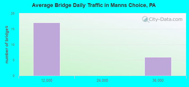
- 200,646Total average daily traffic
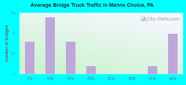
- 65,728Total average daily truck traffic
- National Bridge Inventory (NBI) Registered Bridges for Manns Choice
- No street view available for this location
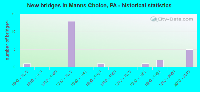
- New bridges - historical statistics
- 11900-1909
- 131930-1939
- 11950-1959
- 11980-1989
- 21990-1999
- 52010-2019
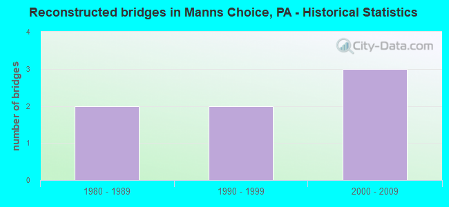
- Reconstructed bridges - Historical Statistics
- 21980-1989
- 21990-1999
- 32000-2009
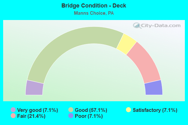
- Bridge Condition - Deck
- 7.1%Very good
- 57.1%Good
- 7.1%Satisfactory
- 21.4%Fair
- 7.1%Poor
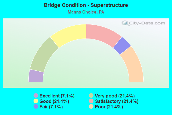
- Bridge Condition - Superstructure
- 7.1%Excellent
- 21.4%Very good
- 21.4%Good
- 21.4%Satisfactory
- 7.1%Fair
- 21.4%Poor
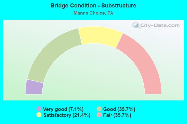
- Bridge Condition - Substructure
- 7.1%Very good
- 35.7%Good
- 21.4%Satisfactory
- 35.7%Fair
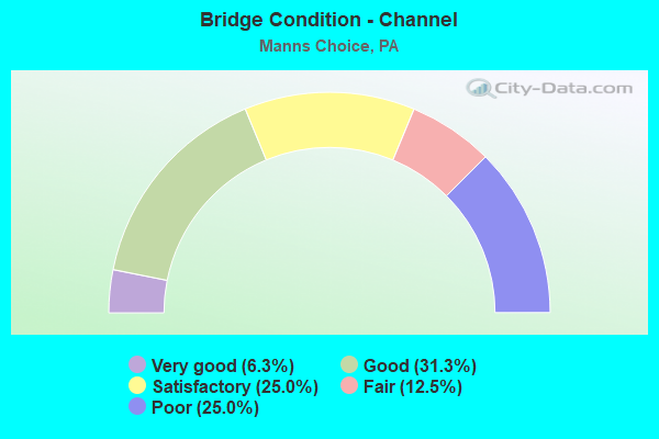
- Bridge Condition - Channel
- 6.3%Very good
- 31.3%Good
- 25.0%Satisfactory
- 12.5%Fair
- 25.0%Poor
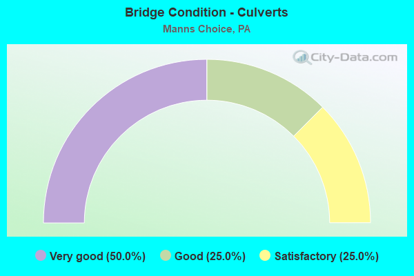
- Bridge Condition - Culverts
- 50.0%Very good
- 25.0%Good
- 25.0%Satisfactory
Find on map >> Show street view
Structure Number: 3996, Location: MANNS CHOICE (Lat: 40.002056, Lng: -78.597403), Route carried "on" structure: State highway 31, Year Built: 1933, Status: Open, Structure Length: 2.53m (8.30ft), Average Daily Traffic: 2,161 (year 2022), Truck Traffic: 5%, Average Future Daily Traffic: 4,354 (year 2032), Design Load: H 20, Features Intersected: BUFFALO RUN
Minimum Vertical Clearance: 30+ m (98+ ft), Kilometerpoint: 18.744, Lanes on structure: 2, Base Highway Network: Yes, Owner: State Highway Agency, Approaching Roadway Width: 9.8m (32.2ft), Material/Design: Concrete, Design/Construction: Tee Beam, Number Of Spans In Main Unit: 2, Length of Maximum Span: 12.2m (40.0ft), Curb or Sidewalk Widths: Left: 0.2m (0.7ft), Right: 0.2m (0.7ft), Curb-To-Curb Width: 9.8m (32.2ft), Out-to-Out Width: 10.6m (34.8ft)
Condition: Deck: Poor, Superstructure: Poor, Substructure: Fair, Channel: Poor, Operating Rating: 50.8 metric tons, Method Used To Determine Operating Rating: Load Factor (LF), Inventory Rating: 29.9 metric tons, Method Used To Determine Inventory Rating: Load Factor (LF), Structural Evaluation: Meets minimum limits, Deck Geometry: Meets minimum limits, Waterway Adequacy: Equal to present minimum criteria, Approach Roadway Alignment: Equal to present desirable criteria, Length Of Structure Improvement: 3.30m (10.83ft), Designated Inspection Frequency: Every 24 months, Inspection Date: October 2021, Deck Structure Type: Concrete Cast-file-Place, Wearing Surface/Protective System: Wearing Surface: Bituminous
Find on map >> Show street view
Structure Number: 3997, Location: 0.8 MI.N.OF MANNS CHOICE (Lat: 40.013233, Lng: -78.586153), Route carried "on" structure: State highway 31, Year Built: 1958, Year Reconstructed: 2007, Status: Open, Structure Length: 0.76m (2.49ft), Average Daily Traffic: 3,688 (year 2020), Truck Traffic: 18%, Average Future Daily Traffic: 5,653 (year 2032), Design Load: H 20, Features Intersected: COVE RUN
Minimum Vertical Clearance: 30+ m (98+ ft), Kilometerpoint: 19.911, Lanes on structure: 2, Base Highway Network: Yes, Owner: State Highway Agency, Approaching Roadway Width: 9.1m (29.9ft), Material/Design: Prestressed concrete, Design/Construction: Box Beam or Girders - Multiple, Number Of Spans In Main Unit: 1, Length of Maximum Span: 7.0m (23.0ft), Curb-To-Curb Width: 11.6m (38.1ft), Out-to-Out Width: 12.6m (41.3ft)
Condition: Deck: Good, Superstructure: Satisfactory, Substructure: Good, Channel: Satisfactory, Operating Rating: 72.6 metric tons, Method Used To Determine Operating Rating: Load Factor (LF), Inventory Rating: 43.5 metric tons, Method Used To Determine Inventory Rating: Load Factor (LF), Structural Evaluation: Equal to present minimum criteria, Deck Geometry: Somewhat better than minimum adequacy, Waterway Adequacy: Equal to present desirable criteria, Approach Roadway Alignment: Equal to present desirable criteria, Length Of Structure Improvement: 1.50m (4.92ft), Designated Inspection Frequency: Every 48 months, Inspection Date: December 2019, Deck Structure Type: Concrete Cast-file-Place, Wearing Surface/Protective System: Wearing Surface: Monolithic Concrete, Deck Protection: Epoxy Coated Reinforcing
Find on map >> Show street view
Structure Number: 3998, Location: 1.8 MI.NE.OF MANNS CHOICE (Lat: 40.020864, Lng: -78.576692), Route carried "on" structure: State highway 31, Year Built: 1933, Year Reconstructed: 2007, Status: Posted for load, Structure Length: 5.97m (19.59ft), Average Daily Traffic: 3,965 (year 2020), Truck Traffic: 14%, Average Future Daily Traffic: 5,842 (year 2032), Design Load: H 15, Features Intersected: RAYSTOWN BR JUNIATA RIV.
Minimum Vertical Clearance: 30+ m (98+ ft), Kilometerpoint: 20.664, Lanes on structure: 2, Base Highway Network: Yes, Owner: State Highway Agency, Approaching Roadway Width: 11.6m (38.1ft), Skew: 4 degrees, Material/Design: Concrete, Design/Construction: Tee Beam, Number Of Spans In Main Unit: 4, Length of Maximum Span: 14.3m (46.9ft), Curb or Sidewalk Widths: Left: 0.3m (1.0ft), Right: 0.3m (1.0ft), Curb-To-Curb Width: 11.7m (38.4ft), Out-to-Out Width: 12.6m (41.3ft)
Condition: Deck: Fair, Superstructure: Poor, Substructure: Fair, Channel: Poor, Operating Rating: 31.8 metric tons, Method Used To Determine Operating Rating: Load Factor (LF), Inventory Rating: 15.4 metric tons, Method Used To Determine Inventory Rating: Load Factor (LF), Structural Evaluation: Meets minimum limits, Deck Geometry: Somewhat better than minimum adequacy, Waterway Adequacy: Equal to present minimum criteria, Approach Roadway Alignment: Equal to present desirable criteria, Bridge Posting: Required (Relationship of Operating Rating to Maximum Legal Load: 20.0 - 29.9% below), Length Of Structure Improvement: 7.50m (24.61ft), Designated Inspection Frequency: Every 24 months, Underwater Inspection Frequency: Every 60 months, Other Special Inspection Frequency: Every 12 months, Inspection Date: March 2021, Underwater Inspection Date: April 2021, Bridge Improvement Cost: $181,000, Roadway Improvement Cost: $533,000, Total Project Cost: $2,444,000, Deck Structure Type: Concrete Cast-file-Place, Wearing Surface/Protective System: Wearing Surface: Bituminous, Membrane: Preformed Fabric
Find on map >> Show street view
Structure Number: 405, Location: 2.2 MI.S.OF MANNS CHOICE (Lat: 39.978247, Lng: -78.619139), Route carried "on" structure: State highway 96, Year Built: 1930, Status: Open, Structure Length: 0.76m (2.49ft), Average Daily Traffic: 1,679 (year 2020), Truck Traffic: 11%, Average Future Daily Traffic: 2,041 (year 2032), Design Load: H 15, Features Intersected: SULPHUR SPRINGS CREEK
Minimum Vertical Clearance: 30+ m (98+ ft), Kilometerpoint: 32.512, Lanes on structure: 2, Owner: State Highway Agency, Approaching Roadway Width: 8.5m (27.9ft), Material/Design: Concrete, Design/Construction: Tee Beam, Number Of Spans In Main Unit: 1, Length of Maximum Span: 7.3m (24.0ft), Curb or Sidewalk Widths: Left: 0.2m (0.7ft), Right: 0.2m (0.7ft), Curb-To-Curb Width: 9.2m (30.2ft), Out-to-Out Width: 10.0m (32.8ft)
Condition: Deck: Fair, Superstructure: Poor, Substructure: Fair, Channel: Poor, Operating Rating: 32.7 metric tons, Method Used To Determine Operating Rating: Load Factor (LF), Inventory Rating: 19.1 metric tons, Method Used To Determine Inventory Rating: Load Factor (LF), Structural Evaluation: Meets minimum limits, Deck Geometry: Somewhat better than minimum adequacy, Waterway Adequacy: Better than present minimum criteria, Approach Roadway Alignment: Equal to present desirable criteria, Length Of Structure Improvement: 0.91m (2.99ft), Designated Inspection Frequency: Every 24 months, Inspection Date: May 2020, Bridge Improvement Cost: $39,000, Roadway Improvement Cost: $225,000, Total Project Cost: $523,000, Deck Structure Type: Concrete Cast-file-Place, Wearing Surface/Protective System: Wearing Surface: Bituminous
Find on map >> Show street view
Structure Number: 4318, Location: 1.11 MILE EAST FROM PA 96 (Lat: 39.965797, Lng: -78.610033), Route carried "on" structure: Spur State highway , Year Built: 1984, Status: Open, Structure Length: 1.10m (3.61ft), Average Daily Traffic: 107 (year 2022), Truck Traffic: 8%, Average Future Daily Traffic: 171 (year 2032), Design Load: HS 20+Mod, Features Intersected: SULPHUR SPRINGS CREEK, Facility Carried by Structure: SR 3014
Minimum Vertical Clearance: 30+ m (98+ ft), Kilometerpoint: 1.804, Lanes on structure: 2, Owner: State Highway Agency, Approaching Roadway Width: 8.8m (28.9ft), Skew: 5 degrees, Material/Design: Concrete, Design/Construction: Culvert, Number Of Spans In Main Unit: 1, Length of Maximum Span: 6.1m (20.0ft), Curb-To-Curb Width: 8.5m (27.9ft), Out-to-Out Width: 9.6m (31.5ft)
Condition: Channel: Satisfactory, Culverts: Good, Operating Rating: 47.2 metric tons, Method Used To Determine Operating Rating: Load Factor (LF), Inventory Rating: 28.1 metric tons, Method Used To Determine Inventory Rating: Load Factor (LF), Structural Evaluation: Better than present minimum criteria, Deck Geometry: Equal to present minimum criteria, Waterway Adequacy: Equal to present desirable criteria, Approach Roadway Alignment: Equal to present desirable criteria, Length Of Structure Improvement: 1.70m (5.58ft), Designated Inspection Frequency: Every 24 months, Inspection Date: November 2021, Wearing Surface/Protective System: Wearing Surface: Bituminous
Find on map >> Show street view
Structure Number: 4325, Location: 1 MI.E.OF MANNS CHOICE (Lat: 39.998889, Lng: -78.578044), Route carried "on" structure: State highway , Year Built: 1937, Year Reconstructed: 2009, Status: Open, Structure Length: 1.07m (3.51ft), Average Daily Traffic: 118 (year 2020), Truck Traffic: 2%, Average Future Daily Traffic: 255 (year 2032), Design Load: HL 93, Features Intersected: COVE RUN, Facility Carried by Structure: SR 3017
Minimum Vertical Clearance: 30+ m (98+ ft), Kilometerpoint: 10.771, Lanes on structure: 2, Owner: State Highway Agency, Approaching Roadway Width: 5.5m (18.0ft), Skew: 4 degrees, Material/Design: Steel, Design/Construction: Stringer/Multi-beam, Number Of Spans In Main Unit: 1, Length of Maximum Span: 9.8m (32.2ft), Curb-To-Curb Width: 7.3m (24.0ft), Out-to-Out Width: 7.9m (25.9ft)
Condition: Deck: Good, Superstructure: Very good, Substructure: Satisfactory, Channel: Poor, Operating Rating: 78.0 metric tons, Method Used To Determine Operating Rating: Load and Resistance Factor (LRFR), Inventory Rating: 59.9 metric tons, Method Used To Determine Inventory Rating: Load and Resistance Factor (LRFR), Structural Evaluation: Equal to present minimum criteria, Deck Geometry: Somewhat better than minimum adequacy, Waterway Adequacy: Better than present minimum criteria, Approach Roadway Alignment: Better than present minimum criteria, Length Of Structure Improvement: 1.20m (3.94ft), Designated Inspection Frequency: Every 48 months, Inspection Date: Febuary 2020, Bridge Improvement Cost: $48,000, Roadway Improvement Cost: $264,000, Total Project Cost: $646,000, Deck Structure Type: Concrete Cast-file-Place, Wearing Surface/Protective System: Wearing Surface: Monolithic Concrete, Deck Protection: Galvanized Reinforcing
Find on map >> Show street view
Structure Number: 4326, Location: .5 MI.E.OF MANNS CHOICE (Lat: 40.002911, Lng: -78.580317), Route carried "on" structure: State highway , Year Built: 1937, Year Reconstructed: 1999, Status: Open, Structure Length: 0.88m (2.89ft), Average Daily Traffic: 84 (year 2020), Truck Traffic: 4%, Average Future Daily Traffic: 133 (year 2032), Design Load: H 20, Features Intersected: COVE RUN, Facility Carried by Structure: SR 3017
Minimum Vertical Clearance: 30+ m (98+ ft), Kilometerpoint: 11.275, Lanes on structure: 2, Owner: State Highway Agency, Approaching Roadway Width: 7.3m (24.0ft), Skew: 3 degrees, Material/Design: Steel, Design/Construction: Stringer/Multi-beam, Number Of Spans In Main Unit: 1, Length of Maximum Span: 8.5m (27.9ft), Curb-To-Curb Width: 7.3m (24.0ft), Out-to-Out Width: 7.8m (25.6ft)
Condition: Deck: Good, Superstructure: Good, Substructure: Fair, Channel: Good, Inventory Rating: 74.4 metric tons, Method Used To Determine Inventory Rating: Load Factor (LF), Structural Evaluation: Somewhat better than minimum adequacy, Deck Geometry: Equal to present minimum criteria, Waterway Adequacy: Better than present minimum criteria, Approach Roadway Alignment: Better than present minimum criteria, Length Of Structure Improvement: 1.60m (5.25ft), Designated Inspection Frequency: Every 24 months, Inspection Date: December 2021, Deck Structure Type: Concrete Cast-file-Place, Wearing Surface/Protective System: Wearing Surface: Monolithic Concrete, Deck Protection: Epoxy Coated Reinforcing
Find on map >> Show street view
Structure Number: 4338, Location: N. MANNS CHOICE(LOBSTOR) (Lat: 40.016744, Lng: -78.593275), Route carried "on" structure: State highway , Year Built: 1902, Year Reconstructed: 1996, Status: Posted for load, Structure Length: 4.27m (14.01ft), Average Daily Traffic: 168 (year 2021), Truck Traffic: 9%, Average Future Daily Traffic: 219 (year 2041), Design Load: H 10, Features Intersected: RAYSTOWN BR.JUNIATA RIV., Facility Carried by Structure: SR 4007 (C-101)
Minimum Vertical Clearance: 2.90m (9.51ft), Kilometerpoint: 0.692, Lanes on structure: 1, Owner: County Highway Agency, Approaching Roadway Width: 3.7m (12.1ft), Material/Design: Steel, Design/Construction: Stringer/Multi-beam, Number Of Spans In Main Unit: 1, Length of Maximum Span: 40.8m (133.9ft), Curb or Sidewalk Widths: Left: 0.2m (0.7ft), Right: 0.2m (0.7ft), Curb-To-Curb Width: 3.6m (11.8ft), Out-to-Out Width: 4.2m (13.8ft)
Condition: Deck: Good, Superstructure: Good, Substructure: Good, Channel: Satisfactory, Operating Rating: 48.1 metric tons, Method Used To Determine Operating Rating: Load Factor (LF), Inventory Rating: 19.1 metric tons, Method Used To Determine Inventory Rating: Load Factor (LF), Structural Evaluation: Somewhat better than minimum adequacy, Deck Geometry: High priority of replacement, Waterway Adequacy: Better than present minimum criteria, Approach Roadway Alignment: High priority of corrective action, Length Of Structure Improvement: 5.20m (17.06ft), Designated Inspection Frequency: Every 24 months, Other Special Inspection Frequency: Every 12 months, Inspection Date: June 2021, Other Special Inspection Date: June 2021, Deck Structure Type: Wood or Timber, Wearing Surface/Protective System: Wearing Surface: Wood or Timber
Find on map >> Show street view
Structure Number: 4414, Location: NEAR MANNS CHOICE (Lat: 40.016667, Lng: -78.606667), Route carried "on" structure: Interstate 76, Year Built: 1939, Year Reconstructed: 1989, Status: Open, Structure Length: 4.36m (14.30ft), Average Daily Traffic: 30,600 (year 2004), Truck Traffic: 35%, Average Future Daily Traffic: 34,792 (year 2030), Design Load: HS 20, Features Intersected: RAYSTN BR.TO JUNIATA RI.
Minimum Vertical Clearance: 30+ m (98+ ft), Kilometerpoint: 0.000, Lanes on structure: 4, Base Highway Network: Yes, Toll: On toll road, Owner: State Toll Authority, Approaching Roadway Width: 24.4m (80.1ft), Skew: 30 degrees, Material/Design: Steel continuous, Design/Construction: Stringer/Multi-beam, Number Of Spans In Main Unit: 2, Length of Maximum Span: 21.9m (71.9ft), Curb or Sidewalk Widths: Left: 0.2m (0.7ft), Right: 0.2m (0.7ft), Curb-To-Curb Width: 24.4m (80.1ft), Out-to-Out Width: 26.1m (85.6ft)
Condition: Deck: Satisfactory, Superstructure: Satisfactory, Substructure: Fair, Channel: Fair, Operating Rating: 86.2 metric tons, Method Used To Determine Operating Rating: Load Factor (LF), Inventory Rating: 51.7 metric tons, Method Used To Determine Inventory Rating: Load Factor (LF), Structural Evaluation: Somewhat better than minimum adequacy, Deck Geometry: Superior to present desirable criteria, Waterway Adequacy: Superior to present desirable criteria, Approach Roadway Alignment: Equal to present desirable criteria, Length Of Structure Improvement: 5.20m (17.06ft), Designated Inspection Frequency: Every 24 months, Inspection Date: September 2020, Bridge Improvement Cost: $323,000, Roadway Improvement Cost: $952,000, Total Project Cost: $4,364,000, Deck Structure Type: Concrete Cast-file-Place, Wearing Surface/Protective System: Wearing Surface: Latex Concrete, Deck Protection: Epoxy Coated Reinforcing
Find on map >> Show street view
Structure Number: 4417, Location: NEAR SR30 & SR31 (Lat: 40.025000, Lng: -78.573333), Route carried "on" structure: City street , Year Built: 1939, Status: Open, Structure Length: 2.65m (8.69ft), Average Daily Traffic: 200 (year 1992), Truck Traffic: 9%, Average Future Daily Traffic: 315 (year 2030), Design Load: HS 20, Features Intersected: PA TPK (I-76), Facility Carried by Structure: T-453; DIEHL RD.
Minimum Vertical Clearance: 30+ m (98+ ft), Kilometerpoint: 0.000, Lanes on structure: 2, Lanes under structure: 4, Owner: State Toll Authority, Approaching Roadway Width: 6.4m (21.0ft), Material/Design: Concrete, Design/Construction: Frame, Number Of Spans In Main Unit: 1, Length of Maximum Span: 23.8m (78.1ft), Curb or Sidewalk Widths: Left: 0.2m (0.7ft), Right: 0.2m (0.7ft), Curb-To-Curb Width: 6.1m (20.0ft), Out-to-Out Width: 7.1m (23.3ft)
Condition: Deck: Fair, Superstructure: Fair, Substructure: Satisfactory, Operating Rating: 47.2 metric tons, Method Used To Determine Operating Rating: Field evaluation and documented engineering judgment, Inventory Rating: 28.1 metric tons, Method Used To Determine Inventory Rating: Field evaluation and documented engineering judgment, Structural Evaluation: Somewhat better than minimum adequacy, Deck Geometry: Meets minimum limits, Underclear: High priority of corrective action, Approach Roadway Alignment: Better than present minimum criteria, Length Of Structure Improvement: 3.40m (11.15ft), Designated Inspection Frequency: Every 24 months, Inspection Date: September 2020, Bridge Improvement Cost: $15,000, Roadway Improvement Cost: $45,000, Total Project Cost: $206,000, Deck Structure Type: Concrete Cast-file-Place, Wearing Surface/Protective System: Wearing Surface: Monolithic Concrete
Find on map >> Show street view
Structure Number: 4419, Location: NEAR TR30 & TR31 JUNCTION (Lat: 40.038333, Lng: -78.558333), Route carried "on" structure: Interstate 76, Year Built: 1939, Year Reconstructed: 1988, Status: Open, Structure Length: 3.14m (10.30ft), Average Daily Traffic: 30,600 (year 2004), Truck Traffic: 35%, Average Future Daily Traffic: 34,792 (year 2030), Design Load: HS 20, Features Intersected: SR 0030; US 30 (LR 119)
Minimum Vertical Clearance: 30+ m (98+ ft), Kilometerpoint: 0.000, Lanes on structure: 4, Lanes under structure: 2, Base Highway Network: Yes, Toll: On toll road, Owner: State Toll Authority, Approaching Roadway Width: 24.4m (80.1ft), Skew: 35 degrees, Material/Design: Steel, Design/Construction: Girder and Floorbeam System, Number Of Spans In Main Unit: 1, Length of Maximum Span: 30.2m (99.1ft), Curb or Sidewalk Widths: Left: 0.2m (0.7ft), Right: 0.2m (0.7ft), Curb-To-Curb Width: 24.6m (80.7ft), Out-to-Out Width: 26.2m (86.0ft)
Condition: Deck: Good, Superstructure: Satisfactory, Substructure: Satisfactory, Inventory Rating: 66.2 metric tons, Method Used To Determine Inventory Rating: Load Factor (LF), Structural Evaluation: Equal to present minimum criteria, Deck Geometry: Superior to present desirable criteria, Underclear: Equal to present minimum criteria, Approach Roadway Alignment: Equal to present desirable criteria, Length Of Structure Improvement: 3.90m (12.80ft), Designated Inspection Frequency: Every 24 months, Critical Feature Inspection Frequency: Every 24 months, Inspection Date: September 2020, Critical Feature Inspection Date: September 2020, Deck Structure Type: Concrete Cast-file-Place, Wearing Surface/Protective System: Wearing Surface: Latex Concrete
Find on map >> Show street view
Structure Number: 442, Location: WEST OF BEDFORD INTERCHGE (Lat: 40.038333, Lng: -78.558333), Route carried "on" structure: Interstate 76, Year Built: 1939, Status: Open, Structure Length: 2.13m (6.99ft), Average Daily Traffic: 30,600 (year 2004), Truck Traffic: 35%, Average Future Daily Traffic: 34,792 (year 2030), Design Load: HS 20, Features Intersected: PA 56(LR 05047) & STREAM
Minimum Vertical Clearance: 30+ m (98+ ft), Kilometerpoint: 0.000, Lanes on structure: 4, Lanes under structure: 2, Base Highway Network: Yes, Toll: On toll road, Owner: State Toll Authority, Approaching Roadway Width: 23.2m (76.1ft), Skew: 31 degrees, Material/Design: Concrete, Design/Construction: Culvert, Number Of Spans In Main Unit: 1, Length of Maximum Span: 18.9m (62.0ft)
Condition: Channel: Fair, Culverts: Satisfactory, Inventory Rating: 76.2 metric tons, Method Used To Determine Inventory Rating: Load Factor (LF), Structural Evaluation: Equal to present minimum criteria, Underclear: High priority of corrective action, Waterway Adequacy: Superior to present desirable criteria, Approach Roadway Alignment: Equal to present desirable criteria, Length Of Structure Improvement: 2.80m (9.19ft), Designated Inspection Frequency: Every 24 months, Inspection Date: September 2020, Bridge Improvement Cost: $46,000, Roadway Improvement Cost: $134,000, Total Project Cost: $615,000
Find on map >> Show street view
Structure Number: 4494, Location: 2 MI.SW.OF MANNS CHOICE (Lat: 39.983300, Lng: -78.620825), Route carried "on" structure: City street , Year Built: 1995, Status: Open, Structure Length: 2.68m (8.79ft), Average Daily Traffic: 21 (year 2021), Average Future Daily Traffic: 29 (year 2041), Design Load: HS 25 or greater, Features Intersected: BUFFALO RUN, Facility Carried by Structure: T424,Sulfur Sprg R
Minimum Vertical Clearance: 30+ m (98+ ft), Kilometerpoint: 0.000, Lanes on structure: 2, Owner: County Highway Agency, Approaching Roadway Width: 7.3m (24.0ft), Material/Design: Prestressed concrete, Design/Construction: Box Beam or Girders - Multiple, Number Of Spans In Main Unit: 1, Length of Maximum Span: 26.2m (86.0ft), Curb or Sidewalk Widths: Left: 0.2m (0.7ft), Right: 0.2m (0.7ft), Curb-To-Curb Width: 7.6m (24.9ft), Out-to-Out Width: 8.7m (28.5ft)
Condition: Deck: Good, Superstructure: Good, Substructure: Good, Channel: Good, Inventory Rating: 35.4 metric tons, Method Used To Determine Inventory Rating: Load Factor (LF), Structural Evaluation: Better than present minimum criteria, Deck Geometry: Equal to present minimum criteria, Waterway Adequacy: Superior to present desirable criteria, Approach Roadway Alignment: Equal to present desirable criteria, Length Of Structure Improvement: 3.40m (11.15ft), Designated Inspection Frequency: Every 24 months, Inspection Date: March 2021, Deck Structure Type: Concrete Cast-file-Place, Wearing Surface/Protective System: Wearing Surface: Monolithic Concrete, Deck Protection: Epoxy Coated Reinforcing
Find on map >> Show street view
Structure Number: 4667, Location: .5 M.N.OF SULPHUR SPRINGS (Lat: 39.965819, Lng: -78.603903), Route carried "on" structure: State highway , Year Built: 2011, Status: Open, Structure Length: 0.88m (2.89ft), Average Daily Traffic: 118 (year 2020), Truck Traffic: 2%, Average Future Daily Traffic: 255 (year 2032), Design Load: HL 93, Features Intersected: TRIB BUFFALO RUN, Facility Carried by Structure: SR 3017
Minimum Vertical Clearance: 30+ m (98+ ft), Kilometerpoint: 5.919, Lanes on structure: 2, Owner: State Highway Agency, Approaching Roadway Width: 5.2m (17.1ft), Skew: 4 degrees, Material/Design: Concrete, Design/Construction: Culvert, Number Of Spans In Main Unit: 1, Length of Maximum Span: 6.7m (22.0ft), Curb-To-Curb Width: 7.3m (24.0ft), Out-to-Out Width: 15.1m (49.5ft)
Condition: Channel: Good, Culverts: Very good, Operating Rating: 55.1 metric tons, Method Used To Determine Operating Rating: Assigned ratings based on Load and Resistance Factor Design (LRFD) reported by rating factor (RF) using HL93 loadings, Inventory Rating: 34.7 metric tons, Method Used To Determine Inventory Rating: Assigned ratings based on Load and Resistance Factor Design (LRFD) reported by rating factor (RF) using HL93 loadings, Structural Evaluation: Equal to present desirable criteria, Deck Geometry: Somewhat better than minimum adequacy, Waterway Adequacy: Better than present minimum criteria, Approach Roadway Alignment: Equal to present desirable criteria, Designated Inspection Frequency: Every 24 months, Inspection Date: Febuary 2020, Wearing Surface/Protective System: Wearing Surface: Bituminous, Membrane: Preformed Fabric, Deck Protection: Epoxy Coated Reinforcing
Find on map >> Show street view
Structure Number: 47616, Location: 1.8 MI NW MANNS CHOICE (Lat: 40.016275, Lng: -78.617450), Route carried "on" structure: State highway 96, Year Built: 2012, Status: Open, Structure Length: 4.45m (14.60ft), Average Daily Traffic: 599 (year 2020), Truck Traffic: 6%, Average Future Daily Traffic: 781 (year 2032), Design Load: HL 93, Features Intersected: RAYSTOWN BR JUNIATA RIV
Minimum Vertical Clearance: 30+ m (98+ ft), Kilometerpoint: 35.962, Lanes on structure: 2, Owner: State Highway Agency, Approaching Roadway Width: 12.2m (40.0ft), Skew: 4 degrees, Material/Design: Prestressed concrete, Design/Construction: Box Beam or Girders - Single/Spread, Number Of Spans In Main Unit: 2, Length of Maximum Span: 21.6m (70.9ft), Curb or Sidewalk Widths: Left: 0.2m (0.7ft), Right: 0.2m (0.7ft), Curb-To-Curb Width: 12.2m (40.0ft), Out-to-Out Width: 13.2m (43.3ft)
Condition: Deck: Good, Superstructure: Very good, Substructure: Good, Channel: Satisfactory, Operating Rating: 51.5 metric tons, Method Used To Determine Operating Rating: Assigned ratings based on Load and Resistance Factor Design (LRFD) reported by rating factor (RF) using HL93 loadings, Inventory Rating: 32.4 metric tons, Method Used To Determine Inventory Rating: Assigned ratings based on Load and Resistance Factor Design (LRFD) reported by rating factor (RF) using HL93 loadings, Structural Evaluation: Better than present minimum criteria, Deck Geometry: Equal to present desirable criteria, Waterway Adequacy: Equal to present desirable criteria, Approach Roadway Alignment: Better than present minimum criteria, Designated Inspection Frequency: Every 48 months, Inspection Date: May 2020, Deck Structure Type: Concrete Cast-file-Place, Wearing Surface/Protective System: Wearing Surface: Epoxy Overlay, Deck Protection: Epoxy Coated Reinforcing
Find on map >> Show street view
Structure Number: 483, Location: N MLFRD TWP. 7 M S TR 848 (Lat: 41.831714, Lng: -75.709581), Route carried "on" structure: State highway , Year Built: 2013, Status: Open, Structure Length: 1.16m (3.81ft), Average Daily Traffic: 233 (year 2020), Truck Traffic: 8%, Average Future Daily Traffic: 354 (year 2034), Design Load: HL 93, Features Intersected: BR NINE PARTNERS CREEK, Facility Carried by Structure: SR 2063
Minimum Vertical Clearance: 30+ m (98+ ft), Kilometerpoint: 14.005, Lanes on structure: 2, Owner: State Highway Agency, Approaching Roadway Width: 7.0m (23.0ft), Skew: 1 degrees, Material/Design: Steel, Design/Construction: Stringer/Multi-beam, Number Of Spans In Main Unit: 1, Length of Maximum Span: 10.7m (35.1ft), Curb-To-Curb Width: 6.9m (22.6ft), Out-to-Out Width: 7.4m (24.3ft)
Condition: Deck: Very good, Superstructure: Excellent, Substructure: Very good, Channel: Good, Operating Rating: 51.5 metric tons, Method Used To Determine Operating Rating: Assigned ratings based on Load and Resistance Factor Design (LRFD) reported by rating factor (RF) using HL93 loadings, Inventory Rating: 39.5 metric tons, Method Used To Determine Inventory Rating: Assigned ratings based on Load and Resistance Factor Design (LRFD) reported by rating factor (RF) using HL93 loadings, Structural Evaluation: Equal to present desirable criteria, Deck Geometry: Meets minimum limits, Waterway Adequacy: Better than present minimum criteria, Approach Roadway Alignment: Equal to present desirable criteria, Designated Inspection Frequency: Every 24 months, Inspection Date: Febuary 2020, Deck Structure Type: Wood or Timber, Wearing Surface/Protective System: Wearing Surface: Bituminous, Membrane: Other, Deck Protection: Other
Find on map >> Show street view
Structure Number: 52772, Location: 2.7 MI S OF MANNS CHOICE (Lat: 39.972989, Lng: -78.624628), Route carried "on" structure: State highway 96, Year Built: 2015, Status: Open, Structure Length: 3.35m (10.99ft), Average Daily Traffic: 1,679 (year 2020), Truck Traffic: 11%, Average Future Daily Traffic: 2,008 (year 2034), Design Load: HL 93, Features Intersected: BUFFALO RUN
Minimum Vertical Clearance: 30+ m (98+ ft), Kilometerpoint: 31.746, Lanes on structure: 2, Owner: State Highway Agency, Approaching Roadway Width: 9.1m (29.9ft), Skew: 4 degrees, Material/Design: Prestressed concrete, Design/Construction: Stringer/Multi-beam, Number Of Spans In Main Unit: 1, Length of Maximum Span: 32.3m (106.0ft), Curb or Sidewalk Widths: Left: 0.2m (0.7ft), Right: 0.2m (0.7ft), Curb-To-Curb Width: 9.1m (29.9ft), Out-to-Out Width: 10.2m (33.5ft)
Condition: Deck: Good, Superstructure: Very good, Substructure: Good, Channel: Good, Operating Rating: 51.2 metric tons, Method Used To Determine Operating Rating: Assigned ratings based on Load and Resistance Factor Design (LRFD) reported by rating factor (RF) using HL93 loadings, Inventory Rating: 32.7 metric tons, Method Used To Determine Inventory Rating: Assigned ratings based on Load and Resistance Factor Design (LRFD) reported by rating factor (RF) using HL93 loadings, Structural Evaluation: Better than present minimum criteria, Deck Geometry: Somewhat better than minimum adequacy, Waterway Adequacy: Better than present minimum criteria, Approach Roadway Alignment: Equal to present desirable criteria, Length Of Structure Improvement: 3.35m (10.99ft), Designated Inspection Frequency: Every 24 months, Inspection Date: September 2021, Deck Structure Type: Concrete Cast-file-Place, Wearing Surface/Protective System: Wearing Surface: Monolithic Concrete, Deck Protection: Epoxy Coated Reinforcing
Find on map >> Show street view
Structure Number: 53602, Location: 4 MI S OF BEDFORD SPRINGS (Lat: 39.958936, Lng: -78.553144), Route carried "on" structure: State highway , Year Built: 2016, Status: Open, Structure Length: 0.61m (2.00ft), Average Daily Traffic: 148 (year 2020), Truck Traffic: 4%, Average Future Daily Traffic: 178 (year 2036), Design Load: HL 93, Features Intersected: TR SHOBERS RUN, Facility Carried by Structure: SR 3015
Minimum Vertical Clearance: 30+ m (98+ ft), Kilometerpoint: 5.477, Lanes on structure: 2, Owner: State Highway Agency, Approaching Roadway Width: 7.3m (24.0ft), Skew: 1 degrees, Material/Design: Aluminum, Iron, Design/Construction: Culvert, Number Of Spans In Main Unit: 1, Length of Maximum Span: 5.8m (19.0ft)
Condition: Channel: Very good, Culverts: Very good, Operating Rating: 39.0 metric tons, Method Used To Determine Operating Rating: Field evaluation and documented engineering judgment, Inventory Rating: 32.7 metric tons, Method Used To Determine Inventory Rating: Field evaluation and documented engineering judgment, Structural Evaluation: Equal to present desirable criteria, Waterway Adequacy: Better than present minimum criteria, Approach Roadway Alignment: Equal to present desirable criteria, Designated Inspection Frequency: Every 48 months, Inspection Date: March 2020
Find on map >> Show street view
Structure Number: 4412, Location: 2 MI NW OF MANNS CHOICE (Lat: 40.018681, Lng: -78.621444), Route carried "under" structure: Interstate 76, Year Built: 1995, Structure Length: 0. m, Average Daily Traffic: 27,137 (year 1997), Truck Traffic: 34%, Features Intersected: PA TURNPIKE (I-76);B-493, Facility Carried by Structure: PA 96 (LR 356)
Minimum Vertical Clearance: 4.72m (15.49ft), Kilometerpoint: 0.000, Lanes on structure: 2, Lanes under structure: 4, Material/Design: Steel, Design/Construction: Stringer/Multi-beam, Length of Maximum Span: 48.2m (158.1ft)
Find on map >> Show street view
Structure Number: 4415, Location: NEAR MANNS CHOICE (Lat: 40.017306, Lng: -78.593489), Route carried "under" structure: Interstate 76, Year Built: 1939, Structure Length: 0. m, Average Daily Traffic: 29,680 (year 2001), Truck Traffic: 38%, Features Intersected: PA TPK (I-76), Facility Carried by Structure: SR 4007 (LR 05097)
Minimum Vertical Clearance: 4.45m (14.60ft), Kilometerpoint: 0.000, Lanes on structure: 2, Lanes under structure: 4, Material/Design: Steel, Design/Construction: Girder and Floorbeam System, Length of Maximum Span: 29.6m (97.1ft)
Find on map >> Show street view
Structure Number: 4417, Location: NEAR SR30 & SR31 (Lat: 40.025000, Lng: -78.573333), Route carried "under" structure: Interstate 76, Year Built: 1939, Structure Length: 0. m, Average Daily Traffic: 30,600 (year 2004), Truck Traffic: 35%, Features Intersected: PA TPK (I-76), Facility Carried by Structure: T-453; DIEHL RD.
Minimum Vertical Clearance: 4.26m (13.98ft), Kilometerpoint: 0.000, Lanes on structure: 2, Lanes under structure: 4, Toll: On toll road, Material/Design: Concrete, Design/Construction: Frame, Length of Maximum Span: 23.8m (78.1ft)
Find on map >> Show street view
Structure Number: 4419, Location: NEAR TR30 & TR31 JUNCTION (Lat: 40.038333, Lng: -78.558333), Route carried "under" structure: US 30, Year Built: 1939, Structure Length: 0. m, Average Daily Traffic: 4,414 (year 2021), Truck Traffic: 10%, Features Intersected: SR 0030; US 30 (LR 119), Facility Carried by Structure: PA TPK (I-76)
Minimum Vertical Clearance: 4.47m (14.67ft), Kilometerpoint: 18.787, Lanes on structure: 4, Lanes under structure: 2, Material/Design: Steel, Design/Construction: Girder and Floorbeam System, Length of Maximum Span: 30.2m (99.1ft)
Find on map >> Show street view
Structure Number: 442, Location: WEST OF BEDFORD INTERCHGE (Lat: 40.038333, Lng: -78.558333), Route carried "under" structure: State highway 56, Year Built: 1939, Structure Length: 0. m, Average Daily Traffic: 2,047 (year 2022), Truck Traffic: 7%, Features Intersected: PA 56(LR 05047) & STREAM, Facility Carried by Structure: PA TPK (I-76)
Minimum Vertical Clearance: 6.38m (20.93ft), Kilometerpoint: 28.230, Lanes on structure: 4, Lanes under structure: 2, Material/Design: Concrete, Design/Construction: Culvert, Length of Maximum Span: 18.9m (62.0ft)