Bridge Statistics for Mansfield, Missouri (MO)
Condition, Traffic, Stress, Structural Evaluation, Project Costs
- National Bridge Inventory (NBI) Statistics
- 29Number of bridges
- 141ft / 42.6mTotal length
- $2,689,000Total costs
- 72,076Total average daily traffic
- 14,884Total average daily truck traffic
- National Bridge Inventory (NBI) Registered Bridges for Mansfield
- No street view available for this location
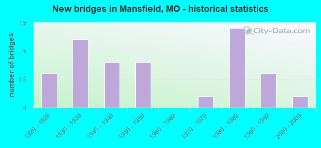
- New bridges - historical statistics
- 31920-1929
- 61930-1939
- 41940-1949
- 41950-1959
- 11970-1979
- 71980-1989
- 31990-1999
- 12000-2009

- Reconstructed bridges - Historical Statistics
- 11920-1929
- 01930-1939
- 11940-1949
- 01950-1959
- 11960-1969
- 21970-1979
- 11980-1989


- Bridge Condition - Deck
- 15.4%Very good
- 15.4%Good
- 38.5%Satisfactory
- 23.1%Fair
- 7.7%Poor

- Bridge Condition - Superstructure
- 15.4%Very good
- 15.4%Good
- 53.8%Satisfactory
- 7.7%Fair
- 7.7%Poor

- Bridge Condition - Substructure
- 23.1%Good
- 30.8%Satisfactory
- 30.8%Fair
- 15.4%Poor

- Bridge Condition - Channel
- 5.0%Very good
- 10.0%Good
- 50.0%Satisfactory
- 30.0%Fair
- 5.0%Poor

- Bridge Condition - Culverts
- 9.1%Good
- 54.5%Satisfactory
- 36.4%Fair
Find on map >> Show street view
Structure Number: 19779, Location: S 11 T 28 N R 15 W (Lat: 37.123169, Lng: -92.555058), Route carried "on" structure: County highway 233, Year Built: 1950, Status: Open, Structure Length: 0.76m (2.49ft), Average Daily Traffic: 80 (year 2021), Truck Traffic: 10%, Average Future Daily Traffic: 112 (year 2041), Features Intersected: BR OF WOLF CR, Facility Carried by Structure: OLD SPRINGFIELD RD
Minimum Vertical Clearance: 30+ m (98+ ft), Kilometerpoint: 1.931, Lanes on structure: 2, Owner: County Highway Agency, Approaching Roadway Width: 6.1m (20.0ft), Material/Design: Concrete, Design/Construction: Slab, Number Of Spans In Main Unit: 1, Length of Maximum Span: 7.3m (24.0ft), Curb-To-Curb Width: 5.5m (18.0ft), Out-to-Out Width: 5.5m (18.0ft)
Condition: Deck: Fair, Superstructure: Fair, Substructure: Poor, Channel: Poor, Operating Rating: 49.5 metric tons, Method Used To Determine Operating Rating: Allowable Stress (AS), Inventory Rating: 16.2 metric tons, Method Used To Determine Inventory Rating: Allowable Stress (AS), Structural Evaluation: Meets minimum limits, Deck Geometry: Meets minimum limits, Waterway Adequacy: Better than present minimum criteria, Approach Roadway Alignment: Meets minimum limits, Length Of Structure Improvement: 0.14m (0.46ft), Designated Inspection Frequency: Every 24 months, Inspection Date: December 2020, Bridge Improvement Cost: $102,000, Roadway Improvement Cost: $10,000, Total Project Cost: $153,000 ( Estimate for 2022), Deck Structure Type: Concrete Cast-file-Place, Wearing Surface/Protective System: Wearing Surface: Gravel
Find on map >> Show street view
Structure Number: 19968, Location: S 33 T 28 N R 15 W (Lat: 37.067458, Lng: -92.581428), Route carried "on" structure: County highway 242, Year Built: 1940, Year Reconstructed: 1987, Status: Open, Structure Length: 0.85m (2.79ft), Average Daily Traffic: 30 (year 2021), Truck Traffic: 10%, Average Future Daily Traffic: 42 (year 2041), Features Intersected: PRAIRIE HOLLOW CR, Facility Carried by Structure: PRAIRIE HOLLOW RD
Minimum Vertical Clearance: 30+ m (98+ ft), Kilometerpoint: 0.966, Lanes on structure: 1, Owner: County Highway Agency, Approaching Roadway Width: 6.7m (22.0ft), Material/Design: Concrete continuous, Design/Construction: Slab, Number Of Spans In Main Unit: 2, Length of Maximum Span: 3.4m (11.2ft), Curb-To-Curb Width: 4.6m (15.1ft), Out-to-Out Width: 4.6m (15.1ft)
Condition: Deck: Satisfactory, Superstructure: Satisfactory, Substructure: Fair, Channel: Fair, Operating Rating: 49.5 metric tons, Method Used To Determine Operating Rating: Allowable Stress (AS), Inventory Rating: 16.2 metric tons, Method Used To Determine Inventory Rating: Allowable Stress (AS), Structural Evaluation: Somewhat better than minimum adequacy, Deck Geometry: Better than present minimum criteria, Waterway Adequacy: Equal to present minimum criteria, Approach Roadway Alignment: Equal to present minimum criteria, Designated Inspection Frequency: Every 24 months, Inspection Date: December 2020, Deck Structure Type: Concrete Cast-file-Place, Wearing Surface/Protective System: Wearing Surface: Monolithic Concrete
Find on map >> Show street view
Structure Number: 19971, Location: S 33 T 28 N R 15 W (Lat: 37.066217, Lng: -92.580128), Route carried "on" structure: County highway 242, Year Built: 1940, Year Reconstructed: 1965, Status: Open, Structure Length: 0.88m (2.89ft), Average Daily Traffic: 30 (year 2021), Truck Traffic: 10%, Average Future Daily Traffic: 42 (year 2041), Features Intersected: PRAIRIE HOLLOW CR, Facility Carried by Structure: PRAIRIE HOLLOW RD
Minimum Vertical Clearance: 30+ m (98+ ft), Kilometerpoint: 1.127, Lanes on structure: 2, Owner: County Highway Agency, Approaching Roadway Width: 6.7m (22.0ft), Material/Design: Concrete continuous, Design/Construction: Slab, Number Of Spans In Main Unit: 2, Length of Maximum Span: 4.6m (15.1ft), Curb-To-Curb Width: 6.5m (21.3ft), Out-to-Out Width: 6.5m (21.3ft)
Condition: Deck: Satisfactory, Superstructure: Satisfactory, Substructure: Fair, Channel: Fair, Operating Rating: 49.5 metric tons, Method Used To Determine Operating Rating: Allowable Stress (AS), Inventory Rating: 16.2 metric tons, Method Used To Determine Inventory Rating: Allowable Stress (AS), Structural Evaluation: Somewhat better than minimum adequacy, Deck Geometry: Somewhat better than minimum adequacy, Waterway Adequacy: Equal to present minimum criteria, Approach Roadway Alignment: Equal to present minimum criteria, Designated Inspection Frequency: Every 24 months, Inspection Date: December 2020, Deck Structure Type: Concrete Cast-file-Place, Wearing Surface/Protective System: Wearing Surface: Gravel
Find on map >> Show street view
Structure Number: 20001, Location: S 29 T 28 N R 15 W (Lat: 37.092481, Lng: -92.597622), Route carried "on" structure: County highway 243, Year Built: 1994, Status: Open, Structure Length: 0.67m (2.20ft), Average Daily Traffic: 50 (year 2021), Truck Traffic: 10%, Average Future Daily Traffic: 70 (year 2041), Features Intersected: PRAIRIE HOLLOW CR, Facility Carried by Structure: ROCK RD
Minimum Vertical Clearance: 30+ m (98+ ft), Kilometerpoint: 1.770, Lanes on structure: 2, Owner: County Highway Agency, Approaching Roadway Width: 5.8m (19.0ft), Skew: 1 degrees, Material/Design: Concrete continuous, Design/Construction: Slab, Number Of Spans In Main Unit: 2, Length of Maximum Span: 3.4m (11.2ft), Curb-To-Curb Width: 6.8m (22.3ft), Out-to-Out Width: 6.8m (22.3ft)
Condition: Deck: Very good, Superstructure: Very good, Substructure: Good, Channel: Very good, Operating Rating: 45.9 metric tons, Method Used To Determine Operating Rating: Load Factor (LF), Inventory Rating: 27.0 metric tons, Method Used To Determine Inventory Rating: Load Factor (LF), Structural Evaluation: Equal to present minimum criteria, Deck Geometry: Somewhat better than minimum adequacy, Waterway Adequacy: Better than present minimum criteria, Approach Roadway Alignment: Equal to present minimum criteria, Designated Inspection Frequency: Every 24 months, Inspection Date: December 2020, Deck Structure Type: Concrete Cast-file-Place, Wearing Surface/Protective System: Wearing Surface: Monolithic Concrete
Find on map >> Show street view
Structure Number: 22828, Location: S 14 T 28 N R 16 W (Lat: 37.117814, Lng: -92.648592), Route carried "on" structure: County highway 376, Year Built: 1936, Status: Open, Structure Length: 1.22m (4.00ft), Average Daily Traffic: 40 (year 2021), Truck Traffic: 10%, Average Future Daily Traffic: 56 (year 2041), Features Intersected: BAKER CR, Facility Carried by Structure: LUCKY RD
Minimum Vertical Clearance: 30+ m (98+ ft), Kilometerpoint: 2.736, Lanes on structure: 2, Owner: County Highway Agency, Approaching Roadway Width: 11.6m (38.1ft), Material/Design: Concrete continuous, Design/Construction: Culvert, Number Of Spans In Main Unit: 3, Length of Maximum Span: 4.0m (13.1ft), Curb-To-Curb Width: 14.3m (46.9ft), Out-to-Out Width: 14.9m (48.9ft)
Condition: Channel: Satisfactory, Culverts: Satisfactory, Operating Rating: 49.5 metric tons, Method Used To Determine Operating Rating: Allowable Stress (AS), Inventory Rating: 16.2 metric tons, Method Used To Determine Inventory Rating: Allowable Stress (AS), Structural Evaluation: Somewhat better than minimum adequacy, Deck Geometry: Superior to present desirable criteria, Waterway Adequacy: Equal to present desirable criteria, Approach Roadway Alignment: Equal to present desirable criteria, Designated Inspection Frequency: Every 24 months, Inspection Date: December 2020, Deck Structure Type: Concrete Cast-file-Place, Wearing Surface/Protective System: Wearing Surface: Monolithic Concrete
Find on map >> Show street view
Structure Number: 22846, Location: S 28 T 28 N R 15 W (Lat: 37.081389, Lng: -92.590344), Route carried "on" structure: County highway 377, Year Built: 1925, Status: Open, Structure Length: 1.65m (5.41ft), Average Daily Traffic: 45 (year 2021), Truck Traffic: 10%, Average Future Daily Traffic: 63 (year 2041), Features Intersected: PARIRIE HOLLOW CR, Facility Carried by Structure: OLD HWY 5
Minimum Vertical Clearance: 30+ m (98+ ft), Kilometerpoint: 2.897, Lanes on structure: 2, Owner: County Highway Agency, Approaching Roadway Width: 8.5m (27.9ft), Material/Design: Concrete, Design/Construction: Stringer/Multi-beam, Number Of Spans In Main Unit: 1, Length of Maximum Span: 15.8m (51.8ft), Curb-To-Curb Width: 6.1m (20.0ft), Out-to-Out Width: 7.0m (23.0ft)
Condition: Deck: Good, Superstructure: Good, Substructure: Satisfactory, Channel: Satisfactory, Operating Rating: 49.5 metric tons, Method Used To Determine Operating Rating: Allowable Stress (AS), Inventory Rating: 16.2 metric tons, Method Used To Determine Inventory Rating: Allowable Stress (AS), Structural Evaluation: Somewhat better than minimum adequacy, Deck Geometry: Somewhat better than minimum adequacy, Waterway Adequacy: Better than present minimum criteria, Approach Roadway Alignment: Equal to present minimum criteria, Designated Inspection Frequency: Every 24 months, Inspection Date: December 2020, Deck Structure Type: Concrete Cast-file-Place, Wearing Surface/Protective System: Wearing Surface: Bituminous
Find on map >> Show street view
Structure Number: 22849, Location: S 33 T 28 N R 15 W (Lat: 37.072578, Lng: -92.588139), Route carried "on" structure: County highway 377, Year Built: 1925, Status: Open, Structure Length: 0.85m (2.79ft), Average Daily Traffic: 45 (year 2021), Truck Traffic: 10%, Average Future Daily Traffic: 63 (year 2041), Design Load: H 15, Features Intersected: CREEK, Facility Carried by Structure: OLD HWY 5
Minimum Vertical Clearance: 30+ m (98+ ft), Kilometerpoint: 4.184, Lanes on structure: 2, Owner: County Highway Agency, Approaching Roadway Width: 8.5m (27.9ft), Material/Design: Concrete continuous, Design/Construction: Culvert, Number Of Spans In Main Unit: 2, Length of Maximum Span: 4.0m (13.1ft), Curb-To-Curb Width: 10.4m (34.1ft), Out-to-Out Width: 11.0m (36.1ft)
Condition: Channel: Fair, Culverts: Satisfactory, Operating Rating: 49.5 metric tons, Method Used To Determine Operating Rating: Allowable Stress (AS), Inventory Rating: 16.2 metric tons, Method Used To Determine Inventory Rating: Allowable Stress (AS), Structural Evaluation: Somewhat better than minimum adequacy, Deck Geometry: Superior to present desirable criteria, Waterway Adequacy: Better than present minimum criteria, Approach Roadway Alignment: Equal to present desirable criteria, Designated Inspection Frequency: Every 24 months, Inspection Date: December 2020, Deck Structure Type: Concrete Cast-file-Place, Wearing Surface/Protective System: Wearing Surface: Bituminous
Find on map >> Show street view
Structure Number: 26, Location: S 17 T 28 N R 16 W (Lat: 37.117150, Lng: -92.610450), Route carried "on" structure: US 60, Year Built: 1957, Year Reconstructed: 1984, Status: Open, Structure Length: 0.99m (3.25ft), Average Daily Traffic: 13,320 (year 2021), Truck Traffic: 23%, Average Future Daily Traffic: 23,310 (year 2041), Design Load: H 20, Features Intersected: WOLF CR
Minimum Vertical Clearance: 30+ m (98+ ft), Kilometerpoint: 201.833, Lanes on structure: 6, Base Highway Network: Yes, Owner: State Highway Agency, Approaching Roadway Width: 30.5m (100.1ft), Skew: 4 degrees, Material/Design: Concrete continuous, Design/Construction: Culvert, Number Of Spans In Main Unit: 2, Length of Maximum Span: 3.7m (12.1ft)
Condition: Channel: Satisfactory, Culverts: Satisfactory, Operating Rating: 57.6 metric tons, Method Used To Determine Operating Rating: Load Factor (LF), Inventory Rating: 34.2 metric tons, Method Used To Determine Inventory Rating: Load Factor (LF), Structural Evaluation: Equal to present minimum criteria, Waterway Adequacy: Equal to present desirable criteria, Approach Roadway Alignment: Equal to present desirable criteria, Designated Inspection Frequency: Every 24 months, Inspection Date: Febuary 2022
Find on map >> Show street view
Structure Number: 281, Location: S 20 T 28 N R 15 W (Lat: 37.107981, Lng: -92.601247), Route carried "on" structure: State highway 5, Year Built: 1958, Status: Open, Structure Length: 1.93m (6.33ft), Average Daily Traffic: 5,158 (year 2021), Truck Traffic: 21%, Average Future Daily Traffic: 8,769 (year 2041), Design Load: H 20, Features Intersected: BNSF RR
Minimum Vertical Clearance: 30+ m (98+ ft), Kilometerpoint: 481.478, Lanes on structure: 2, Base Highway Network: Yes, Owner: State Highway Agency, Approaching Roadway Width: 11.6m (38.1ft), Material/Design: Steel, Design/Construction: Stringer/Multi-beam, Number Of Spans In Main Unit: 1, Length of Maximum Span: 19.3m (63.3ft), Curb-To-Curb Width: 8.5m (27.9ft), Out-to-Out Width: 9.9m (32.5ft)
Condition: Deck: Fair, Superstructure: Satisfactory, Substructure: Fair, Operating Rating: 37.8 metric tons, Method Used To Determine Operating Rating: Load Factor (LF), Inventory Rating: 22.5 metric tons, Method Used To Determine Inventory Rating: Load Factor (LF), Structural Evaluation: Somewhat better than minimum adequacy, Deck Geometry: High priority of replacement, Underclear: Somewhat better than minimum adequacy, Approach Roadway Alignment: Equal to present desirable criteria, Length Of Structure Improvement: 0.27m (0.89ft), Designated Inspection Frequency: Every 24 months, Inspection Date: Febuary 2022, Bridge Improvement Cost: $342,000, Roadway Improvement Cost: $34,000, Total Project Cost: $513,000 ( Estimate for 2022), Deck Structure Type: Concrete Cast-file-Place, Wearing Surface/Protective System: Wearing Surface: Bituminous
Find on map >> Show street view
Structure Number: 28157, Location: S 33 T 28 N R 15 W (Lat: 37.070733, Lng: -92.583697), Route carried "on" structure: County highway 242, Year Built: 1996, Status: Open, Structure Length: 1.46m (4.79ft), Average Daily Traffic: 30 (year 2021), Truck Traffic: 10%, Average Future Daily Traffic: 42 (year 2041), Design Load: HS 20, Features Intersected: PRAIRIE HOLLOW CR, Facility Carried by Structure: PRAIRIE HOLLOW RD
Minimum Vertical Clearance: 30+ m (98+ ft), Kilometerpoint: 0.644, Lanes on structure: 2, Owner: County Highway Agency, Approaching Roadway Width: 5.5m (18.0ft), Skew: 4 degrees, Material/Design: Concrete continuous, Design/Construction: Slab, Number Of Spans In Main Unit: 3, Length of Maximum Span: 4.3m (14.1ft), Curb-To-Curb Width: 6.1m (20.0ft), Out-to-Out Width: 6.1m (20.0ft)
Condition: Deck: Good, Superstructure: Good, Substructure: Good, Channel: Satisfactory, Operating Rating: 32.4 metric tons, Method Used To Determine Operating Rating: Load Factor (LF), Inventory Rating: 19.8 metric tons, Method Used To Determine Inventory Rating: Load Factor (LF), Structural Evaluation: Somewhat better than minimum adequacy, Deck Geometry: Somewhat better than minimum adequacy, Waterway Adequacy: Equal to present minimum criteria, Approach Roadway Alignment: Equal to present desirable criteria, Designated Inspection Frequency: Every 24 months, Inspection Date: December 2020, Deck Structure Type: Concrete Cast-file-Place
Find on map >> Show street view
Structure Number: 28425, Location: S 31 T 29 N R 15 W (Lat: 37.165261, Lng: -92.613861), Route carried "on" structure: County highway 281, Year Built: 1999, Status: Open, Structure Length: 1.34m (4.40ft), Average Daily Traffic: 75 (year 2021), Truck Traffic: 10%, Average Future Daily Traffic: 105 (year 2041), Design Load: HS 20, Features Intersected: BAKER CR, Facility Carried by Structure: BAKER CREEK RD
Minimum Vertical Clearance: 30+ m (98+ ft), Kilometerpoint: 4.667, Lanes on structure: 2, Owner: County Highway Agency, Approaching Roadway Width: 5.5m (18.0ft), Skew: 4 degrees, Material/Design: Concrete continuous, Design/Construction: Culvert, Number Of Spans In Main Unit: 2, Length of Maximum Span: 6.1m (20.0ft), Curb-To-Curb Width: 6.2m (20.3ft), Out-to-Out Width: 6.2m (20.3ft)
Condition: Channel: Satisfactory, Culverts: Good, Operating Rating: 54.0 metric tons, Method Used To Determine Operating Rating: Load Factor (LF), Inventory Rating: 32.4 metric tons, Method Used To Determine Inventory Rating: Load Factor (LF), Structural Evaluation: Better than present minimum criteria, Deck Geometry: Somewhat better than minimum adequacy, Waterway Adequacy: Better than present minimum criteria, Approach Roadway Alignment: Equal to present minimum criteria, Designated Inspection Frequency: Every 24 months, Inspection Date: December 2020, Deck Structure Type: Concrete Cast-file-Place
Find on map >> Show street view
Structure Number: 28554, Location: S 3 T 27 N R 15 W (Lat: 37.053569, Lng: -92.569789), Route carried "on" structure: County highway 35, Year Built: 1940, Year Reconstructed: 1978, Status: Posted for load, Structure Length: 0.79m (2.59ft), Average Daily Traffic: 30 (year 2020), Truck Traffic: 10%, Average Future Daily Traffic: 44 (year 2040), Features Intersected: PRAIRIE CR, Facility Carried by Structure: COUNTY RD 109
Minimum Vertical Clearance: 30+ m (98+ ft), Kilometerpoint: 0.161, Lanes on structure: 1, Owner: County Highway Agency, Approaching Roadway Width: 4.3m (14.1ft), Skew: 1 degrees, Material/Design: Concrete continuous, Design/Construction: Slab, Number Of Spans In Main Unit: 2, Length of Maximum Span: 3.8m (12.5ft), Curb-To-Curb Width: 4.3m (14.1ft), Out-to-Out Width: 4.3m (14.1ft)
Condition: Deck: Satisfactory, Superstructure: Satisfactory, Substructure: Fair, Channel: Fair, Operating Rating: 10.8 metric tons, Method Used To Determine Operating Rating: Load Factor (LF), Inventory Rating: 6.3 metric tons, Method Used To Determine Inventory Rating: Load Factor (LF), Structural Evaluation: High priority of replacement, Deck Geometry: Equal to present minimum criteria, Waterway Adequacy: Better than present minimum criteria, Approach Roadway Alignment: Equal to present minimum criteria, Bridge Posting: Required (Relationship of Operating Rating to Maximum Legal Load: 0.1 - 9.9% below), Length Of Structure Improvement: 0.14m (0.46ft), Designated Inspection Frequency: Every 24 months, Inspection Date: March 2022, Bridge Improvement Cost: $102,000, Roadway Improvement Cost: $10,000, Total Project Cost: $153,000 ( Estimate for 2022), Deck Structure Type: Concrete Cast-file-Place
Find on map >> Show street view
Structure Number: 29162, Location: S 12 T 28 N R 15 W (Lat: 37.132608, Lng: -92.537189), Route carried "on" structure: County highway 231, Year Built: 2001, Status: Open, Structure Length: 1.01m (3.31ft), Average Daily Traffic: 50 (year 2021), Truck Traffic: 10%, Average Future Daily Traffic: 70 (year 2041), Features Intersected: SPENCE CR, Facility Carried by Structure: SPENCE CREEK RD
Minimum Vertical Clearance: 30+ m (98+ ft), Kilometerpoint: 0.225, Lanes on structure: 2, Owner: County Highway Agency, Approaching Roadway Width: 5.5m (18.0ft), Material/Design: Concrete continuous, Design/Construction: Slab, Number Of Spans In Main Unit: 2, Length of Maximum Span: 4.7m (15.4ft), Curb-To-Curb Width: 6.7m (22.0ft), Out-to-Out Width: 6.7m (22.0ft)
Condition: Deck: Very good, Superstructure: Very good, Substructure: Good, Channel: Satisfactory, Operating Rating: 55.8 metric tons, Method Used To Determine Operating Rating: Load Factor (LF), Inventory Rating: 33.3 metric tons, Method Used To Determine Inventory Rating: Load Factor (LF), Structural Evaluation: Better than present minimum criteria, Deck Geometry: Somewhat better than minimum adequacy, Waterway Adequacy: Better than present minimum criteria, Approach Roadway Alignment: Equal to present minimum criteria, Designated Inspection Frequency: Every 24 months, Inspection Date: December 2020, Deck Structure Type: Concrete Cast-file-Place, Wearing Surface/Protective System: Wearing Surface: Monolithic Concrete
Find on map >> Show street view
Structure Number: 3012, Location: S 18 T 28 N R 14 W (Lat: 37.108997, Lng: -92.512528), Route carried "on" structure: US 60, Year Built: 1977, Status: Open, Structure Length: 0.63m (2.07ft), Average Daily Traffic: 12,509 (year 2021), Truck Traffic: 23%, Average Future Daily Traffic: 21,891 (year 2041), Design Load: HS 20, Features Intersected: SPENCE CR
Minimum Vertical Clearance: 30+ m (98+ ft), Kilometerpoint: 210.707, Lanes on structure: 4, Base Highway Network: Yes, Owner: State Highway Agency, Approaching Roadway Width: 39.0m (128.0ft), Skew: 20 degrees, Material/Design: Concrete continuous, Design/Construction: Culvert, Number Of Spans In Main Unit: 2, Length of Maximum Span: 3.0m (9.8ft)
Condition: Channel: Good, Culverts: Satisfactory, Operating Rating: 87.3 metric tons, Method Used To Determine Operating Rating: Field evaluation and documented engineering judgment, Inventory Rating: 52.2 metric tons, Method Used To Determine Inventory Rating: Field evaluation and documented engineering judgment, Structural Evaluation: Equal to present minimum criteria, Waterway Adequacy: Equal to present desirable criteria, Approach Roadway Alignment: Equal to present desirable criteria, Designated Inspection Frequency: Every 24 months, Inspection Date: Febuary 2022
Find on map >> Show street view
Structure Number: 3182, Location: S 17 T 28 N R 15 W (Lat: 37.117192, Lng: -92.599017), Route carried "on" structure: State highway 5, Year Built: 1984, Status: Open, Structure Length: 7.38m (24.21ft), Average Daily Traffic: 2,045 (year 2021), Truck Traffic: 11%, Average Future Daily Traffic: 3,477 (year 2041), Design Load: H 20, Features Intersected: US 60
Minimum Vertical Clearance: 30+ m (98+ ft), Kilometerpoint: 480.403, Lanes on structure: 2, Lanes under structure: 4, Base Highway Network: Yes, Owner: State Highway Agency, Approaching Roadway Width: 13.4m (44.0ft), Material/Design: Steel continuous, Design/Construction: Stringer/Multi-beam, Number Of Spans In Main Unit: 2, Length of Maximum Span: 34.1m (111.9ft), Curb or Sidewalk Widths: Left: 0.2m (0.7ft), Right: 0.2m (0.7ft), Curb-To-Curb Width: 13.4m (44.0ft), Out-to-Out Width: 14.2m (46.6ft)
Condition: Deck: Satisfactory, Superstructure: Satisfactory, Substructure: Satisfactory, Operating Rating: 43.2 metric tons, Method Used To Determine Operating Rating: Load Factor (LF), Inventory Rating: 26.1 metric tons, Method Used To Determine Inventory Rating: Load Factor (LF), Structural Evaluation: Equal to present minimum criteria, Deck Geometry: Better than present minimum criteria, Underclear: Better than present minimum criteria, Approach Roadway Alignment: Equal to present desirable criteria, Designated Inspection Frequency: Every 24 months, Inspection Date: Febuary 2022, Deck Structure Type: Concrete Cast-file-Place, Wearing Surface/Protective System: Wearing Surface: Bituminous, Deck Protection: Epoxy Coated Reinforcing
Find on map >> Show street view
Structure Number: 3183, Location: S 16 T 28 N R 15 W (Lat: 37.115736, Lng: -92.576308), Route carried "on" structure: State highway 5, Year Built: 1985, Status: Open, Structure Length: 6.83m (22.41ft), Average Daily Traffic: 3,034 (year 2021), Truck Traffic: 11%, Average Future Daily Traffic: 5,158 (year 2041), Design Load: H 20, Features Intersected: US 60
Minimum Vertical Clearance: 30+ m (98+ ft), Kilometerpoint: 89.277, Lanes on structure: 2, Lanes under structure: 4, Base Highway Network: Yes, Owner: State Highway Agency, Approaching Roadway Width: 13.4m (44.0ft), Material/Design: Steel continuous, Design/Construction: Stringer/Multi-beam, Number Of Spans In Main Unit: 2, Length of Maximum Span: 35.4m (116.1ft), Curb or Sidewalk Widths: Left: 0.2m (0.7ft), Right: 0.2m (0.7ft), Curb-To-Curb Width: 13.4m (44.0ft), Out-to-Out Width: 14.2m (46.6ft)
Condition: Deck: Fair, Superstructure: Satisfactory, Substructure: Satisfactory, Operating Rating: 45.0 metric tons, Method Used To Determine Operating Rating: Allowable Stress (AS), Inventory Rating: 27.9 metric tons, Method Used To Determine Inventory Rating: Allowable Stress (AS), Structural Evaluation: Equal to present minimum criteria, Deck Geometry: Better than present minimum criteria, Underclear: Better than present minimum criteria, Approach Roadway Alignment: Equal to present minimum criteria, Designated Inspection Frequency: Every 24 months, Inspection Date: Febuary 2022, Deck Structure Type: Concrete Cast-file-Place, Wearing Surface/Protective System: Wearing Surface: Bituminous, Deck Protection: Epoxy Coated Reinforcing
Find on map >> Show street view
Structure Number: 3233, Location: S 17 T 28 N R 15 W (Lat: 37.121736, Lng: -92.597761), Route carried "on" structure: State highway EE, Year Built: 1984, Status: Open, Structure Length: 1.12m (3.67ft), Average Daily Traffic: 600 (year 2021), Truck Traffic: 3%, Average Future Daily Traffic: 930 (year 2041), Design Load: H 15, Features Intersected: WOLF CR
Minimum Vertical Clearance: 30+ m (98+ ft), Kilometerpoint: 5.039, Lanes on structure: 2, Owner: State Highway Agency, Approaching Roadway Width: 6.1m (20.0ft), Skew: 13 degrees, Material/Design: Concrete continuous, Design/Construction: Culvert, Number Of Spans In Main Unit: 3, Length of Maximum Span: 3.0m (9.8ft)
Condition: Channel: Satisfactory, Culverts: Satisfactory, Operating Rating: 54.0 metric tons, Method Used To Determine Operating Rating: Field evaluation and documented engineering judgment, Inventory Rating: 32.4 metric tons, Method Used To Determine Inventory Rating: Field evaluation and documented engineering judgment, Structural Evaluation: Equal to present minimum criteria, Waterway Adequacy: Superior to present desirable criteria, Approach Roadway Alignment: Equal to present minimum criteria, Designated Inspection Frequency: Every 24 months, Inspection Date: Febuary 2022
Find on map >> Show street view
Structure Number: 4749, Location: S 17 T 28 N R 15 W (Lat: 37.116750, Lng: -92.609700), Route carried "on" structure: State highway B, Year Built: 1924, Year Reconstructed: 1933, Status: Open, Structure Length: 1.19m (3.90ft), Average Daily Traffic: 514 (year 2021), Truck Traffic: 6%, Average Future Daily Traffic: 797 (year 2041), Design Load: H 15, Features Intersected: WOLF CR
Minimum Vertical Clearance: 30+ m (98+ ft), Kilometerpoint: 0.925, Lanes on structure: 2, Owner: State Highway Agency, Approaching Roadway Width: 11.0m (36.1ft), Skew: 3 degrees, Material/Design: Concrete continuous, Design/Construction: Culvert, Number Of Spans In Main Unit: 3, Length of Maximum Span: 3.0m (9.8ft)
Condition: Channel: Satisfactory, Culverts: Fair, Operating Rating: 45.0 metric tons, Method Used To Determine Operating Rating: Load Factor (LF), Inventory Rating: 27.0 metric tons, Method Used To Determine Inventory Rating: Load Factor (LF), Structural Evaluation: Somewhat better than minimum adequacy, Waterway Adequacy: Equal to present desirable criteria, Approach Roadway Alignment: Equal to present desirable criteria, Designated Inspection Frequency: Every 24 months, Inspection Date: Febuary 2022
Find on map >> Show street view
Structure Number: 4939, Location: S 21 T 28 N R 15 W (Lat: 37.100328, Lng: -92.576094), Route carried "on" structure: State highway U, Year Built: 1930, Status: Posted for load, Structure Length: 5.27m (17.29ft), Average Daily Traffic: 2,052 (year 2021), Truck Traffic: 7%, Average Future Daily Traffic: 3,181 (year 2041), Design Load: H 15, Features Intersected: CST SOUTH ST, BNSF RR
Minimum Vertical Clearance: 30+ m (98+ ft), Kilometerpoint: 0.108, Lanes on structure: 1, Lanes under structure: 2, Owner: State Highway Agency, Approaching Roadway Width: 6.1m (20.0ft), Skew: 2 degrees, Material/Design: Concrete, Design/Construction: Tee Beam, Number Of Spans In Main Unit: 4, Number Of Approach Spans: 1, Length of Maximum Span: 11.4m (37.4ft), Curb-To-Curb Width: 6.1m (20.0ft), Out-to-Out Width: 7.3m (24.0ft)
Condition: Deck: Poor, Superstructure: Poor, Substructure: Poor, Operating Rating: 36.9 metric tons, Method Used To Determine Operating Rating: Load Factor (LF), Inventory Rating: 22.5 metric tons, Method Used To Determine Inventory Rating: Load Factor (LF), Structural Evaluation: Meets minimum limits, Deck Geometry: High priority of replacement, Underclear: High priority of replacement, Approach Roadway Alignment: Equal to present minimum criteria, Length Of Structure Improvement: 0.63m (2.07ft), Designated Inspection Frequency: Every 12 months, Inspection Date: Febuary 2022, Bridge Improvement Cost: $795,000, Roadway Improvement Cost: $79,000, Total Project Cost: $1,192,000 ( Estimate for 2022), Deck Structure Type: Concrete Cast-file-Place, Wearing Surface/Protective System: Wearing Surface: Bituminous
Find on map >> Show street view
Structure Number: 5344, Location: S 23 T 28 N R 15 W (Lat: 37.105294, Lng: -92.550136), Route carried "on" structure: State highway A, Year Built: 1930, Status: Open, Structure Length: 0.85m (2.79ft), Average Daily Traffic: 675 (year 2021), Truck Traffic: 8%, Average Future Daily Traffic: 1,046 (year 2041), Design Load: H 15, Features Intersected: BR OF WOLF CR
Minimum Vertical Clearance: 30+ m (98+ ft), Kilometerpoint: 3.312, Lanes on structure: 2, Owner: State Highway Agency, Approaching Roadway Width: 11.0m (36.1ft), Skew: 4 degrees, Material/Design: Concrete continuous, Design/Construction: Culvert, Number Of Spans In Main Unit: 3, Length of Maximum Span: 1.8m (5.9ft), Curb-To-Curb Width: 11.6m (38.1ft), Out-to-Out Width: 12.2m (40.0ft)
Condition: Channel: Satisfactory, Culverts: Satisfactory, Operating Rating: 33.3 metric tons, Method Used To Determine Operating Rating: Load Factor (LF), Inventory Rating: 19.8 metric tons, Method Used To Determine Inventory Rating: Load Factor (LF), Structural Evaluation: Somewhat better than minimum adequacy, Deck Geometry: Better than present minimum criteria, Waterway Adequacy: Equal to present minimum criteria, Approach Roadway Alignment: Equal to present minimum criteria, Designated Inspection Frequency: Every 24 months, Inspection Date: Febuary 2022
Find on map >> Show street view
Structure Number: 5345, Location: S 18 T 28 N R 14 W (Lat: 37.108872, Lng: -92.511611), Route carried "on" structure: State highway A, Year Built: 1930, Year Reconstructed: 1946, Status: Open, Structure Length: 0.64m (2.10ft), Average Daily Traffic: 675 (year 2021), Truck Traffic: 8%, Average Future Daily Traffic: 1,046 (year 2041), Design Load: H 15, Features Intersected: CLARK CR
Minimum Vertical Clearance: 30+ m (98+ ft), Kilometerpoint: 6.882, Lanes on structure: 2, Owner: State Highway Agency, Approaching Roadway Width: 11.0m (36.1ft), Material/Design: Concrete continuous, Design/Construction: Culvert, Number Of Spans In Main Unit: 2, Length of Maximum Span: 3.0m (9.8ft)
Condition: Channel: Good, Culverts: Fair, Operating Rating: 36.0 metric tons, Method Used To Determine Operating Rating: Field evaluation and documented engineering judgment, Inventory Rating: 21.6 metric tons, Method Used To Determine Inventory Rating: Field evaluation and documented engineering judgment, Structural Evaluation: Somewhat better than minimum adequacy, Waterway Adequacy: Equal to present desirable criteria, Approach Roadway Alignment: Equal to present desirable criteria, Designated Inspection Frequency: Every 24 months, Inspection Date: Febuary 2022
Find on map >> Show street view
Structure Number: 5513, Location: S 10 T 28 N R 15 W (Lat: 37.124511, Lng: -92.573089), Route carried "on" structure: State highway 5, Year Built: 1931, Status: Open, Structure Length: 2.41m (7.91ft), Average Daily Traffic: 3,055 (year 2021), Truck Traffic: 10%, Average Future Daily Traffic: 5,194 (year 2041), Design Load: H 15, Features Intersected: WOLF CR
Minimum Vertical Clearance: 30+ m (98+ ft), Kilometerpoint: 477.356, Lanes on structure: 2, Base Highway Network: Yes, Owner: State Highway Agency, Approaching Roadway Width: 6.1m (20.0ft), Material/Design: Concrete, Design/Construction: Slab, Number Of Spans In Main Unit: 3, Length of Maximum Span: 7.9m (25.9ft), Curb-To-Curb Width: 6.7m (22.0ft), Out-to-Out Width: 7.6m (24.9ft)
Condition: Deck: Satisfactory, Superstructure: Satisfactory, Substructure: Satisfactory, Channel: Fair, Operating Rating: 44.1 metric tons, Method Used To Determine Operating Rating: Load Factor (LF), Inventory Rating: 27.0 metric tons, Method Used To Determine Inventory Rating: Load Factor (LF), Structural Evaluation: Equal to present minimum criteria, Deck Geometry: High priority of replacement, Waterway Adequacy: Equal to present desirable criteria, Approach Roadway Alignment: Equal to present desirable criteria, Length Of Structure Improvement: 0.33m (1.08ft), Designated Inspection Frequency: Every 24 months, Inspection Date: Febuary 2022, Bridge Improvement Cost: $282,000, Roadway Improvement Cost: $28,000, Total Project Cost: $423,000 ( Estimate for 2022), Deck Structure Type: Concrete Cast-file-Place, Wearing Surface/Protective System: Wearing Surface: Bituminous, Membrane: Built-up
Find on map >> Show street view
Structure Number: 8506, Location: S 36 T 29 N R 15 W (Lat: 37.165872, Lng: -92.529675), Route carried "on" structure: State highway AB, Year Built: 1958, Status: Open, Structure Length: 0.91m (2.99ft), Average Daily Traffic: 155 (year 2021), Truck Traffic: 11%, Average Future Daily Traffic: 240 (year 2041), Features Intersected: WOLF CR
Minimum Vertical Clearance: 30+ m (98+ ft), Kilometerpoint: 2.398, Lanes on structure: 2, Owner: State Highway Agency, Approaching Roadway Width: 7.3m (24.0ft), Material/Design: Steel, Design/Construction: Culvert, Number Of Spans In Main Unit: 10, Length of Maximum Span: 0.6m (2.0ft), Curb-To-Curb Width: 7.3m (24.0ft), Out-to-Out Width: 7.3m (24.0ft)
Condition: Channel: Fair, Culverts: Fair, Structural Evaluation: Somewhat better than minimum adequacy, Deck Geometry: Somewhat better than minimum adequacy, Waterway Adequacy: High priority of replacement, Approach Roadway Alignment: Equal to present minimum criteria, Length Of Structure Improvement: 0.16m (0.52ft), Designated Inspection Frequency: Every 24 months, Inspection Date: Febuary 2022, Bridge Improvement Cost: $170,000, Roadway Improvement Cost: $17,000, Total Project Cost: $255,000 ( Estimate for 2022)
Find on map >> Show street view
Structure Number: 9874, Location: S 12 T 28 N R 16 W (Lat: 37.136994, Lng: -92.641597), Route carried "on" structure: State highway F, Year Built: 1949, Status: Open, Structure Length: 0.95m (3.12ft), Average Daily Traffic: 208 (year 2021), Truck Traffic: 9%, Average Future Daily Traffic: 322 (year 2041), Design Load: H 10, Features Intersected: BAKER CR
Minimum Vertical Clearance: 30+ m (98+ ft), Kilometerpoint: 31.495, Lanes on structure: 2, Owner: State Highway Agency, Approaching Roadway Width: 7.3m (24.0ft), Material/Design: Concrete continuous, Design/Construction: Culvert, Number Of Spans In Main Unit: 3, Length of Maximum Span: 3.0m (9.8ft), Curb-To-Curb Width: 6.7m (22.0ft), Out-to-Out Width: 7.3m (24.0ft)
Condition: Channel: Satisfactory, Culverts: Fair, Operating Rating: 45.0 metric tons, Method Used To Determine Operating Rating: Load Factor (LF), Inventory Rating: 27.0 metric tons, Method Used To Determine Inventory Rating: Load Factor (LF), Structural Evaluation: Somewhat better than minimum adequacy, Deck Geometry: Meets minimum limits, Waterway Adequacy: Equal to present desirable criteria, Approach Roadway Alignment: Equal to present minimum criteria, Designated Inspection Frequency: Every 24 months, Inspection Date: Febuary 2022
Find on map >> Show street view
Structure Number: 3182, Location: S 17 T 28 N R 15 W (Lat: 37.117192, Lng: -92.599017), Route carried "under" structure: US 60, Year Built: 1984, Structure Length: 0. m, Average Daily Traffic: 6,356 (year 2021), Truck Traffic: 23%, Features Intersected: US 60, Facility Carried by Structure: MO 5 S
Minimum Vertical Clearance: 4.90m (16.08ft), Kilometerpoint: 202.857, Lanes on structure: 2, Lanes under structure: 2, Material/Design: Steel continuous, Design/Construction: Stringer/Multi-beam, Length of Maximum Span: 34.1m (111.9ft)
Find on map >> Show street view
Structure Number: 3182, Location: S 17 T 28 N R 15 W (Lat: 37.117192, Lng: -92.599017), Route carried "under" structure: US 60, Year Built: 1984, Structure Length: 0. m, Average Daily Traffic: 7,346 (year 2021), Truck Traffic: 22%, Features Intersected: US 60, Facility Carried by Structure: MO 5 S
Minimum Vertical Clearance: 5.51m (18.08ft), Kilometerpoint: 345.326, Lanes on structure: 2, Lanes under structure: 2, Material/Design: Steel continuous, Design/Construction: Stringer/Multi-beam, Length of Maximum Span: 34.1m (111.9ft)
Find on map >> Show street view
Structure Number: 3183, Location: S 16 T 28 N R 15 W (Lat: 37.115736, Lng: -92.576308), Route carried "under" structure: US 60, Year Built: 1985, Structure Length: 0. m, Average Daily Traffic: 7,646 (year 2021), Truck Traffic: 23%, Features Intersected: US 60, Facility Carried by Structure: MO 5 N
Minimum Vertical Clearance: 5.00m (16.40ft), Kilometerpoint: 204.880, Lanes on structure: 2, Lanes under structure: 2, Material/Design: Steel continuous, Design/Construction: Stringer/Multi-beam, Length of Maximum Span: 35.4m (116.1ft)
Find on map >> Show street view
Structure Number: 3183, Location: S 16 T 28 N R 15 W (Lat: 37.115736, Lng: -92.576308), Route carried "under" structure: US 60, Year Built: 1985, Structure Length: 0. m, Average Daily Traffic: 6,107 (year 2021), Truck Traffic: 29%, Features Intersected: US 60, Facility Carried by Structure: MO 5 N
Minimum Vertical Clearance: 5.13m (16.83ft), Kilometerpoint: 343.299, Lanes on structure: 2, Lanes under structure: 2, Material/Design: Steel continuous, Design/Construction: Stringer/Multi-beam, Length of Maximum Span: 35.4m (116.1ft)
Find on map >> Show street view
Structure Number: 4939, Location: S 21 T 28 N R 15 W (Lat: 37.100328, Lng: -92.576094), Route carried "under" structure: City street , Year Built: 1930, Structure Length: 0. m, Average Daily Traffic: 116 (year 2021), Truck Traffic: 9%, Features Intersected: CST SOUTH ST, Facility Carried by Structure: RT U S
Minimum Vertical Clearance: 4.67m (15.32ft), Kilometerpoint: 0.964, Lanes on structure: 1, Lanes under structure: 2, Material/Design: Concrete, Design/Construction: Tee Beam, Length of Maximum Span: 11.4m (37.4ft)