Bridge Statistics for Maple Glen, Pennsylvania (PA)
Condition, Traffic, Stress, Structural Evaluation, Project Costs
- National Bridge Inventory (NBI) Statistics
- 14Number of bridges
- 69ft / 21.4mTotal length
- $1,507,000Total costs
- 197,313Total average daily traffic
- 9,892Total average daily truck traffic
- National Bridge Inventory (NBI) Registered Bridges for Maple Glen
- No street view available for this location
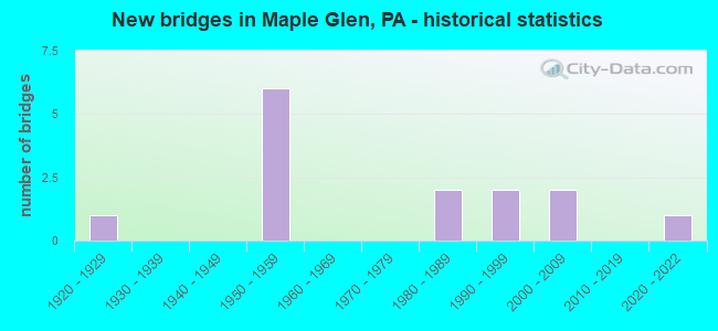
- New bridges - historical statistics
- 11920-1929
- 61950-1959
- 21980-1989
- 21990-1999
- 22000-2009
- 12020-2022
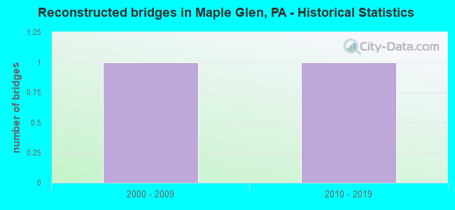
- Reconstructed bridges - Historical Statistics
- 12000-2009
- 12010-2019
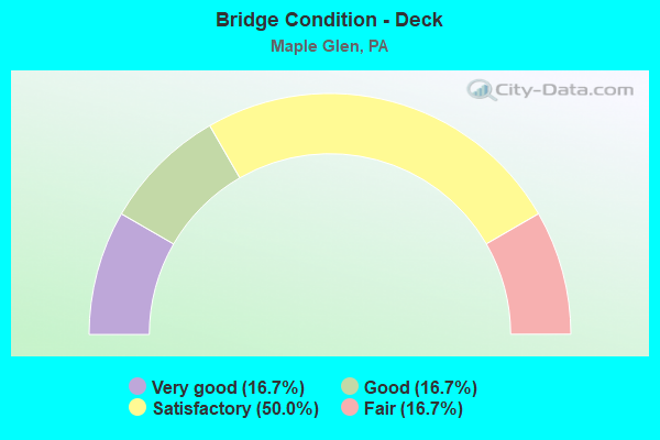
- Bridge Condition - Deck
- 16.7%Very good
- 16.7%Good
- 50.0%Satisfactory
- 16.7%Fair
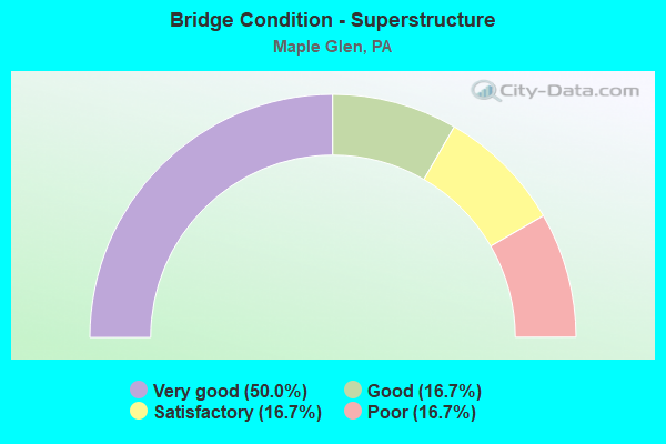
- Bridge Condition - Superstructure
- 50.0%Very good
- 16.7%Good
- 16.7%Satisfactory
- 16.7%Poor
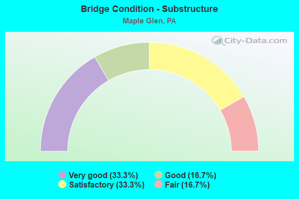
- Bridge Condition - Substructure
- 33.3%Very good
- 16.7%Good
- 33.3%Satisfactory
- 16.7%Fair
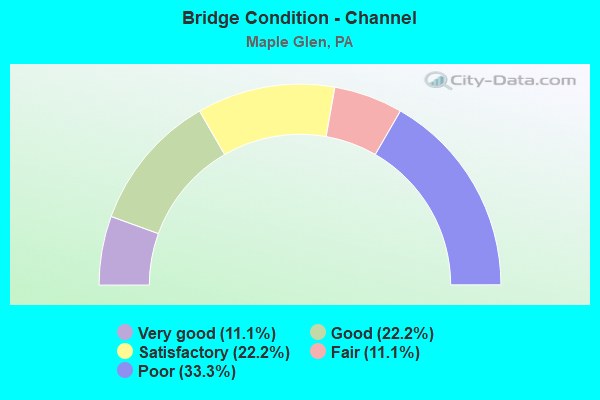
- Bridge Condition - Channel
- 11.1%Very good
- 22.2%Good
- 22.2%Satisfactory
- 11.1%Fair
- 33.3%Poor
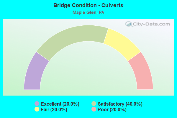
- Bridge Condition - Culverts
- 20.0%Excellent
- 40.0%Satisfactory
- 20.0%Fair
- 20.0%Poor
Find on map >> Show street view
Structure Number: 27319, Location: HORSHAM TWP. 24C5/3145K8 (Lat: 40.204506, Lng: -75.187503), Route carried "on" structure: State highway 152, Year Built: 1928, Status: Open, Structure Length: 1.01m (3.31ft), Average Daily Traffic: 9,813 (year 2022), Truck Traffic: 4%, Average Future Daily Traffic: 16,956 (year 2032), Design Load: H 20, Features Intersected: PARK CREEK, Facility Carried by Structure: LIMEKILN PIKE
Minimum Vertical Clearance: 30+ m (98+ ft), Kilometerpoint: 13.969, Lanes on structure: 2, Owner: State Highway Agency, Approaching Roadway Width: 9.1m (29.9ft), Material/Design: Concrete, Design/Construction: Tee Beam, Number Of Spans In Main Unit: 1, Length of Maximum Span: 9.8m (32.2ft), Curb-To-Curb Width: 6.8m (22.3ft), Out-to-Out Width: 8.0m (26.2ft)
Condition: Deck: Fair, Superstructure: Poor, Substructure: Satisfactory, Channel: Poor, Operating Rating: 55.3 metric tons, Method Used To Determine Operating Rating: Load Factor (LF), Inventory Rating: 32.7 metric tons, Method Used To Determine Inventory Rating: Load Factor (LF), Structural Evaluation: Meets minimum limits, Deck Geometry: High priority of replacement, Waterway Adequacy: Equal to present minimum criteria, Approach Roadway Alignment: Better than present minimum criteria, Length Of Structure Improvement: 1.60m (5.25ft), Designated Inspection Frequency: Every 24 months, Inspection Date: July 2020, Bridge Improvement Cost: $19,000, Roadway Improvement Cost: $55,000, Total Project Cost: $254,000, Deck Structure Type: Concrete Cast-file-Place, Wearing Surface/Protective System: Wearing Surface: Bituminous
Find on map >> Show street view
Structure Number: 27386, Location: UPPER DUBLIN 24A13 (Lat: 40.161919, Lng: -75.201433), Route carried "on" structure: State highway 309, Year Built: 1958, Year Reconstructed: 2006, Status: Open, Structure Length: 6.83m (22.41ft), Average Daily Traffic: 70,952 (year 2022), Truck Traffic: 5%, Average Future Daily Traffic: 71,414 (year 2032), Design Load: HS 25 or greater, Features Intersected: SUSQUEHANNA ROAD
Minimum Vertical Clearance: 30+ m (98+ ft), Kilometerpoint: 13.990, Lanes on structure: 2, Lanes under structure: 4, Base Highway Network: Yes, Owner: State Highway Agency, Approaching Roadway Width: 21.9m (71.9ft), Skew: 34 degrees, Material/Design: Steel continuous, Design/Construction: Girder and Floorbeam System, Number Of Spans In Main Unit: 3, Length of Maximum Span: 31.4m (103.0ft), Curb or Sidewalk Widths: Left: 0.2m (0.7ft), Right: 0.2m (0.7ft), Curb-To-Curb Width: 26.5m (86.9ft), Out-to-Out Width: 28.3m (92.8ft)
Condition: Deck: Very good, Superstructure: Very good, Substructure: Very good, Operating Rating: 69.9 metric tons, Method Used To Determine Operating Rating: Load Factor (LF), Inventory Rating: 41.7 metric tons, Method Used To Determine Inventory Rating: Load Factor (LF), Structural Evaluation: Equal to present desirable criteria, Deck Geometry: Superior to present desirable criteria, Underclear: Meets minimum limits, Approach Roadway Alignment: Equal to present desirable criteria, Length Of Structure Improvement: 7.60m (24.93ft), Designated Inspection Frequency: Every 24 months, Inspection Date: August 2020, Bridge Improvement Cost: $39,000, Roadway Improvement Cost: $114,000, Total Project Cost: $524,000, Deck Structure Type: Concrete Cast-file-Place, Wearing Surface/Protective System: Wearing Surface: Monolithic Concrete, Deck Protection: Epoxy Coated Reinforcing
Find on map >> Show street view
Structure Number: 27389, Location: UPPER DUBLIN 23K12/3257H4 (Lat: 40.166997, Lng: -75.204447), Route carried "on" structure: State highway 309, Year Built: 1958, Year Reconstructed: 2010, Status: Open, Structure Length: 4.51m (14.80ft), Average Daily Traffic: 70,952 (year 2022), Truck Traffic: 5%, Average Future Daily Traffic: 71,414 (year 2032), Design Load: HS 25 or greater, Features Intersected: BUTLER PIKE
Minimum Vertical Clearance: 30+ m (98+ ft), Kilometerpoint: 13.990, Lanes on structure: 3, Lanes under structure: 2, Base Highway Network: Yes, Owner: State Highway Agency, Approaching Roadway Width: 13.1m (43.0ft), Skew: 31 degrees, Material/Design: Steel continuous, Design/Construction: Stringer/Multi-beam, Number Of Spans In Main Unit: 3, Length of Maximum Span: 21.9m (71.9ft), Curb or Sidewalk Widths: Left: 0.1m (0.3ft), Right: 0.1m (0.3ft), Curb-To-Curb Width: 13.2m (43.3ft), Out-to-Out Width: 28.3m (92.8ft)
Condition: Deck: Good, Superstructure: Very good, Substructure: Very good, Inventory Rating: 66.2 metric tons, Method Used To Determine Inventory Rating: Load Factor (LF), Structural Evaluation: Equal to present desirable criteria, Deck Geometry: High priority of replacement, Underclear: Equal to present minimum criteria, Approach Roadway Alignment: Equal to present desirable criteria, Length Of Structure Improvement: 5.40m (17.72ft), Designated Inspection Frequency: Every 24 months, Inspection Date: August 2020, Bridge Improvement Cost: $28,000, Roadway Improvement Cost: $81,000, Total Project Cost: $373,000, Deck Structure Type: Concrete Cast-file-Place, Wearing Surface/Protective System: Wearing Surface: Monolithic Concrete, Deck Protection: Epoxy Coated Reinforcing
Find on map >> Show street view
Structure Number: 27455, Location: HORSHAM VALLET TWP.24D05 (Lat: 40.206353, Lng: -75.176161), Route carried "on" structure: State highway 463, Year Built: 1987, Status: Open, Structure Length: 1.55m (5.09ft), Average Daily Traffic: 12,761 (year 2021), Truck Traffic: 7%, Average Future Daily Traffic: 23,170 (year 2032), Design Load: HS 25 or greater, Features Intersected: PARK CREEK, Facility Carried by Structure: HORSHAM RD 3146B8
Minimum Vertical Clearance: 30+ m (98+ ft), Kilometerpoint: 15.815, Lanes on structure: 2, Owner: State Highway Agency, Approaching Roadway Width: 9.1m (29.9ft), Skew: 3 degrees, Material/Design: Prestressed concrete, Design/Construction: Box Beam or Girders - Multiple, Number Of Spans In Main Unit: 1, Length of Maximum Span: 15.2m (49.9ft), Curb or Sidewalk Widths: Left: 0.2m (0.7ft), Right: 0.2m (0.7ft), Curb-To-Curb Width: 12.4m (40.7ft), Out-to-Out Width: 13.9m (45.6ft)
Condition: Deck: Satisfactory, Superstructure: Good, Substructure: Fair, Channel: Poor, Operating Rating: 93.4 metric tons, Method Used To Determine Operating Rating: Load Factor (LF), Inventory Rating: 46.3 metric tons, Method Used To Determine Inventory Rating: Load Factor (LF), Structural Evaluation: Somewhat better than minimum adequacy, Deck Geometry: Somewhat better than minimum adequacy, Waterway Adequacy: Equal to present minimum criteria, Approach Roadway Alignment: Equal to present desirable criteria, Length Of Structure Improvement: 2.20m (7.22ft), Designated Inspection Frequency: Every 24 months, Underwater Inspection Frequency: Every 24 months, Inspection Date: June 2020, Underwater Inspection Date: June 2020, Deck Structure Type: Concrete Cast-file-Place, Wearing Surface/Protective System: Wearing Surface: Monolithic Concrete, Deck Protection: Epoxy Coated Reinforcing
Find on map >> Show street view
Structure Number: 27949, Location: CEDAR HILL;HORSHAM 3145J6 (Lat: 40.213733, Lng: -75.197472), Route carried "on" structure: City street , Year Built: 2003, Status: Open, Structure Length: 2.01m (6.59ft), Average Daily Traffic: 2,696 (year 2019), Truck Traffic: 30%, Average Future Daily Traffic: 2,561 (year 2018), Features Intersected: PARK CREEK, Facility Carried by Structure: CEDAR HILL ROAD
Minimum Vertical Clearance: 30+ m (98+ ft), Kilometerpoint: 0.000, Lanes on structure: 2, Owner: County Highway Agency, Approaching Roadway Width: 8.8m (28.9ft), Material/Design: Prestressed concrete, Design/Construction: Box Beam or Girders - Single/Spread, Number Of Spans In Main Unit: 1, Length of Maximum Span: 19.5m (64.0ft), Curb or Sidewalk Widths: Left: 0.2m (0.7ft), Right: 1.5m (4.9ft), Curb-To-Curb Width: 8.6m (28.2ft), Out-to-Out Width: 11.3m (37.1ft)
Condition: Deck: Satisfactory, Superstructure: Very good, Substructure: Good, Channel: Very good, Operating Rating: 68.0 metric tons, Method Used To Determine Operating Rating: Load Factor (LF), Inventory Rating: 23.6 metric tons, Method Used To Determine Inventory Rating: Load Factor (LF), Structural Evaluation: Equal to present minimum criteria, Deck Geometry: Meets minimum limits, Waterway Adequacy: Better than present minimum criteria, Approach Roadway Alignment: Equal to present desirable criteria, Length Of Structure Improvement: 2.40m (7.87ft), Designated Inspection Frequency: Every 24 months, Inspection Date: July 2020, Bridge Improvement Cost: $26,000, Roadway Improvement Cost: $78,000, Total Project Cost: $356,000, Deck Structure Type: Concrete Cast-file-Place, Wearing Surface/Protective System: Wearing Surface: Monolithic Concrete, Deck Protection: Epoxy Coated Reinforcing
Find on map >> Show street view
Structure Number: 28045, Location: 2.6MI.NE.FT.WASH. 3258-C5 (Lat: 40.159236, Lng: -75.173450), Route carried "on" structure: City street , Year Built: 1990, Status: Open, Structure Length: 0.73m (2.40ft), Average Daily Traffic: 140 (year 2013), Truck Traffic: 2%, Average Future Daily Traffic: 200 (year 2033), Features Intersected: TRIB. LITTLE PINE RUN, Facility Carried by Structure: LEXINGTON DRIVE
Minimum Vertical Clearance: 30+ m (98+ ft), Kilometerpoint: 0.000, Lanes on structure: 2, Owner: Town or Township Highway Agency, Approaching Roadway Width: 9.1m (29.9ft), Skew: 1 degrees, Material/Design: Concrete, Design/Construction: Culvert, Number Of Spans In Main Unit: 1, Length of Maximum Span: 7.0m (23.0ft), Curb or Sidewalk Widths: Left: 2.5m (8.2ft), Right: 2.4m (7.9ft)
Condition: Channel: Satisfactory, Culverts: Fair, Operating Rating: 81.6 metric tons, Method Used To Determine Operating Rating: Load Factor (LF), Inventory Rating: 49.0 metric tons, Method Used To Determine Inventory Rating: Load Factor (LF), Structural Evaluation: Somewhat better than minimum adequacy, Waterway Adequacy: Better than present minimum criteria, Approach Roadway Alignment: Equal to present desirable criteria, Length Of Structure Improvement: 1.30m (4.27ft), Designated Inspection Frequency: Every 24 months, Inspection Date: July 2019
Find on map >> Show street view
Structure Number: 28047, Location: 2.5MI.NE.FT EASH 3258-C5 (Lat: 40.157244, Lng: -75.172436), Route carried "on" structure: City street , Year Built: 1988, Status: Open, Structure Length: 0.76m (2.49ft), Average Daily Traffic: 100 (year 1991), Truck Traffic: 2%, Average Future Daily Traffic: 140 (year 2013), Design Load: HS 25 or greater, Features Intersected: TRIB. LITTLE PINE RUN, Facility Carried by Structure: LEXINGTON DRIVE
Minimum Vertical Clearance: 30+ m (98+ ft), Kilometerpoint: 0.000, Lanes on structure: 2, Owner: Town or Township Highway Agency, Approaching Roadway Width: 9.1m (29.9ft), Skew: 1 degrees, Material/Design: Concrete, Design/Construction: Culvert, Number Of Spans In Main Unit: 1, Length of Maximum Span: 7.0m (23.0ft), Curb or Sidewalk Widths: Left: 3.1m (10.2ft), Right: 3.1m (10.2ft), Curb-To-Curb Width: 9.1m (29.9ft), Out-to-Out Width: 16.0m (52.5ft)
Condition: Channel: Satisfactory, Culverts: Poor, Operating Rating: 45.4 metric tons, Method Used To Determine Operating Rating: Load Factor (LF), Inventory Rating: 26.3 metric tons, Method Used To Determine Inventory Rating: Load Factor (LF), Structural Evaluation: Meets minimum limits, Deck Geometry: Better than present minimum criteria, Waterway Adequacy: Equal to present desirable criteria, Approach Roadway Alignment: Equal to present desirable criteria, Length Of Structure Improvement: 1.00m (3.28ft), Designated Inspection Frequency: Every 24 months, Inspection Date: July 2019, Wearing Surface/Protective System: Wearing Surface: Bituminous
Find on map >> Show street view
Structure Number: 41077, Location: .4 Mi NE PA-463 3146-C7 (Lat: 40.209600, Lng: -75.168897), Route carried "on" structure: City street , Year Built: 1950, Status: Open, Structure Length: 0.73m (2.40ft), Average Daily Traffic: 6,550 (year 2013), Truck Traffic: 3%, Average Future Daily Traffic: 7,800 (year 2033), Features Intersected: TRIBUTARY PARK CREEK, Facility Carried by Structure: KEITH VALLEY ROAD
Minimum Vertical Clearance: 30+ m (98+ ft), Kilometerpoint: 0.000, Lanes on structure: 2, Owner: Town or Township Highway Agency, Approaching Roadway Width: 6.1m (20.0ft), Material/Design: Concrete, Design/Construction: Slab, Number Of Spans In Main Unit: 1, Length of Maximum Span: 6.4m (21.0ft), Curb-To-Curb Width: 6.1m (20.0ft), Out-to-Out Width: 7.0m (23.0ft)
Condition: Deck: Satisfactory, Superstructure: Satisfactory, Substructure: Satisfactory, Channel: Poor, Operating Rating: 76.2 metric tons, Method Used To Determine Operating Rating: Field evaluation and documented engineering judgment, Inventory Rating: 46.3 metric tons, Method Used To Determine Inventory Rating: Field evaluation and documented engineering judgment, Structural Evaluation: Equal to present minimum criteria, Deck Geometry: High priority of replacement, Waterway Adequacy: Equal to present minimum criteria, Approach Roadway Alignment: Equal to present desirable criteria, Length Of Structure Improvement: 0.90m (2.95ft), Designated Inspection Frequency: Every 24 months, Inspection Date: November 2020, Deck Structure Type: Concrete Cast-file-Place, Wearing Surface/Protective System: Wearing Surface: Bituminous
Find on map >> Show street view
Structure Number: 4108, Location: 500' NE PA-463 3146-D8 (Lat: 40.202475, Lng: -75.165997), Route carried "on" structure: City street , Year Built: 2000, Status: Open, Structure Length: 1.07m (3.51ft), Average Daily Traffic: 2,700 (year 2018), Truck Traffic: 1%, Average Future Daily Traffic: 3,000 (year 2038), Design Load: HS 20, Features Intersected: TRIBUTARY TO PARK CREEK, Facility Carried by Structure: BABYLON ROAD
Minimum Vertical Clearance: 30+ m (98+ ft), Kilometerpoint: 0.000, Lanes on structure: 2, Owner: Town or Township Highway Agency, Approaching Roadway Width: 7.9m (25.9ft), Material/Design: Concrete, Design/Construction: Culvert, Number Of Spans In Main Unit: 2, Length of Maximum Span: 5.5m (18.0ft), Curb or Sidewalk Widths: Left: 0.2m (0.7ft), Right: 0.2m (0.7ft), Curb-To-Curb Width: 7.9m (25.9ft), Out-to-Out Width: 8.9m (29.2ft)
Condition: Channel: Good, Culverts: Satisfactory, Operating Rating: 49.0 metric tons, Method Used To Determine Operating Rating: Field evaluation and documented engineering judgment, Inventory Rating: 32.7 metric tons, Method Used To Determine Inventory Rating: Field evaluation and documented engineering judgment, Structural Evaluation: Equal to present minimum criteria, Deck Geometry: High priority of corrective action, Waterway Adequacy: Equal to present minimum criteria, Approach Roadway Alignment: Equal to present desirable criteria, Length Of Structure Improvement: 1.90m (6.23ft), Designated Inspection Frequency: Every 24 months, Inspection Date: November 2020, Wearing Surface/Protective System: Wearing Surface: Bituminous
Find on map >> Show street view
Structure Number: 57158, Location: N OF CEDAR RD 3257H5 (Lat: 40.162389, Lng: -75.204500), Route carried "on" structure: Other road , Year Built: 1993, Status: Open, Structure Length: 0.94m (3.08ft), Average Daily Traffic: 25 (year 2019), Truck Traffic: 1%, Average Future Daily Traffic: 35 (year 2039), Design Load: HS 20, Features Intersected: TANNERY RUN, Facility Carried by Structure: FOREST CREEK DRIVE
Minimum Vertical Clearance: 30+ m (98+ ft), Kilometerpoint: 0.000, Lanes on structure: 2, Owner: Town or Township Highway Agency, Approaching Roadway Width: 9.1m (29.9ft), Material/Design: Concrete, Design/Construction: Culvert, Number Of Spans In Main Unit: 2, Length of Maximum Span: 4.3m (14.1ft), Curb-To-Curb Width: 9.2m (30.2ft), Out-to-Out Width: 12.2m (40.0ft)
Condition: Channel: Fair, Culverts: Satisfactory, Operating Rating: 63.5 metric tons, Method Used To Determine Operating Rating: Field evaluation and documented engineering judgment, Inventory Rating: 38.1 metric tons, Method Used To Determine Inventory Rating: Field evaluation and documented engineering judgment, Structural Evaluation: Equal to present minimum criteria, Deck Geometry: Better than present minimum criteria, Waterway Adequacy: Equal to present desirable criteria, Approach Roadway Alignment: Equal to present desirable criteria, Designated Inspection Frequency: Every 24 months, Inspection Date: November 2019, Wearing Surface/Protective System: Wearing Surface: Bituminous
Find on map >> Show street view
Structure Number: 68127, Location: 2000 FT NE SR463 3146-C7 (Lat: 40.210061, Lng: -75.171972), Route carried "on" structure: City street , Year Built: 2021, Status: Open, Structure Length: 1.28m (4.20ft), Average Daily Traffic: 1,682 (year 2020), Truck Traffic: 5%, Average Future Daily Traffic: 1,888 (year 2040), Design Load: HL 93, Features Intersected: PARK CREEK, Facility Carried by Structure: DAVIS GROVE ROAD
Minimum Vertical Clearance: 30+ m (98+ ft), Kilometerpoint: 0.000, Lanes on structure: 2, Owner: County Highway Agency, Approaching Roadway Width: 7.3m (24.0ft), Material/Design: Concrete, Design/Construction: Culvert, Number Of Spans In Main Unit: 1, Length of Maximum Span: 12.8m (42.0ft), Curb-To-Curb Width: 7.3m (24.0ft), Out-to-Out Width: 8.7m (28.5ft)
Condition: Channel: Good, Culverts: Excellent, Operating Rating: 55.1 metric tons, Method Used To Determine Operating Rating: Assigned ratings based on Load and Resistance Factor Design (LRFD) reported by rating factor (RF) using HL93 loadings, Inventory Rating: 42.1 metric tons, Method Used To Determine Inventory Rating: Assigned ratings based on Load and Resistance Factor Design (LRFD) reported by rating factor (RF) using HL93 loadings, Structural Evaluation: Superior to present desirable criteria, Deck Geometry: Meets minimum limits, Waterway Adequacy: Superior to present desirable criteria, Approach Roadway Alignment: Equal to present desirable criteria, Designated Inspection Frequency: Every 24 months, Inspection Date: April 2021
Find on map >> Show street view
Structure Number: 27386, Location: UPPER DUBLIN 24A13 (Lat: 40.161919, Lng: -75.201433), Route carried "under" structure: State highway , Year Built: 1958, Structure Length: 0. m, Average Daily Traffic: 6,571 (year 2022), Truck Traffic: 3%, Features Intersected: SUSQUEHANNA ROAD, Facility Carried by Structure: TRAFFIC ROUTE 309
Minimum Vertical Clearance: 4.37m (14.34ft), Kilometerpoint: 11.607, Lanes on structure: 2, Lanes under structure: 2, Material/Design: Steel continuous, Design/Construction: Girder and Floorbeam System, Length of Maximum Span: 31.4m (103.0ft)
Find on map >> Show street view
Structure Number: 27386, Location: UPPER DUBLIN 24A13 (Lat: 40.161919, Lng: -75.201433), Route carried "under" structure: State highway , Year Built: 1958, Structure Length: 0. m, Average Daily Traffic: 6,571 (year 2022), Truck Traffic: 3%, Features Intersected: SUSQUEHANNA ROAD, Facility Carried by Structure: TRAFFIC ROUTE 309
Minimum Vertical Clearance: 4.80m (15.75ft), Kilometerpoint: 11.607, Lanes on structure: 2, Lanes under structure: 2, Material/Design: Steel continuous, Design/Construction: Girder and Floorbeam System, Length of Maximum Span: 31.4m (103.0ft)
Find on map >> Show street view
Structure Number: 27389, Location: UPPER DUBLIN 23K12/3257H4 (Lat: 40.166997, Lng: -75.204447), Route carried "under" structure: County highway , Year Built: 1958, Structure Length: 0. m, Average Daily Traffic: 5,800 (year 1980), Features Intersected: BUTLER PIKE, Facility Carried by Structure: SR 309 BYPASS
Minimum Vertical Clearance: 4.55m (14.93ft), Kilometerpoint: 0.000, Lanes on structure: 3, Lanes under structure: 2, Material/Design: Steel continuous, Design/Construction: Stringer/Multi-beam, Length of Maximum Span: 21.9m (71.9ft)