Bridge Statistics for Marbletown, New York (NY)
Condition, Traffic, Stress, Structural Evaluation, Project Costs
- National Bridge Inventory (NBI) Statistics
- 11Number of bridges
- 128ft / 38.7mTotal length
- $38,145,000Total costs
- 18,117Total average daily traffic
- 1,152Total average daily truck traffic
- 20,572Total future (year 2037) average daily traffic
- National Bridge Inventory (NBI) Registered Bridges for Marbletown
- No street view available for this location
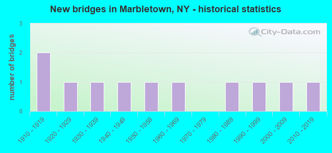
- New bridges - historical statistics
- 21910-1919
- 11920-1929
- 11930-1939
- 11940-1949
- 11950-1959
- 11960-1969
- 11980-1989
- 11990-1999
- 12000-2009
- 12010-2019

- Reconstructed bridges - Historical Statistics
- 11980-1989
- 11990-1999
- 12000-2009
- 12010-2019


- Bridge Condition - Deck
- 11.1%Excellent
- 11.1%Very good
- 22.2%Good
- 11.1%Satisfactory
- 22.2%Fair
- 22.2%Poor

- Bridge Condition - Superstructure
- 11.1%Excellent
- 11.1%Very good
- 11.1%Good
- 11.1%Satisfactory
- 33.3%Fair
- 22.2%Poor

- Bridge Condition - Substructure
- 11.1%Excellent
- 33.3%Good
- 22.2%Satisfactory
- 33.3%Fair

- Bridge Condition - Channel
- 18.2%Excellent
- 9.1%Very good
- 18.2%Good
- 36.4%Satisfactory
- 18.2%Poor
Find on map >> Show street view
Structure Number: 104077, Location: 8.9 MI N JCT RTS 209+44 (Lat: 41.830275, Lng: -74.178928), Route carried "on" structure: US 209, Year Built: 1963, Status: Open, Structure Length: 0.85m (2.79ft), Average Daily Traffic: 8,304 (year 2018), Truck Traffic: 7%, Average Future Daily Traffic: 8,382 (year 2040), Design Load: HS 20, Features Intersected: KRIPPLEBUSH CREEK
Minimum Vertical Clearance: 30+ m (98+ ft), Kilometerpoint: 31.778, Lanes on structure: 2, Base Highway Network: Yes, Owner: State Highway Agency, Approaching Roadway Width: 13.7m (44.9ft), Skew: 1 degrees, Material/Design: Concrete continuous, Design/Construction: Culvert, Number Of Spans In Main Unit: 2, Length of Maximum Span: 3.6m (11.8ft)
Condition: Channel: Satisfactory, Culverts: Satisfactory, Structural Evaluation: Equal to present minimum criteria, Waterway Adequacy: Superior to present desirable criteria, Approach Roadway Alignment: Equal to present desirable criteria, Length Of Structure Improvement: 0.85m (2.79ft), Designated Inspection Frequency: Every 24 months, Inspection Date: September 2021, Bridge Improvement Cost: $999,000, Roadway Improvement Cost: $585,000, Total Project Cost: $1,585,000 ( Estimate for 2021)
Find on map >> Show street view
Structure Number: 104115, Location: 3.2 MI E JCT RTS 213+209 (Lat: 41.828731, Lng: -74.133483), Route carried "on" structure: State highway 213, Year Built: 2017, Status: Open, Structure Length: 7.01m (23.00ft), Average Daily Traffic: 4,339 (year 2019), Truck Traffic: 6%, Average Future Daily Traffic: 4,526 (year 2040), Design Load: HL 93, Features Intersected: RONDOUT CREEK
Minimum Vertical Clearance: 32.69m (107.25ft), Kilometerpoint: 17.297, Lanes on structure: 2, Base Highway Network: Yes, Owner: State Highway Agency, Approaching Roadway Width: 8.5m (27.9ft), Material/Design: Steel, Design/Construction: Stringer/Multi-beam, Number Of Spans In Main Unit: 1, Length of Maximum Span: 68.3m (224.1ft), Curb or Sidewalk Widths: Left: 3.2m (10.5ft), Right: 0.0m, Curb-To-Curb Width: 11.0m (36.1ft), Out-to-Out Width: 15.2m (49.9ft)
Condition: Deck: Excellent, Superstructure: Excellent, Substructure: Excellent, Channel: Excellent, Operating Rating: 69.9 metric tons, Method Used To Determine Operating Rating: Load Factor (LF), Inventory Rating: 41.7 metric tons, Method Used To Determine Inventory Rating: Load Factor (LF), Structural Evaluation: Superior to present desirable criteria, Deck Geometry: Somewhat better than minimum adequacy, Waterway Adequacy: Meets minimum limits, Approach Roadway Alignment: Equal to present desirable criteria, Length Of Structure Improvement: 7.01m (23.00ft), Designated Inspection Frequency: Every 24 months, Underwater Inspection Frequency: Every 60 months, Inspection Date: September 2021, Underwater Inspection Date: August 2018, Bridge Improvement Cost: $4,034,000, Roadway Improvement Cost: $2,362,000, Total Project Cost: $6,396,000 ( Estimate for 2021), Deck Structure Type: Concrete Cast-file-Place, Wearing Surface/Protective System: Wearing Surface: Integral Concrete, Deck Protection: Epoxy Coated Reinforcing
Find on map >> Show street view
Structure Number: 202044, Location: .4MI N RTE28A AT SPILLWAY (Lat: 41.943453, Lng: -74.169678), Route carried "on" structure: Other road 28A, Year Built: 1912, Year Reconstructed: 2010, Status: Open, Structure Length: 8.41m (27.59ft), Average Daily Traffic: 485 (year 2016), Truck Traffic: 8%, Average Future Daily Traffic: 679 (year 2036), Design Load: HS 20, Features Intersected: ASHOKAN SPILLWAY
Minimum Vertical Clearance: 30+ m (98+ ft), Kilometerpoint: 19.308, Lanes on structure: 2, Base Highway Network: Yes, Owner: Local Agency, Approaching Roadway Width: 6.7m (22.0ft), Material/Design: Concrete, Design/Construction: Arch - Deck, Number Of Spans In Main Unit: 1, Number Of Approach Spans: 8, Length of Maximum Span: 53.3m (174.9ft), Curb-To-Curb Width: 7.3m (24.0ft), Out-to-Out Width: 9.1m (29.9ft)
Condition: Deck: Very good, Superstructure: Satisfactory, Substructure: Good, Channel: Very good, Operating Rating: 54.4 metric tons, Method Used To Determine Operating Rating: Load Factor (LF), Inventory Rating: 32.7 metric tons, Method Used To Determine Inventory Rating: Load Factor (LF), Structural Evaluation: Equal to present minimum criteria, Deck Geometry: Meets minimum limits, Waterway Adequacy: Equal to present minimum criteria, Approach Roadway Alignment: Equal to present minimum criteria, Length Of Structure Improvement: 8.41m (27.59ft), Designated Inspection Frequency: Every 24 months, Inspection Date: June 2021, Bridge Improvement Cost: $5,798,000, Roadway Improvement Cost: $3,395,000, Total Project Cost: $9,193,000 ( Estimate for 2021), Wearing Surface/Protective System: Wearing Surface: Monolithic Concrete
Find on map >> Show street view
Structure Number: 22243, Location: 0.9 MI SE OF KRIPPLEBUSH (Lat: 41.830964, Lng: -74.179172), Route carried "on" structure: Other road , Year Built: 1927, Status: Open, Structure Length: 0.85m (2.79ft), Truck Traffic: 1%, Features Intersected: KRIPPLEBUSH CREEK, Facility Carried by Structure: OLD ROUTE 209
Minimum Vertical Clearance: 30+ m (98+ ft), Kilometerpoint: 0.241, Lanes on structure: 2, Owner: Town or Township Highway Agency, Approaching Roadway Width: 6.1m (20.0ft), Skew: 1 degrees, Material/Design: Concrete, Design/Construction: Slab, Number Of Spans In Main Unit: 1, Length of Maximum Span: 7.9m (25.9ft), Curb-To-Curb Width: 9.2m (30.2ft), Out-to-Out Width: 10.0m (32.8ft)
Condition: Deck: Poor, Superstructure: Poor, Substructure: Fair, Channel: Poor, Operating Rating: 47.6 metric tons, Method Used To Determine Operating Rating: Field evaluation and documented engineering judgment, Inventory Rating: 13.7 metric tons, Method Used To Determine Inventory Rating: Field evaluation and documented engineering judgment, Structural Evaluation: Meets minimum limits, Deck Geometry: Better than present minimum criteria, Waterway Adequacy: Superior to present desirable criteria, Approach Roadway Alignment: Somewhat better than minimum adequacy, Length Of Structure Improvement: 0.85m (2.79ft), Designated Inspection Frequency: Every 24 months, Inspection Date: July 2021, Bridge Improvement Cost: $429,000, Roadway Improvement Cost: $251,000, Total Project Cost: $680,000 ( Estimate for 2021), Wearing Surface/Protective System: Wearing Surface: Bituminous
Find on map >> Show street view
Structure Number: 222432, Location: 2.5 MI E JCT SH 28A & SH2 (Lat: 41.932631, Lng: -74.169833), Route carried "on" structure: Other road , Year Built: 1911, Year Reconstructed: 2011, Status: Open, Structure Length: 6.16m (20.21ft), Average Daily Traffic: 176 (year 2019), Truck Traffic: 8%, Average Future Daily Traffic: 246 (year 2039), Design Load: HS 25 or greater, Features Intersected: SPILLWAY CHANNEL, Facility Carried by Structure: Stone Church Rd
Minimum Vertical Clearance: 30+ m (98+ ft), Kilometerpoint: 0.080, Lanes on structure: 2, Owner: Local Agency, Approaching Roadway Width: 7.6m (24.9ft), Material/Design: Concrete, Design/Construction: Arch - Deck, Number Of Spans In Main Unit: 1, Length of Maximum Span: 53.3m (174.9ft), Curb-To-Curb Width: 7.6m (24.9ft), Out-to-Out Width: 8.4m (27.6ft)
Condition: Deck: Good, Superstructure: Fair, Substructure: Good, Channel: Excellent, Operating Rating: 69.9 metric tons, Method Used To Determine Operating Rating: Load Factor (LF), Inventory Rating: 41.7 metric tons, Method Used To Determine Inventory Rating: Load Factor (LF), Structural Evaluation: Somewhat better than minimum adequacy, Deck Geometry: Somewhat better than minimum adequacy, Waterway Adequacy: Equal to present minimum criteria, Approach Roadway Alignment: Somewhat better than minimum adequacy, Length Of Structure Improvement: 6.15m (20.18ft), Designated Inspection Frequency: Every 24 months, Inspection Date: August 2020, Bridge Improvement Cost: $5,101,000, Roadway Improvement Cost: $2,987,000, Total Project Cost: $8,088,000 ( Estimate for 2021), Deck Structure Type: Concrete Cast-file-Place, Wearing Surface/Protective System: Wearing Surface: Integral Concrete, Deck Protection: Epoxy Coated Reinforcing
Find on map >> Show street view
Structure Number: 334639, Location: 2 MILES EAST OF ATWOOD (Lat: 41.887531, Lng: -74.123375), Route carried "on" structure: County highway , Year Built: 1988, Status: Open, Structure Length: 0.76m (2.49ft), Average Daily Traffic: 974 (year 2019), Truck Traffic: 5%, Average Future Daily Traffic: 1,364 (year 2039), Design Load: HS 20, Features Intersected: STONY CREEK, Facility Carried by Structure: HURLEY MOUNTAIN RO
Minimum Vertical Clearance: 30+ m (98+ ft), Kilometerpoint: 3.395, Lanes on structure: 2, Owner: County Highway Agency, Approaching Roadway Width: 7.3m (24.0ft), Skew: 2 degrees, Material/Design: Concrete, Design/Construction: Culvert, Number Of Spans In Main Unit: 2, Length of Maximum Span: 3.6m (11.8ft), Curb-To-Curb Width: 8.2m (26.9ft), Out-to-Out Width: 9.0m (29.5ft)
Condition: Channel: Satisfactory, Culverts: Satisfactory, Operating Rating: 74.8 metric tons, Method Used To Determine Operating Rating: Field evaluation and documented engineering judgment, Inventory Rating: 29.4 metric tons, Method Used To Determine Inventory Rating: Field evaluation and documented engineering judgment, Structural Evaluation: Equal to present minimum criteria, Deck Geometry: Somewhat better than minimum adequacy, Waterway Adequacy: Equal to present desirable criteria, Approach Roadway Alignment: Meets minimum limits, Length Of Structure Improvement: 0.76m (2.49ft), Designated Inspection Frequency: Every 24 months, Inspection Date: March 2020, Bridge Improvement Cost: $261,000, Roadway Improvement Cost: $153,000, Total Project Cost: $413,000 ( Estimate for 2021), Wearing Surface/Protective System: Wearing Surface: Bituminous
Find on map >> Show street view
Structure Number: 33466, Location: 2.6 MI SW OF STONE RIDGE (Lat: 41.824947, Lng: -74.169106), Route carried "on" structure: Other road , Year Built: 1990, Status: Open, Structure Length: 1.77m (5.81ft), Average Daily Traffic: 554 (year 2017), Truck Traffic: 8%, Average Future Daily Traffic: 776 (year 2037), Design Load: HS 20, Features Intersected: KRIPPLEBUSH CREEK, Facility Carried by Structure: KINGS HIGHWAY
Minimum Vertical Clearance: 30+ m (98+ ft), Kilometerpoint: 0.724, Lanes on structure: 2, Owner: County Highway Agency, Approaching Roadway Width: 7.3m (24.0ft), Material/Design: Steel, Design/Construction: Stringer/Multi-beam, Number Of Spans In Main Unit: 1, Length of Maximum Span: 17.3m (56.8ft), Curb-To-Curb Width: 7.7m (25.3ft), Out-to-Out Width: 7.9m (25.9ft)
Condition: Deck: Fair, Superstructure: Fair, Substructure: Satisfactory, Channel: Satisfactory, Operating Rating: 48.1 metric tons, Method Used To Determine Operating Rating: Load Factor (LF), Inventory Rating: 28.1 metric tons, Method Used To Determine Inventory Rating: Load Factor (LF), Structural Evaluation: Somewhat better than minimum adequacy, Deck Geometry: Meets minimum limits, Waterway Adequacy: Equal to present desirable criteria, Approach Roadway Alignment: Somewhat better than minimum adequacy, Length Of Structure Improvement: 1.76m (5.77ft), Designated Inspection Frequency: Every 24 months, Inspection Date: October 2020, Bridge Improvement Cost: $680,000, Roadway Improvement Cost: $398,000, Total Project Cost: $1,078,000 ( Estimate for 2021), Deck Structure Type: Wood or Timber, Wearing Surface/Protective System: Wearing Surface: Bituminous
Find on map >> Show street view
Structure Number: 334726, Location: 1.2 MI SE OF ATWOOD (Lat: 41.879064, Lng: -74.144803), Route carried "on" structure: County highway , Year Built: 1958, Status: Open, Structure Length: 8.23m (27.00ft), Average Daily Traffic: 974 (year 2019), Truck Traffic: 5%, Average Future Daily Traffic: 1,364 (year 2039), Design Load: H 20, Features Intersected: ESOPUS CREEK, Facility Carried by Structure: HURLEY MOUNTAIN RO
Minimum Vertical Clearance: 30+ m (98+ ft), Kilometerpoint: 1.239, Lanes on structure: 2, Owner: County Highway Agency, Approaching Roadway Width: 5.8m (19.0ft), Material/Design: Steel continuous, Design/Construction: Stringer/Multi-beam, Number Of Spans In Main Unit: 2, Length of Maximum Span: 40.2m (131.9ft), Curb or Sidewalk Widths: Left: 0.0m, Right: 1.2m (3.9ft), Curb-To-Curb Width: 7.9m (25.9ft), Out-to-Out Width: 10.1m (33.1ft)
Condition: Deck: Poor, Superstructure: Fair, Substructure: Fair, Channel: Good, Operating Rating: 50.8 metric tons, Method Used To Determine Operating Rating: Load Factor (LF), Inventory Rating: 29.9 metric tons, Method Used To Determine Inventory Rating: Load Factor (LF), Structural Evaluation: Somewhat better than minimum adequacy, Deck Geometry: Somewhat better than minimum adequacy, Waterway Adequacy: Superior to present desirable criteria, Approach Roadway Alignment: Somewhat better than minimum adequacy, Length Of Structure Improvement: 8.22m (26.97ft), Designated Inspection Frequency: Every 24 months, Inspection Date: July 2020, Bridge Improvement Cost: $4,314,000, Roadway Improvement Cost: $2,527,000, Total Project Cost: $6,841,000 ( Estimate for 2021), Deck Structure Type: Concrete Cast-file-Place, Wearing Surface/Protective System: Wearing Surface: Bituminous
Find on map >> Show street view
Structure Number: 33473, Location: 1.5 MI NW OF KRIPPLEBUSH (Lat: 41.847742, Lng: -74.218961), Route carried "on" structure: Other road , Year Built: 1938, Year Reconstructed: 1987, Status: Open, Structure Length: 1.10m (3.61ft), Average Daily Traffic: 361 (year 2019), Truck Traffic: 1%, Average Future Daily Traffic: 505 (year 2039), Design Load: HS 20, Features Intersected: NORTH PETERS KILL, Facility Carried by Structure: BONE HOLLOW ROAD
Minimum Vertical Clearance: 30+ m (98+ ft), Kilometerpoint: 4.441, Lanes on structure: 2, Owner: County Highway Agency, Approaching Roadway Width: 7.7m (25.3ft), Material/Design: Steel, Design/Construction: Stringer/Multi-beam, Number Of Spans In Main Unit: 1, Length of Maximum Span: 10.3m (33.8ft), Curb-To-Curb Width: 7.7m (25.3ft), Out-to-Out Width: 7.9m (25.9ft)
Condition: Deck: Fair, Superstructure: Poor, Substructure: Fair, Channel: Good, Operating Rating: 35.3 metric tons, Method Used To Determine Operating Rating: Load and Resistance Factor Rating (LRFR) rating reported by rating factor(RF) method using HL-93 loadings, Inventory Rating: 27.2 metric tons, Method Used To Determine Inventory Rating: Load and Resistance Factor Rating (LRFR) rating reported by rating factor(RF) method using HL-93 loadings, Structural Evaluation: Meets minimum limits, Deck Geometry: Somewhat better than minimum adequacy, Waterway Adequacy: Equal to present desirable criteria, Approach Roadway Alignment: Meets minimum limits, Length Of Structure Improvement: 1.09m (3.58ft), Designated Inspection Frequency: Every 24 months, Inspection Date: April 2021, Bridge Improvement Cost: $730,000, Roadway Improvement Cost: $427,000, Total Project Cost: $1,157,000 ( Estimate for 2021), Deck Structure Type: Wood or Timber, Wearing Surface/Protective System: Wearing Surface: Bituminous
Find on map >> Show street view
Structure Number: 334741, Location: 1.2 MI S OF HIGH FALLS (Lat: 41.810489, Lng: -74.132967), Route carried "on" structure: County highway , Year Built: 1941, Year Reconstructed: 1990, Status: Open, Structure Length: 1.92m (6.30ft), Average Daily Traffic: 765 (year 2018), Truck Traffic: 3%, Average Future Daily Traffic: 1,071 (year 2038), Design Load: HS 20, Features Intersected: COXING KILL, Facility Carried by Structure: CO RD 6A
Minimum Vertical Clearance: 30+ m (98+ ft), Kilometerpoint: 11.134, Lanes on structure: 2, Owner: County Highway Agency, Approaching Roadway Width: 7.6m (24.9ft), Skew: 4 degrees, Material/Design: Steel, Design/Construction: Stringer/Multi-beam, Number Of Spans In Main Unit: 1, Length of Maximum Span: 18.8m (61.7ft), Curb-To-Curb Width: 7.7m (25.3ft), Out-to-Out Width: 8.0m (26.2ft)
Condition: Deck: Satisfactory, Superstructure: Good, Substructure: Satisfactory, Channel: Satisfactory, Operating Rating: 52.6 metric tons, Method Used To Determine Operating Rating: Load Factor (LF), Inventory Rating: 30.8 metric tons, Method Used To Determine Inventory Rating: Load Factor (LF), Structural Evaluation: Equal to present minimum criteria, Deck Geometry: Meets minimum limits, Waterway Adequacy: Equal to present desirable criteria, Approach Roadway Alignment: Equal to present minimum criteria, Length Of Structure Improvement: 1.92m (6.30ft), Designated Inspection Frequency: Every 24 months, Inspection Date: April 2020, Bridge Improvement Cost: $976,000, Roadway Improvement Cost: $572,000, Total Project Cost: $1,547,000 ( Estimate for 2021), Deck Structure Type: Wood or Timber, Wearing Surface/Protective System: Wearing Surface: Bituminous
Find on map >> Show street view
Structure Number: 336521, Location: 1.4 MI E OF ALLIGERVILLE (Lat: 41.791850, Lng: -74.153039), Route carried "on" structure: County highway , Year Built: 2006, Status: Open, Structure Length: 1.68m (5.51ft), Average Daily Traffic: 1,185 (year 2018), Truck Traffic: 8%, Average Future Daily Traffic: 1,659 (year 2038), Design Load: HS 25 or greater, Features Intersected: COXING KILL, Facility Carried by Structure: COUNTY ROAD 6
Minimum Vertical Clearance: 30+ m (98+ ft), Kilometerpoint: 2.253, Lanes on structure: 2, Owner: County Highway Agency, Approaching Roadway Width: 6.7m (22.0ft), Material/Design: Steel, Design/Construction: Stringer/Multi-beam, Number Of Spans In Main Unit: 1, Length of Maximum Span: 15.8m (51.8ft), Curb-To-Curb Width: 7.7m (25.3ft), Out-to-Out Width: 8.5m (27.9ft)
Condition: Deck: Good, Superstructure: Very good, Substructure: Good, Channel: Poor, Operating Rating: 46.3 metric tons, Method Used To Determine Operating Rating: Load and Resistance Factor Rating (LRFR) rating reported by rating factor(RF) method using HL-93 loadings, Inventory Rating: 35.6 metric tons, Method Used To Determine Inventory Rating: Load and Resistance Factor Rating (LRFR) rating reported by rating factor(RF) method using HL-93 loadings, Structural Evaluation: Better than present minimum criteria, Deck Geometry: Meets minimum limits, Waterway Adequacy: Equal to present desirable criteria, Approach Roadway Alignment: Somewhat better than minimum adequacy, Length Of Structure Improvement: 1.67m (5.48ft), Designated Inspection Frequency: Every 24 months, Inspection Date: December 2020, Bridge Improvement Cost: $736,000, Roadway Improvement Cost: $431,000, Total Project Cost: $1,167,000 ( Estimate for 2021), Deck Structure Type: Corrugated Steel, Wearing Surface/Protective System: Wearing Surface: Bituminous, Membrane: Other