Bridge Statistics for Marcellus, New York (NY)
Condition, Traffic, Stress, Structural Evaluation, Project Costs
- National Bridge Inventory (NBI) Statistics
- 18Number of bridges
- 95ft / 29.3mTotal length
- $17,610,000Total costs
- 47,880Total average daily traffic
- 2,004Total average daily truck traffic
- National Bridge Inventory (NBI) Registered Bridges for Marcellus
- No street view available for this location
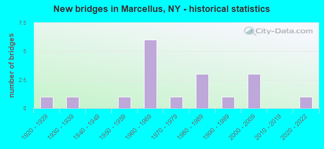
- New bridges - historical statistics
- 11920-1929
- 11930-1939
- 11950-1959
- 61960-1969
- 11970-1979
- 31980-1989
- 11990-1999
- 32000-2009
- 12020-2022


- Bridge Condition - Deck
- 25.0%Very good
- 25.0%Good
- 25.0%Satisfactory
- 25.0%Fair

- Bridge Condition - Superstructure
- 25.0%Very good
- 37.5%Good
- 12.5%Satisfactory
- 25.0%Fair

- Bridge Condition - Substructure
- 12.5%Very good
- 12.5%Good
- 75.0%Satisfactory

- Bridge Condition - Channel
- 6.3%Very good
- 12.5%Good
- 37.5%Satisfactory
- 37.5%Fair
- 6.3%Poor

- Bridge Condition - Culverts
- 22.2%Very good
- 33.3%Good
- 33.3%Satisfactory
- 11.1%Fair
Find on map >> Show street view
Structure Number: 101575, Location: 0.2 MI E JCT RTS 20 + 174 (Lat: 42.931003, Lng: -76.331303), Route carried "on" structure: US 20, Year Built: 1971, Status: Open, Structure Length: 1.07m (3.51ft), Average Daily Traffic: 3,447 (year 2018), Truck Traffic: 10%, Average Future Daily Traffic: 3,564 (year 2040), Design Load: HS 20, Features Intersected: NINEMILE CREEK
Minimum Vertical Clearance: 30+ m (98+ ft), Kilometerpoint: 10.780, Lanes on structure: 2, Base Highway Network: Yes, Owner: State Highway Agency, Approaching Roadway Width: 13.7m (44.9ft), Material/Design: Steel, Design/Construction: Culvert, Number Of Spans In Main Unit: 2, Length of Maximum Span: 5.1m (16.7ft)
Condition: Channel: Poor, Culverts: Fair, Operating Rating: 74.8 metric tons, Method Used To Determine Operating Rating: Field evaluation and documented engineering judgment, Inventory Rating: 19.6 metric tons, Method Used To Determine Inventory Rating: Field evaluation and documented engineering judgment, Structural Evaluation: Somewhat better than minimum adequacy, Waterway Adequacy: Somewhat better than minimum adequacy, Approach Roadway Alignment: Equal to present desirable criteria, Length Of Structure Improvement: 1.06m (3.48ft), Designated Inspection Frequency: Every 24 months, Inspection Date: August 2021, Bridge Improvement Cost: $339,000, Roadway Improvement Cost: $198,000, Total Project Cost: $537,000 ( Estimate for 2021)
Find on map >> Show street view
Structure Number: 103922, Location: 0.5 MI N JCT RTS 174 +175 (Lat: 42.991664, Lng: -76.339900), Route carried "on" structure: State highway 174, Year Built: 1966, Year Reconstructed: 2009, Status: Open, Structure Length: 3.02m (9.91ft), Average Daily Traffic: 3,316 (year 2020), Truck Traffic: 3%, Average Future Daily Traffic: 4,102 (year 2040), Design Load: HL 93, Features Intersected: NINE MILE CREEK
Minimum Vertical Clearance: 30+ m (98+ ft), Kilometerpoint: 18.761, Lanes on structure: 2, Base Highway Network: Yes, Owner: State Highway Agency, Approaching Roadway Width: 8.5m (27.9ft), Skew: 5 degrees, Material/Design: Steel, Design/Construction: Stringer/Multi-beam, Number Of Spans In Main Unit: 1, Length of Maximum Span: 28.3m (92.8ft), Curb or Sidewalk Widths: Left: 1.7m (5.6ft), Right: 1.7m (5.6ft), Curb-To-Curb Width: 8.5m (27.9ft), Out-to-Out Width: 12.9m (42.3ft)
Condition: Deck: Very good, Superstructure: Very good, Substructure: Very good, Channel: Good, Operating Rating: 84.0 metric tons, Method Used To Determine Operating Rating: Load Factor (LF), Inventory Rating: 50.0 metric tons, Method Used To Determine Inventory Rating: Load Factor (LF), Structural Evaluation: Equal to present desirable criteria, Deck Geometry: Meets minimum limits, Waterway Adequacy: Somewhat better than minimum adequacy, Approach Roadway Alignment: Equal to present desirable criteria, Length Of Structure Improvement: 3.13m (10.27ft), Designated Inspection Frequency: Every 24 months, Inspection Date: May 2021, Bridge Improvement Cost: $1,266,000, Roadway Improvement Cost: $741,000, Total Project Cost: $2,007,000 ( Estimate for 2021), Deck Structure Type: Concrete Cast-file-Place, Wearing Surface/Protective System: Wearing Surface: Integral Concrete, Deck Protection: Epoxy Coated Reinforcing
Find on map >> Show street view
Structure Number: 103923, Location: 1.1 MI N JCT RTS 174 +175 (Lat: 43.002986, Lng: -76.339731), Route carried "on" structure: State highway 174, Year Built: 2001, Status: Open, Structure Length: 1.34m (4.40ft), Average Daily Traffic: 3,316 (year 2020), Truck Traffic: 3%, Average Future Daily Traffic: 4,102 (year 2040), Design Load: HS 25 or greater, Features Intersected: NINEMILE CREEK
Minimum Vertical Clearance: 30+ m (98+ ft), Kilometerpoint: 20.048, Lanes on structure: 2, Base Highway Network: Yes, Owner: State Highway Agency, Approaching Roadway Width: 11.0m (36.1ft), Skew: 1 degrees, Material/Design: Concrete, Design/Construction: Frame, Number Of Spans In Main Unit: 1, Length of Maximum Span: 12.8m (42.0ft), Curb-To-Curb Width: 10.9m (35.8ft), Out-to-Out Width: 11.9m (39.0ft)
Condition: Deck: Good, Superstructure: Good, Substructure: Satisfactory, Channel: Satisfactory, Operating Rating: 89.8 metric tons, Method Used To Determine Operating Rating: Load Factor (LF), Inventory Rating: 58.1 metric tons, Method Used To Determine Inventory Rating: Load Factor (LF), Structural Evaluation: Equal to present minimum criteria, Deck Geometry: Somewhat better than minimum adequacy, Waterway Adequacy: Equal to present minimum criteria, Approach Roadway Alignment: Equal to present minimum criteria, Length Of Structure Improvement: 1.34m (4.40ft), Designated Inspection Frequency: Every 24 months, Inspection Date: July 2021, Bridge Improvement Cost: $1,036,000, Roadway Improvement Cost: $607,000, Total Project Cost: $1,643,000 ( Estimate for 2021)
Find on map >> Show street view
Structure Number: 103924, Location: 1.3 MI N JCT RTS 174 +175 (Lat: 43.004217, Lng: -76.338739), Route carried "on" structure: State highway 174, Year Built: 1966, Status: Open, Structure Length: 1.98m (6.50ft), Average Daily Traffic: 3,316 (year 2020), Truck Traffic: 3%, Average Future Daily Traffic: 4,102 (year 2040), Design Load: H 20, Features Intersected: NINE MILE CREEK
Minimum Vertical Clearance: 30+ m (98+ ft), Kilometerpoint: 20.209, Lanes on structure: 2, Base Highway Network: Yes, Owner: State Highway Agency, Approaching Roadway Width: 11.0m (36.1ft), Skew: 4 degrees, Material/Design: Concrete continuous, Design/Construction: Culvert, Number Of Spans In Main Unit: 2, Length of Maximum Span: 8.5m (27.9ft)
Condition: Channel: Satisfactory, Culverts: Good, Operating Rating: 68.1 metric tons, Method Used To Determine Operating Rating: Field evaluation and documented engineering judgment, Inventory Rating: 29.4 metric tons, Method Used To Determine Inventory Rating: Field evaluation and documented engineering judgment, Structural Evaluation: Better than present minimum criteria, Waterway Adequacy: Meets minimum limits, Approach Roadway Alignment: Equal to present desirable criteria, Length Of Structure Improvement: 1.98m (6.50ft), Designated Inspection Frequency: Every 24 months, Inspection Date: July 2021, Bridge Improvement Cost: $393,000, Roadway Improvement Cost: $230,000, Total Project Cost: $623,000 ( Estimate for 2021)
Find on map >> Show street view
Structure Number: 103925, Location: 1.5 MI N JCT RTS 174 +175 (Lat: 43.006119, Lng: -76.336919), Route carried "on" structure: State highway 174, Year Built: 1966, Status: Open, Structure Length: 1.46m (4.79ft), Average Daily Traffic: 3,316 (year 2020), Truck Traffic: 3%, Average Future Daily Traffic: 4,102 (year 2040), Design Load: HS 20, Features Intersected: NINEMILE CREEK
Minimum Vertical Clearance: 30+ m (98+ ft), Kilometerpoint: 20.466, Lanes on structure: 2, Base Highway Network: Yes, Owner: State Highway Agency, Approaching Roadway Width: 8.5m (27.9ft), Skew: 2 degrees, Material/Design: Concrete, Design/Construction: Culvert, Number Of Spans In Main Unit: 2, Length of Maximum Span: 6.0m (19.7ft), Curb-To-Curb Width: 11.0m (36.1ft), Out-to-Out Width: 11.9m (39.0ft)
Condition: Channel: Satisfactory, Culverts: Satisfactory, Operating Rating: 76.9 metric tons, Method Used To Determine Operating Rating: Field evaluation and documented engineering judgment, Inventory Rating: 32.7 metric tons, Method Used To Determine Inventory Rating: Field evaluation and documented engineering judgment, Structural Evaluation: Equal to present minimum criteria, Deck Geometry: Somewhat better than minimum adequacy, Waterway Adequacy: Somewhat better than minimum adequacy, Approach Roadway Alignment: Meets minimum limits, Length Of Structure Improvement: 1.46m (4.79ft), Designated Inspection Frequency: Every 24 months, Inspection Date: August 2021, Bridge Improvement Cost: $658,000, Roadway Improvement Cost: $385,000, Total Project Cost: $1,043,000 ( Estimate for 2021)
Find on map >> Show street view
Structure Number: 103927, Location: 0.6 MI SE JCT RTS 174+321 (Lat: 43.012361, Lng: -76.335933), Route carried "on" structure: State highway 174, Year Built: 1966, Status: Open, Structure Length: 1.55m (5.09ft), Average Daily Traffic: 3,316 (year 2020), Truck Traffic: 3%, Average Future Daily Traffic: 4,102 (year 2040), Design Load: HS 20, Features Intersected: NINEMILE CREEK
Minimum Vertical Clearance: 30+ m (98+ ft), Kilometerpoint: 21.207, Lanes on structure: 2, Base Highway Network: Yes, Owner: State Highway Agency, Approaching Roadway Width: 8.5m (27.9ft), Skew: 3 degrees, Material/Design: Concrete, Design/Construction: Culvert, Number Of Spans In Main Unit: 2, Length of Maximum Span: 6.0m (19.7ft)
Condition: Channel: Fair, Culverts: Good, Operating Rating: 76.9 metric tons, Method Used To Determine Operating Rating: Field evaluation and documented engineering judgment, Inventory Rating: 32.7 metric tons, Method Used To Determine Inventory Rating: Field evaluation and documented engineering judgment, Structural Evaluation: Better than present minimum criteria, Waterway Adequacy: Meets minimum limits, Approach Roadway Alignment: Meets minimum limits, Length Of Structure Improvement: 1.55m (5.09ft), Designated Inspection Frequency: Every 24 months, Inspection Date: July 2021, Bridge Improvement Cost: $392,000, Roadway Improvement Cost: $230,000, Total Project Cost: $622,000 ( Estimate for 2021), Wearing Surface/Protective System: Wearing Surface: Other
Find on map >> Show street view
Structure Number: 103928, Location: 0.4 MI SE JCT RTS 174+321 (Lat: 43.014011, Lng: -76.337164), Route carried "on" structure: State highway 174, Year Built: 1938, Status: Open, Structure Length: 1.34m (4.40ft), Average Daily Traffic: 3,316 (year 2020), Truck Traffic: 3%, Average Future Daily Traffic: 4,102 (year 2040), Design Load: H 20, Features Intersected: NINEMILE CREEK
Minimum Vertical Clearance: 30+ m (98+ ft), Kilometerpoint: 21.416, Lanes on structure: 2, Base Highway Network: Yes, Owner: State Highway Agency, Approaching Roadway Width: 8.5m (27.9ft), Skew: 4 degrees, Material/Design: Steel, Design/Construction: Stringer/Multi-beam, Number Of Spans In Main Unit: 1, Length of Maximum Span: 12.8m (42.0ft), Curb-To-Curb Width: 10.7m (35.1ft), Out-to-Out Width: 11.6m (38.1ft)
Condition: Deck: Satisfactory, Superstructure: Fair, Substructure: Good, Channel: Fair, Operating Rating: 88.9 metric tons, Method Used To Determine Operating Rating: Load Factor (LF), Inventory Rating: 53.5 metric tons, Method Used To Determine Inventory Rating: Load Factor (LF), Structural Evaluation: Somewhat better than minimum adequacy, Deck Geometry: Somewhat better than minimum adequacy, Waterway Adequacy: Meets minimum limits, Approach Roadway Alignment: Equal to present desirable criteria, Length Of Structure Improvement: 1.34m (4.40ft), Designated Inspection Frequency: Every 24 months, Inspection Date: July 2021, Bridge Improvement Cost: $599,000, Roadway Improvement Cost: $351,000, Total Project Cost: $950,000 ( Estimate for 2021), Deck Structure Type: Concrete Cast-file-Place, Wearing Surface/Protective System: Wearing Surface: Bituminous
Find on map >> Show street view
Structure Number: 104569, Location: 1.1 MI W JCT RTS 321 &174 (Lat: 43.022361, Lng: -76.362953), Route carried "on" structure: State highway 321, Year Built: 1985, Status: Open, Structure Length: 5.64m (18.50ft), Average Daily Traffic: 4,877 (year 2020), Truck Traffic: 8%, Average Future Daily Traffic: 6,818 (year 2040), Design Load: HS 20, Features Intersected: FINGER LAKES
Minimum Vertical Clearance: 30+ m (98+ ft), Kilometerpoint: 12.068, Lanes on structure: 2, Base Highway Network: Yes, Owner: State Highway Agency, Approaching Roadway Width: 12.2m (40.0ft), Skew: 3 degrees, Material/Design: Steel continuous, Design/Construction: Stringer/Multi-beam, Number Of Spans In Main Unit: 3, Length of Maximum Span: 24.3m (79.7ft), Curb-To-Curb Width: 12.1m (39.7ft), Out-to-Out Width: 13.0m (42.7ft)
Condition: Deck: Good, Superstructure: Good, Substructure: Satisfactory, Operating Rating: 79.8 metric tons, Method Used To Determine Operating Rating: Load Factor (LF), Inventory Rating: 47.2 metric tons, Method Used To Determine Inventory Rating: Load Factor (LF), Structural Evaluation: Equal to present minimum criteria, Deck Geometry: Somewhat better than minimum adequacy, Underclear: Equal to present minimum criteria, Approach Roadway Alignment: Equal to present desirable criteria, Length Of Structure Improvement: 5.63m (18.47ft), Designated Inspection Frequency: Every 24 months, Inspection Date: October 2021, Bridge Improvement Cost: $1,623,000, Roadway Improvement Cost: $951,000, Total Project Cost: $2,574,000 ( Estimate for 2021), Deck Structure Type: Concrete Cast-file-Place, Wearing Surface/Protective System: Wearing Surface: Integral Concrete, Deck Protection: Epoxy Coated Reinforcing
Find on map >> Show street view
Structure Number: 320793, Location: .9 MI SW JCT SHS174 & 175 (Lat: 42.958253, Lng: -76.340789), Route carried "on" structure: County highway , Year Built: 2002, Status: Open, Structure Length: 1.10m (3.61ft), Average Daily Traffic: 194 (year 2020), Truck Traffic: 8%, Average Future Daily Traffic: 272 (year 2040), Design Load: HS 25 or greater, Features Intersected: NINE MILE CREEK, Facility Carried by Structure: LAWRENCE ROAD
Minimum Vertical Clearance: 30+ m (98+ ft), Kilometerpoint: 1.802, Lanes on structure: 2, Owner: County Highway Agency, Approaching Roadway Width: 8.5m (27.9ft), Skew: 2 degrees, Material/Design: Prestressed concrete, Design/Construction: Box Beam or Girders - Multiple, Number Of Spans In Main Unit: 1, Length of Maximum Span: 9.4m (30.8ft), Curb-To-Curb Width: 8.5m (27.9ft), Out-to-Out Width: 9.1m (29.9ft)
Condition: Deck: Fair, Superstructure: Satisfactory, Substructure: Satisfactory, Channel: Satisfactory, Operating Rating: 84.4 metric tons, Method Used To Determine Operating Rating: Load Factor (LF), Inventory Rating: 49.9 metric tons, Method Used To Determine Inventory Rating: Load Factor (LF), Structural Evaluation: Equal to present minimum criteria, Deck Geometry: Equal to present minimum criteria, Waterway Adequacy: Somewhat better than minimum adequacy, Approach Roadway Alignment: Equal to present desirable criteria, Length Of Structure Improvement: 1.09m (3.58ft), Designated Inspection Frequency: Every 24 months, Inspection Date: October 2020, Bridge Improvement Cost: $438,000, Roadway Improvement Cost: $256,000, Total Project Cost: $694,000 ( Estimate for 2021), Wearing Surface/Protective System: Wearing Surface: Bituminous
Find on map >> Show street view
Structure Number: 320817, Location: 1 MI N OF MARIETTA (Lat: 42.920953, Lng: -76.329797), Route carried "on" structure: Other road , Year Built: 1952, Year Reconstructed: 2008, Status: Open, Structure Length: 1.04m (3.41ft), Average Daily Traffic: 67 (year 2019), Truck Traffic: 8%, Average Future Daily Traffic: 94 (year 2039), Features Intersected: NINE MILE CREEK, Facility Carried by Structure: SCHUYLER ROAD
Minimum Vertical Clearance: 30+ m (98+ ft), Kilometerpoint: 0.306, Lanes on structure: 2, Owner: County Highway Agency, Approaching Roadway Width: 7.6m (24.9ft), Material/Design: Prestressed concrete, Design/Construction: Box Beam or Girders - Multiple, Number Of Spans In Main Unit: 1, Length of Maximum Span: 9.8m (32.2ft), Curb-To-Curb Width: 7.7m (25.3ft), Out-to-Out Width: 8.7m (28.5ft)
Condition: Deck: Very good, Superstructure: Very good, Substructure: Satisfactory, Channel: Satisfactory, Operating Rating: 71.7 metric tons, Method Used To Determine Operating Rating: Load Factor (LF), Inventory Rating: 42.6 metric tons, Method Used To Determine Inventory Rating: Load Factor (LF), Structural Evaluation: Equal to present minimum criteria, Deck Geometry: Equal to present minimum criteria, Waterway Adequacy: Somewhat better than minimum adequacy, Approach Roadway Alignment: Equal to present desirable criteria, Length Of Structure Improvement: 1.03m (3.38ft), Designated Inspection Frequency: Every 24 months, Inspection Date: October 2020, Bridge Improvement Cost: $466,000, Roadway Improvement Cost: $273,000, Total Project Cost: $739,000 ( Estimate for 2021), Wearing Surface/Protective System: Wearing Surface: Bituminous, Membrane: Other
Find on map >> Show street view
Structure Number: 320818, Location: .3 MI N JCT SH174 & SH175 (Lat: 42.966994, Lng: -76.337300), Route carried "on" structure: Alternate State highway 174, Year Built: 1983, Status: Open, Structure Length: 2.71m (8.89ft), Average Daily Traffic: 1,782 (year 2020), Truck Traffic: 3%, Average Future Daily Traffic: 2,204 (year 2040), Design Load: HS 20+Mod, Features Intersected: NINE MILE CREEK
Minimum Vertical Clearance: 30+ m (98+ ft), Kilometerpoint: 0.451, Lanes on structure: 2, Owner: County Highway Agency, Approaching Roadway Width: 10.4m (34.1ft), Skew: 4 degrees, Material/Design: Prestressed concrete, Design/Construction: Box Beam or Girders - Multiple, Number Of Spans In Main Unit: 1, Length of Maximum Span: 24.3m (79.7ft), Curb-To-Curb Width: 10.4m (34.1ft), Out-to-Out Width: 11.3m (37.1ft)
Condition: Deck: Satisfactory, Superstructure: Fair, Substructure: Satisfactory, Channel: Fair, Operating Rating: 74.4 metric tons, Method Used To Determine Operating Rating: Load Factor (LF), Inventory Rating: 28.1 metric tons, Method Used To Determine Inventory Rating: Load Factor (LF), Structural Evaluation: Somewhat better than minimum adequacy, Deck Geometry: Equal to present minimum criteria, Waterway Adequacy: Equal to present desirable criteria, Approach Roadway Alignment: Better than present minimum criteria, Length Of Structure Improvement: 2.71m (8.89ft), Designated Inspection Frequency: Every 24 months, Inspection Date: May 2020, Bridge Improvement Cost: $1,379,000, Roadway Improvement Cost: $808,000, Total Project Cost: $2,187,000 ( Estimate for 2021), Wearing Surface/Protective System: Wearing Surface: Bituminous, Membrane: Other
Find on map >> Show street view
Structure Number: 331304, Location: NEXT TO MARCELLUS PARK (Lat: 42.975217, Lng: -76.337231), Route carried "on" structure: County highway , Year Built: 1989, Status: Open, Structure Length: 1.68m (5.51ft), Average Daily Traffic: 859 (year 2017), Truck Traffic: 4%, Average Future Daily Traffic: 1,203 (year 2037), Features Intersected: NINEMILE CREEK, Facility Carried by Structure: CR150A PLATT ROAD
Minimum Vertical Clearance: 30+ m (98+ ft), Kilometerpoint: 0.225, Lanes on structure: 2, Owner: County Highway Agency, Approaching Roadway Width: 9.4m (30.8ft), Skew: 2 degrees, Material/Design: Steel, Design/Construction: Stringer/Multi-beam, Number Of Spans In Main Unit: 1, Length of Maximum Span: 16.1m (52.8ft), Curb-To-Curb Width: 10.4m (34.1ft), Out-to-Out Width: 11.2m (36.7ft)
Condition: Deck: Fair, Superstructure: Good, Substructure: Satisfactory, Channel: Fair, Operating Rating: 49.0 metric tons, Method Used To Determine Operating Rating: Load Factor (LF), Inventory Rating: 29.0 metric tons, Method Used To Determine Inventory Rating: Load Factor (LF), Structural Evaluation: Equal to present minimum criteria, Deck Geometry: Equal to present minimum criteria, Waterway Adequacy: Meets minimum limits, Approach Roadway Alignment: Equal to present desirable criteria, Length Of Structure Improvement: 1.67m (5.48ft), Designated Inspection Frequency: Every 24 months, Inspection Date: August 2020, Bridge Improvement Cost: $634,000, Roadway Improvement Cost: $371,000, Total Project Cost: $1,005,000 ( Estimate for 2021), Deck Structure Type: Concrete Cast-file-Place, Wearing Surface/Protective System: Wearing Surface: Bituminous, Membrane: Other
Find on map >> Show street view
Structure Number: 331306, Location: 2.5 MI SOUTH OF MARCELLUS (Lat: 42.952431, Lng: -76.351842), Route carried "on" structure: County highway , Year Built: 2020, Status: Open, Structure Length: 0.70m (2.30ft), Average Daily Traffic: 563 (year 2017), Truck Traffic: 8%, Average Future Daily Traffic: 788 (year 2037), Design Load: HL 93, Features Intersected: WEST NINE MILE CK, Facility Carried by Structure: BISHOP HILL ROAD
Minimum Vertical Clearance: 30+ m (98+ ft), Kilometerpoint: 2.253, Lanes on structure: 2, Owner: County Highway Agency, Approaching Roadway Width: 9.8m (32.2ft), Material/Design: Concrete, Design/Construction: Culvert, Number Of Spans In Main Unit: 1, Length of Maximum Span: 6.4m (21.0ft), Curb-To-Curb Width: 9.8m (32.2ft), Out-to-Out Width: 10.8m (35.4ft)
Condition: Channel: Very good, Culverts: Very good, Operating Rating: 77.1 metric tons, Method Used To Determine Operating Rating: Field evaluation and documented engineering judgment, Inventory Rating: 40.8 metric tons, Method Used To Determine Inventory Rating: Field evaluation and documented engineering judgment, Structural Evaluation: Equal to present desirable criteria, Deck Geometry: Equal to present minimum criteria, Waterway Adequacy: Meets minimum limits, Approach Roadway Alignment: Equal to present desirable criteria, Length Of Structure Improvement: 0.70m (2.30ft), Designated Inspection Frequency: Every 24 months, Inspection Date: March 2021, Bridge Improvement Cost: $174,000, Roadway Improvement Cost: $102,000, Total Project Cost: $276,000 ( Estimate for 2021), Wearing Surface/Protective System: Wearing Surface: Bituminous, Membrane: Other
Find on map >> Show street view
Structure Number: 331307, Location: 2.3 MI S MARCELLUS VIL (Lat: 42.948783, Lng: -76.338192), Route carried "on" structure: County highway , Year Built: 1991, Status: Open, Structure Length: 1.16m (3.81ft), Average Daily Traffic: 53 (year 2017), Truck Traffic: 8%, Average Future Daily Traffic: 74 (year 2037), Features Intersected: NINEMILE CREEK, Facility Carried by Structure: MASTERS RD
Minimum Vertical Clearance: 30+ m (98+ ft), Kilometerpoint: 3.138, Lanes on structure: 2, Owner: County Highway Agency, Approaching Roadway Width: 10.4m (34.1ft), Material/Design: Aluminum, Iron, Design/Construction: Culvert, Number Of Spans In Main Unit: 2, Length of Maximum Span: 4.8m (15.7ft), Curb-To-Curb Width: 10.6m (34.8ft), Out-to-Out Width: 11.3m (37.1ft)
Condition: Channel: Fair, Culverts: Good, Operating Rating: 76.0 metric tons, Method Used To Determine Operating Rating: Field evaluation and documented engineering judgment, Inventory Rating: 32.7 metric tons, Method Used To Determine Inventory Rating: Field evaluation and documented engineering judgment, Structural Evaluation: Better than present minimum criteria, Deck Geometry: Superior to present desirable criteria, Waterway Adequacy: Meets minimum limits, Approach Roadway Alignment: High priority of corrective action, Length Of Structure Improvement: 1.15m (3.77ft), Designated Inspection Frequency: Every 24 months, Inspection Date: August 2020, Bridge Improvement Cost: $303,000, Roadway Improvement Cost: $177,000, Total Project Cost: $480,000 ( Estimate for 2021), Wearing Surface/Protective System: Wearing Surface: Bituminous
Find on map >> Show street view
Structure Number: 331308, Location: .3 MI E Marcellus on 175 (Lat: 42.982650, Lng: -76.335258), Route carried "on" structure: County highway 174, Year Built: 2004, Status: Open, Structure Length: 1.04m (3.41ft), Average Daily Traffic: 4,929 (year 2020), Truck Traffic: 5%, Average Future Daily Traffic: 6,098 (year 2040), Design Load: HS 25 or greater, Features Intersected: NINE MILE CREEK
Minimum Vertical Clearance: 30+ m (98+ ft), Kilometerpoint: 17.345, Lanes on structure: 2, Base Highway Network: Yes, Owner: County Highway Agency, Approaching Roadway Width: 9.4m (30.8ft), Material/Design: Concrete, Design/Construction: Culvert, Number Of Spans In Main Unit: 1, Length of Maximum Span: 9.8m (32.2ft), Curb or Sidewalk Widths: Left: 1.7m (5.6ft), Right: 1.7m (5.6ft), Curb-To-Curb Width: 9.6m (31.5ft), Out-to-Out Width: 14.0m (45.9ft)
Condition: Channel: Good, Culverts: Very good, Operating Rating: 79.5 metric tons, Method Used To Determine Operating Rating: Field evaluation and documented engineering judgment, Inventory Rating: 40.8 metric tons, Method Used To Determine Inventory Rating: Field evaluation and documented engineering judgment, Structural Evaluation: Equal to present desirable criteria, Deck Geometry: Meets minimum limits, Waterway Adequacy: Somewhat better than minimum adequacy, Approach Roadway Alignment: Equal to present desirable criteria, Length Of Structure Improvement: 1.03m (3.38ft), Designated Inspection Frequency: Every 24 months, Inspection Date: October 2020, Bridge Improvement Cost: $376,000, Roadway Improvement Cost: $220,000, Total Project Cost: $596,000 ( Estimate for 2021)
Find on map >> Show street view
Structure Number: 33658, Location: 0.6 MI-SW-JCT-RTS 175&174 (Lat: 42.952400, Lng: -76.349711), Route carried "on" structure: County highway 175, Year Built: 1962, Status: Open, Structure Length: 1.13m (3.71ft), Average Daily Traffic: 3,445 (year 2018), Truck Traffic: 4%, Average Future Daily Traffic: 3,466 (year 2040), Design Load: HS 20, Features Intersected: WEST NINE MILE CK
Minimum Vertical Clearance: 30+ m (98+ ft), Kilometerpoint: 3.862, Lanes on structure: 2, Base Highway Network: Yes, Owner: County Highway Agency, Approaching Roadway Width: 12.2m (40.0ft), Skew: 2 degrees, Material/Design: Concrete continuous, Design/Construction: Culvert, Number Of Spans In Main Unit: 2, Length of Maximum Span: 5.1m (16.7ft)
Condition: Channel: Fair, Culverts: Satisfactory, Operating Rating: 76.2 metric tons, Method Used To Determine Operating Rating: Field evaluation and documented engineering judgment, Inventory Rating: 32.7 metric tons, Method Used To Determine Inventory Rating: Field evaluation and documented engineering judgment, Structural Evaluation: Equal to present minimum criteria, Waterway Adequacy: Equal to present desirable criteria, Approach Roadway Alignment: Equal to present desirable criteria, Length Of Structure Improvement: 1.12m (3.67ft), Designated Inspection Frequency: Every 24 months, Inspection Date: April 2020, Bridge Improvement Cost: $319,000, Roadway Improvement Cost: $187,000, Total Project Cost: $505,000 ( Estimate for 2021), Wearing Surface/Protective System: Wearing Surface: Bituminous
Find on map >> Show street view
Structure Number: 336581, Location: 1.1 MI SW JCT SH175 & SH1 (Lat: 42.956214, Lng: -76.341681), Route carried "on" structure: County highway 175, Year Built: 1962, Status: Open, Structure Length: 1.31m (4.30ft), Average Daily Traffic: 3,445 (year 2018), Truck Traffic: 4%, Average Future Daily Traffic: 3,466 (year 2040), Design Load: HS 20, Features Intersected: NINE MILE CREEK
Minimum Vertical Clearance: 30+ m (98+ ft), Kilometerpoint: 4.650, Lanes on structure: 2, Base Highway Network: Yes, Owner: County Highway Agency, Approaching Roadway Width: 12.2m (40.0ft), Skew: 2 degrees, Material/Design: Concrete continuous, Design/Construction: Culvert, Number Of Spans In Main Unit: 2, Length of Maximum Span: 6.4m (21.0ft)
Condition: Channel: Satisfactory, Culverts: Satisfactory, Operating Rating: 77.1 metric tons, Method Used To Determine Operating Rating: Field evaluation and documented engineering judgment, Inventory Rating: 32.7 metric tons, Method Used To Determine Inventory Rating: Field evaluation and documented engineering judgment, Structural Evaluation: Equal to present minimum criteria, Waterway Adequacy: Meets minimum limits, Approach Roadway Alignment: Equal to present desirable criteria, Length Of Structure Improvement: 1.31m (4.30ft), Designated Inspection Frequency: Every 24 months, Inspection Date: June 2020, Bridge Improvement Cost: $712,000, Roadway Improvement Cost: $417,000, Total Project Cost: $1,129,000 ( Estimate for 2021), Wearing Surface/Protective System: Wearing Surface: Bituminous
Find on map >> Show street view
Structure Number: 703929, Location: 0.2 MI S JCT RTS 174 +321 (Lat: 43.016906, Lng: -76.339911), Route carried "under" structure: State highway 174, Year Built: 1921, Structure Length: 0. m, Average Daily Traffic: 4,323 (year 2002), Features Intersected: RTE 174, Facility Carried by Structure: FINGER LAKES
Minimum Vertical Clearance: 7.41m (24.31ft), Kilometerpoint: 21.142, Lanes under structure: 2, Material/Design: Concrete, Design/Construction: Arch - Deck, Length of Maximum Span: 8.5m (27.9ft)