Bridge Statistics for Marcy, New York (NY)
Condition, Traffic, Stress, Structural Evaluation, Project Costs
- National Bridge Inventory (NBI) Statistics
- 47Number of bridges
- 499ft / 152mTotal length
- $77,870,000Total costs
- 362,192Total average daily traffic
- 25,644Total average daily truck traffic
- National Bridge Inventory (NBI) Registered Bridges for Marcy
- No street view available for this location
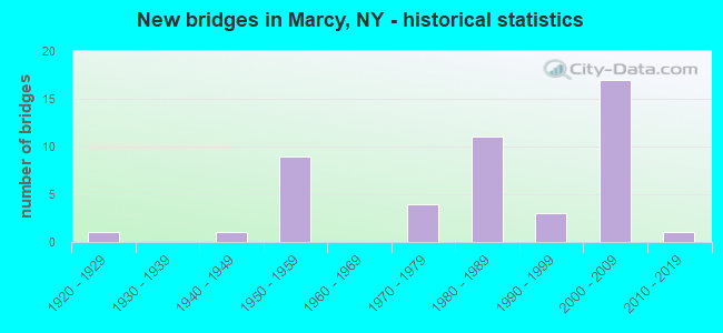
- New bridges - historical statistics
- 11920-1929
- 11940-1949
- 91950-1959
- 41970-1979
- 111980-1989
- 31990-1999
- 172000-2009
- 12010-2019
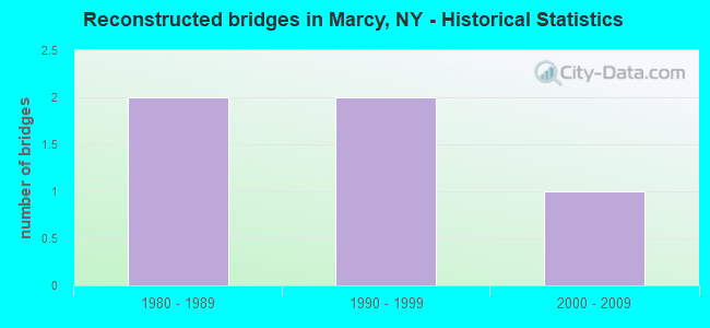
- Reconstructed bridges - Historical Statistics
- 21980-1989
- 21990-1999
- 12000-2009
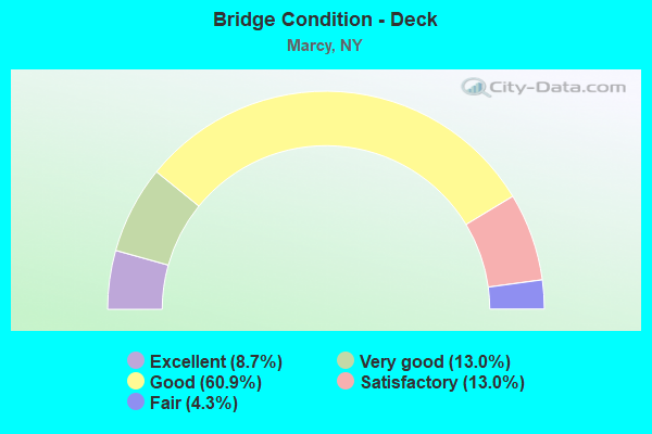
- Bridge Condition - Deck
- 8.7%Excellent
- 13.0%Very good
- 60.9%Good
- 13.0%Satisfactory
- 4.3%Fair
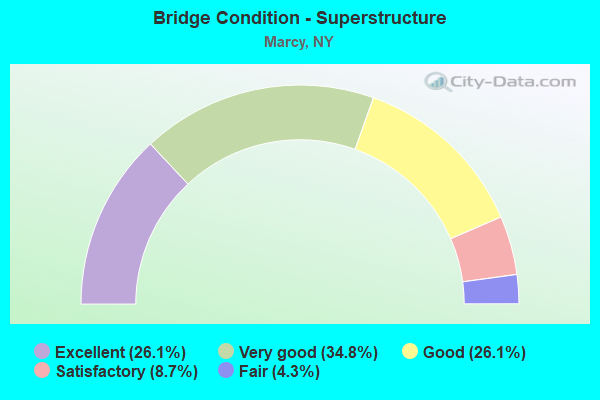
- Bridge Condition - Superstructure
- 26.1%Excellent
- 34.8%Very good
- 26.1%Good
- 8.7%Satisfactory
- 4.3%Fair
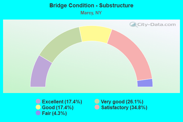
- Bridge Condition - Substructure
- 17.4%Excellent
- 26.1%Very good
- 17.4%Good
- 34.8%Satisfactory
- 4.3%Fair
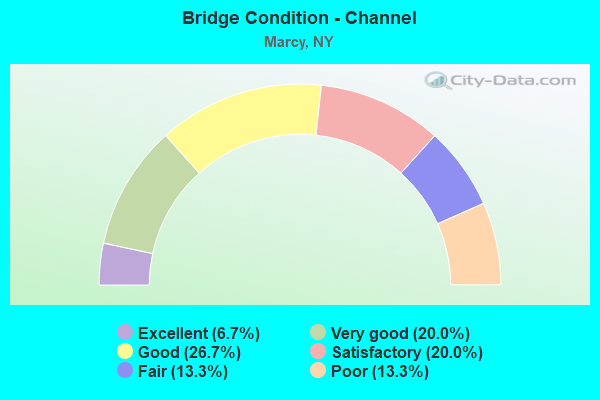
- Bridge Condition - Channel
- 6.7%Excellent
- 20.0%Very good
- 26.7%Good
- 20.0%Satisfactory
- 13.3%Fair
- 13.3%Poor
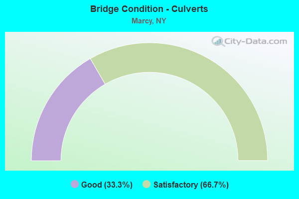
- Bridge Condition - Culverts
- 33.3%Good
- 66.7%Satisfactory
Find on map >> Show street view
Structure Number: 1026261, Location: 4.4 MI E JCT RTS 365 & 46 (Lat: 43.182089, Lng: -75.333194), Route carried "on" structure: State highway 49, Year Built: 1998, Status: Open, Structure Length: 5.88m (19.29ft), Average Daily Traffic: 8,542 (year 2020), Truck Traffic: 10%, Average Future Daily Traffic: 10,660 (year 2040), Design Load: HS 25 or greater, Features Intersected: NINE MILE CREEK
Minimum Vertical Clearance: 30+ m (98+ ft), Kilometerpoint: 50.973, Lanes on structure: 2, Base Highway Network: Yes, Owner: State Highway Agency, Approaching Roadway Width: 11.3m (37.1ft), Material/Design: Steel, Design/Construction: Stringer/Multi-beam, Number Of Spans In Main Unit: 1, Length of Maximum Span: 57.6m (189.0ft), Curb-To-Curb Width: 11.4m (37.4ft), Out-to-Out Width: 12.3m (40.4ft)
Condition: Deck: Good, Superstructure: Very good, Substructure: Very good, Channel: Very good, Operating Rating: 72.6 metric tons, Method Used To Determine Operating Rating: Load Factor (LF), Inventory Rating: 43.5 metric tons, Method Used To Determine Inventory Rating: Load Factor (LF), Structural Evaluation: Equal to present desirable criteria, Deck Geometry: Somewhat better than minimum adequacy, Waterway Adequacy: Equal to present minimum criteria, Approach Roadway Alignment: Equal to present desirable criteria, Length Of Structure Improvement: 5.88m (19.29ft), Designated Inspection Frequency: Every 24 months, Inspection Date: September 2020, Bridge Improvement Cost: $1,381,000, Roadway Improvement Cost: $809,000, Total Project Cost: $2,189,000 ( Estimate for 2021), Deck Structure Type: Concrete Cast-file-Place, Wearing Surface/Protective System: Wearing Surface: Integral Concrete, Deck Protection: Epoxy Coated Reinforcing
Find on map >> Show street view
Structure Number: 1026262, Location: 4.4 MI E JCT RTS 365 & 46 (Lat: 43.182017, Lng: -75.333342), Route carried "on" structure: State highway 49, Year Built: 1998, Status: Open, Structure Length: 5.88m (19.29ft), Average Daily Traffic: 8,542 (year 2020), Truck Traffic: 10%, Average Future Daily Traffic: 10,660 (year 2040), Design Load: HS 25 or greater, Features Intersected: NINE MILE CREEK
Minimum Vertical Clearance: 30+ m (98+ ft), Kilometerpoint: 50.973, Lanes on structure: 2, Base Highway Network: Yes, Owner: State Highway Agency, Approaching Roadway Width: 11.3m (37.1ft), Material/Design: Steel, Design/Construction: Stringer/Multi-beam, Number Of Spans In Main Unit: 1, Length of Maximum Span: 57.6m (189.0ft), Curb-To-Curb Width: 11.4m (37.4ft), Out-to-Out Width: 12.3m (40.4ft)
Condition: Deck: Good, Superstructure: Very good, Substructure: Very good, Channel: Very good, Operating Rating: 72.6 metric tons, Method Used To Determine Operating Rating: Load Factor (LF), Inventory Rating: 43.5 metric tons, Method Used To Determine Inventory Rating: Load Factor (LF), Structural Evaluation: Equal to present desirable criteria, Deck Geometry: Somewhat better than minimum adequacy, Waterway Adequacy: Equal to present minimum criteria, Approach Roadway Alignment: Equal to present desirable criteria, Length Of Structure Improvement: 5.88m (19.29ft), Designated Inspection Frequency: Every 24 months, Inspection Date: September 2020, Bridge Improvement Cost: $1,315,000, Roadway Improvement Cost: $770,000, Total Project Cost: $2,085,000 ( Estimate for 2021), Deck Structure Type: Concrete Cast-file-Place, Wearing Surface/Protective System: Wearing Surface: Integral Concrete, Deck Protection: Epoxy Coated Reinforcing
Find on map >> Show street view
Structure Number: 102627, Location: .5 MI NE JCT SH69 & CR32 (Lat: 43.169394, Lng: -75.322428), Route carried "on" structure: State highway 922E, Year Built: 2002, Status: Open, Structure Length: 3.63m (11.91ft), Average Daily Traffic: 3,931 (year 2018), Truck Traffic: 11%, Average Future Daily Traffic: 4,863 (year 2040), Design Load: HS 25 or greater, Features Intersected: 49 EB 49 26023064, RTE 4
Minimum Vertical Clearance: 30+ m (98+ ft), Kilometerpoint: 1.416, Lanes on structure: 2, Lanes under structure: 5, Base Highway Network: Yes, Owner: State Highway Agency, Approaching Roadway Width: 11.9m (39.0ft), Skew: 1 degrees, Material/Design: Steel, Design/Construction: Stringer/Multi-beam, Number Of Spans In Main Unit: 1, Length of Maximum Span: 35.0m (114.8ft), Curb-To-Curb Width: 12.0m (39.4ft), Out-to-Out Width: 13.0m (42.7ft)
Condition: Deck: Excellent, Superstructure: Very good, Substructure: Good, Operating Rating: 87.1 metric tons, Method Used To Determine Operating Rating: Load Factor (LF), Inventory Rating: 51.7 metric tons, Method Used To Determine Inventory Rating: Load Factor (LF), Structural Evaluation: Better than present minimum criteria, Deck Geometry: Somewhat better than minimum adequacy, Underclear: High priority of corrective action, Approach Roadway Alignment: Equal to present desirable criteria, Length Of Structure Improvement: 3.62m (11.88ft), Designated Inspection Frequency: Every 24 months, Inspection Date: October 2020, Bridge Improvement Cost: $1,230,000, Roadway Improvement Cost: $720,000, Total Project Cost: $1,950,000 ( Estimate for 2021), Deck Structure Type: Concrete Cast-file-Place, Wearing Surface/Protective System: Wearing Surface: Bituminous, Membrane: Other
Find on map >> Show street view
Structure Number: 105178, Location: SH 291 / RELOCATED SH 49 (Lat: 43.149053, Lng: -75.293628), Route carried "on" structure: State highway 291, Year Built: 2002, Status: Open, Structure Length: 6.31m (20.70ft), Average Daily Traffic: 7,980 (year 2020), Truck Traffic: 7%, Average Future Daily Traffic: 9,694 (year 2040), Design Load: HS 25 or greater, Features Intersected: 49 2602 3584, RTE 49
Minimum Vertical Clearance: 30+ m (98+ ft), Kilometerpoint: 1.496, Lanes on structure: 3, Lanes under structure: 5, Base Highway Network: Yes, Owner: State Highway Agency, Approaching Roadway Width: 16.5m (54.1ft), Skew: 1 degrees, Material/Design: Steel continuous, Design/Construction: Stringer/Multi-beam, Number Of Spans In Main Unit: 2, Length of Maximum Span: 34.1m (111.9ft), Curb-To-Curb Width: 16.6m (54.5ft), Out-to-Out Width: 17.8m (58.4ft)
Condition: Deck: Very good, Superstructure: Good, Substructure: Good, Operating Rating: 77.1 metric tons, Method Used To Determine Operating Rating: Load Factor (LF), Inventory Rating: 46.3 metric tons, Method Used To Determine Inventory Rating: Load Factor (LF), Structural Evaluation: Better than present minimum criteria, Deck Geometry: Equal to present desirable criteria, Underclear: Meets minimum limits, Approach Roadway Alignment: Equal to present desirable criteria, Length Of Structure Improvement: 6.30m (20.67ft), Designated Inspection Frequency: Every 24 months, Inspection Date: April 2020, Bridge Improvement Cost: $1,791,000, Roadway Improvement Cost: $1,049,000, Total Project Cost: $2,840,000 ( Estimate for 2021), Deck Structure Type: Concrete Cast-file-Place, Wearing Surface/Protective System: Wearing Surface: Integral Concrete, Deck Protection: Epoxy Coated Reinforcing
Find on map >> Show street view
Structure Number: 105179, Location: 1.7 MI N JCT RTS 49 & 291 (Lat: 43.169592, Lng: -75.291586), Route carried "on" structure: State highway 291, Year Built: 1985, Status: Open, Structure Length: 6.46m (21.19ft), Average Daily Traffic: 1,148 (year 2020), Truck Traffic: 5%, Average Future Daily Traffic: 1,394 (year 2040), Design Load: HS 20, Features Intersected: MOHAWK ADIR & NO
Minimum Vertical Clearance: 30+ m (98+ ft), Kilometerpoint: 4.199, Lanes on structure: 2, Base Highway Network: Yes, Owner: State Highway Agency, Approaching Roadway Width: 12.2m (40.0ft), Skew: 4 degrees, Material/Design: Prestressed concrete continuous, Design/Construction: Box Beam or Girders - Multiple, Number Of Spans In Main Unit: 3, Length of Maximum Span: 25.6m (84.0ft), Curb-To-Curb Width: 12.0m (39.4ft), Out-to-Out Width: 13.0m (42.7ft)
Condition: Deck: Very good, Superstructure: Good, Substructure: Satisfactory, Operating Rating: 97.2 metric tons, Method Used To Determine Operating Rating: Load and Resistance Factor Rating (LRFR) rating reported by rating factor(RF) method using HL-93 loadings, Inventory Rating: 71.6 metric tons, Method Used To Determine Inventory Rating: Load and Resistance Factor Rating (LRFR) rating reported by rating factor(RF) method using HL-93 loadings, Structural Evaluation: Equal to present minimum criteria, Deck Geometry: Equal to present minimum criteria, Underclear: Superior to present desirable criteria, Approach Roadway Alignment: Equal to present desirable criteria, Length Of Structure Improvement: 6.46m (21.19ft), Designated Inspection Frequency: Every 24 months, Inspection Date: August 2021, Bridge Improvement Cost: $1,711,000, Roadway Improvement Cost: $1,002,000, Total Project Cost: $2,713,000 ( Estimate for 2021), Deck Structure Type: Concrete Cast-file-Place, Wearing Surface/Protective System: Wearing Surface: Bituminous, Membrane: Other, Deck Protection: Epoxy Coated Reinforcing
Find on map >> Show street view
Structure Number: 105181, Location: 04MI S JCT RTS 291+365 (Lat: 43.226839, Lng: -75.287344), Route carried "on" structure: State highway 291, Year Built: 2016, Status: Open, Structure Length: 3.35m (10.99ft), Average Daily Traffic: 1,138 (year 2020), Truck Traffic: 7%, Average Future Daily Traffic: 1,187 (year 2040), Design Load: HL 93, Features Intersected: NINE MILE CREEK
Minimum Vertical Clearance: 30+ m (98+ ft), Kilometerpoint: 11.279, Lanes on structure: 2, Base Highway Network: Yes, Owner: State Highway Agency, Approaching Roadway Width: 10.4m (34.1ft), Material/Design: Steel, Design/Construction: Stringer/Multi-beam, Number Of Spans In Main Unit: 1, Length of Maximum Span: 32.9m (107.9ft), Curb-To-Curb Width: 10.4m (34.1ft), Out-to-Out Width: 11.4m (37.4ft)
Condition: Deck: Very good, Superstructure: Excellent, Substructure: Excellent, Channel: Good, Operating Rating: 59.9 metric tons, Method Used To Determine Operating Rating: Load Factor (LF), Inventory Rating: 36.3 metric tons, Method Used To Determine Inventory Rating: Load Factor (LF), Structural Evaluation: Superior to present desirable criteria, Deck Geometry: Equal to present minimum criteria, Waterway Adequacy: Meets minimum limits, Approach Roadway Alignment: Equal to present desirable criteria, Length Of Structure Improvement: 3.35m (10.99ft), Designated Inspection Frequency: Every 24 months, Inspection Date: July 2020, Bridge Improvement Cost: $708,000, Roadway Improvement Cost: $415,000, Total Project Cost: $1,123,000 ( Estimate for 2021), Deck Structure Type: Concrete Cast-file-Place, Wearing Surface/Protective System: Wearing Surface: Integral Concrete, Deck Protection: Epoxy Coated Reinforcing
Find on map >> Show street view
Structure Number: 107372, Location: IN MAYNARD (Lat: 43.123364, Lng: -75.241589), Route carried "on" structure: Ramp State highway 49, Year Built: 1989, Status: Open, Structure Length: 1.07m (3.51ft), Average Daily Traffic: 302 (year 2017), Truck Traffic: 5%, Average Future Daily Traffic: 376 (year 2040), Design Load: HS 20, Features Intersected: GRIDLEY CREEK
Minimum Vertical Clearance: 30+ m (98+ ft), Kilometerpoint: 0.386, Lanes on structure: 2, Owner: State Highway Agency, Approaching Roadway Width: 14.3m (46.9ft), Skew: 30 degrees, Material/Design: Concrete continuous, Design/Construction: Culvert, Number Of Spans In Main Unit: 2, Length of Maximum Span: 4.5m (14.8ft), Curb-To-Curb Width: 14.3m (46.9ft), Out-to-Out Width: 15.3m (50.2ft)
Condition: Channel: Fair, Culverts: Satisfactory, Operating Rating: 35.3 metric tons, Method Used To Determine Operating Rating: Load and Resistance Factor Rating (LRFR) rating reported by rating factor(RF) method using HL-93 loadings, Inventory Rating: 27.2 metric tons, Method Used To Determine Inventory Rating: Load and Resistance Factor Rating (LRFR) rating reported by rating factor(RF) method using HL-93 loadings, Structural Evaluation: Equal to present minimum criteria, Deck Geometry: Superior to present desirable criteria, Waterway Adequacy: Meets minimum limits, Approach Roadway Alignment: Equal to present desirable criteria, Length Of Structure Improvement: 1.06m (3.48ft), Designated Inspection Frequency: Every 24 months, Inspection Date: April 2020, Bridge Improvement Cost: $318,000, Roadway Improvement Cost: $186,000, Total Project Cost: $504,000 ( Estimate for 2021), Wearing Surface/Protective System: Wearing Surface: Bituminous
Find on map >> Show street view
Structure Number: 107373, Location: .75 MI W N.S.ART (Lat: 43.125250, Lng: -75.243361), Route carried "on" structure: Ramp State highway 49, Year Built: 1989, Status: Open, Structure Length: 11.77m (38.62ft), Average Daily Traffic: 302 (year 2017), Truck Traffic: 5%, Average Future Daily Traffic: 376 (year 2040), Design Load: HS 20, Features Intersected: 90 IX, RTE 49, NYS RTE 4
Minimum Vertical Clearance: 30+ m (98+ ft), Kilometerpoint: 0.579, Lanes on structure: 2, Lanes under structure: 8, Owner: State Highway Agency, Approaching Roadway Width: 14.3m (46.9ft), Skew: 23 degrees, Material/Design: Steel continuous, Design/Construction: Stringer/Multi-beam, Number Of Spans In Main Unit: 3, Length of Maximum Span: 46.6m (152.9ft), Curb-To-Curb Width: 14.0m (45.9ft), Out-to-Out Width: 15.1m (49.5ft)
Condition: Deck: Satisfactory, Superstructure: Good, Substructure: Satisfactory, Operating Rating: 49.6 metric tons, Method Used To Determine Operating Rating: Load and Resistance Factor Rating (LRFR) rating reported by rating factor(RF) method using HL-93 loadings, Inventory Rating: 38.2 metric tons, Method Used To Determine Inventory Rating: Load and Resistance Factor Rating (LRFR) rating reported by rating factor(RF) method using HL-93 loadings, Structural Evaluation: Equal to present minimum criteria, Deck Geometry: Superior to present desirable criteria, Underclear: High priority of corrective action, Approach Roadway Alignment: Equal to present desirable criteria, Length Of Structure Improvement: 11.76m (38.58ft), Designated Inspection Frequency: Every 24 months, Inspection Date: May 2020, Bridge Improvement Cost: $2,860,000, Roadway Improvement Cost: $1,675,000, Total Project Cost: $4,535,000 ( Estimate for 2021), Deck Structure Type: Concrete Cast-file-Place, Wearing Surface/Protective System: Wearing Surface: Integral Concrete, Deck Protection: Epoxy Coated Reinforcing
Find on map >> Show street view
Structure Number: 1077281, Location: IN MAYNARD (Lat: 43.137806, Lng: -75.271442), Route carried "on" structure: State highway 49, Year Built: 2001, Status: Open, Structure Length: 5.33m (17.49ft), Average Daily Traffic: 7,582 (year 2016), Truck Traffic: 8%, Average Future Daily Traffic: 9,461 (year 2040), Design Load: HS 25 or greater, Features Intersected: RIVER ROAD
Minimum Vertical Clearance: 30+ m (98+ ft), Kilometerpoint: 58.165, Lanes on structure: 2, Lanes under structure: 3, Base Highway Network: Yes, Owner: State Highway Agency, Approaching Roadway Width: 11.9m (39.0ft), Skew: 4 degrees, Material/Design: Steel, Design/Construction: Stringer/Multi-beam, Number Of Spans In Main Unit: 1, Length of Maximum Span: 51.5m (169.0ft), Curb-To-Curb Width: 11.7m (38.4ft), Out-to-Out Width: 12.8m (42.0ft)
Condition: Deck: Good, Superstructure: Very good, Substructure: Very good, Operating Rating: 70.8 metric tons, Method Used To Determine Operating Rating: Load Factor (LF), Inventory Rating: 42.6 metric tons, Method Used To Determine Inventory Rating: Load Factor (LF), Structural Evaluation: Equal to present desirable criteria, Deck Geometry: Equal to present minimum criteria, Underclear: Somewhat better than minimum adequacy, Approach Roadway Alignment: Equal to present desirable criteria, Length Of Structure Improvement: 5.33m (17.49ft), Designated Inspection Frequency: Every 24 months, Inspection Date: April 2020, Bridge Improvement Cost: $1,454,000, Roadway Improvement Cost: $852,000, Total Project Cost: $2,306,000 ( Estimate for 2021), Deck Structure Type: Concrete Cast-file-Place, Wearing Surface/Protective System: Wearing Surface: Integral Concrete, Deck Protection: Epoxy Coated Reinforcing
Find on map >> Show street view
Structure Number: 1077282, Location: IN MAYNARD (Lat: 43.137828, Lng: -75.271656), Route carried "on" structure: State highway 49, Year Built: 2001, Status: Open, Structure Length: 5.24m (17.19ft), Average Daily Traffic: 7,582 (year 2016), Truck Traffic: 8%, Average Future Daily Traffic: 9,461 (year 2040), Design Load: HS 25 or greater, Features Intersected: RIVER ROAD
Minimum Vertical Clearance: 30+ m (98+ ft), Kilometerpoint: 58.165, Lanes on structure: 3, Lanes under structure: 3, Base Highway Network: Yes, Owner: State Highway Agency, Approaching Roadway Width: 14.3m (46.9ft), Skew: 3 degrees, Material/Design: Steel, Design/Construction: Stringer/Multi-beam, Number Of Spans In Main Unit: 1, Length of Maximum Span: 50.5m (165.7ft), Curb-To-Curb Width: 14.3m (46.9ft), Out-to-Out Width: 15.4m (50.5ft)
Condition: Deck: Good, Superstructure: Excellent, Substructure: Very good, Operating Rating: 72.6 metric tons, Method Used To Determine Operating Rating: Load Factor (LF), Inventory Rating: 43.5 metric tons, Method Used To Determine Inventory Rating: Load Factor (LF), Structural Evaluation: Equal to present desirable criteria, Deck Geometry: Meets minimum limits, Underclear: Somewhat better than minimum adequacy, Approach Roadway Alignment: Equal to present desirable criteria, Length Of Structure Improvement: 5.24m (17.19ft), Designated Inspection Frequency: Every 24 months, Inspection Date: April 2020, Bridge Improvement Cost: $1,721,000, Roadway Improvement Cost: $1,008,000, Total Project Cost: $2,729,000 ( Estimate for 2021), Deck Structure Type: Concrete Cast-file-Place, Wearing Surface/Protective System: Wearing Surface: Integral Concrete, Deck Protection: Epoxy Coated Reinforcing
Find on map >> Show street view
Structure Number: 107729, Location: 1.5 MI E JCT SH291 & SH49 (Lat: 43.136222, Lng: -75.270178), Route carried "on" structure: State highway 49, Year Built: 2001, Status: Open, Structure Length: 13.69m (44.91ft), Average Daily Traffic: 15,163 (year 2016), Truck Traffic: 8%, Average Future Daily Traffic: 18,923 (year 2040), Design Load: HS 25 or greater, Features Intersected: RTE I90
Minimum Vertical Clearance: 30+ m (98+ ft), Kilometerpoint: 58.326, Lanes on structure: 2, Lanes under structure: 4, Base Highway Network: Yes, Owner: State Highway Agency, Approaching Roadway Width: 11.9m (39.0ft), Skew: 3 degrees, Material/Design: Steel continuous, Design/Construction: Stringer/Multi-beam, Number Of Spans In Main Unit: 2, Length of Maximum Span: 70.4m (231.0ft), Curb-To-Curb Width: 11.7m (38.4ft), Out-to-Out Width: 13.0m (42.7ft)
Condition: Deck: Good, Superstructure: Excellent, Substructure: Excellent, Inventory Rating: 79.8 metric tons, Method Used To Determine Inventory Rating: Load Factor (LF), Structural Evaluation: Superior to present desirable criteria, Deck Geometry: Equal to present minimum criteria, Underclear: High priority of corrective action, Approach Roadway Alignment: Equal to present desirable criteria, Length Of Structure Improvement: 13.68m (44.88ft), Designated Inspection Frequency: Every 24 months, Inspection Date: November 2020, Bridge Improvement Cost: $2,978,000, Roadway Improvement Cost: $1,744,000, Total Project Cost: $4,722,000 ( Estimate for 2021), Deck Structure Type: Concrete Cast-file-Place, Wearing Surface/Protective System: Wearing Surface: Bituminous, Deck Protection: Epoxy Coated Reinforcing
Find on map >> Show street view
Structure Number: 1090441, Location: 3.7 MI N JCT RTS 12 & 49 (Lat: 43.163644, Lng: -75.204619), Route carried "on" structure: State highway 12, Year Built: 1971, Status: Open, Structure Length: 3.96m (12.99ft), Average Daily Traffic: 6,564 (year 2017), Truck Traffic: 10%, Average Future Daily Traffic: 8,191 (year 2040), Design Load: HS 20, Features Intersected: DOYLE ROAD
Minimum Vertical Clearance: 30+ m (98+ ft), Kilometerpoint: 37.618, Lanes on structure: 2, Lanes under structure: 2, Base Highway Network: Yes, Owner: State Highway Agency, Approaching Roadway Width: 7.3m (24.0ft), Skew: 3 degrees, Material/Design: Steel, Design/Construction: Stringer/Multi-beam, Number Of Spans In Main Unit: 1, Length of Maximum Span: 37.7m (123.7ft), Curb-To-Curb Width: 12.5m (41.0ft), Out-to-Out Width: 13.4m (44.0ft)
Condition: Deck: Good, Superstructure: Good, Substructure: Good, Operating Rating: 51.8 metric tons, Method Used To Determine Operating Rating: Load and Resistance Factor Rating (LRFR) rating reported by rating factor(RF) method using HL-93 loadings, Inventory Rating: 39.9 metric tons, Method Used To Determine Inventory Rating: Load and Resistance Factor Rating (LRFR) rating reported by rating factor(RF) method using HL-93 loadings, Structural Evaluation: Better than present minimum criteria, Deck Geometry: Better than present minimum criteria, Underclear: Meets minimum limits, Approach Roadway Alignment: Equal to present desirable criteria, Length Of Structure Improvement: 3.96m (12.99ft), Designated Inspection Frequency: Every 24 months, Inspection Date: April 2021, Bridge Improvement Cost: $1,064,000, Roadway Improvement Cost: $623,000, Total Project Cost: $1,686,000 ( Estimate for 2021), Deck Structure Type: Concrete Cast-file-Place, Wearing Surface/Protective System: Wearing Surface: Monolithic Concrete
Find on map >> Show street view
Structure Number: 1090442, Location: 3.7 MI N JCT RTS 12 & 49 (Lat: 43.163586, Lng: -75.204167), Route carried "on" structure: State highway 12, Year Built: 1971, Status: Open, Structure Length: 3.96m (12.99ft), Average Daily Traffic: 6,564 (year 2017), Truck Traffic: 10%, Average Future Daily Traffic: 8,191 (year 2040), Design Load: HS 20, Features Intersected: DOYLE ROAD
Minimum Vertical Clearance: 30+ m (98+ ft), Kilometerpoint: 37.618, Lanes on structure: 3, Lanes under structure: 2, Base Highway Network: Yes, Owner: State Highway Agency, Approaching Roadway Width: 12.8m (42.0ft), Skew: 4 degrees, Material/Design: Steel, Design/Construction: Stringer/Multi-beam, Number Of Spans In Main Unit: 1, Length of Maximum Span: 37.7m (123.7ft), Curb-To-Curb Width: 13.7m (44.9ft), Out-to-Out Width: 14.6m (47.9ft)
Condition: Deck: Good, Superstructure: Very good, Substructure: Good, Operating Rating: 70.8 metric tons, Method Used To Determine Operating Rating: Load Factor (LF), Inventory Rating: 42.6 metric tons, Method Used To Determine Inventory Rating: Load Factor (LF), Structural Evaluation: Better than present minimum criteria, Deck Geometry: High priority of corrective action, Underclear: Meets minimum limits, Approach Roadway Alignment: Equal to present desirable criteria, Length Of Structure Improvement: 3.96m (12.99ft), Designated Inspection Frequency: Every 24 months, Inspection Date: April 2021, Bridge Improvement Cost: $1,169,000, Roadway Improvement Cost: $685,000, Total Project Cost: $1,854,000 ( Estimate for 2021), Deck Structure Type: Concrete Cast-file-Place, Wearing Surface/Protective System: Wearing Surface: Monolithic Concrete
Find on map >> Show street view
Structure Number: 131078, Location: 0.4 MI S JCT I90 & BG CNL (Lat: 43.130936, Lng: -75.279542), Route carried "on" structure: State highway 922A, Year Built: 1981, Status: Open, Structure Length: 5.64m (18.50ft), Average Daily Traffic: 10,519 (year 2018), Truck Traffic: 4%, Average Future Daily Traffic: 12,778 (year 2040), Design Load: HS 20, Features Intersected: MOHAWK RIVER
Minimum Vertical Clearance: 30+ m (98+ ft), Kilometerpoint: 1.657, Lanes on structure: 2, Base Highway Network: Yes, Owner: State Highway Agency, Approaching Roadway Width: 13.4m (44.0ft), Skew: 1 degrees, Material/Design: Steel continuous, Design/Construction: Stringer/Multi-beam, Number Of Spans In Main Unit: 2, Length of Maximum Span: 27.4m (89.9ft), Curb-To-Curb Width: 13.4m (44.0ft), Out-to-Out Width: 14.0m (45.9ft)
Condition: Deck: Good, Superstructure: Very good, Substructure: Satisfactory, Channel: Satisfactory, Operating Rating: 88.9 metric tons, Method Used To Determine Operating Rating: Load Factor (LF), Inventory Rating: 53.5 metric tons, Method Used To Determine Inventory Rating: Load Factor (LF), Structural Evaluation: Equal to present minimum criteria, Deck Geometry: Equal to present minimum criteria, Waterway Adequacy: Somewhat better than minimum adequacy, Approach Roadway Alignment: Equal to present desirable criteria, Length Of Structure Improvement: 5.63m (18.47ft), Designated Inspection Frequency: Every 24 months, Underwater Inspection Frequency: Every 60 months, Inspection Date: September 2021, Underwater Inspection Date: September 2018, Bridge Improvement Cost: $1,422,000, Roadway Improvement Cost: $833,000, Total Project Cost: $2,255,000 ( Estimate for 2021), Deck Structure Type: Concrete Cast-file-Place, Wearing Surface/Protective System: Wearing Surface: Bituminous, Membrane: Other, Deck Protection: Epoxy Coated Reinforcing
Find on map >> Show street view
Structure Number: 220584, Location: 2 MI SW STITTVILLE (Lat: 43.207864, Lng: -75.305614), Route carried "on" structure: Other road , Year Built: 1957, Status: Open, Structure Length: 4.72m (15.49ft), Average Daily Traffic: 136 (year 2019), Truck Traffic: 4%, Average Future Daily Traffic: 190 (year 2039), Design Load: H 20, Features Intersected: NINE MILE CREEK, Facility Carried by Structure: POWELL ROAD
Minimum Vertical Clearance: 30+ m (98+ ft), Kilometerpoint: 0.402, Lanes on structure: 2, Owner: Town or Township Highway Agency, Approaching Roadway Width: 6.1m (20.0ft), Skew: 1 degrees, Material/Design: Steel continuous, Design/Construction: Stringer/Multi-beam, Number Of Spans In Main Unit: 3, Length of Maximum Span: 27.4m (89.9ft), Curb-To-Curb Width: 7.3m (24.0ft), Out-to-Out Width: 7.7m (25.3ft)
Condition: Deck: Fair, Superstructure: Fair, Substructure: Satisfactory, Channel: Good, Operating Rating: 34.5 metric tons, Method Used To Determine Operating Rating: Load Factor (LF), Inventory Rating: 20.0 metric tons, Method Used To Determine Inventory Rating: Load Factor (LF), Structural Evaluation: Somewhat better than minimum adequacy, Deck Geometry: Somewhat better than minimum adequacy, Waterway Adequacy: Meets minimum limits, Approach Roadway Alignment: Meets minimum limits, Length Of Structure Improvement: 4.72m (15.49ft), Designated Inspection Frequency: Every 24 months, Critical Feature Inspection Frequency: Every 24 months, Inspection Date: August 2020, Critical Feature Inspection Date: August 2020, Bridge Improvement Cost: $616,000, Roadway Improvement Cost: $361,000, Total Project Cost: $977,000 ( Estimate for 2021), Deck Structure Type: Open Grating, Wearing Surface/Protective System: Wearing Surface: Other
Find on map >> Show street view
Structure Number: 331079, Location: 0.03 MILES WEST OF RT 291 (Lat: 43.223631, Lng: -75.289353), Route carried "on" structure: County highway , Year Built: 1999, Status: Open, Structure Length: 2.87m (9.42ft), Average Daily Traffic: 758 (year 2018), Truck Traffic: 3%, Average Future Daily Traffic: 1,061 (year 2038), Design Load: HS 25 or greater, Features Intersected: NINE MILE CREEK, Facility Carried by Structure: CR39 MILL STREET
Minimum Vertical Clearance: 30+ m (98+ ft), Kilometerpoint: 0.853, Lanes on structure: 2, Owner: County Highway Agency, Approaching Roadway Width: 5.5m (18.0ft), Material/Design: Prestressed concrete, Design/Construction: Box Beam or Girders - Multiple, Number Of Spans In Main Unit: 1, Length of Maximum Span: 27.4m (89.9ft), Curb or Sidewalk Widths: Left: 1.5m (4.9ft), Right: 0.0m, Curb-To-Curb Width: 7.6m (24.9ft), Out-to-Out Width: 10.1m (33.1ft)
Condition: Deck: Good, Superstructure: Excellent, Substructure: Excellent, Channel: Satisfactory, Operating Rating: 84.2 metric tons, Method Used To Determine Operating Rating: Load and Resistance Factor Rating (LRFR) rating reported by rating factor(RF) method using HL-93 loadings, Inventory Rating: 65.1 metric tons, Method Used To Determine Inventory Rating: Load and Resistance Factor Rating (LRFR) rating reported by rating factor(RF) method using HL-93 loadings, Structural Evaluation: Superior to present desirable criteria, Deck Geometry: Meets minimum limits, Waterway Adequacy: Somewhat better than minimum adequacy, Approach Roadway Alignment: Equal to present desirable criteria, Length Of Structure Improvement: 2.86m (9.38ft), Designated Inspection Frequency: Every 24 months, Inspection Date: July 2020, Bridge Improvement Cost: $544,000, Roadway Improvement Cost: $319,000, Total Project Cost: $863,000 ( Estimate for 2021), Deck Structure Type: Concrete Cast-file-Place, Wearing Surface/Protective System: Wearing Surface: Monolithic Concrete, Deck Protection: Epoxy Coated Reinforcing
Find on map >> Show street view
Structure Number: 33108, Location: MARCY (Lat: 43.182253, Lng: -75.331056), Route carried "on" structure: County highway , Year Built: 1921, Year Reconstructed: 1999, Status: Open, Structure Length: 4.91m (16.11ft), Average Daily Traffic: 4,288 (year 2018), Truck Traffic: 4%, Average Future Daily Traffic: 5,305 (year 2040), Design Load: HS 20, Features Intersected: NINE MILE CREEK, Facility Carried by Structure: CR 88 RIVER ROAD
Minimum Vertical Clearance: 30+ m (98+ ft), Kilometerpoint: 5.728, Lanes on structure: 2, Owner: County Highway Agency, Approaching Roadway Width: 6.1m (20.0ft), Material/Design: Concrete continuous, Design/Construction: Arch - Deck, Number Of Spans In Main Unit: 2, Length of Maximum Span: 18.3m (60.0ft), Curb-To-Curb Width: 8.0m (26.2ft), Out-to-Out Width: 8.6m (28.2ft)
Condition: Deck: Satisfactory, Superstructure: Satisfactory, Substructure: Satisfactory, Channel: Fair, Operating Rating: 85.6 metric tons, Method Used To Determine Operating Rating: Field evaluation and documented engineering judgment, Inventory Rating: 32.7 metric tons, Method Used To Determine Inventory Rating: Field evaluation and documented engineering judgment, Structural Evaluation: Equal to present minimum criteria, Deck Geometry: High priority of corrective action, Waterway Adequacy: Meets minimum limits, Approach Roadway Alignment: Equal to present minimum criteria, Length Of Structure Improvement: 4.90m (16.08ft), Designated Inspection Frequency: Every 24 months, Inspection Date: October 2020, Bridge Improvement Cost: $2,302,000, Roadway Improvement Cost: $1,348,000, Total Project Cost: $3,650,000 ( Estimate for 2021), Deck Structure Type: Concrete Cast-file-Place, Wearing Surface/Protective System: Wearing Surface: Integral Concrete, Deck Protection: Galvanized Reinforcing
Find on map >> Show street view
Structure Number: 331081, Location: 2 MILES NW OF MARCY (Lat: 43.189331, Lng: -75.327572), Route carried "on" structure: Other road , Year Built: 2005, Status: Open, Structure Length: 2.96m (9.71ft), Average Daily Traffic: 323 (year 2016), Truck Traffic: 4%, Average Future Daily Traffic: 452 (year 2036), Design Load: HS 25 or greater, Features Intersected: NINE MILE CREEK, Facility Carried by Structure: RITCHIE ROAD
Minimum Vertical Clearance: 30+ m (98+ ft), Kilometerpoint: 0.692, Lanes on structure: 2, Owner: County Highway Agency, Approaching Roadway Width: 7.6m (24.9ft), Skew: 3 degrees, Material/Design: Prestressed concrete, Design/Construction: Box Beam or Girders - Multiple, Number Of Spans In Main Unit: 1, Length of Maximum Span: 27.2m (89.2ft), Curb-To-Curb Width: 7.7m (25.3ft), Out-to-Out Width: 8.9m (29.2ft)
Condition: Deck: Satisfactory, Superstructure: Good, Substructure: Excellent, Channel: Satisfactory, Operating Rating: 76.2 metric tons, Method Used To Determine Operating Rating: Load Factor (LF), Inventory Rating: 20.0 metric tons, Method Used To Determine Inventory Rating: Load Factor (LF), Structural Evaluation: Somewhat better than minimum adequacy, Deck Geometry: Somewhat better than minimum adequacy, Waterway Adequacy: Meets minimum limits, Approach Roadway Alignment: Better than present minimum criteria, Length Of Structure Improvement: 2.95m (9.68ft), Designated Inspection Frequency: Every 24 months, Inspection Date: September 2021, Bridge Improvement Cost: $634,000, Roadway Improvement Cost: $371,000, Total Project Cost: $1,005,000 ( Estimate for 2021), Deck Structure Type: Concrete Cast-file-Place, Wearing Surface/Protective System: Wearing Surface: Integral Concrete, Deck Protection: Epoxy Coated Reinforcing
Find on map >> Show street view
Structure Number: 336753, Location: 500'W INT RTS 291 & CR 88 (Lat: 43.153744, Lng: -75.296111), Route carried "on" structure: County highway , Year Built: 2000, Status: Open, Structure Length: 0.79m (2.59ft), Average Daily Traffic: 4,948 (year 2018), Truck Traffic: 4%, Average Future Daily Traffic: 6,122 (year 2040), Design Load: HS 25 or greater, Features Intersected: CRANE CREEK, Facility Carried by Structure: OLD RIVER ROAD
Minimum Vertical Clearance: 30+ m (98+ ft), Kilometerpoint: 10.024, Lanes on structure: 2, Owner: County Highway Agency, Approaching Roadway Width: 11.9m (39.0ft), Material/Design: Steel, Design/Construction: Culvert, Number Of Spans In Main Unit: 2, Length of Maximum Span: 2.7m (8.9ft)
Condition: Channel: Poor, Culverts: Good, Operating Rating: 74.5 metric tons, Method Used To Determine Operating Rating: Field evaluation and documented engineering judgment, Inventory Rating: 40.8 metric tons, Method Used To Determine Inventory Rating: Field evaluation and documented engineering judgment, Structural Evaluation: Better than present minimum criteria, Waterway Adequacy: Meets minimum limits, Approach Roadway Alignment: Equal to present desirable criteria, Length Of Structure Improvement: 0.79m (2.59ft), Designated Inspection Frequency: Every 24 months, Inspection Date: November 2020, Bridge Improvement Cost: $184,000, Roadway Improvement Cost: $107,000, Total Project Cost: $291,000 ( Estimate for 2021)
Find on map >> Show street view
Structure Number: 336916, Location: CAVANAUGH RD OVER S H 49 (Lat: 43.141411, Lng: -75.274483), Route carried "on" structure: Other road 922, Year Built: 2000, Status: Open, Structure Length: 6.55m (21.49ft), Average Daily Traffic: 5,853 (year 2020), Truck Traffic: 6%, Average Future Daily Traffic: 7,241 (year 2040), Design Load: HS 25 or greater, Features Intersected: STATE HIGHWAY 49 WB, RTE
Minimum Vertical Clearance: 30+ m (98+ ft), Kilometerpoint: 2.864, Lanes on structure: 2, Lanes under structure: 6, Base Highway Network: Yes, Owner: State Highway Agency, Approaching Roadway Width: 10.7m (35.1ft), Skew: 2 degrees, Material/Design: Steel continuous, Design/Construction: Stringer/Multi-beam, Number Of Spans In Main Unit: 2, Length of Maximum Span: 32.0m (105.0ft), Curb-To-Curb Width: 10.5m (34.4ft), Out-to-Out Width: 11.8m (38.7ft)
Condition: Deck: Good, Superstructure: Very good, Substructure: Satisfactory, Inventory Rating: 61.7 metric tons, Method Used To Determine Inventory Rating: Load Factor (LF), Structural Evaluation: Equal to present minimum criteria, Deck Geometry: Meets minimum limits, Underclear: Meets minimum limits, Approach Roadway Alignment: Equal to present desirable criteria, Length Of Structure Improvement: 6.55m (21.49ft), Designated Inspection Frequency: Every 24 months, Inspection Date: October 2020, Bridge Improvement Cost: $1,430,000, Roadway Improvement Cost: $837,000, Total Project Cost: $2,267,000 ( Estimate for 2021), Deck Structure Type: Concrete Cast-file-Place, Wearing Surface/Protective System: Wearing Surface: Integral Concrete, Deck Protection: Epoxy Coated Reinforcing
Find on map >> Show street view
Structure Number: 405177, Location: .6 MI NE JCT SH69 & SH291 (Lat: 43.146397, Lng: -75.295983), Route carried "on" structure: State highway 291, Year Built: 2008, Status: Open, Structure Length: 10.03m (32.91ft), Average Daily Traffic: 7,980 (year 2020), Truck Traffic: 7%, Average Future Daily Traffic: 9,694 (year 2040), Design Load: HL 93, Features Intersected: Erie Canal Trail, BARGE
Minimum Vertical Clearance: 30+ m (98+ ft), Kilometerpoint: 1.078, Lanes on structure: 2, Base Highway Network: Yes, Owner: State Highway Agency, Approaching Roadway Width: 11.9m (39.0ft), Navigation Control: Yes ( Vertical Clearance: 6.1m (20.0ft), Horizontal Clearance: 31.6m (103.7ft)), Material/Design: Steel continuous, Design/Construction: Stringer/Multi-beam, Number Of Spans In Main Unit: 3, Length of Maximum Span: 49.7m (163.1ft), Curb or Sidewalk Widths: Left: 0.0m, Right: 3.4m (11.2ft), Curb-To-Curb Width: 12.4m (40.7ft), Out-to-Out Width: 17.2m (56.4ft)
Condition: Deck: Good, Superstructure: Excellent, Substructure: Very good, Channel: Excellent, Inventory Rating: 79.8 metric tons, Method Used To Determine Inventory Rating: Load Factor (LF), Structural Evaluation: Equal to present desirable criteria, Deck Geometry: Somewhat better than minimum adequacy, Waterway Adequacy: Equal to present minimum criteria, Approach Roadway Alignment: Equal to present desirable criteria, Length Of Structure Improvement: 10.02m (32.87ft), Designated Inspection Frequency: Every 24 months, Inspection Date: June 2020, Bridge Improvement Cost: $2,692,000, Roadway Improvement Cost: $1,577,000, Total Project Cost: $4,269,000 ( Estimate for 2021), Deck Structure Type: Concrete Cast-file-Place, Wearing Surface/Protective System: Wearing Surface: Integral Concrete, Deck Protection: Epoxy Coated Reinforcing
Find on map >> Show street view
Structure Number: 442602, Location: .2 MI E JCT I90 & BRG CNL (Lat: 43.134975, Lng: -75.277544), Route carried "on" structure: State highway 922A, Year Built: 1981, Status: Open, Structure Length: 10.42m (34.19ft), Average Daily Traffic: 10,519 (year 2018), Truck Traffic: 4%, Average Future Daily Traffic: 12,778 (year 2040), Design Load: HS 20, Features Intersected: Erie Canal Trail, ERIE B
Minimum Vertical Clearance: 30+ m (98+ ft), Kilometerpoint: 2.076, Lanes on structure: 2, Lanes under structure: 2, Base Highway Network: Yes, Owner: State Highway Agency, Approaching Roadway Width: 13.4m (44.0ft), Navigation Control: Yes ( Vertical Clearance: 6.0m (19.7ft), Horizontal Clearance: 31.6m (103.7ft)), Material/Design: Steel continuous, Design/Construction: Stringer/Multi-beam, Number Of Spans In Main Unit: 3, Length of Maximum Span: 47.2m (154.9ft), Curb-To-Curb Width: 13.4m (44.0ft), Out-to-Out Width: 14.0m (45.9ft)
Condition: Deck: Good, Superstructure: Very good, Substructure: Satisfactory, Channel: Good, Operating Rating: 29.5 metric tons, Method Used To Determine Operating Rating: Load and Resistance Factor Rating (LRFR) rating reported by rating factor(RF) method using HL-93 loadings, Inventory Rating: 22.7 metric tons, Method Used To Determine Inventory Rating: Load and Resistance Factor Rating (LRFR) rating reported by rating factor(RF) method using HL-93 loadings, Structural Evaluation: Somewhat better than minimum adequacy, Deck Geometry: Equal to present minimum criteria, Underclear: Equal to present minimum criteria, Waterway Adequacy: Somewhat better than minimum adequacy, Approach Roadway Alignment: Equal to present desirable criteria, Length Of Structure Improvement: 10.42m (34.19ft), Designated Inspection Frequency: Every 24 months, Underwater Inspection Frequency: Every 60 months, Inspection Date: August 2021, Underwater Inspection Date: August 2017, Bridge Improvement Cost: $2,509,000, Roadway Improvement Cost: $1,469,000, Total Project Cost: $3,979,000 ( Estimate for 2021), Deck Structure Type: Concrete Cast-file-Place, Wearing Surface/Protective System: Wearing Surface: Bituminous, Membrane: Other, Deck Protection: Epoxy Coated Reinforcing
Find on map >> Show street view
Structure Number: 4426299, Location: 2 MI EAST EXIT 32 OF I90 (Lat: 43.136258, Lng: -75.281342), Route carried "on" structure: Interstate 90, Year Built: 1954, Year Reconstructed: 1986, Status: Open, Structure Length: 10.70m (35.10ft), Average Daily Traffic: 19,195 (year 2020), Truck Traffic: 29%, Average Future Daily Traffic: 22,116 (year 2040), Design Load: HS 20+Mod, Features Intersected: Erie Canal Trail, NYS BA
Minimum Vertical Clearance: 30+ m (98+ ft), Kilometerpoint: 30.973, Lanes on structure: 4, Base Highway Network: Yes, Toll: On Interstate toll segment, Owner: State Toll Authority, Approaching Roadway Width: 29.3m (96.1ft), Skew: 32 degrees, Navigation Control: Yes ( Vertical Clearance: 6.7m (22.0ft), Horizontal Clearance: 13.1m (43.0ft)), Material/Design: Steel continuous, Design/Construction: Stringer/Multi-beam, Number Of Spans In Main Unit: 3, Length of Maximum Span: 62.8m (206.0ft), Curb-To-Curb Width: 33.5m (109.9ft), Out-to-Out Width: 34.4m (112.9ft)
Condition: Deck: Good, Superstructure: Satisfactory, Substructure: Very good, Channel: Good, Operating Rating: 89.8 metric tons, Method Used To Determine Operating Rating: Load Factor (LF), Inventory Rating: 51.7 metric tons, Method Used To Determine Inventory Rating: Load Factor (LF), Structural Evaluation: Equal to present minimum criteria, Deck Geometry: Superior to present desirable criteria, Waterway Adequacy: Superior to present desirable criteria, Approach Roadway Alignment: Equal to present desirable criteria, Length Of Structure Improvement: 10.69m (35.07ft), Designated Inspection Frequency: Every 24 months, Inspection Date: May 2020, Bridge Improvement Cost: $6,125,000, Roadway Improvement Cost: $3,587,000, Total Project Cost: $9,712,000 ( Estimate for 2021), Deck Structure Type: Concrete Cast-file-Place, Wearing Surface/Protective System: Wearing Surface: Bituminous, Membrane: Other, Deck Protection: Epoxy Coated Reinforcing
Find on map >> Show street view
Structure Number: 5513009, Location: 4.48 MI W INT 31 ON I-90 (Lat: 43.135303, Lng: -75.284861), Route carried "on" structure: Interstate 90, Year Built: 1955, Year Reconstructed: 2012, Status: Open, Structure Length: 11.70m (38.39ft), Average Daily Traffic: 19,195 (year 2020), Truck Traffic: 29%, Average Future Daily Traffic: 22,116 (year 2040), Design Load: HS 25 or greater, Features Intersected: MOHAWK RIVER
Minimum Vertical Clearance: 30+ m (98+ ft), Kilometerpoint: 30.651, Lanes on structure: 4, Base Highway Network: Yes, Toll: On Interstate toll segment, Owner: State Toll Authority, Approaching Roadway Width: 32.6m (107.0ft), Skew: 20 degrees, Material/Design: Steel continuous, Design/Construction: Stringer/Multi-beam, Number Of Spans In Main Unit: 3, Length of Maximum Span: 42.7m (140.1ft), Curb-To-Curb Width: 33.4m (109.6ft), Out-to-Out Width: 34.4m (112.9ft)
Condition: Deck: Excellent, Superstructure: Excellent, Substructure: Satisfactory, Channel: Very good, Inventory Rating: 71.7 metric tons, Method Used To Determine Inventory Rating: Load Factor (LF), Structural Evaluation: Equal to present minimum criteria, Deck Geometry: Superior to present desirable criteria, Waterway Adequacy: Equal to present desirable criteria, Approach Roadway Alignment: Equal to present desirable criteria, Length Of Structure Improvement: 11.70m (38.39ft), Designated Inspection Frequency: Every 24 months, Inspection Date: October 2020, Bridge Improvement Cost: $6,285,000, Roadway Improvement Cost: $3,681,000, Total Project Cost: $9,966,000 ( Estimate for 2021), Deck Structure Type: Concrete Cast-file-Place, Wearing Surface/Protective System: Wearing Surface: Integral Concrete, Deck Protection: Galvanized Reinforcing
Find on map >> Show street view
Structure Number: 5513019, Location: 4.03 MI W INT 31 ON I-90 (Lat: 43.137019, Lng: -75.276394), Route carried "on" structure: Interstate 90, Year Built: 1954, Year Reconstructed: 1994, Status: Open, Structure Length: 3.57m (11.71ft), Average Daily Traffic: 19,195 (year 2020), Truck Traffic: 29%, Average Future Daily Traffic: 22,116 (year 2040), Design Load: HS 20+Mod, Features Intersected: 922A 922A26011015
Minimum Vertical Clearance: 30+ m (98+ ft), Kilometerpoint: 31.408, Lanes on structure: 4, Lanes under structure: 2, Base Highway Network: Yes, Toll: On Interstate toll segment, Owner: State Toll Authority, Approaching Roadway Width: 34.1m (111.9ft), Skew: 21 degrees, Material/Design: Steel continuous, Design/Construction: Stringer/Multi-beam, Number Of Spans In Main Unit: 3, Length of Maximum Span: 14.3m (46.9ft), Curb-To-Curb Width: 33.9m (111.2ft), Out-to-Out Width: 34.7m (113.8ft)
Condition: Deck: Good, Superstructure: Good, Substructure: Fair, Operating Rating: 58.1 metric tons, Method Used To Determine Operating Rating: Load Factor (LF), Inventory Rating: 34.5 metric tons, Method Used To Determine Inventory Rating: Load Factor (LF), Structural Evaluation: Somewhat better than minimum adequacy, Deck Geometry: Superior to present desirable criteria, Underclear: High priority of corrective action, Approach Roadway Alignment: Equal to present desirable criteria, Length Of Structure Improvement: 3.56m (11.68ft), Designated Inspection Frequency: Every 24 months, Inspection Date: August 2020, Bridge Improvement Cost: $2,255,000, Roadway Improvement Cost: $1,320,000, Total Project Cost: $3,575,000 ( Estimate for 2021), Deck Structure Type: Concrete Cast-file-Place, Wearing Surface/Protective System: Wearing Surface: Bituminous, Membrane: Other, Deck Protection: Epoxy Coated Reinforcing
Find on map >> Show street view
Structure Number: 5513129, Location: 2.07 MI W INT 31 ON I-90 (Lat: 43.125519, Lng: -75.242153), Route carried "on" structure: Interstate 90, Year Built: 1955, Year Reconstructed: 1999, Status: Open, Structure Length: 1.04m (3.41ft), Average Daily Traffic: 1,054 (year 2017), Truck Traffic: 18%, Average Future Daily Traffic: 1,315 (year 2040), Design Load: HS 20+Mod, Features Intersected: GRIDLEY CREEK
Minimum Vertical Clearance: 30+ m (98+ ft), Kilometerpoint: 0.080, Lanes on structure: 10, Toll: On Interstate toll segment, Owner: State Toll Authority, Approaching Roadway Width: 66.1m (216.9ft), Skew: 22 degrees, Material/Design: Concrete, Design/Construction: Culvert, Number Of Spans In Main Unit: 2, Length of Maximum Span: 4.9m (16.1ft), Curb-To-Curb Width: 94.0m (308.4ft), Out-to-Out Width: 95.1m (312.0ft)
Condition: Channel: Poor, Culverts: Satisfactory, Operating Rating: 76.0 metric tons, Method Used To Determine Operating Rating: Field evaluation and documented engineering judgment, Inventory Rating: 32.7 metric tons, Method Used To Determine Inventory Rating: Field evaluation and documented engineering judgment, Structural Evaluation: Equal to present minimum criteria, Deck Geometry: Superior to present desirable criteria, Waterway Adequacy: Meets minimum limits, Approach Roadway Alignment: Equal to present desirable criteria, Length Of Structure Improvement: 1.03m (3.38ft), Designated Inspection Frequency: Every 24 months, Inspection Date: June 2021, Bridge Improvement Cost: $2,412,000, Roadway Improvement Cost: $1,413,000, Total Project Cost: $3,825,000 ( Estimate for 2021)
Find on map >> Show street view
Structure Number: 102627, Location: .5 MI NE JCT SH69 & CR32 (Lat: 43.169394, Lng: -75.322428), Route carried "under" structure: State highway 49, Year Built: 2002, Structure Length: 0. m, Average Daily Traffic: 13,605 (year 1999), Features Intersected: 49 EB 49 26023064, RTE 4, Facility Carried by Structure: RTE 922E
Minimum Vertical Clearance: 5.33m (17.49ft), Kilometerpoint: 6.356, Lanes on structure: 2, Lanes under structure: 2, Material/Design: Steel, Design/Construction: Stringer/Multi-beam, Length of Maximum Span: 35.0m (114.8ft)
Find on map >> Show street view
Structure Number: 105178, Location: SH 291 / RELOCATED SH 49 (Lat: 43.149053, Lng: -75.293628), Route carried "under" structure: State highway 49, Year Built: 2002, Structure Length: 0. m, Average Daily Traffic: 17,600 (year 2021), Features Intersected: 49 2602 3584, RTE 49, Facility Carried by Structure: RTE 291
Minimum Vertical Clearance: 5.54m (18.18ft), Kilometerpoint: 9.718, Lanes on structure: 3, Lanes under structure: 3, Material/Design: Steel continuous, Design/Construction: Stringer/Multi-beam, Length of Maximum Span: 34.1m (111.9ft)
Find on map >> Show street view
Structure Number: 107368, Location: .25 MI W JCT SH8/12 & I90 (Lat: 43.123653, Lng: -75.235436), Route carried "under" structure: State highway 790, Year Built: 1989, Structure Length: 0. m, Features Intersected: Rt 49 EB, 90IX EB, RT 49, Facility Carried by Structure: PED/BIKE PATH
Minimum Vertical Clearance: 5.61m (18.41ft), Kilometerpoint: 99.597, Lanes under structure: 2, Material/Design: Steel continuous, Design/Construction: Stringer/Multi-beam, Length of Maximum Span: 39.6m (129.9ft)
Find on map >> Show street view
Structure Number: 107368, Location: .25 MI W JCT SH8/12 & I90 (Lat: 43.123653, Lng: -75.235436), Route carried "under" structure: Interstate 90, Year Built: 1989, Structure Length: 0. m, Average Daily Traffic: 15,400 (year 1986), Features Intersected: Rt 49 EB, 90IX EB, RT 49, Facility Carried by Structure: PED/BIKE PATH
Minimum Vertical Clearance: 5.79m (19.00ft), Kilometerpoint: 377.439, Lanes under structure: 2, Toll: On Interstate toll segment, Material/Design: Steel continuous, Design/Construction: Stringer/Multi-beam, Length of Maximum Span: 39.6m (129.9ft)
Find on map >> Show street view
Structure Number: 107368, Location: .25 MI W JCT SH8/12 & I90 (Lat: 43.123653, Lng: -75.235436), Route carried "under" structure: Interstate , Year Built: 1989, Structure Length: 0. m, Features Intersected: Rt 49 EB, 90IX EB, RT 49, Facility Carried by Structure: PED/BIKE PATH
Minimum Vertical Clearance: 4.52m (14.83ft), Kilometerpoint: 0.965, Lanes under structure: 2, Toll: On Interstate toll segment, Material/Design: Steel continuous, Design/Construction: Stringer/Multi-beam, Length of Maximum Span: 39.6m (129.9ft)
Find on map >> Show street view
Structure Number: 107373, Location: .75 MI W N.S.ART (Lat: 43.125250, Lng: -75.243361), Route carried "under" structure: Interstate 49, Year Built: 1989, Structure Length: 0. m, Average Daily Traffic: 15,400 (year 1986), Features Intersected: 90 IX, RTE 49, NYS RTE 4
Minimum Vertical Clearance: 5.02m (16.47ft), Kilometerpoint: 377.311, Lanes on structure: 2, Lanes under structure: 2, Toll: On toll road, Material/Design: Steel continuous, Design/Construction: Stringer/Multi-beam, Length of Maximum Span: 46.6m (152.9ft)
Find on map >> Show street view
Structure Number: 107373, Location: .75 MI W N.S.ART (Lat: 43.125250, Lng: -75.243361), Route carried "under" structure: Interstate , Year Built: 1989, Structure Length: 0. m, Average Daily Traffic: 8,000 (year 1993), Features Intersected: 90 IX, RTE 49, NYS RTE 4, Facility Carried by Structure: RTE 49
Minimum Vertical Clearance: 4.95m (16.24ft), Kilometerpoint: 377.311, Lanes on structure: 2, Lanes under structure: 2, Material/Design: Steel continuous, Design/Construction: Stringer/Multi-beam, Length of Maximum Span: 46.6m (152.9ft)
Find on map >> Show street view
Structure Number: 1077281, Location: IN MAYNARD (Lat: 43.137806, Lng: -75.271442), Route carried "under" structure: Other road , Year Built: 2001, Structure Length: 0. m, Average Daily Traffic: 1,000 (year 2021), Features Intersected: RIVER ROAD, Facility Carried by Structure: RTE 49
Minimum Vertical Clearance: 4.93m (16.17ft), Kilometerpoint: 0.000, Lanes on structure: 2, Lanes under structure: 3, Material/Design: Steel, Design/Construction: Stringer/Multi-beam, Length of Maximum Span: 51.5m (169.0ft)
Find on map >> Show street view
Structure Number: 1077282, Location: IN MAYNARD (Lat: 43.137828, Lng: -75.271656), Route carried "under" structure: Other road , Year Built: 2001, Structure Length: 0. m, Average Daily Traffic: 1,000 (year 2021), Features Intersected: RIVER ROAD, Facility Carried by Structure: RTE 49
Minimum Vertical Clearance: 4.60m (15.09ft), Kilometerpoint: 0.000, Lanes on structure: 3, Lanes under structure: 3, Material/Design: Steel, Design/Construction: Stringer/Multi-beam, Length of Maximum Span: 50.5m (165.7ft)
Find on map >> Show street view
Structure Number: 107729, Location: 1.5 MI E JCT SH291 & SH49 (Lat: 43.136222, Lng: -75.270178), Route carried "under" structure: Interstate 90, Year Built: 2001, Structure Length: 0. m, Average Daily Traffic: 22,638 (year 1998), Features Intersected: RTE I90, Facility Carried by Structure: RTE 49
Minimum Vertical Clearance: 4.75m (15.58ft), Kilometerpoint: 380.689, Lanes on structure: 2, Lanes under structure: 4, Toll: On toll road, Material/Design: Steel continuous, Design/Construction: Stringer/Multi-beam, Length of Maximum Span: 70.4m (231.0ft)
Find on map >> Show street view
Structure Number: 107797, Location: .2 MI SE SH 290 & SH 49 (Lat: 43.147697, Lng: -75.288467), Route carried "under" structure: State highway 49, Year Built: 2005, Structure Length: 0. m, Average Daily Traffic: 18,300 (year 2004), Features Intersected: 49 49 26023587 WB, RTE, Facility Carried by Structure: PED/ BIKE PATH
Minimum Vertical Clearance: 6.71m (22.01ft), Kilometerpoint: 57.715, Lanes under structure: 3, Material/Design: Steel, Design/Construction: Truss - Thru, Length of Maximum Span: 52.7m (172.9ft)
Find on map >> Show street view
Structure Number: 107797, Location: .2 MI SE SH 290 & SH 49 (Lat: 43.147697, Lng: -75.288467), Route carried "under" structure: State highway , Year Built: 2005, Structure Length: 0. m, Features Intersected: 49 49 26023587 WB, RTE, Facility Carried by Structure: PED/ BIKE PATH
Minimum Vertical Clearance: 6.68m (21.92ft), Kilometerpoint: 57.715, Lanes under structure: 3, Material/Design: Steel, Design/Construction: Truss - Thru, Length of Maximum Span: 52.7m (172.9ft)
Find on map >> Show street view
Structure Number: 1090441, Location: 3.7 MI N JCT RTS 12 & 49 (Lat: 43.163644, Lng: -75.204619), Route carried "under" structure: County highway , Year Built: 1971, Structure Length: 0. m, Features Intersected: DOYLE ROAD, Facility Carried by Structure: RTE 12
Minimum Vertical Clearance: 4.95m (16.24ft), Kilometerpoint: 0.080, Lanes on structure: 2, Lanes under structure: 2, Material/Design: Steel, Design/Construction: Stringer/Multi-beam, Length of Maximum Span: 37.7m (123.7ft)
Find on map >> Show street view
Structure Number: 1090442, Location: 3.7 MI N JCT RTS 12 & 49 (Lat: 43.163586, Lng: -75.204167), Route carried "under" structure: Other road , Year Built: 1971, Structure Length: 0. m, Features Intersected: DOYLE ROAD, Facility Carried by Structure: RTE 12
Minimum Vertical Clearance: 4.60m (15.09ft), Kilometerpoint: 0.322, Lanes on structure: 3, Lanes under structure: 2, Material/Design: Steel, Design/Construction: Stringer/Multi-beam, Length of Maximum Span: 37.7m (123.7ft)
Find on map >> Show street view
Structure Number: 336916, Location: CAVANAUGH RD OVER S H 49 (Lat: 43.141411, Lng: -75.274483), Route carried "under" structure: State highway 49, Year Built: 2000, Structure Length: 0. m, Average Daily Traffic: 15,600 (year 2015), Features Intersected: STATE HIGHWAY 49 WB, RTE, Facility Carried by Structure: RTE 922
Minimum Vertical Clearance: 5.21m (17.09ft), Kilometerpoint: 4.425, Lanes on structure: 2, Lanes under structure: 3, Material/Design: Steel continuous, Design/Construction: Stringer/Multi-beam, Length of Maximum Span: 32.0m (105.0ft)
Find on map >> Show street view
Structure Number: 442602, Location: .2 MI E JCT I90 & BRG CNL (Lat: 43.134975, Lng: -75.277544), Route carried "under" structure: Business Other road , Year Built: 1981, Structure Length: 0. m, Features Intersected: Erie Canal Trail, ERIE B, Facility Carried by Structure: RTE 922A
Minimum Vertical Clearance: 4.59m (15.06ft), Kilometerpoint: 0.000, Lanes on structure: 2, Lanes under structure: 2, Material/Design: Steel continuous, Design/Construction: Stringer/Multi-beam, Length of Maximum Span: 47.2m (154.9ft)
Find on map >> Show street view
Structure Number: 5513019, Location: 4.03 MI W INT 31 ON I-90 (Lat: 43.137019, Lng: -75.276394), Route carried "under" structure: State highway , Year Built: 1954, Structure Length: 0. m, Average Daily Traffic: 12,347 (year 2015), Features Intersected: 922A 922A26011015, Facility Carried by Structure: RTE I90
Minimum Vertical Clearance: 4.70m (15.42ft), Kilometerpoint: 2.414, Lanes on structure: 4, Lanes under structure: 2, Material/Design: Steel continuous, Design/Construction: Stringer/Multi-beam, Length of Maximum Span: 14.3m (46.9ft)
Find on map >> Show street view
Structure Number: 702628, Location: 1 MI W JCT RTS 8/12 & 49 (Lat: 43.129503, Lng: -75.245894), Route carried "under" structure: State highway , Year Built: 1941, Structure Length: 0. m, Average Daily Traffic: 21,017 (year 2000), Features Intersected: River Rd, Facility Carried by Structure: MOHAWK,ADIR.& NO.
Minimum Vertical Clearance: 4.34m (14.24ft), Kilometerpoint: 14.336, Lanes under structure: 2, Material/Design: Steel, Design/Construction: Girder and Floorbeam System, Length of Maximum Span: 25.6m (84.0ft)
Find on map >> Show street view
Structure Number: 70518, Location: 2 MI S JCT SH 291 & SH 3 (Lat: 43.205419, Lng: -75.298328), Route carried "under" structure: State highway 291, Year Built: 1950, Structure Length: 0. m, Average Daily Traffic: 1,982 (year 2002), Features Intersected: RTE 291, Facility Carried by Structure: MOHAWK ADIR & NO
Minimum Vertical Clearance: 4.34m (14.24ft), Kilometerpoint: 8.753, Lanes under structure: 2, Material/Design: Steel, Design/Construction: Girder and Floorbeam System, Length of Maximum Span: 28.0m (91.9ft)
Find on map >> Show street view
Structure Number: 770896, Location: 2.2 MI W EXIT 31 OF I90 (Lat: 43.125283, Lng: -75.243583), Route carried "under" structure: Interstate 90, Year Built: 1954, Structure Length: 0. m, Average Daily Traffic: 11,000 (year 1975), Features Intersected: 90IX WB, RTE I90, NYS RT, Facility Carried by Structure: MOHAWK ADIR & NO
Minimum Vertical Clearance: 4.47m (14.67ft), Kilometerpoint: 56.331, Lanes under structure: 2, Toll: On toll road, Material/Design: Steel continuous, Design/Construction: Girder and Floorbeam System, Length of Maximum Span: 21.3m (69.9ft)
Find on map >> Show street view
Structure Number: 770896, Location: 2.2 MI W EXIT 31 OF I90 (Lat: 43.125283, Lng: -75.243583), Route carried "under" structure: Interstate , Year Built: 1954, Structure Length: 0. m, Average Daily Traffic: 8,000 (year 1993), Features Intersected: 90IX WB, RTE I90, NYS RT, Facility Carried by Structure: MOHAWK ADIR & NO
Minimum Vertical Clearance: 4.57m (14.99ft), Kilometerpoint: 1.110, Lanes under structure: 2, Material/Design: Steel continuous, Design/Construction: Girder and Floorbeam System, Length of Maximum Span: 21.3m (69.9ft)