Bridge Statistics for Marianna, Pennsylvania (PA)
Condition, Traffic, Stress, Structural Evaluation, Project Costs
- National Bridge Inventory (NBI) Statistics
- 33Number of bridges
- 203ft / 62.1mTotal length
- $6,552,000Total costs
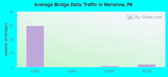
- 51,289Total average daily traffic
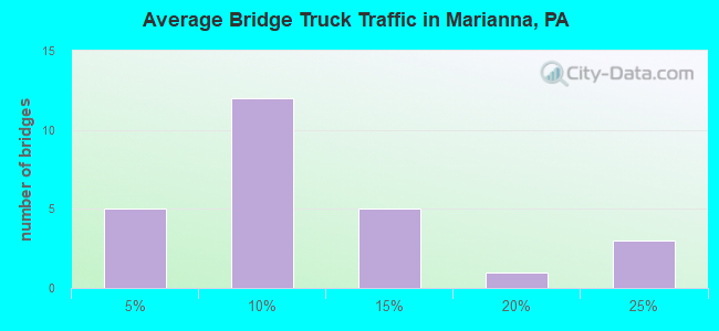
- 8,723Total average daily truck traffic
- National Bridge Inventory (NBI) Registered Bridges for Marianna
- No street view available for this location
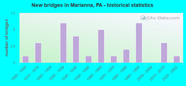
- New bridges - historical statistics
- 11900-1909
- 31910-1919
- 61930-1939
- 41940-1949
- 11950-1959
- 51960-1969
- 11970-1979
- 21980-1989
- 61990-1999
- 32010-2019
- 12020-2022
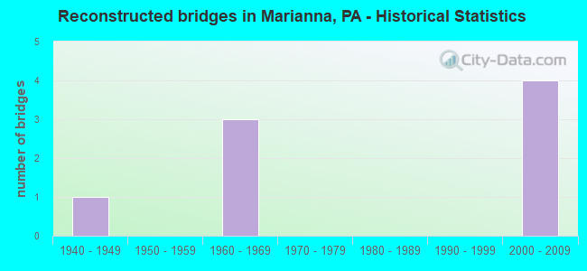
- Reconstructed bridges - Historical Statistics
- 11940-1949
- 01950-1959
- 31960-1969
- 01970-1979
- 01980-1989
- 01990-1999
- 42000-2009
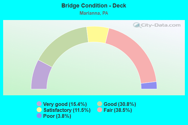
- Bridge Condition - Deck
- 15.4%Very good
- 30.8%Good
- 11.5%Satisfactory
- 38.5%Fair
- 3.8%Poor
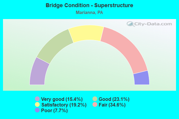
- Bridge Condition - Superstructure
- 15.4%Very good
- 23.1%Good
- 19.2%Satisfactory
- 34.6%Fair
- 7.7%Poor
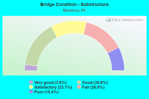
- Bridge Condition - Substructure
- 3.8%Very good
- 30.8%Good
- 23.1%Satisfactory
- 26.9%Fair
- 15.4%Poor
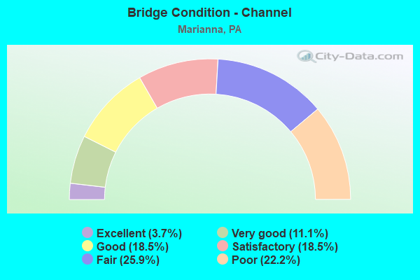
- Bridge Condition - Channel
- 3.7%Excellent
- 11.1%Very good
- 18.5%Good
- 18.5%Satisfactory
- 25.9%Fair
- 22.2%Poor
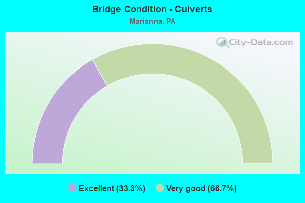
- Bridge Condition - Culverts
- 33.3%Excellent
- 66.7%Very good
Find on map >> Show street view
Structure Number: 1807, Location: WASHINGTON TOWNSHIP (Lat: 39.971622, Lng: -80.176997), Route carried "on" structure: US 19, Year Built: 1993, Status: Open, Structure Length: 0.76m (2.49ft), Average Daily Traffic: 666 (year 2021), Truck Traffic: 15%, Average Future Daily Traffic: 769 (year 2032), Design Load: HS 25 or greater, Features Intersected: BOYD RUN
Minimum Vertical Clearance: 30+ m (98+ ft), Kilometerpoint: 36.883, Lanes on structure: 2, Owner: State Highway Agency, Approaching Roadway Width: 7.3m (24.0ft), Skew: 2 degrees, Material/Design: Concrete, Design/Construction: Slab, Number Of Spans In Main Unit: 1, Length of Maximum Span: 7.3m (24.0ft), Curb or Sidewalk Widths: Left: 0.2m (0.7ft), Right: 0.2m (0.7ft), Curb-To-Curb Width: 9.8m (32.2ft), Out-to-Out Width: 10.8m (35.4ft)
Condition: Deck: Good, Superstructure: Good, Substructure: Good, Channel: Fair, Operating Rating: 79.8 metric tons, Method Used To Determine Operating Rating: Load Factor (LF), Inventory Rating: 47.2 metric tons, Method Used To Determine Inventory Rating: Load Factor (LF), Structural Evaluation: Better than present minimum criteria, Deck Geometry: Equal to present minimum criteria, Waterway Adequacy: Equal to present minimum criteria, Approach Roadway Alignment: Equal to present desirable criteria, Length Of Structure Improvement: 1.50m (4.92ft), Designated Inspection Frequency: Every 48 months, Inspection Date: August 2020, Wearing Surface/Protective System: Wearing Surface: Monolithic Concrete, Deck Protection: Epoxy Coated Reinforcing
Find on map >> Show street view
Structure Number: 18122, Location: WASHINGTON TOWNSHIP (Lat: 39.978658, Lng: -80.179311), Route carried "on" structure: Interstate 79, Year Built: 1966, Year Reconstructed: 2012, Status: Open, Structure Length: 3.51m (11.52ft), Average Daily Traffic: 12,139 (year 2021), Truck Traffic: 21%, Average Future Daily Traffic: 7,563 (year 2032), Design Load: HS 25 or greater, Features Intersected: TOWNSHIP ROAD 552
Minimum Vertical Clearance: 30+ m (98+ ft), Kilometerpoint: 32.217, Lanes on structure: 2, Lanes under structure: 2, Base Highway Network: Yes, Owner: State Highway Agency, Approaching Roadway Width: 12.8m (42.0ft), Skew: 10 degrees, Material/Design: Prestressed concrete, Design/Construction: Box Beam or Girders - Single/Spread, Number Of Spans In Main Unit: 3, Length of Maximum Span: 12.5m (41.0ft), Curb or Sidewalk Widths: Left: 0.2m (0.7ft), Right: 0.2m (0.7ft), Curb-To-Curb Width: 11.7m (38.4ft), Out-to-Out Width: 13.0m (42.7ft)
Condition: Deck: Very good, Superstructure: Fair, Substructure: Satisfactory, Operating Rating: 58.1 metric tons, Method Used To Determine Operating Rating: Load Factor (LF), Inventory Rating: 34.5 metric tons, Method Used To Determine Inventory Rating: Load Factor (LF), Structural Evaluation: Somewhat better than minimum adequacy, Deck Geometry: Equal to present minimum criteria, Underclear: Better than present minimum criteria, Approach Roadway Alignment: Equal to present desirable criteria, Length Of Structure Improvement: 4.40m (14.44ft), Designated Inspection Frequency: Every 24 months, Inspection Date: August 2020, Bridge Improvement Cost: $62,000, Roadway Improvement Cost: $182,000, Total Project Cost: $835,000, Deck Structure Type: Concrete Cast-file-Place, Wearing Surface/Protective System: Wearing Surface: Monolithic Concrete, Deck Protection: Epoxy Coated Reinforcing
Find on map >> Show street view
Structure Number: 18218, Location: MORGAN TOWNSHIP (Lat: 39.971261, Lng: -80.095628), Route carried "on" structure: State highway , Year Built: 1930, Status: Open, Structure Length: 0.73m (2.40ft), Average Daily Traffic: 47 (year 2018), Truck Traffic: 6%, Average Future Daily Traffic: 114 (year 2032), Design Load: H 20, Features Intersected: BRANCH OF CASTILE RUN, Facility Carried by Structure: SR 1014
Minimum Vertical Clearance: 30+ m (98+ ft), Kilometerpoint: 3.558, Lanes on structure: 2, Owner: State Highway Agency, Approaching Roadway Width: 4.9m (16.1ft), Material/Design: Concrete, Design/Construction: Tee Beam, Number Of Spans In Main Unit: 1, Length of Maximum Span: 6.7m (22.0ft), Curb or Sidewalk Widths: Left: 0.2m (0.7ft), Right: 0.2m (0.7ft), Curb-To-Curb Width: 6.5m (21.3ft), Out-to-Out Width: 7.6m (24.9ft)
Condition: Deck: Good, Superstructure: Fair, Substructure: Poor, Channel: Poor, Operating Rating: 58.1 metric tons, Method Used To Determine Operating Rating: Load Factor (LF), Inventory Rating: 34.5 metric tons, Method Used To Determine Inventory Rating: Load Factor (LF), Structural Evaluation: Meets minimum limits, Deck Geometry: Somewhat better than minimum adequacy, Waterway Adequacy: Better than present minimum criteria, Approach Roadway Alignment: Better than present minimum criteria, Length Of Structure Improvement: 1.40m (4.59ft), Designated Inspection Frequency: Every 24 months, Inspection Date: September 2020, Deck Structure Type: Concrete Cast-file-Place, Wearing Surface/Protective System: Wearing Surface: Bituminous
Find on map >> Show street view
Structure Number: 34535, Location: AMWELL TOWNSHIP (Lat: 40.017819, Lng: -80.175478), Route carried "on" structure: Interstate 79, Year Built: 1998, Status: Open, Structure Length: 7.19m (23.59ft), Average Daily Traffic: 12,139 (year 2021), Truck Traffic: 21%, Average Future Daily Traffic: 7,448 (year 2032), Design Load: HS 25 or greater, Features Intersected: SR 2020 & TENMILE CREEK
Minimum Vertical Clearance: 30+ m (98+ ft), Kilometerpoint: 1.823, Lanes on structure: 3, Lanes under structure: 2, Base Highway Network: Yes, Owner: State Highway Agency, Approaching Roadway Width: 18.3m (60.0ft), Skew: 10 degrees, Material/Design: Prestressed concrete, Design/Construction: Box Beam or Girders - Single/Spread, Number Of Spans In Main Unit: 3, Length of Maximum Span: 25.9m (85.0ft), Curb or Sidewalk Widths: Left: 0.2m (0.7ft), Right: 0.2m (0.7ft), Curb-To-Curb Width: 18.3m (60.0ft), Out-to-Out Width: 19.1m (62.7ft)
Condition: Deck: Good, Superstructure: Satisfactory, Substructure: Good, Channel: Good, Operating Rating: 89.8 metric tons, Method Used To Determine Operating Rating: Load Factor (LF), Inventory Rating: 48.1 metric tons, Method Used To Determine Inventory Rating: Load Factor (LF), Structural Evaluation: Equal to present minimum criteria, Deck Geometry: Better than present minimum criteria, Underclear: Better than present minimum criteria, Waterway Adequacy: Superior to present desirable criteria, Approach Roadway Alignment: Equal to present desirable criteria, Length Of Structure Improvement: 8.10m (26.57ft), Designated Inspection Frequency: Every 24 months, Inspection Date: September 2021, Bridge Improvement Cost: $57,000, Roadway Improvement Cost: $200,000, Total Project Cost: $771,000, Deck Structure Type: Corrugated Steel, Wearing Surface/Protective System: Wearing Surface: Monolithic Concrete, Deck Protection: Epoxy Coated Reinforcing
Find on map >> Show street view
Structure Number: 34536, Location: AMWELL TOWNSHIP (Lat: 40.017869, Lng: -80.175822), Route carried "on" structure: Interstate 79, Year Built: 1998, Status: Open, Structure Length: 7.10m (23.29ft), Average Daily Traffic: 11,726 (year 2021), Truck Traffic: 20%, Average Future Daily Traffic: 7,193 (year 2032), Design Load: HS 20, Features Intersected: SR 2020 & TENMILE CREEK
Minimum Vertical Clearance: 30.45m (99.90ft), Kilometerpoint: 1.836, Lanes on structure: 3, Lanes under structure: 2, Base Highway Network: Yes, Owner: State Highway Agency, Approaching Roadway Width: 17.7m (58.1ft), Skew: 10 degrees, Material/Design: Prestressed concrete, Design/Construction: Box Beam or Girders - Single/Spread, Number Of Spans In Main Unit: 3, Length of Maximum Span: 29.9m (98.1ft), Curb-To-Curb Width: 16.8m (55.1ft), Out-to-Out Width: 17.6m (57.7ft)
Condition: Deck: Good, Superstructure: Good, Substructure: Satisfactory, Channel: Very good, Inventory Rating: 49.0 metric tons, Method Used To Determine Inventory Rating: Load Factor (LF), Structural Evaluation: Equal to present minimum criteria, Deck Geometry: Equal to present minimum criteria, Underclear: Superior to present desirable criteria, Waterway Adequacy: Superior to present desirable criteria, Approach Roadway Alignment: Equal to present desirable criteria, Length Of Structure Improvement: 8.10m (26.57ft), Designated Inspection Frequency: Every 24 months, Inspection Date: September 2021, Bridge Improvement Cost: $73,000, Roadway Improvement Cost: $214,000, Total Project Cost: $982,000, Deck Structure Type: Concrete Cast-file-Place, Wearing Surface/Protective System: Wearing Surface: Monolithic Concrete, Deck Protection: Epoxy Coated Reinforcing
Find on map >> Show street view
Structure Number: 34894, Location: WEST BETHLEHEM TOWNSHIP (Lat: 40.031006, Lng: -80.091986), Route carried "on" structure: State highway , Year Built: 1986, Status: Open, Structure Length: 2.04m (6.69ft), Average Daily Traffic: 1,181 (year 2021), Truck Traffic: 7%, Average Future Daily Traffic: 1,490 (year 2032), Design Load: HS 25 or greater, Features Intersected: DANIELS RUN, Facility Carried by Structure: SR 2011
Minimum Vertical Clearance: 30+ m (98+ ft), Kilometerpoint: 11.325, Lanes on structure: 2, Owner: State Highway Agency, Approaching Roadway Width: 10.4m (34.1ft), Skew: 2 degrees, Material/Design: Prestressed concrete, Design/Construction: Box Beam or Girders - Multiple, Number Of Spans In Main Unit: 1, Length of Maximum Span: 20.1m (65.9ft), Curb or Sidewalk Widths: Left: 0.2m (0.7ft), Right: 0.2m (0.7ft), Curb-To-Curb Width: 11.2m (36.7ft), Out-to-Out Width: 12.3m (40.4ft)
Condition: Deck: Good, Superstructure: Good, Substructure: Good, Channel: Good, Inventory Rating: 93.4 metric tons, Method Used To Determine Inventory Rating: Load Factor (LF), Structural Evaluation: Better than present minimum criteria, Deck Geometry: Equal to present minimum criteria, Waterway Adequacy: Superior to present desirable criteria, Approach Roadway Alignment: Equal to present desirable criteria, Length Of Structure Improvement: 2.70m (8.86ft), Designated Inspection Frequency: Every 48 months, Inspection Date: April 2018, Deck Structure Type: Concrete Cast-file-Place, Wearing Surface/Protective System: Wearing Surface: Bituminous, Deck Protection: Epoxy Coated Reinforcing
Find on map >> Show street view
Structure Number: 34895, Location: WEST BETHLEHEM TOWNSHIP (Lat: 40.063858, Lng: -80.120539), Route carried "on" structure: State highway , Year Built: 1910, Status: Open, Structure Length: 0.73m (2.40ft), Average Daily Traffic: 1,550 (year 2021), Truck Traffic: 10%, Average Future Daily Traffic: 1,464 (year 2032), Design Load: H 10, Features Intersected: LITTLE DANIELS RUN, Facility Carried by Structure: SR 2011
Minimum Vertical Clearance: 30+ m (98+ ft), Kilometerpoint: 15.342, Lanes on structure: 2, Owner: State Highway Agency, Approaching Roadway Width: 7.0m (23.0ft), Skew: 4 degrees, Material/Design: Concrete continuous, Design/Construction: Stringer/Multi-beam, Number Of Spans In Main Unit: 1, Length of Maximum Span: 6.7m (22.0ft), Curb-To-Curb Width: 7.0m (23.0ft), Out-to-Out Width: 8.0m (26.2ft)
Condition: Deck: Fair, Superstructure: Fair, Substructure: Fair, Channel: Fair, Operating Rating: 63.5 metric tons, Method Used To Determine Operating Rating: Load Factor (LF), Inventory Rating: 38.1 metric tons, Method Used To Determine Inventory Rating: Load Factor (LF), Structural Evaluation: Somewhat better than minimum adequacy, Deck Geometry: High priority of corrective action, Waterway Adequacy: Superior to present desirable criteria, Approach Roadway Alignment: Better than present minimum criteria, Length Of Structure Improvement: 1.40m (4.59ft), Designated Inspection Frequency: Every 24 months, Inspection Date: April 2020, Bridge Improvement Cost: $5,000, Roadway Improvement Cost: $15,000, Total Project Cost: $70,000, Deck Structure Type: Concrete Cast-file-Place, Wearing Surface/Protective System: Wearing Surface: Bituminous
Find on map >> Show street view
Structure Number: 34897, Location: WEST BETHLEHEM TOWNSHIP (Lat: 40.061103, Lng: -80.149881), Route carried "on" structure: State highway , Year Built: 1930, Status: Open, Structure Length: 0.70m (2.30ft), Average Daily Traffic: 1,550 (year 2021), Truck Traffic: 10%, Average Future Daily Traffic: 1,464 (year 2032), Design Load: H 20, Features Intersected: HAINERS RUN, Facility Carried by Structure: SR 2011
Minimum Vertical Clearance: 30+ m (98+ ft), Kilometerpoint: 18.631, Lanes on structure: 2, Owner: State Highway Agency, Approaching Roadway Width: 6.7m (22.0ft), Material/Design: Steel, Design/Construction: Stringer/Multi-beam, Number Of Spans In Main Unit: 1, Length of Maximum Span: 7.0m (23.0ft), Curb-To-Curb Width: 7.0m (23.0ft), Out-to-Out Width: 7.9m (25.9ft)
Condition: Deck: Fair, Superstructure: Fair, Substructure: Fair, Channel: Satisfactory, Operating Rating: 55.3 metric tons, Method Used To Determine Operating Rating: Load Factor (LF), Inventory Rating: 33.6 metric tons, Method Used To Determine Inventory Rating: Load Factor (LF), Structural Evaluation: Somewhat better than minimum adequacy, Deck Geometry: High priority of corrective action, Waterway Adequacy: Equal to present desirable criteria, Approach Roadway Alignment: Better than present minimum criteria, Length Of Structure Improvement: 0.60m (1.97ft), Designated Inspection Frequency: Every 24 months, Inspection Date: April 2020, Bridge Improvement Cost: $18,000, Roadway Improvement Cost: $150,000, Total Project Cost: $244,000, Deck Structure Type: Concrete Cast-file-Place, Wearing Surface/Protective System: Wearing Surface: Bituminous
Find on map >> Show street view
Structure Number: 34908, Location: WEST BETHLEHEM TOWNSHIP (Lat: 40.044808, Lng: -80.089786), Route carried "on" structure: State highway , Year Built: 1962, Status: Open, Structure Length: 0.73m (2.40ft), Average Daily Traffic: 170 (year 2022), Truck Traffic: 5%, Average Future Daily Traffic: 875 (year 2032), Design Load: HS 20, Features Intersected: BRANCH OF DANIELS RUN, Facility Carried by Structure: SR 2015
Minimum Vertical Clearance: 30+ m (98+ ft), Kilometerpoint: 1.114, Lanes on structure: 2, Owner: State Highway Agency, Approaching Roadway Width: 9.4m (30.8ft), Skew: 1 degrees, Material/Design: Concrete, Design/Construction: Slab, Number Of Spans In Main Unit: 1, Length of Maximum Span: 6.7m (22.0ft), Curb or Sidewalk Widths: Left: 0.5m (1.6ft), Right: 0.5m (1.6ft), Curb-To-Curb Width: 9.1m (29.9ft), Out-to-Out Width: 10.8m (35.4ft)
Condition: Deck: Good, Superstructure: Good, Substructure: Satisfactory, Channel: Fair, Operating Rating: 51.7 metric tons, Method Used To Determine Operating Rating: Load Factor (LF), Inventory Rating: 30.8 metric tons, Method Used To Determine Inventory Rating: Load Factor (LF), Structural Evaluation: Equal to present minimum criteria, Deck Geometry: Equal to present minimum criteria, Waterway Adequacy: Superior to present desirable criteria, Approach Roadway Alignment: Equal to present desirable criteria, Length Of Structure Improvement: 1.40m (4.59ft), Designated Inspection Frequency: Every 24 months, Inspection Date: April 2020, Bridge Improvement Cost: $6,000, Roadway Improvement Cost: $18,000, Total Project Cost: $82,000, Wearing Surface/Protective System: Wearing Surface: Bituminous
Find on map >> Show street view
Structure Number: 34927, Location: AMWELL TOWNSHIP (Lat: 40.016900, Lng: -80.171036), Route carried "on" structure: State highway , Year Built: 1938, Year Reconstructed: 1972, Status: Posted for load, Structure Length: 2.99m (9.81ft), Average Daily Traffic: 561 (year 2022), Truck Traffic: 9%, Average Future Daily Traffic: 796 (year 2032), Design Load: H 20, Features Intersected: MONTGOMERY RUN, Facility Carried by Structure: SR 2020
Minimum Vertical Clearance: 30+ m (98+ ft), Kilometerpoint: 7.717, Lanes on structure: 2, Owner: State Highway Agency, Approaching Roadway Width: 4.9m (16.1ft), Skew: 1 degrees, Material/Design: Steel, Design/Construction: Stringer/Multi-beam, Number Of Spans In Main Unit: 2, Length of Maximum Span: 14.6m (47.9ft), Curb or Sidewalk Widths: Left: 0.2m (0.7ft), Right: 0.2m (0.7ft), Curb-To-Curb Width: 6.7m (22.0ft), Out-to-Out Width: 7.3m (24.0ft)
Condition: Deck: Fair, Superstructure: Fair, Substructure: Fair, Channel: Fair, Operating Rating: 37.2 metric tons, Method Used To Determine Operating Rating: Load Factor (LF), Inventory Rating: 21.8 metric tons, Method Used To Determine Inventory Rating: Load Factor (LF), Structural Evaluation: Somewhat better than minimum adequacy, Deck Geometry: Meets minimum limits, Waterway Adequacy: Equal to present desirable criteria, Approach Roadway Alignment: Equal to present desirable criteria, Bridge Posting: Required (Relationship of Operating Rating to Maximum Legal Load: 0.1 - 9.9% below), Length Of Structure Improvement: 3.00m (9.84ft), Designated Inspection Frequency: Every 24 months, Other Special Inspection Frequency: Every 12 months, Inspection Date: April 2020, Other Special Inspection Date: March 2021, Bridge Improvement Cost: $66,000, Roadway Improvement Cost: $200,000, Total Project Cost: $896,000, Deck Structure Type: Open Grating
Find on map >> Show street view
Structure Number: 34928, Location: AMWELL TOWNSHIP (Lat: 40.021617, Lng: -80.160694), Route carried "on" structure: State highway , Year Built: 1938, Year Reconstructed: 1972, Status: Open, Structure Length: 2.32m (7.61ft), Average Daily Traffic: 561 (year 2022), Truck Traffic: 9%, Average Future Daily Traffic: 796 (year 2032), Design Load: H 15, Features Intersected: NORTH FORK TENMILE CREEK, Facility Carried by Structure: SR 2020
Minimum Vertical Clearance: 30+ m (98+ ft), Kilometerpoint: 9.389, Lanes on structure: 2, Owner: State Highway Agency, Approaching Roadway Width: 6.1m (20.0ft), Material/Design: Steel, Design/Construction: Stringer/Multi-beam, Number Of Spans In Main Unit: 1, Length of Maximum Span: 22.6m (74.1ft), Curb or Sidewalk Widths: Left: 0.2m (0.7ft), Right: 0.2m (0.7ft), Curb-To-Curb Width: 6.7m (22.0ft), Out-to-Out Width: 7.3m (24.0ft)
Condition: Deck: Fair, Superstructure: Fair, Substructure: Satisfactory, Channel: Satisfactory, Operating Rating: 63.5 metric tons, Method Used To Determine Operating Rating: Load Factor (LF), Inventory Rating: 38.1 metric tons, Method Used To Determine Inventory Rating: Load Factor (LF), Structural Evaluation: Somewhat better than minimum adequacy, Deck Geometry: Meets minimum limits, Waterway Adequacy: Superior to present desirable criteria, Approach Roadway Alignment: Equal to present desirable criteria, Length Of Structure Improvement: 2.30m (7.55ft), Designated Inspection Frequency: Every 24 months, Inspection Date: April 2020, Bridge Improvement Cost: $22,000, Roadway Improvement Cost: $200,000, Total Project Cost: $297,000, Deck Structure Type: Open Grating
Find on map >> Show street view
Structure Number: 34929, Location: AMWELL TOWNSHIP (Lat: 40.020831, Lng: -80.157553), Route carried "on" structure: State highway , Year Built: 1938, Year Reconstructed: 1972, Status: Open, Structure Length: 3.54m (11.61ft), Average Daily Traffic: 561 (year 2022), Truck Traffic: 9%, Average Future Daily Traffic: 796 (year 2035), Design Load: H 15, Features Intersected: NORTH FORK TENMILE CREEK, Facility Carried by Structure: SR 2020
Minimum Vertical Clearance: 30+ m (98+ ft), Kilometerpoint: 9.389, Lanes on structure: 2, Owner: State Highway Agency, Approaching Roadway Width: 5.5m (18.0ft), Skew: 1 degrees, Material/Design: Steel, Design/Construction: Stringer/Multi-beam, Number Of Spans In Main Unit: 2, Length of Maximum Span: 17.1m (56.1ft), Curb or Sidewalk Widths: Left: 0.2m (0.7ft), Right: 0.2m (0.7ft), Curb-To-Curb Width: 6.7m (22.0ft), Out-to-Out Width: 7.3m (24.0ft)
Condition: Deck: Fair, Superstructure: Satisfactory, Substructure: Satisfactory, Channel: Fair, Operating Rating: 41.7 metric tons, Method Used To Determine Operating Rating: Load Factor (LF), Inventory Rating: 25.4 metric tons, Method Used To Determine Inventory Rating: Load Factor (LF), Structural Evaluation: Equal to present minimum criteria, Deck Geometry: Meets minimum limits, Waterway Adequacy: Equal to present minimum criteria, Approach Roadway Alignment: Better than present minimum criteria, Length Of Structure Improvement: 3.90m (12.80ft), Designated Inspection Frequency: Every 24 months, Inspection Date: April 2020, Bridge Improvement Cost: $30,000, Roadway Improvement Cost: $200,000, Total Project Cost: $399,000, Deck Structure Type: Open Grating
Find on map >> Show street view
Structure Number: 34931, Location: MARIANNA BOROUGH (Lat: 40.018294, Lng: -80.108047), Route carried "on" structure: State highway , Year Built: 1934, Status: Open, Structure Length: 0.85m (2.79ft), Average Daily Traffic: 1,130 (year 2021), Truck Traffic: 12%, Average Future Daily Traffic: 413 (year 2032), Design Load: H 15, Features Intersected: HORN RUN, Facility Carried by Structure: SR 2020
Minimum Vertical Clearance: 30+ m (98+ ft), Kilometerpoint: 15.889, Lanes on structure: 2, Owner: State Highway Agency, Approaching Roadway Width: 7.0m (23.0ft), Skew: 1 degrees, Material/Design: Concrete continuous, Design/Construction: Stringer/Multi-beam, Number Of Spans In Main Unit: 1, Length of Maximum Span: 6.7m (22.0ft), Curb-To-Curb Width: 7.0m (23.0ft), Out-to-Out Width: 7.9m (25.9ft)
Condition: Deck: Good, Superstructure: Satisfactory, Substructure: Good, Channel: Poor, Operating Rating: 89.8 metric tons, Method Used To Determine Operating Rating: Load Factor (LF), Inventory Rating: 67.1 metric tons, Method Used To Determine Inventory Rating: Load Factor (LF), Structural Evaluation: Equal to present minimum criteria, Deck Geometry: High priority of corrective action, Waterway Adequacy: Better than present minimum criteria, Approach Roadway Alignment: Equal to present desirable criteria, Length Of Structure Improvement: 1.50m (4.92ft), Designated Inspection Frequency: Every 48 months, Inspection Date: April 2020, Bridge Improvement Cost: $6,000, Roadway Improvement Cost: $16,000, Total Project Cost: $75,000, Wearing Surface/Protective System: Wearing Surface: Bituminous
Find on map >> Show street view
Structure Number: 34932, Location: W. BETHLEHEM & MARIANNA B (Lat: 40.018650, Lng: -80.106506), Route carried "on" structure: State highway , Year Built: 1942, Year Reconstructed: 2007, Status: Open, Structure Length: 3.17m (10.40ft), Average Daily Traffic: 1,130 (year 2021), Truck Traffic: 12%, Average Future Daily Traffic: 413 (year 2032), Design Load: HL 93, Features Intersected: LITTLE TENMILE CREEK, Facility Carried by Structure: SR 2020
Minimum Vertical Clearance: 30+ m (98+ ft), Kilometerpoint: 16.694, Lanes on structure: 2, Owner: State Highway Agency, Approaching Roadway Width: 6.7m (22.0ft), Material/Design: Steel, Design/Construction: Stringer/Multi-beam, Number Of Spans In Main Unit: 2, Length of Maximum Span: 15.2m (49.9ft), Curb-To-Curb Width: 7.3m (24.0ft), Out-to-Out Width: 8.4m (27.6ft)
Condition: Deck: Very good, Superstructure: Very good, Substructure: Good, Channel: Fair, Inventory Rating: 51.7 metric tons, Method Used To Determine Inventory Rating: Load and Resistance Factor (LRFR), Structural Evaluation: Better than present minimum criteria, Deck Geometry: Meets minimum limits, Waterway Adequacy: Equal to present desirable criteria, Approach Roadway Alignment: Better than present minimum criteria, Length Of Structure Improvement: 3.00m (9.84ft), Designated Inspection Frequency: Every 48 months, Inspection Date: April 2020, Bridge Improvement Cost: $19,000, Roadway Improvement Cost: $55,000, Total Project Cost: $254,000, Deck Structure Type: Concrete Cast-file-Place, Wearing Surface/Protective System: Wearing Surface: Monolithic Concrete, Deck Protection: Epoxy Coated Reinforcing
Find on map >> Show street view
Structure Number: 34934, Location: WEST BETHLEHEM TOWNSHIP (Lat: 40.024342, Lng: -80.088283), Route carried "on" structure: State highway , Year Built: 1968, Status: Open, Structure Length: 3.32m (10.89ft), Average Daily Traffic: 1,130 (year 2021), Truck Traffic: 12%, Average Future Daily Traffic: 413 (year 2032), Design Load: HS 20+Mod, Features Intersected: LITTLE TENMILE CREEK, Facility Carried by Structure: SR 2020
Minimum Vertical Clearance: 30+ m (98+ ft), Kilometerpoint: 18.044, Lanes on structure: 2, Owner: State Highway Agency, Approaching Roadway Width: 8.5m (27.9ft), Skew: 1 degrees, Material/Design: Prestressed concrete, Design/Construction: Box Beam or Girders - Single/Spread, Number Of Spans In Main Unit: 2, Length of Maximum Span: 16.2m (53.1ft), Curb or Sidewalk Widths: Left: 1.5m (4.9ft), Right: 0.5m (1.6ft), Curb-To-Curb Width: 10.4m (34.1ft), Out-to-Out Width: 13.1m (43.0ft)
Condition: Deck: Fair, Superstructure: Satisfactory, Substructure: Good, Channel: Satisfactory, Operating Rating: 61.7 metric tons, Method Used To Determine Operating Rating: Load Factor (LF), Inventory Rating: 36.3 metric tons, Method Used To Determine Inventory Rating: Load Factor (LF), Structural Evaluation: Equal to present minimum criteria, Deck Geometry: Equal to present minimum criteria, Waterway Adequacy: Superior to present desirable criteria, Approach Roadway Alignment: Equal to present desirable criteria, Length Of Structure Improvement: 4.10m (13.45ft), Designated Inspection Frequency: Every 24 months, Inspection Date: April 2020, Bridge Improvement Cost: $35,000, Roadway Improvement Cost: $102,000, Total Project Cost: $468,000, Deck Structure Type: Concrete Cast-file-Place, Wearing Surface/Protective System: Wearing Surface: Latex Concrete
Find on map >> Show street view
Structure Number: 34941, Location: WEST BETHLEHEM TOWNSHIP (Lat: 40.005558, Lng: -80.093586), Route carried "on" structure: State highway , Year Built: 1914, Status: Posted for load, Structure Length: 1.04m (3.41ft), Average Daily Traffic: 175 (year 2022), Truck Traffic: 8%, Average Future Daily Traffic: 283 (year 2032), Design Load: H 10, Features Intersected: BARRS RUN, Facility Carried by Structure: SR 2022
Minimum Vertical Clearance: 30+ m (98+ ft), Kilometerpoint: 6.764, Lanes on structure: 1, Owner: State Highway Agency, Approaching Roadway Width: 4.3m (14.1ft), Skew: 2 degrees, Material/Design: Steel, Design/Construction: Stringer/Multi-beam, Number Of Spans In Main Unit: 1, Length of Maximum Span: 9.8m (32.2ft), Curb or Sidewalk Widths: Left: 0.3m (1.0ft), Right: 0.3m (1.0ft), Curb-To-Curb Width: 4.6m (15.1ft), Out-to-Out Width: 5.8m (19.0ft)
Condition: Deck: Satisfactory, Superstructure: Fair, Substructure: Poor, Channel: Fair, Operating Rating: 61.7 metric tons, Method Used To Determine Operating Rating: Load Factor (LF), Inventory Rating: 37.2 metric tons, Method Used To Determine Inventory Rating: Load Factor (LF), Structural Evaluation: Meets minimum limits, Deck Geometry: High priority of replacement, Waterway Adequacy: Better than present minimum criteria, Approach Roadway Alignment: Equal to present desirable criteria, Length Of Structure Improvement: 1.70m (5.58ft), Designated Inspection Frequency: Every 24 months, Other Special Inspection Frequency: Every 12 months, Inspection Date: April 2020, Other Special Inspection Date: March 2021, Bridge Improvement Cost: $11,000, Roadway Improvement Cost: $34,000, Total Project Cost: $153,000, Wearing Surface/Protective System: Wearing Surface: Bituminous
Find on map >> Show street view
Structure Number: 34942, Location: WEST BETHLEHAM TOWNSHIP (Lat: 40.006203, Lng: -80.091133), Route carried "on" structure: State highway , Year Built: 1901, Status: Posted for load, Structure Length: 1.01m (3.31ft), Average Daily Traffic: 175 (year 2022), Truck Traffic: 8%, Average Future Daily Traffic: 283 (year 2032), Design Load: H 10, Features Intersected: BARRS RUN, Facility Carried by Structure: SR 2022
Minimum Vertical Clearance: 30+ m (98+ ft), Kilometerpoint: 7.656, Lanes on structure: 1, Owner: State Highway Agency, Approaching Roadway Width: 5.2m (17.1ft), Skew: 3 degrees, Material/Design: Concrete, Design/Construction: Slab, Number Of Spans In Main Unit: 1, Length of Maximum Span: 9.1m (29.9ft), Curb-To-Curb Width: 4.7m (15.4ft), Out-to-Out Width: 5.3m (17.4ft)
Condition: Deck: Fair, Superstructure: Fair, Substructure: Poor, Channel: Satisfactory, Operating Rating: 36.3 metric tons, Method Used To Determine Operating Rating: Load Factor (LF), Inventory Rating: 21.8 metric tons, Method Used To Determine Inventory Rating: Load Factor (LF), Structural Evaluation: Meets minimum limits, Deck Geometry: High priority of replacement, Waterway Adequacy: Better than present minimum criteria, Approach Roadway Alignment: Better than present minimum criteria, Bridge Posting: Required (Relationship of Operating Rating to Maximum Legal Load: 20.0 - 29.9% below), Length Of Structure Improvement: 1.90m (6.23ft), Designated Inspection Frequency: Every 24 months, Other Special Inspection Frequency: Every 12 months, Inspection Date: April 2020, Other Special Inspection Date: March 2021, Bridge Improvement Cost: $30,000, Roadway Improvement Cost: $200,000, Total Project Cost: $400,000, Deck Structure Type: Concrete Cast-file-Place, Wearing Surface/Protective System: Wearing Surface: Bituminous
Find on map >> Show street view
Structure Number: 35006, Location: WEST BETHLEHEM TOWNSHIP (Lat: 40.033711, Lng: -80.138372), Route carried "on" structure: State highway , Year Built: 1970, Status: Open, Structure Length: 1.83m (6.00ft), Average Daily Traffic: 102 (year 2022), Truck Traffic: 1%, Average Future Daily Traffic: 136 (year 2032), Design Load: HS 20, Features Intersected: LITTLE TENMILE CREEK, Facility Carried by Structure: SR 2047
Minimum Vertical Clearance: 30+ m (98+ ft), Kilometerpoint: 2.354, Lanes on structure: 2, Owner: State Highway Agency, Approaching Roadway Width: 9.1m (29.9ft), Skew: 1 degrees, Material/Design: Prestressed concrete, Design/Construction: Box Beam or Girders - Single/Spread, Number Of Spans In Main Unit: 1, Length of Maximum Span: 17.7m (58.1ft), Curb or Sidewalk Widths: Left: 0.2m (0.7ft), Right: 0.2m (0.7ft), Curb-To-Curb Width: 11.0m (36.1ft), Out-to-Out Width: 12.2m (40.0ft)
Condition: Deck: Fair, Superstructure: Good, Substructure: Fair, Channel: Poor, Operating Rating: 70.8 metric tons, Method Used To Determine Operating Rating: Load Factor (LF), Inventory Rating: 35.4 metric tons, Method Used To Determine Inventory Rating: Load Factor (LF), Structural Evaluation: Somewhat better than minimum adequacy, Deck Geometry: Equal to present desirable criteria, Waterway Adequacy: Superior to present desirable criteria, Approach Roadway Alignment: Equal to present desirable criteria, Length Of Structure Improvement: 2.50m (8.20ft), Designated Inspection Frequency: Every 24 months, Inspection Date: May 2020, Deck Structure Type: Concrete Cast-file-Place, Wearing Surface/Protective System: Wearing Surface: Bituminous
Find on map >> Show street view
Structure Number: 35008, Location: AMWELL TOWNSHIP (Lat: 40.047864, Lng: -80.144675), Route carried "on" structure: State highway , Year Built: 1941, Year Reconstructed: 1953, Status: Posted for load, Structure Length: 1.83m (6.00ft), Average Daily Traffic: 102 (year 2022), Truck Traffic: 1%, Average Future Daily Traffic: 136 (year 2043), Design Load: H 20, Features Intersected: LITTLE TENMILE CREEK, Facility Carried by Structure: SR 2047
Minimum Vertical Clearance: 30+ m (98+ ft), Kilometerpoint: 3.837, Lanes on structure: 1, Owner: State Highway Agency, Approaching Roadway Width: 5.5m (18.0ft), Material/Design: Steel, Design/Construction: Stringer/Multi-beam, Number Of Spans In Main Unit: 1, Length of Maximum Span: 16.8m (55.1ft), Curb or Sidewalk Widths: Left: 0.1m (0.3ft), Right: 0.1m (0.3ft), Curb-To-Curb Width: 4.3m (14.1ft), Out-to-Out Width: 4.3m (14.1ft)
Condition: Deck: Poor, Superstructure: Fair, Substructure: Fair, Channel: Satisfactory, Operating Rating: 35.4 metric tons, Method Used To Determine Operating Rating: Load Factor (LF), Inventory Rating: 20.9 metric tons, Method Used To Determine Inventory Rating: Load Factor (LF), Structural Evaluation: Somewhat better than minimum adequacy, Deck Geometry: High priority of replacement, Waterway Adequacy: Superior to present desirable criteria, Approach Roadway Alignment: Meets minimum limits, Bridge Posting: Required (Relationship of Operating Rating to Maximum Legal Load: 10.0 - 19.9% below), Length Of Structure Improvement: 1.80m (5.91ft), Designated Inspection Frequency: Every 24 months, Other Special Inspection Frequency: Every 12 months, Inspection Date: May 2020, Other Special Inspection Date: April 2021, Bridge Improvement Cost: $24,000, Roadway Improvement Cost: $200,000, Total Project Cost: $322,000, Deck Structure Type: Concrete Cast-file-Place, Wearing Surface/Protective System: Wearing Surface: Monolithic Concrete
Find on map >> Show street view
Structure Number: 35011, Location: WEST BETHLEHEM TOWNSHIP (Lat: 40.005811, Lng: -80.084697), Route carried "on" structure: State highway , Year Built: 1943, Year Reconstructed: 2009, Status: Open, Structure Length: 0.94m (3.08ft), Average Daily Traffic: 1,419 (year 2021), Truck Traffic: 4%, Average Future Daily Traffic: 762 (year 2032), Design Load: HL 93, Features Intersected: BARRS RUN, Facility Carried by Structure: SR 2049
Minimum Vertical Clearance: 30+ m (98+ ft), Kilometerpoint: 0.822, Lanes on structure: 2, Owner: State Highway Agency, Approaching Roadway Width: 6.7m (22.0ft), Material/Design: Prestressed concrete, Design/Construction: Box Beam or Girders - Single/Spread, Number Of Spans In Main Unit: 1, Length of Maximum Span: 9.1m (29.9ft), Curb or Sidewalk Widths: Left: 0.1m (0.3ft), Right: 0.1m (0.3ft), Curb-To-Curb Width: 7.3m (24.0ft), Out-to-Out Width: 8.4m (27.6ft)
Condition: Deck: Good, Superstructure: Very good, Substructure: Good, Channel: Good, Operating Rating: 68.0 metric tons, Method Used To Determine Operating Rating: Load and Resistance Factor (LRFR), Inventory Rating: 52.6 metric tons, Method Used To Determine Inventory Rating: Load and Resistance Factor (LRFR), Structural Evaluation: Better than present minimum criteria, Deck Geometry: Meets minimum limits, Waterway Adequacy: Better than present minimum criteria, Approach Roadway Alignment: Equal to present desirable criteria, Length Of Structure Improvement: 1.60m (5.25ft), Designated Inspection Frequency: Every 24 months, Inspection Date: May 2020, Bridge Improvement Cost: $5,000, Roadway Improvement Cost: $15,000, Total Project Cost: $69,000, Deck Structure Type: Concrete Cast-file-Place, Wearing Surface/Protective System: Wearing Surface: Monolithic Concrete, Deck Protection: Epoxy Coated Reinforcing
Find on map >> Show street view
Structure Number: 3524, Location: 300' WEST OF SR 2020 (Lat: 40.012706, Lng: -80.131450), Route carried "on" structure: City street T318, Year Built: 1954, Status: Posted for load, Structure Length: 2.59m (8.50ft), Average Daily Traffic: 75 (year 2019), Average Future Daily Traffic: 105 (year 2039), Design Load: HS 20, Features Intersected: TENMILE CREEK, Facility Carried by Structure: SMITH BRIDGE TR318
Minimum Vertical Clearance: 30+ m (98+ ft), Kilometerpoint: 0.000, Lanes on structure: 2, Base Highway Network: Yes, Owner: County Highway Agency, Approaching Roadway Width: 3.7m (12.1ft), Material/Design: Steel, Design/Construction: Stringer/Multi-beam, Number Of Spans In Main Unit: 2, Length of Maximum Span: 12.5m (41.0ft), Curb or Sidewalk Widths: Left: 0.2m (0.7ft), Right: 0.2m (0.7ft), Curb-To-Curb Width: 5.5m (18.0ft), Out-to-Out Width: 5.8m (19.0ft)
Condition: Deck: Fair, Superstructure: Poor, Substructure: Fair, Channel: Poor, Operating Rating: 33.6 metric tons, Method Used To Determine Operating Rating: Load Factor (LF), Inventory Rating: 20.0 metric tons, Method Used To Determine Inventory Rating: Load Factor (LF), Structural Evaluation: Meets minimum limits, Deck Geometry: Meets minimum limits, Waterway Adequacy: Better than present minimum criteria, Approach Roadway Alignment: Somewhat better than minimum adequacy, Bridge Posting: Required (Relationship of Operating Rating to Maximum Legal Load: 10.0 - 19.9% below), Length Of Structure Improvement: 3.40m (11.15ft), Designated Inspection Frequency: Every 24 months, Underwater Inspection Frequency: Every 24 months, Other Special Inspection Frequency: Every 12 months, Inspection Date: August 2021, Underwater Inspection Date: May 2021, Other Special Inspection Date: August 2021, Bridge Improvement Cost: $5,000, Roadway Improvement Cost: $13,000, Total Project Cost: $62,000, Deck Structure Type: Open Grating
Find on map >> Show street view
Structure Number: 35243, Location: 150' FROM TR 735 (Lat: 40.040200, Lng: -80.178819), Route carried "on" structure: City street T688, Year Built: 1913, Year Reconstructed: 2014, Status: Open, Structure Length: 1.01m (3.31ft), Average Daily Traffic: 80 (year 2019), Average Future Daily Traffic: 210 (year 2039), Design Load: HL 93, Features Intersected: MONTGOMERY RUN, Facility Carried by Structure: T-688 Sposato Road
Minimum Vertical Clearance: 30+ m (98+ ft), Kilometerpoint: 0.000, Lanes on structure: 1, Owner: County Highway Agency, Approaching Roadway Width: 3.0m (9.8ft), Material/Design: Prestressed concrete, Design/Construction: Slab, Number Of Spans In Main Unit: 1, Length of Maximum Span: 9.4m (30.8ft), Curb-To-Curb Width: 4.4m (14.4ft), Out-to-Out Width: 5.1m (16.7ft)
Condition: Deck: Very good, Superstructure: Very good, Substructure: Good, Channel: Poor, Operating Rating: 56.1 metric tons, Method Used To Determine Operating Rating: Assigned ratings based on Load and Resistance Factor Design (LRFD) reported by rating factor (RF) using HL93 loadings, Inventory Rating: 35.3 metric tons, Method Used To Determine Inventory Rating: Assigned ratings based on Load and Resistance Factor Design (LRFD) reported by rating factor (RF) using HL93 loadings, Structural Evaluation: Better than present minimum criteria, Deck Geometry: Equal to present minimum criteria, Waterway Adequacy: Equal to present desirable criteria, Approach Roadway Alignment: Equal to present minimum criteria, Length Of Structure Improvement: 1.60m (5.25ft), Designated Inspection Frequency: Every 24 months, Inspection Date: August 2021, Bridge Improvement Cost: $5,000, Roadway Improvement Cost: $14,000, Total Project Cost: $64,000, Deck Structure Type: Concrete Cast-file-Place, Wearing Surface/Protective System: Wearing Surface: Monolithic Concrete, Deck Protection: Epoxy Coated Reinforcing
Find on map >> Show street view
Structure Number: 35244, Location: 200' FROM SR 2020 (Lat: 40.019917, Lng: -80.150911), Route carried "on" structure: County highway T733, Year Built: 1949, Status: Posted for load, Structure Length: 2.87m (9.42ft), Average Daily Traffic: 200 (year 2015), Truck Traffic: 1%, Average Future Daily Traffic: 200 (year 2035), Design Load: HS 20, Features Intersected: TENMILE CREEK, Facility Carried by Structure: IAMS HILL RD TR733
Minimum Vertical Clearance: 4.44m (14.57ft), Kilometerpoint: 0.000, Lanes on structure: 1, Base Highway Network: Yes, Owner: County Highway Agency, Approaching Roadway Width: 3.4m (11.2ft), Material/Design: Steel, Design/Construction: Truss - Thru, Number Of Spans In Main Unit: 1, Length of Maximum Span: 27.4m (89.9ft), Curb or Sidewalk Widths: Left: 0.2m (0.7ft), Right: 0.2m (0.7ft), Curb-To-Curb Width: 4.6m (15.1ft), Out-to-Out Width: 5.5m (18.0ft)
Condition: Deck: Fair, Superstructure: Poor, Substructure: Poor, Channel: Poor, Operating Rating: 23.6 metric tons, Method Used To Determine Operating Rating: Load Factor (LF), Inventory Rating: 13.6 metric tons, Method Used To Determine Inventory Rating: Load Factor (LF), Structural Evaluation: Meets minimum limits, Deck Geometry: High priority of replacement, Waterway Adequacy: Better than present minimum criteria, Approach Roadway Alignment: Somewhat better than minimum adequacy, Bridge Posting: Required (Relationship of Operating Rating to Maximum Legal Load: > 39.9% below), Length Of Structure Improvement: 3.60m (11.81ft), Designated Inspection Frequency: Every 24 months, Critical Feature Inspection Frequency: Every 12 months, Other Special Inspection Frequency: Every 12 months, Inspection Date: August 2021, Critical Feature Inspection Date: August 2021, Other Special Inspection Date: August 2021, Bridge Improvement Cost: $8,000, Roadway Improvement Cost: $24,000, Total Project Cost: $109,000, Deck Structure Type: Wood or Timber
Find on map >> Show street view
Structure Number: 35383, Location: MARIANNA BRIDGE NO.2 (Lat: 40.016467, Lng: -80.098389), Route carried "on" structure: City street , Year Built: 1989, Status: Open, Structure Length: 2.23m (7.32ft), Average Daily Traffic: 500 (year 2005), Average Future Daily Traffic: 500 (year 2015), Design Load: HS 25 or greater, Features Intersected: TEN MILE CREEK, Facility Carried by Structure: BEESON AVENUE
Minimum Vertical Clearance: 30+ m (98+ ft), Kilometerpoint: 0.000, Lanes on structure: 2, Owner: Town or Township Highway Agency, Approaching Roadway Width: 7.9m (25.9ft), Material/Design: Prestressed concrete, Design/Construction: Box Beam or Girders - Multiple, Number Of Spans In Main Unit: 1, Length of Maximum Span: 22.3m (73.2ft), Curb or Sidewalk Widths: Left: 0.2m (0.7ft), Right: 1.2m (3.9ft), Curb-To-Curb Width: 7.9m (25.9ft), Out-to-Out Width: 9.8m (32.2ft)
Condition: Deck: Satisfactory, Superstructure: Satisfactory, Substructure: Satisfactory, Channel: Good, Operating Rating: 82.6 metric tons, Method Used To Determine Operating Rating: Load Factor (LF), Inventory Rating: 41.7 metric tons, Method Used To Determine Inventory Rating: Load Factor (LF), Structural Evaluation: Equal to present minimum criteria, Deck Geometry: Somewhat better than minimum adequacy, Waterway Adequacy: Better than present minimum criteria, Approach Roadway Alignment: Equal to present desirable criteria, Length Of Structure Improvement: 3.00m (9.84ft), Designated Inspection Frequency: Every 24 months, Inspection Date: September 2021, Deck Structure Type: Concrete Cast-file-Place, Wearing Surface/Protective System: Wearing Surface: Monolithic Concrete, Deck Protection: Epoxy Coated Reinforcing
Find on map >> Show street view
Structure Number: 40542, Location: MARIANNA BRIDGE NO.1 (Lat: 40.017867, Lng: -80.098622), Route carried "on" structure: City street , Year Built: 1998, Status: Open, Structure Length: 2.90m (9.51ft), Average Daily Traffic: 500 (year 2005), Truck Traffic: 5%, Average Future Daily Traffic: 60 (year 2036), Design Load: HS 25 or greater, Features Intersected: ABANDONED RAILROAD, Facility Carried by Structure: BEESON AVENUE
Minimum Vertical Clearance: 30+ m (98+ ft), Kilometerpoint: 0.000, Lanes on structure: 2, Owner: City or Municipal Highway Agency, Approaching Roadway Width: 9.1m (29.9ft), Material/Design: Prestressed concrete, Design/Construction: Stringer/Multi-beam, Number Of Spans In Main Unit: 1, Length of Maximum Span: 28.7m (94.2ft), Curb or Sidewalk Widths: Left: 0.2m (0.7ft), Right: 1.7m (5.6ft), Curb-To-Curb Width: 9.1m (29.9ft), Out-to-Out Width: 11.7m (38.4ft)
Condition: Deck: Satisfactory, Superstructure: Good, Substructure: Fair, Operating Rating: 88.9 metric tons, Method Used To Determine Operating Rating: Load Factor (LF), Inventory Rating: 41.7 metric tons, Method Used To Determine Inventory Rating: Load Factor (LF), Structural Evaluation: Somewhat better than minimum adequacy, Deck Geometry: Equal to present minimum criteria, Approach Roadway Alignment: Equal to present desirable criteria, Designated Inspection Frequency: Every 24 months, Inspection Date: September 2021, Deck Structure Type: Concrete Cast-file-Place, Wearing Surface/Protective System: Wearing Surface: Monolithic Concrete, Deck Protection: Epoxy Coated Reinforcing
Find on map >> Show street view
Structure Number: 52607, Location: Marianna Borough (Lat: 40.010233, Lng: -80.117800), Route carried "on" structure: City street , Year Built: 2015, Status: Open, Structure Length: 0.76m (2.49ft), Average Daily Traffic: 30 (year 2014), Average Future Daily Traffic: 36 (year 2034), Design Load: HL 93, Features Intersected: Patterson Run, Facility Carried by Structure: Adamson Road
Minimum Vertical Clearance: 30+ m (98+ ft), Kilometerpoint: 0.000, Lanes on structure: 1, Owner: City or Municipal Highway Agency, Approaching Roadway Width: 5.8m (19.0ft), Skew: 2 degrees, Material/Design: Concrete, Design/Construction: Culvert, Number Of Spans In Main Unit: 1, Length of Maximum Span: 7.6m (24.9ft), Curb-To-Curb Width: 4.9m (16.1ft), Out-to-Out Width: 6.8m (22.3ft)
Condition: Channel: Good, Culverts: Very good, Operating Rating: 56.7 metric tons, Method Used To Determine Operating Rating: Assigned ratings based on Load and Resistance Factor Design (LRFD) reported by rating factor (RF) using HL93 loadings, Inventory Rating: 35.6 metric tons, Method Used To Determine Inventory Rating: Assigned ratings based on Load and Resistance Factor Design (LRFD) reported by rating factor (RF) using HL93 loadings, Structural Evaluation: Equal to present desirable criteria, Deck Geometry: High priority of corrective action, Waterway Adequacy: Superior to present desirable criteria, Approach Roadway Alignment: Equal to present desirable criteria, Designated Inspection Frequency: Every 24 months, Inspection Date: September 2021, Wearing Surface/Protective System: Wearing Surface: Monolithic Concrete, Deck Protection: Epoxy Coated Reinforcing
Find on map >> Show street view
Structure Number: 52611, Location: Washington Township (Lat: 39.973858, Lng: -80.159244), Route carried "on" structure: City street T551, Year Built: 2015, Status: Open, Structure Length: 0.67m (2.20ft), Average Daily Traffic: 20 (year 2015), Average Future Daily Traffic: 25 (year 2036), Design Load: HL 93, Features Intersected: Craynes Run, Facility Carried by Structure: T-551
Minimum Vertical Clearance: 30+ m (98+ ft), Kilometerpoint: 0.000, Lanes on structure: 1, Toll: Toll bridge, Owner: County Highway Agency, Approaching Roadway Width: 4.9m (16.1ft), Material/Design: Concrete, Design/Construction: Culvert, Number Of Spans In Main Unit: 1, Length of Maximum Span: 6.7m (22.0ft), Curb-To-Curb Width: 4.9m (16.1ft), Out-to-Out Width: 6.1m (20.0ft)
Condition: Channel: Very good, Culverts: Very good, Operating Rating: 58.3 metric tons, Method Used To Determine Operating Rating: Assigned ratings based on Load and Resistance Factor Design (LRFD) reported by rating factor (RF) using HL93 loadings, Inventory Rating: 36.6 metric tons, Method Used To Determine Inventory Rating: Assigned ratings based on Load and Resistance Factor Design (LRFD) reported by rating factor (RF) using HL93 loadings, Structural Evaluation: Equal to present desirable criteria, Deck Geometry: High priority of corrective action, Waterway Adequacy: Equal to present desirable criteria, Approach Roadway Alignment: Equal to present desirable criteria, Designated Inspection Frequency: Every 24 months, Inspection Date: October 2020
Find on map >> Show street view
Structure Number: 5359, Location: WEST BETHLEHEM TOWNSHIP (Lat: 40.042764, Lng: -80.090881), Route carried "on" structure: State highway , Year Built: 2016, Status: Open, Structure Length: 1.95m (6.40ft), Average Daily Traffic: 170 (year 2022), Truck Traffic: 5%, Average Future Daily Traffic: 810 (year 2037), Design Load: HL 93, Features Intersected: DANIELS RUN, Facility Carried by Structure: SPRING VALLEY RD
Minimum Vertical Clearance: 30+ m (98+ ft), Kilometerpoint: 1.114, Lanes on structure: 2, Owner: State Highway Agency, Maintenance Responsibility: Private, Approaching Roadway Width: 6.1m (20.0ft), Material/Design: Prestressed concrete, Design/Construction: Box Beam or Girders - Single/Spread, Number Of Spans In Main Unit: 1, Length of Maximum Span: 18.3m (60.0ft), Curb-To-Curb Width: 8.5m (27.9ft), Out-to-Out Width: 9.1m (29.9ft)
Condition: Deck: Very good, Superstructure: Very good, Substructure: Very good, Channel: Very good, Operating Rating: 55.4 metric tons, Method Used To Determine Operating Rating: Assigned ratings based on Load and Resistance Factor Design (LRFD) reported by rating factor (RF) using HL93 loadings, Inventory Rating: 42.8 metric tons, Method Used To Determine Inventory Rating: Assigned ratings based on Load and Resistance Factor Design (LRFD) reported by rating factor (RF) using HL93 loadings, Structural Evaluation: Equal to present desirable criteria, Deck Geometry: Equal to present minimum criteria, Waterway Adequacy: Superior to present desirable criteria, Approach Roadway Alignment: Meets minimum limits, Designated Inspection Frequency: Every 24 months, Inspection Date: May 2020, Deck Structure Type: Concrete Cast-file-Place, Wearing Surface/Protective System: Wearing Surface: Integral Concrete, Deck Protection: Epoxy Coated Reinforcing
Find on map >> Show street view
Structure Number: 68308, Location: WEST BETHLEHEM TOWNSHIP (Lat: 40.045389, Lng: -80.086181), Route carried "on" structure: State highway , Year Built: 2021, Status: Open, Structure Length: 0.79m (2.59ft), Average Daily Traffic: 78 (year 2022), Truck Traffic: 4%, Average Future Daily Traffic: 101 (year 2032), Design Load: HL 93, Features Intersected: Branch of Daniels Run, Facility Carried by Structure: SR 2053
Minimum Vertical Clearance: 30+ m (98+ ft), Kilometerpoint: 0.000, Lanes on structure: 2, Owner: State Highway Agency, Approaching Roadway Width: 5.5m (18.0ft), Skew: 3 degrees, Material/Design: Concrete, Design/Construction: Culvert, Number Of Spans In Main Unit: 1, Length of Maximum Span: 7.0m (23.0ft), Curb-To-Curb Width: 6.7m (22.0ft), Out-to-Out Width: 9.0m (29.5ft)
Condition: Channel: Excellent, Culverts: Excellent, Operating Rating: 45.4 metric tons, Method Used To Determine Operating Rating: Assigned ratings based on Load and Resistance Factor Design (LRFD) reported by rating factor (RF) using HL93 loadings, Inventory Rating: 35.0 metric tons, Method Used To Determine Inventory Rating: Assigned ratings based on Load and Resistance Factor Design (LRFD) reported by rating factor (RF) using HL93 loadings, Structural Evaluation: Superior to present desirable criteria, Deck Geometry: Somewhat better than minimum adequacy, Waterway Adequacy: Superior to present desirable criteria, Approach Roadway Alignment: Equal to present desirable criteria, Designated Inspection Frequency: Every 24 months, Inspection Date: September 2021
Find on map >> Show street view
Structure Number: 18122, Location: WASHINGTON TOWNSHIP (Lat: 39.978658, Lng: -80.179311), Route carried "under" structure: City street T552, Year Built: 1966, Structure Length: 0. m, Average Daily Traffic: 150 (year 1991), Features Intersected: TOWNSHIP ROAD 552, Facility Carried by Structure: SR 0079
Minimum Vertical Clearance: 4.80m (15.75ft), Kilometerpoint: 0.000, Lanes on structure: 2, Lanes under structure: 2, Material/Design: Prestressed concrete, Design/Construction: Box Beam or Girders - Single/Spread, Length of Maximum Span: 12.5m (41.0ft)
Find on map >> Show street view
Structure Number: 18123, Location: WASHINGTON TOWNSHIP (Lat: 39.978506, Lng: -80.179569), Route carried "under" structure: City street T552, Year Built: 1966, Structure Length: 0. m, Average Daily Traffic: 150 (year 1991), Features Intersected: TOWNSHIP ROAD 552, Facility Carried by Structure: SR 0079
Minimum Vertical Clearance: 4.60m (15.09ft), Kilometerpoint: 0.000, Lanes on structure: 2, Lanes under structure: 2, Material/Design: Prestressed concrete, Design/Construction: Box Beam or Girders - Single/Spread, Length of Maximum Span: 12.5m (41.0ft)
Find on map >> Show street view
Structure Number: 34535, Location: AMWELL TOWNSHIP (Lat: 40.017819, Lng: -80.175478), Route carried "under" structure: State highway , Year Built: 1998, Structure Length: 0. m, Average Daily Traffic: 561 (year 2022), Truck Traffic: 9%, Features Intersected: SR 2020 & TENMILE CREEK, Facility Carried by Structure: SR 0079
Minimum Vertical Clearance: 5.00m (16.40ft), Kilometerpoint: 7.717, Lanes on structure: 3, Lanes under structure: 2, Material/Design: Prestressed concrete, Design/Construction: Box Beam or Girders - Single/Spread, Length of Maximum Span: 25.9m (85.0ft)
Find on map >> Show street view
Structure Number: 34536, Location: AMWELL TOWNSHIP (Lat: 40.017869, Lng: -80.175822), Route carried "under" structure: State highway , Year Built: 1998, Structure Length: 0. m, Average Daily Traffic: 561 (year 2022), Truck Traffic: 9%, Features Intersected: SR 2020 & TENMILE CREEK, Facility Carried by Structure: SR 0079
Minimum Vertical Clearance: 5.39m (17.68ft), Kilometerpoint: 7.717, Lanes on structure: 3, Lanes under structure: 2, Material/Design: Prestressed concrete, Design/Construction: Box Beam or Girders - Single/Spread, Length of Maximum Span: 29.9m (98.1ft)