Bridge Statistics for Marietta, Oklahoma (OK)
Condition, Traffic, Stress, Structural Evaluation, Project Costs
- National Bridge Inventory (NBI) Statistics
- 33Number of bridges
- 174ft / 52.8mTotal length
- $16,886,000Total costs
- 237,888Total average daily traffic
- 81,286Total average daily truck traffic
- National Bridge Inventory (NBI) Registered Bridges for Marietta
- No street view available for this location
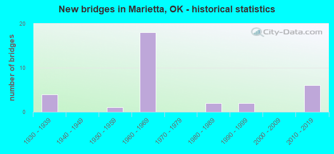
- New bridges - historical statistics
- 41930-1939
- 11950-1959
- 181960-1969
- 21980-1989
- 21990-1999
- 62010-2019


- Bridge Condition - Deck
- 45.5%Good
- 45.5%Satisfactory
- 9.1%Fair

- Bridge Condition - Superstructure
- 9.1%Very good
- 72.7%Good
- 18.2%Satisfactory

- Bridge Condition - Substructure
- 9.1%Very good
- 63.6%Good
- 27.3%Satisfactory

- Bridge Condition - Channel
- 18.8%Very good
- 12.5%Good
- 56.3%Satisfactory
- 12.5%Fair

- Bridge Condition - Culverts
- 30.8%Very good
- 30.8%Good
- 30.8%Satisfactory
- 7.7%Fair
Find on map >> Show street view
Structure Number: 5856, Location: .5 W 1. S OF I-35 (Lat: 33.925836, Lng: -97.145092), Route carried "on" structure: County highway E2130, Year Built: 1938, Year Reconstructed: 2006, Status: Open, Structure Length: 0.76m (2.49ft), Average Daily Traffic: 100 (year 2020), Truck Traffic: 10%, Average Future Daily Traffic: 160 (year 2040), Design Load: HS 20, Features Intersected: CREEK
Minimum Vertical Clearance: 30+ m (98+ ft), Kilometerpoint: 1.287, Lanes on structure: 2, Owner: County Highway Agency, Approaching Roadway Width: 6.4m (21.0ft), Skew: 3 degrees, Material/Design: Concrete, Design/Construction: Culvert, Number Of Spans In Main Unit: 2, Length of Maximum Span: 3.7m (12.1ft), Curb-To-Curb Width: 10.4m (34.1ft), Out-to-Out Width: 11.1m (36.4ft)
Condition: Channel: Satisfactory, Culverts: Good, Operating Rating: 37.2 metric tons, Method Used To Determine Operating Rating: Load Factor (LF), Inventory Rating: 21.8 metric tons, Method Used To Determine Inventory Rating: Load Factor (LF), Structural Evaluation: Equal to present minimum criteria, Deck Geometry: Superior to present desirable criteria, Waterway Adequacy: Better than present minimum criteria, Approach Roadway Alignment: Equal to present desirable criteria, Length Of Structure Improvement: 2.98m (9.78ft), Designated Inspection Frequency: Every 24 months, Inspection Date: Febuary 2021, Bridge Improvement Cost: $100,000, Roadway Improvement Cost: $75,000, Total Project Cost: $225,000 ( Estimate for 2015), Deck Structure Type: Concrete Cast-file-Place, Wearing Surface/Protective System: Wearing Surface: Bituminous
Find on map >> Show street view
Structure Number: 5861, Location: 0.2 MI E OF US 77 (Lat: 33.896806, Lng: -97.122189), Route carried "on" structure: County highway 4334C, Year Built: 1938, Status: Open, Structure Length: 0.64m (2.10ft), Average Daily Traffic: 136 (year 2020), Truck Traffic: 15%, Average Future Daily Traffic: 218 (year 2040), Design Load: HS 20, Features Intersected: CREEK
Minimum Vertical Clearance: 30+ m (98+ ft), Kilometerpoint: 0.451, Lanes on structure: 2, Owner: County Highway Agency, Approaching Roadway Width: 6.7m (22.0ft), Material/Design: Concrete, Design/Construction: Culvert, Number Of Spans In Main Unit: 2, Length of Maximum Span: 3.0m (9.8ft), Curb-To-Curb Width: 7.9m (25.9ft), Out-to-Out Width: 8.6m (28.2ft)
Condition: Channel: Satisfactory, Culverts: Satisfactory, Operating Rating: 37.2 metric tons, Method Used To Determine Operating Rating: Load Factor (LF), Inventory Rating: 21.8 metric tons, Method Used To Determine Inventory Rating: Load Factor (LF), Structural Evaluation: Equal to present minimum criteria, Deck Geometry: Somewhat better than minimum adequacy, Waterway Adequacy: Equal to present minimum criteria, Approach Roadway Alignment: Equal to present desirable criteria, Length Of Structure Improvement: 2.72m (8.92ft), Designated Inspection Frequency: Every 24 months, Inspection Date: Febuary 2021, Bridge Improvement Cost: $100,000, Roadway Improvement Cost: $75,000, Total Project Cost: $225,000 ( Estimate for 2015), Deck Structure Type: Concrete Cast-file-Place, Wearing Surface/Protective System: Wearing Surface: Bituminous
Find on map >> Show street view
Structure Number: 5862, Location: 1.5 E 2.8 S OF US 77 (Lat: 33.896794, Lng: -97.101308), Route carried "on" structure: County highway 4316, Year Built: 1938, Status: Open, Structure Length: 0.64m (2.10ft), Average Daily Traffic: 75 (year 2020), Truck Traffic: 15%, Average Future Daily Traffic: 120 (year 2040), Design Load: HS 20, Features Intersected: CREEK, Facility Carried by Structure: 4332 MAJOR
Minimum Vertical Clearance: 30+ m (98+ ft), Kilometerpoint: 0.805, Lanes on structure: 2, Owner: County Highway Agency, Approaching Roadway Width: 6.7m (22.0ft), Material/Design: Concrete, Design/Construction: Culvert, Number Of Spans In Main Unit: 2, Length of Maximum Span: 3.0m (9.8ft), Curb-To-Curb Width: 7.6m (24.9ft), Out-to-Out Width: 8.2m (26.9ft)
Condition: Channel: Fair, Culverts: Good, Operating Rating: 37.2 metric tons, Method Used To Determine Operating Rating: Load Factor (LF), Inventory Rating: 21.8 metric tons, Method Used To Determine Inventory Rating: Load Factor (LF), Structural Evaluation: Equal to present minimum criteria, Deck Geometry: Equal to present minimum criteria, Waterway Adequacy: Somewhat better than minimum adequacy, Approach Roadway Alignment: Equal to present desirable criteria, Length Of Structure Improvement: 2.72m (8.92ft), Designated Inspection Frequency: Every 24 months, Inspection Date: Febuary 2021, Bridge Improvement Cost: $100,000, Roadway Improvement Cost: $75,000, Total Project Cost: $225,000 ( Estimate for 2015)
Find on map >> Show street view
Structure Number: 6433, Location: .06W OF US 77 (Lat: 33.882244, Lng: -97.127569), Route carried "on" structure: County highway 4315, Year Built: 1938, Status: Open, Structure Length: 1.49m (4.89ft), Average Daily Traffic: 100 (year 2020), Truck Traffic: 15%, Average Future Daily Traffic: 160 (year 2040), Design Load: H 20, Features Intersected: CREEK, Facility Carried by Structure: 4330C MAJOR
Minimum Vertical Clearance: 30+ m (98+ ft), Kilometerpoint: 0.097, Lanes on structure: 2, Owner: County Highway Agency, Approaching Roadway Width: 6.7m (22.0ft), Material/Design: Steel, Design/Construction: Stringer/Multi-beam, Number Of Spans In Main Unit: 1, Length of Maximum Span: 14.6m (47.9ft), Curb-To-Curb Width: 6.7m (22.0ft), Out-to-Out Width: 7.6m (24.9ft)
Condition: Deck: Fair, Superstructure: Satisfactory, Substructure: Satisfactory, Channel: Satisfactory, Operating Rating: 45.4 metric tons, Method Used To Determine Operating Rating: Load Factor (LF), Inventory Rating: 27.2 metric tons, Method Used To Determine Inventory Rating: Load Factor (LF), Structural Evaluation: Equal to present minimum criteria, Deck Geometry: Somewhat better than minimum adequacy, Waterway Adequacy: Equal to present minimum criteria, Approach Roadway Alignment: Equal to present desirable criteria, Length Of Structure Improvement: 4.26m (13.98ft), Designated Inspection Frequency: Every 24 months, Inspection Date: Febuary 2021, Bridge Improvement Cost: $218,000, Roadway Improvement Cost: $120,000, Total Project Cost: $346,000 ( Estimate for 2015), Deck Structure Type: Concrete Cast-file-Place, Wearing Surface/Protective System: Wearing Surface: Monolithic Concrete
Find on map >> Show street view
Structure Number: 12875, Location: 1.4 MI N JCT SH32 (Lat: 33.960375, Lng: -97.091425), Route carried "on" structure: State highway 77S, Year Built: 1953, Status: Open, Structure Length: 0.79m (2.59ft), Average Daily Traffic: 370 (year 2020), Truck Traffic: 15%, Average Future Daily Traffic: 592 (year 2040), Design Load: HS 20, Features Intersected: CREEK, Facility Carried by Structure: S.H. 77 SCENIC
Minimum Vertical Clearance: 30+ m (98+ ft), Kilometerpoint: 2.205, Lanes on structure: 2, Owner: State Highway Agency, Approaching Roadway Width: 9.1m (29.9ft), Skew: 6 degrees, Material/Design: Concrete, Design/Construction: Culvert, Number Of Spans In Main Unit: 2, Length of Maximum Span: 3.0m (9.8ft), Curb-To-Curb Width: 12.8m (42.0ft), Out-to-Out Width: 13.4m (44.0ft)
Condition: Channel: Satisfactory, Culverts: Satisfactory, Operating Rating: 38.3 metric tons, Method Used To Determine Operating Rating: Load Factor (LF), Inventory Rating: 23.0 metric tons, Method Used To Determine Inventory Rating: Load Factor (LF), Structural Evaluation: Equal to present minimum criteria, Deck Geometry: Superior to present desirable criteria, Waterway Adequacy: Equal to present desirable criteria, Approach Roadway Alignment: Equal to present desirable criteria, Length Of Structure Improvement: 0.79m (2.59ft), Designated Inspection Frequency: Every 24 months, Inspection Date: Febuary 2020, Bridge Improvement Cost: $230,000, Roadway Improvement Cost: $380,000, Total Project Cost: $644,000 ( Estimate for 2015)
Find on map >> Show street view
Structure Number: 15493, Location: 11.0 MI N TX S/L (Lat: 33.877889, Lng: -97.134083), Route carried "on" structure: Interstate 35, Year Built: 1962, Status: Open, Structure Length: 1.49m (4.89ft), Average Daily Traffic: 25,500 (year 2020), Truck Traffic: 36%, Average Future Daily Traffic: 40,800 (year 2040), Design Load: HS 20, Features Intersected: CLOUDS BRANCH CREEK
Minimum Vertical Clearance: 30+ m (98+ ft), Kilometerpoint: 17.762, Lanes on structure: 4, Base Highway Network: Yes, Owner: State Highway Agency, Approaching Roadway Width: 34.4m (112.9ft), Skew: 23 degrees, Material/Design: Concrete, Design/Construction: Culvert, Number Of Spans In Main Unit: 3, Length of Maximum Span: 4.3m (14.1ft)
Condition: Channel: Satisfactory, Culverts: Fair, Operating Rating: 44.5 metric tons, Method Used To Determine Operating Rating: Load Factor (LF), Inventory Rating: 32.7 metric tons, Method Used To Determine Inventory Rating: Load Factor (LF), Structural Evaluation: Somewhat better than minimum adequacy, Waterway Adequacy: Equal to present desirable criteria, Approach Roadway Alignment: Equal to present desirable criteria, Length Of Structure Improvement: 1.49m (4.89ft), Designated Inspection Frequency: Every 24 months, Inspection Date: January 2021, Bridge Improvement Cost: $398,000, Roadway Improvement Cost: $656,000, Total Project Cost: $1,113,000 ( Estimate for 2015)
Find on map >> Show street view
Structure Number: 15548, Location: 11.3 MI N TX S/L (Lat: 33.882331, Lng: -97.134489), Route carried "on" structure: County highway 4315, Year Built: 1962, Status: Open, Structure Length: 5.24m (17.19ft), Average Daily Traffic: 575 (year 2020), Truck Traffic: 11%, Average Future Daily Traffic: 920 (year 2040), Design Load: H 15, Features Intersected: I-35 UNDER
Minimum Vertical Clearance: 30+ m (98+ ft), Kilometerpoint: 18.247, Lanes on structure: 2, Lanes under structure: 4, Owner: State Highway Agency, Approaching Roadway Width: 7.3m (24.0ft), Material/Design: Concrete continuous, Design/Construction: Slab, Number Of Spans In Main Unit: 4, Length of Maximum Span: 16.8m (55.1ft), Curb or Sidewalk Widths: Left: 0.5m (1.6ft), Right: 0.5m (1.6ft), Curb-To-Curb Width: 7.3m (24.0ft), Out-to-Out Width: 8.8m (28.9ft)
Condition: Deck: Satisfactory, Superstructure: Good, Substructure: Good, Operating Rating: 37.2 metric tons, Method Used To Determine Operating Rating: Load Factor (LF), Inventory Rating: 22.7 metric tons, Method Used To Determine Inventory Rating: Load Factor (LF), Structural Evaluation: Equal to present minimum criteria, Deck Geometry: Meets minimum limits, Underclear: Meets minimum limits, Approach Roadway Alignment: Equal to present desirable criteria, Length Of Structure Improvement: 8.40m (27.56ft), Designated Inspection Frequency: Every 24 months, Inspection Date: January 2021, Bridge Improvement Cost: $689,000, Roadway Improvement Cost: $1,137,000, Total Project Cost: $1,929,000 ( Estimate for 2015), Deck Structure Type: Concrete Cast-file-Place, Wearing Surface/Protective System: Wearing Surface: Monolithic Concrete
Find on map >> Show street view
Structure Number: 15702, Location: 13.9 MI N TX S/L (Lat: 33.919967, Lng: -97.133283), Route carried "on" structure: Interstate 35, Year Built: 1963, Status: Open, Structure Length: 1.46m (4.79ft), Average Daily Traffic: 14,200 (year 2020), Truck Traffic: 36%, Average Future Daily Traffic: 22,720 (year 2040), Design Load: HS 20, Features Intersected: BILL'S CREEK
Minimum Vertical Clearance: 30+ m (98+ ft), Kilometerpoint: 22.413, Lanes on structure: 2, Base Highway Network: Yes, Owner: State Highway Agency, Approaching Roadway Width: 34.4m (112.9ft), Skew: 14 degrees, Material/Design: Concrete, Design/Construction: Culvert, Number Of Spans In Main Unit: 3, Length of Maximum Span: 3.0m (9.8ft)
Condition: Channel: Satisfactory, Culverts: Satisfactory, Operating Rating: 90.7 metric tons, Method Used To Determine Operating Rating: Load Factor (LF), Inventory Rating: 71.8 metric tons, Method Used To Determine Inventory Rating: Load Factor (LF), Structural Evaluation: Equal to present minimum criteria, Waterway Adequacy: Equal to present desirable criteria, Approach Roadway Alignment: Equal to present desirable criteria, Length Of Structure Improvement: 1.46m (4.79ft), Designated Inspection Frequency: Every 24 months, Inspection Date: January 2021, Bridge Improvement Cost: $282,000, Roadway Improvement Cost: $466,000, Total Project Cost: $790,000 ( Estimate for 2015)
Find on map >> Show street view
Structure Number: 15742, Location: 14.3 MI N TX S/L (Lat: 33.925911, Lng: -97.134231), Route carried "on" structure: County highway E3130, Year Built: 1963, Status: Posted for load, Structure Length: 3.57m (11.71ft), Average Daily Traffic: 300 (year 2020), Truck Traffic: 15%, Average Future Daily Traffic: 480 (year 2040), Design Load: H 15, Features Intersected: I-35 NB UNDER, Facility Carried by Structure: CO. RD. E2130
Minimum Vertical Clearance: 30+ m (98+ ft), Kilometerpoint: 23.089, Lanes on structure: 2, Lanes under structure: 2, Owner: State Highway Agency, Approaching Roadway Width: 7.3m (24.0ft), Material/Design: Concrete continuous, Design/Construction: Slab, Number Of Spans In Main Unit: 3, Length of Maximum Span: 13.7m (44.9ft), Curb or Sidewalk Widths: Left: 0.5m (1.6ft), Right: 0.5m (1.6ft), Curb-To-Curb Width: 7.3m (24.0ft), Out-to-Out Width: 8.8m (28.9ft)
Condition: Deck: Satisfactory, Superstructure: Good, Substructure: Good, Operating Rating: 36.3 metric tons, Method Used To Determine Operating Rating: Allowable Stress (AS), Inventory Rating: 24.5 metric tons, Method Used To Determine Inventory Rating: Allowable Stress (AS), Structural Evaluation: Equal to present minimum criteria, Deck Geometry: High priority of replacement, Underclear: Meets minimum limits, Approach Roadway Alignment: Equal to present minimum criteria, Bridge Posting: Required (Relationship of Operating Rating to Maximum Legal Load: 0.1 - 9.9% below), Length Of Structure Improvement: 5.60m (18.37ft), Designated Inspection Frequency: Every 24 months, Inspection Date: January 2021, Bridge Improvement Cost: $486,000, Roadway Improvement Cost: $802,000, Total Project Cost: $1,361,000 ( Estimate for 2015), Deck Structure Type: Concrete Cast-file-Place, Wearing Surface/Protective System: Wearing Surface: Monolithic Concrete
Find on map >> Show street view
Structure Number: 15743, Location: 14.3 MI N TX S/L (Lat: 33.925911, Lng: -97.135256), Route carried "on" structure: County highway E2130, Year Built: 1963, Status: Posted for load, Structure Length: 3.57m (11.71ft), Average Daily Traffic: 300 (year 2020), Truck Traffic: 15%, Average Future Daily Traffic: 480 (year 2040), Design Load: H 15, Features Intersected: I-35 SB UNDER
Minimum Vertical Clearance: 30+ m (98+ ft), Kilometerpoint: 23.089, Lanes on structure: 2, Lanes under structure: 2, Owner: State Highway Agency, Approaching Roadway Width: 7.3m (24.0ft), Material/Design: Concrete continuous, Design/Construction: Slab, Number Of Spans In Main Unit: 3, Length of Maximum Span: 13.7m (44.9ft), Curb or Sidewalk Widths: Left: 0.5m (1.6ft), Right: 0.5m (1.6ft), Curb-To-Curb Width: 7.3m (24.0ft), Out-to-Out Width: 8.8m (28.9ft)
Condition: Deck: Good, Superstructure: Good, Substructure: Good, Operating Rating: 30.1 metric tons, Method Used To Determine Operating Rating: Load Factor (LF), Inventory Rating: 18.1 metric tons, Method Used To Determine Inventory Rating: Load Factor (LF), Structural Evaluation: Somewhat better than minimum adequacy, Deck Geometry: High priority of replacement, Underclear: Somewhat better than minimum adequacy, Approach Roadway Alignment: Equal to present desirable criteria, Bridge Posting: Required (Relationship of Operating Rating to Maximum Legal Load: 0.1 - 9.9% below), Length Of Structure Improvement: 5.60m (18.37ft), Designated Inspection Frequency: Every 24 months, Inspection Date: January 2021, Bridge Improvement Cost: $486,000, Roadway Improvement Cost: $802,000, Total Project Cost: $1,361,000 ( Estimate for 2015), Deck Structure Type: Concrete Cast-file-Place, Wearing Surface/Protective System: Wearing Surface: Bituminous
Find on map >> Show street view
Structure Number: 158, Location: 12.3 MI N TX S/L (Lat: 33.896892, Lng: -97.134592), Route carried "on" structure: County highway E2150, Year Built: 1963, Status: Open, Structure Length: 5.64m (18.50ft), Average Daily Traffic: 300 (year 2020), Truck Traffic: 15%, Average Future Daily Traffic: 480 (year 2040), Design Load: H 15, Features Intersected: I-35 UNDER
Minimum Vertical Clearance: 30+ m (98+ ft), Kilometerpoint: 19.854, Lanes on structure: 2, Lanes under structure: 4, Owner: State Highway Agency, Approaching Roadway Width: 7.3m (24.0ft), Material/Design: Steel, Design/Construction: Stringer/Multi-beam, Number Of Spans In Main Unit: 4, Length of Maximum Span: 18.3m (60.0ft), Curb or Sidewalk Widths: Left: 0.5m (1.6ft), Right: 0.5m (1.6ft), Curb-To-Curb Width: 7.3m (24.0ft), Out-to-Out Width: 8.2m (26.9ft)
Condition: Deck: Satisfactory, Superstructure: Good, Substructure: Good, Operating Rating: 47.2 metric tons, Method Used To Determine Operating Rating: Load Factor (LF), Inventory Rating: 28.1 metric tons, Method Used To Determine Inventory Rating: Load Factor (LF), Structural Evaluation: Better than present minimum criteria, Deck Geometry: Somewhat better than minimum adequacy, Underclear: Somewhat better than minimum adequacy, Approach Roadway Alignment: Equal to present desirable criteria, Length Of Structure Improvement: 8.40m (27.56ft), Designated Inspection Frequency: Every 24 months, Inspection Date: January 2021, Bridge Improvement Cost: $689,000, Roadway Improvement Cost: $1,137,000, Total Project Cost: $1,929,000 ( Estimate for 2015), Deck Structure Type: Concrete Cast-file-Place, Wearing Surface/Protective System: Wearing Surface: Bituminous
Find on map >> Show street view
Structure Number: 16333, Location: .3 W 1. S OF US 77 (Lat: 33.925803, Lng: -97.132642), Route carried "on" structure: City street E2130, Year Built: 1965, Status: Open, Structure Length: 0.79m (2.59ft), Average Daily Traffic: 100 (year 2020), Truck Traffic: 5%, Average Future Daily Traffic: 160 (year 2040), Design Load: HS 20, Features Intersected: BILL'S CREEK
Minimum Vertical Clearance: 30+ m (98+ ft), Kilometerpoint: 1.127, Lanes on structure: 2, Owner: City or Municipal Highway Agency, Maintenance Responsibility: County Highway Agency, Approaching Roadway Width: 6.1m (20.0ft), Material/Design: Concrete, Design/Construction: Culvert, Number Of Spans In Main Unit: 3, Length of Maximum Span: 2.4m (7.9ft)
Condition: Channel: Good, Culverts: Very good, Operating Rating: 37.2 metric tons, Method Used To Determine Operating Rating: Load Factor (LF), Inventory Rating: 21.8 metric tons, Method Used To Determine Inventory Rating: Load Factor (LF), Structural Evaluation: Equal to present minimum criteria, Waterway Adequacy: Equal to present desirable criteria, Approach Roadway Alignment: Equal to present desirable criteria, Length Of Structure Improvement: 3.05m (10.01ft), Designated Inspection Frequency: Every 24 months, Inspection Date: Febuary 2021, Bridge Improvement Cost: $100,000, Roadway Improvement Cost: $75,000, Total Project Cost: $225,000 ( Estimate for 2015)
Find on map >> Show street view
Structure Number: 164, Location: 3.2 MI N JCT SH32 (Lat: 33.985939, Lng: -97.137856), Route carried "on" structure: Interstate 35, Year Built: 1965, Status: Open, Structure Length: 1.43m (4.69ft), Average Daily Traffic: 13,450 (year 2020), Truck Traffic: 36%, Average Future Daily Traffic: 21,520 (year 2040), Design Load: HS 20, Features Intersected: SHIGGIN CREEK
Minimum Vertical Clearance: 30+ m (98+ ft), Kilometerpoint: 48.086, Lanes on structure: 2, Base Highway Network: Yes, Owner: State Highway Agency, Approaching Roadway Width: 34.4m (112.9ft), Skew: 13 degrees, Material/Design: Concrete, Design/Construction: Culvert, Number Of Spans In Main Unit: 3, Length of Maximum Span: 4.3m (14.1ft)
Condition: Channel: Satisfactory, Culverts: Good, Operating Rating: 44.5 metric tons, Method Used To Determine Operating Rating: Load Factor (LF), Inventory Rating: 32.7 metric tons, Method Used To Determine Inventory Rating: Load Factor (LF), Structural Evaluation: Better than present minimum criteria, Waterway Adequacy: Equal to present desirable criteria, Approach Roadway Alignment: Equal to present desirable criteria, Length Of Structure Improvement: 1.43m (4.69ft), Designated Inspection Frequency: Every 24 months, Inspection Date: January 2021, Bridge Improvement Cost: $390,000, Roadway Improvement Cost: $643,000, Total Project Cost: $1,092,000 ( Estimate for 2015)
Find on map >> Show street view
Structure Number: 16401, Location: 3.2 MI N JCT SH32 (Lat: 33.986933, Lng: -97.136819), Route carried "on" structure: Interstate 35, Year Built: 1965, Status: Open, Structure Length: 1.43m (4.69ft), Average Daily Traffic: 13,400 (year 2020), Truck Traffic: 36%, Average Future Daily Traffic: 21,440 (year 2040), Design Load: HS 20, Features Intersected: SHIGGIN CREEK
Minimum Vertical Clearance: 30+ m (98+ ft), Kilometerpoint: 48.086, Lanes on structure: 2, Base Highway Network: Yes, Owner: State Highway Agency, Approaching Roadway Width: 34.4m (112.9ft), Skew: 13 degrees, Material/Design: Concrete, Design/Construction: Culvert, Number Of Spans In Main Unit: 3, Length of Maximum Span: 4.3m (14.1ft)
Condition: Culverts: Good, Operating Rating: 44.5 metric tons, Method Used To Determine Operating Rating: Load Factor (LF), Inventory Rating: 32.7 metric tons, Method Used To Determine Inventory Rating: Load Factor (LF), Structural Evaluation: Better than present minimum criteria, Waterway Adequacy: Equal to present desirable criteria, Approach Roadway Alignment: Equal to present desirable criteria, Length Of Structure Improvement: 1.43m (4.69ft), Designated Inspection Frequency: Every 24 months, Inspection Date: January 2021, Bridge Improvement Cost: $410,000, Roadway Improvement Cost: $677,000, Total Project Cost: $1,149,000 ( Estimate for 2015)
Find on map >> Show street view
Structure Number: 16475, Location: 2.6 MI N JCT SH32 (Lat: 33.976514, Lng: -97.134847), Route carried "on" structure: Interstate 35, Year Built: 1965, Status: Open, Structure Length: 3.23m (10.60ft), Average Daily Traffic: 13,800 (year 2020), Truck Traffic: 36%, Average Future Daily Traffic: 22,080 (year 2040), Design Load: HS 20, Features Intersected: CO. RD. 4328C UNDER
Minimum Vertical Clearance: 30+ m (98+ ft), Kilometerpoint: 28.704, Lanes on structure: 2, Lanes under structure: 2, Base Highway Network: Yes, Owner: State Highway Agency, Approaching Roadway Width: 11.3m (37.1ft), Skew: 10 degrees, Material/Design: Concrete continuous, Design/Construction: Slab, Number Of Spans In Main Unit: 3, Length of Maximum Span: 12.2m (40.0ft), Curb-To-Curb Width: 11.3m (37.1ft), Out-to-Out Width: 12.2m (40.0ft)
Condition: Deck: Satisfactory, Superstructure: Good, Substructure: Good, Operating Rating: 46.3 metric tons, Method Used To Determine Operating Rating: Load Factor (LF), Inventory Rating: 28.1 metric tons, Method Used To Determine Inventory Rating: Load Factor (LF), Structural Evaluation: Better than present minimum criteria, Deck Geometry: Somewhat better than minimum adequacy, Underclear: High priority of replacement, Approach Roadway Alignment: Equal to present desirable criteria, Length Of Structure Improvement: 5.62m (18.44ft), Designated Inspection Frequency: Every 24 months, Inspection Date: January 2021, Bridge Improvement Cost: $488,000, Roadway Improvement Cost: $805,000, Total Project Cost: $1,365,000 ( Estimate for 2015), Deck Structure Type: Concrete Cast-file-Place, Wearing Surface/Protective System: Wearing Surface: Monolithic Concrete
Find on map >> Show street view
Structure Number: 16476, Location: 2.6 MI N JCT SH32 (Lat: 33.976517, Lng: -97.133964), Route carried "on" structure: Interstate 35, Year Built: 1965, Status: Open, Structure Length: 3.23m (10.60ft), Average Daily Traffic: 13,400 (year 2020), Truck Traffic: 36%, Average Future Daily Traffic: 21,440 (year 2040), Design Load: HS 20, Features Intersected: CO. RD. 4328C UNDER
Minimum Vertical Clearance: 30+ m (98+ ft), Kilometerpoint: 28.704, Lanes on structure: 2, Lanes under structure: 2, Base Highway Network: Yes, Owner: State Highway Agency, Approaching Roadway Width: 11.3m (37.1ft), Skew: 10 degrees, Material/Design: Concrete continuous, Design/Construction: Slab, Number Of Spans In Main Unit: 3, Length of Maximum Span: 12.2m (40.0ft), Curb-To-Curb Width: 11.3m (37.1ft), Out-to-Out Width: 12.2m (40.0ft)
Condition: Deck: Good, Superstructure: Good, Substructure: Satisfactory, Operating Rating: 47.2 metric tons, Method Used To Determine Operating Rating: Load Factor (LF), Inventory Rating: 28.1 metric tons, Method Used To Determine Inventory Rating: Load Factor (LF), Structural Evaluation: Equal to present minimum criteria, Deck Geometry: Somewhat better than minimum adequacy, Underclear: High priority of replacement, Approach Roadway Alignment: Equal to present desirable criteria, Length Of Structure Improvement: 5.62m (18.44ft), Designated Inspection Frequency: Every 24 months, Inspection Date: January 2021, Bridge Improvement Cost: $488,000, Roadway Improvement Cost: $805,000, Total Project Cost: $1,365,000 ( Estimate for 2015), Deck Structure Type: Concrete Cast-file-Place, Wearing Surface/Protective System: Wearing Surface: Monolithic Concrete
Find on map >> Show street view
Structure Number: 20487, Location: 2.1W OF US 77 (Lat: 33.882156, Lng: -97.163244), Route carried "on" structure: County highway 4315, Year Built: 1983, Status: Open, Structure Length: 1.83m (6.00ft), Average Daily Traffic: 100 (year 2020), Truck Traffic: 15%, Average Future Daily Traffic: 160 (year 2040), Design Load: HS 20, Features Intersected: BILL'S CREEK, Facility Carried by Structure: 4330C MAJOR
Minimum Vertical Clearance: 30+ m (98+ ft), Kilometerpoint: 3.442, Lanes on structure: 2, Owner: County Highway Agency, Approaching Roadway Width: 6.7m (22.0ft), Material/Design: Prestressed concrete, Design/Construction: Stringer/Multi-beam, Number Of Spans In Main Unit: 1, Length of Maximum Span: 17.7m (58.1ft), Curb-To-Curb Width: 8.2m (26.9ft), Out-to-Out Width: 8.8m (28.9ft)
Condition: Deck: Satisfactory, Superstructure: Satisfactory, Substructure: Good, Channel: Satisfactory, Operating Rating: 43.5 metric tons, Method Used To Determine Operating Rating: Load Factor (LF), Inventory Rating: 26.3 metric tons, Method Used To Determine Inventory Rating: Load Factor (LF), Structural Evaluation: Equal to present minimum criteria, Deck Geometry: Equal to present minimum criteria, Waterway Adequacy: Better than present minimum criteria, Approach Roadway Alignment: Meets minimum limits, Length Of Structure Improvement: 4.75m (15.58ft), Designated Inspection Frequency: Every 24 months, Inspection Date: Febuary 2021, Bridge Improvement Cost: $243,000, Roadway Improvement Cost: $134,000, Total Project Cost: $387,000 ( Estimate for 2015), Deck Structure Type: Concrete Cast-file-Place, Wearing Surface/Protective System: Wearing Surface: Monolithic Concrete
Find on map >> Show street view
Structure Number: 21875, Location: 0.7 MI W OF US 77 (Lat: 33.976575, Lng: -97.137711), Route carried "on" structure: County highway 4328C, Year Built: 1988, Status: Open, Structure Length: 1.40m (4.59ft), Average Daily Traffic: 82 (year 2020), Truck Traffic: 10%, Average Future Daily Traffic: 131 (year 2040), Design Load: HS 20, Features Intersected: CREEK
Minimum Vertical Clearance: 30+ m (98+ ft), Kilometerpoint: 3.990, Lanes on structure: 2, Owner: County Highway Agency, Approaching Roadway Width: 4.6m (15.1ft), Material/Design: Concrete, Design/Construction: Culvert, Number Of Spans In Main Unit: 3, Length of Maximum Span: 5.2m (17.1ft), Curb-To-Curb Width: 12.8m (42.0ft), Out-to-Out Width: 13.4m (44.0ft)
Condition: Channel: Fair, Culverts: Satisfactory, Operating Rating: 37.2 metric tons, Method Used To Determine Operating Rating: Load Factor (LF), Inventory Rating: 21.8 metric tons, Method Used To Determine Inventory Rating: Load Factor (LF), Structural Evaluation: Equal to present minimum criteria, Deck Geometry: Superior to present desirable criteria, Waterway Adequacy: Equal to present minimum criteria, Approach Roadway Alignment: Equal to present desirable criteria, Length Of Structure Improvement: 4.12m (13.52ft), Designated Inspection Frequency: Every 24 months, Inspection Date: March 2021, Bridge Improvement Cost: $100,000, Roadway Improvement Cost: $75,000, Total Project Cost: $225,000 ( Estimate for 2015), Deck Structure Type: Concrete Cast-file-Place, Wearing Surface/Protective System: Wearing Surface: Monolithic Concrete
Find on map >> Show street view
Structure Number: 22579, Location: 1.8 W 3. S OF US 77 (Lat: 33.896819, Lng: -97.157039), Route carried "on" structure: County highway E2150, Year Built: 1990, Status: Open, Structure Length: 2.35m (7.71ft), Average Daily Traffic: 100 (year 2020), Truck Traffic: 10%, Average Future Daily Traffic: 160 (year 2040), Design Load: HS 20, Features Intersected: BILL'S CREEK
Minimum Vertical Clearance: 30+ m (98+ ft), Kilometerpoint: 0.322, Lanes on structure: 2, Owner: County Highway Agency, Approaching Roadway Width: 6.7m (22.0ft), Material/Design: Prestressed concrete, Design/Construction: Stringer/Multi-beam, Number Of Spans In Main Unit: 1, Length of Maximum Span: 22.3m (73.2ft), Curb-To-Curb Width: 8.2m (26.9ft), Out-to-Out Width: 8.5m (27.9ft)
Condition: Deck: Good, Superstructure: Good, Substructure: Good, Channel: Good, Operating Rating: 54.4 metric tons, Method Used To Determine Operating Rating: Load Factor (LF), Inventory Rating: 32.7 metric tons, Method Used To Determine Inventory Rating: Load Factor (LF), Structural Evaluation: Better than present minimum criteria, Deck Geometry: Equal to present minimum criteria, Waterway Adequacy: Better than present minimum criteria, Approach Roadway Alignment: Equal to present desirable criteria, Length Of Structure Improvement: 5.43m (17.81ft), Designated Inspection Frequency: Every 24 months, Inspection Date: Febuary 2021, Bridge Improvement Cost: $277,000, Roadway Improvement Cost: $152,000, Total Project Cost: $442,000 ( Estimate for 2015), Deck Structure Type: Concrete Cast-file-Place, Wearing Surface/Protective System: Wearing Surface: Monolithic Concrete
Find on map >> Show street view
Structure Number: 24299, Location: 4.7 S 1.0 W US-77/SH-32W (Lat: 33.873747, Lng: -97.143403), Route carried "on" structure: County highway N3290, Year Built: 1998, Status: Open, Structure Length: 2.83m (9.28ft), Average Daily Traffic: 100 (year 2020), Truck Traffic: 10%, Average Future Daily Traffic: 160 (year 2040), Design Load: HS 20, Features Intersected: CLOUDS BRANCH CREEK
Minimum Vertical Clearance: 30+ m (98+ ft), Kilometerpoint: 1.127, Lanes on structure: 2, Owner: County Highway Agency, Approaching Roadway Width: 6.7m (22.0ft), Material/Design: Prestressed concrete, Design/Construction: Stringer/Multi-beam, Number Of Spans In Main Unit: 1, Length of Maximum Span: 27.4m (89.9ft), Curb-To-Curb Width: 8.2m (26.9ft), Out-to-Out Width: 8.6m (28.2ft)
Condition: Deck: Good, Superstructure: Very good, Substructure: Satisfactory, Channel: Satisfactory, Operating Rating: 63.5 metric tons, Method Used To Determine Operating Rating: Load Factor (LF), Inventory Rating: 38.1 metric tons, Method Used To Determine Inventory Rating: Load Factor (LF), Structural Evaluation: Equal to present minimum criteria, Deck Geometry: Equal to present minimum criteria, Waterway Adequacy: Equal to present desirable criteria, Approach Roadway Alignment: Equal to present desirable criteria, Length Of Structure Improvement: 5.99m (19.65ft), Designated Inspection Frequency: Every 24 months, Inspection Date: Febuary 2021, Bridge Improvement Cost: $306,000, Roadway Improvement Cost: $168,000, Total Project Cost: $488,000 ( Estimate for 2015), Deck Structure Type: Concrete Cast-file-Place, Wearing Surface/Protective System: Wearing Surface: Monolithic Concrete
Find on map >> Show street view
Structure Number: 29688, Location: 15.3N TEXAS S/L (Lat: 33.940000, Lng: -97.134722), Route carried "on" structure: Interstate 35, Year Built: 2012, Status: Open, Structure Length: 6.36m (20.87ft), Average Daily Traffic: 14,200 (year 2020), Truck Traffic: 36%, Average Future Daily Traffic: 22,720 (year 2040), Design Load: HL 93, Features Intersected: S.H. 32 UNDER
Minimum Vertical Clearance: 30+ m (98+ ft), Kilometerpoint: 24.683, Lanes on structure: 2, Lanes under structure: 4, Base Highway Network: Yes, Owner: State Highway Agency, Approaching Roadway Width: 11.6m (38.1ft), Material/Design: Prestressed concrete, Design/Construction: Stringer/Multi-beam, Number Of Spans In Main Unit: 4, Length of Maximum Span: 17.1m (56.1ft), Curb-To-Curb Width: 11.6m (38.1ft), Out-to-Out Width: 12.5m (41.0ft)
Condition: Deck: Good, Superstructure: Good, Substructure: Very good, Operating Rating: 67.1 metric tons, Method Used To Determine Operating Rating: Load and Resistance Factor (LRFR), Inventory Rating: 39.0 metric tons, Method Used To Determine Inventory Rating: Load and Resistance Factor (LRFR), Structural Evaluation: Better than present minimum criteria, Deck Geometry: Equal to present minimum criteria, Underclear: Superior to present desirable criteria, Approach Roadway Alignment: Equal to present desirable criteria, Designated Inspection Frequency: Every 24 months, Inspection Date: January 2021, Deck Structure Type: Concrete Cast-file-Place, Wearing Surface/Protective System: Wearing Surface: Monolithic Concrete, Deck Protection: Epoxy Coated Reinforcing
Find on map >> Show street view
Structure Number: 30466, Location: 1.2 W OF JCT U.S. 77 (Lat: 33.940278, Lng: -97.149444), Route carried "on" structure: State highway 32, Year Built: 2018, Status: Open, Structure Length: 0.70m (2.30ft), Average Daily Traffic: 3,800 (year 2020), Truck Traffic: 16%, Average Future Daily Traffic: 6,080 (year 2040), Design Load: HL 93, Features Intersected: CREEK
Minimum Vertical Clearance: 30+ m (98+ ft), Kilometerpoint: 61.163, Lanes on structure: 2, Owner: State Highway Agency, Approaching Roadway Width: 12.8m (42.0ft), Material/Design: Concrete, Design/Construction: Culvert, Number Of Spans In Main Unit: 2, Length of Maximum Span: 3.0m (9.8ft)
Condition: Channel: Very good, Culverts: Very good, Operating Rating: 54.4 metric tons, Method Used To Determine Operating Rating: Load and Resistance Factor (LRFR), Inventory Rating: 32.7 metric tons, Method Used To Determine Inventory Rating: Load and Resistance Factor (LRFR), Structural Evaluation: Equal to present desirable criteria, Waterway Adequacy: Equal to present desirable criteria, Approach Roadway Alignment: Equal to present desirable criteria, Designated Inspection Frequency: Every 24 months, Inspection Date: Febuary 2020
Find on map >> Show street view
Structure Number: 30468, Location: 2.9 W OF JCT U.S. 77 (Lat: 33.940278, Lng: -97.182483), Route carried "on" structure: State highway 32, Year Built: 2018, Status: Open, Structure Length: 0.82m (2.69ft), Average Daily Traffic: 3,800 (year 2020), Truck Traffic: 16%, Average Future Daily Traffic: 6,080 (year 2040), Design Load: HL 93, Features Intersected: CREEK
Minimum Vertical Clearance: 30+ m (98+ ft), Kilometerpoint: 56.269, Lanes on structure: 2, Owner: State Highway Agency, Approaching Roadway Width: 12.8m (42.0ft), Material/Design: Concrete, Design/Construction: Culvert, Number Of Spans In Main Unit: 2, Length of Maximum Span: 3.7m (12.1ft)
Condition: Channel: Very good, Culverts: Very good, Operating Rating: 54.4 metric tons, Method Used To Determine Operating Rating: Load and Resistance Factor (LRFR), Inventory Rating: 32.7 metric tons, Method Used To Determine Inventory Rating: Load and Resistance Factor (LRFR), Structural Evaluation: Equal to present desirable criteria, Waterway Adequacy: Equal to present desirable criteria, Approach Roadway Alignment: Equal to present desirable criteria, Designated Inspection Frequency: Every 24 months, Inspection Date: Febuary 2020
Find on map >> Show street view
Structure Number: 31094, Location: 3.5 S OF JCT W S.H. 32 (Lat: 33.883528, Lng: -97.126111), Route carried "on" structure: US 77, Year Built: 2017, Status: Open, Structure Length: 1.07m (3.51ft), Average Daily Traffic: 2,300 (year 2020), Truck Traffic: 15%, Average Future Daily Traffic: 3,680 (year 2040), Design Load: HL 93, Features Intersected: CLOUDS BRANCH CREEK
Minimum Vertical Clearance: 30+ m (98+ ft), Kilometerpoint: 26.982, Lanes on structure: 2, Owner: State Highway Agency, Approaching Roadway Width: 12.2m (40.0ft), Material/Design: Concrete, Design/Construction: Culvert, Number Of Spans In Main Unit: 2, Length of Maximum Span: 4.9m (16.1ft), Curb-To-Curb Width: 12.2m (40.0ft), Out-to-Out Width: 23.8m (78.1ft)
Condition: Channel: Very good, Culverts: Very good, Operating Rating: 76.0 metric tons, Method Used To Determine Operating Rating: Load and Resistance Factor (LRFR), Inventory Rating: 58.6 metric tons, Method Used To Determine Inventory Rating: Load and Resistance Factor (LRFR), Structural Evaluation: Equal to present desirable criteria, Deck Geometry: Equal to present minimum criteria, Waterway Adequacy: Equal to present desirable criteria, Approach Roadway Alignment: Superior to present desirable criteria, Designated Inspection Frequency: Every 24 months, Inspection Date: Febuary 2020, Deck Structure Type: Concrete Cast-file-Place, Wearing Surface/Protective System: Wearing Surface: Monolithic Concrete
Find on map >> Show street view
Structure Number: 15548, Location: 11.3 MI N TX S/L (Lat: 33.882331, Lng: -97.134489), Route carried "under" structure: Interstate 35, Year Built: 1962, Structure Length: 0. m, Average Daily Traffic: 25,500 (year 2020), Truck Traffic: 36%, Features Intersected: I-35 UNDER, Facility Carried by Structure: FAS 4315
Minimum Vertical Clearance: 5.11m (16.77ft), Kilometerpoint: 18.247, Lanes on structure: 2, Lanes under structure: 4, Material/Design: Concrete continuous, Design/Construction: Slab, Length of Maximum Span: 16.8m (55.1ft)
Find on map >> Show street view
Structure Number: 15742, Location: 14.3 MI N TX S/L (Lat: 33.925911, Lng: -97.134231), Route carried "under" structure: Interstate 35, Year Built: 1963, Structure Length: 0. m, Average Daily Traffic: 14,200 (year 2020), Truck Traffic: 36%, Features Intersected: I-35 NB UNDER, Facility Carried by Structure: CO. RD. E2130
Minimum Vertical Clearance: 4.98m (16.34ft), Kilometerpoint: 23.089, Lanes on structure: 2, Lanes under structure: 2, Material/Design: Concrete continuous, Design/Construction: Slab, Length of Maximum Span: 13.7m (44.9ft)
Find on map >> Show street view
Structure Number: 15743, Location: 14.3 MI N TX S/L (Lat: 33.925911, Lng: -97.135256), Route carried "under" structure: Interstate 35, Year Built: 1963, Structure Length: 0. m, Average Daily Traffic: 13,800 (year 2020), Truck Traffic: 36%, Features Intersected: I-35 SB UNDER, Facility Carried by Structure: CO. RD. E2130
Minimum Vertical Clearance: 4.88m (16.01ft), Kilometerpoint: 23.089, Lanes on structure: 2, Lanes under structure: 2, Material/Design: Concrete continuous, Design/Construction: Slab, Length of Maximum Span: 13.7m (44.9ft)
Find on map >> Show street view
Structure Number: 158, Location: 12.3 MI N TX S/L (Lat: 33.896892, Lng: -97.134592), Route carried "under" structure: Interstate 35, Year Built: 1963, Structure Length: 0. m, Average Daily Traffic: 28,000 (year 2020), Truck Traffic: 36%, Features Intersected: I-35 UNDER, Facility Carried by Structure: CO. RD. E2150
Minimum Vertical Clearance: 4.95m (16.24ft), Kilometerpoint: 19.854, Lanes on structure: 2, Lanes under structure: 4, Material/Design: Steel, Design/Construction: Stringer/Multi-beam, Length of Maximum Span: 18.3m (60.0ft)
Find on map >> Show street view
Structure Number: 16475, Location: 2.6 MI N JCT SH32 (Lat: 33.976514, Lng: -97.134847), Route carried "under" structure: County highway 4328C, Year Built: 1965, Structure Length: 0. m, Average Daily Traffic: 100 (year 2020), Truck Traffic: 15%, Features Intersected: CO. RD. 4328C UNDER, Facility Carried by Structure: I-35 SB
Minimum Vertical Clearance: 4.17m (13.68ft), Kilometerpoint: 28.704, Lanes on structure: 2, Lanes under structure: 2, Material/Design: Concrete continuous, Design/Construction: Slab, Length of Maximum Span: 12.2m (40.0ft)
Find on map >> Show street view
Structure Number: 16476, Location: 2.6 MI N JCT SH32 (Lat: 33.976517, Lng: -97.133964), Route carried "under" structure: County highway 4328C, Year Built: 1965, Structure Length: 0. m, Average Daily Traffic: 100 (year 2020), Truck Traffic: 15%, Features Intersected: CO. RD. 4328C UNDER, Facility Carried by Structure: I-35 NB
Minimum Vertical Clearance: 4.14m (13.58ft), Kilometerpoint: 28.704, Lanes on structure: 2, Lanes under structure: 2, Material/Design: Concrete continuous, Design/Construction: Slab, Length of Maximum Span: 12.2m (40.0ft)
Find on map >> Show street view
Structure Number: 16603, Location: 1.6 MI N JCT SH32 (Lat: 33.962183, Lng: -97.134317), Route carried "under" structure: Interstate 35, Year Built: 1965, Structure Length: 0. m, Average Daily Traffic: 27,600 (year 2020), Truck Traffic: 36%, Features Intersected: I-35 UNDER, Facility Carried by Structure: CO. RD. E210.5
Minimum Vertical Clearance: 4.95m (16.24ft), Kilometerpoint: 27.113, Lanes on structure: 2, Lanes under structure: 4, Material/Design: Steel continuous, Design/Construction: Stringer/Multi-beam, Length of Maximum Span: 24.7m (81.0ft)
Find on map >> Show street view
Structure Number: 29688, Location: 15.3N TEXAS S/L (Lat: 33.940000, Lng: -97.134722), Route carried "under" structure: State highway 32, Year Built: 2012, Structure Length: 0. m, Average Daily Traffic: 4,000 (year 2020), Truck Traffic: 15%, Features Intersected: S.H. 32 UNDER, Facility Carried by Structure: I-35
Minimum Vertical Clearance: 5.08m (16.67ft), Kilometerpoint: 39.324, Lanes on structure: 2, Lanes under structure: 4, Material/Design: Prestressed concrete, Design/Construction: Stringer/Multi-beam, Length of Maximum Span: 17.1m (56.1ft)
Find on map >> Show street view
Structure Number: 29689, Location: 15.3N TEXAS S/L (Lat: 33.940000, Lng: -97.135278), Route carried "under" structure: State highway 32, Year Built: 2012, Structure Length: 0. m, Average Daily Traffic: 4,000 (year 2020), Truck Traffic: 15%, Features Intersected: S.H. 32 UNDER, Facility Carried by Structure: I-35 SB
Minimum Vertical Clearance: 5.08m (16.67ft), Kilometerpoint: 39.324, Lanes on structure: 2, Lanes under structure: 4, Material/Design: Prestressed concrete, Design/Construction: Stringer/Multi-beam, Length of Maximum Span: 17.1m (56.1ft)