Bridge Statistics for Marquette, Michigan (MI)
Condition, Traffic, Stress, Structural Evaluation, Project Costs
- National Bridge Inventory (NBI) Statistics
- 18Number of bridges
- 125ft / 38.1mTotal length
- 111,817Total average daily traffic
- 2,855Total average daily truck traffic
- National Bridge Inventory (NBI) Registered Bridges for Marquette
- No street view available for this location
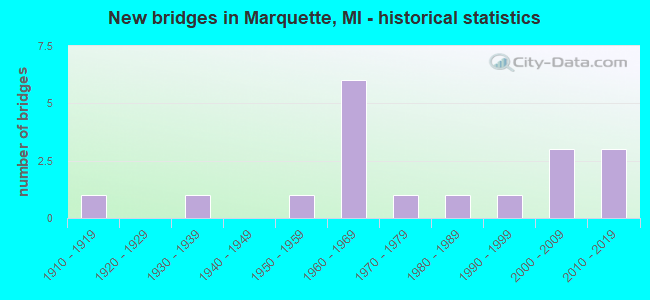
- New bridges - historical statistics
- 11910-1919
- 11930-1939
- 11950-1959
- 61960-1969
- 11970-1979
- 11980-1989
- 11990-1999
- 32000-2009
- 32010-2019
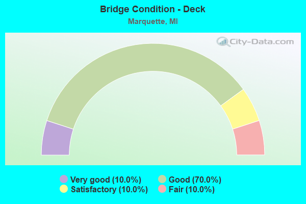
- Bridge Condition - Deck
- 10.0%Very good
- 70.0%Good
- 10.0%Satisfactory
- 10.0%Fair
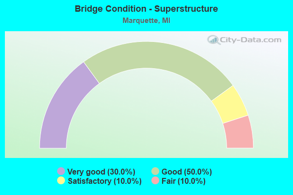
- Bridge Condition - Superstructure
- 30.0%Very good
- 50.0%Good
- 10.0%Satisfactory
- 10.0%Fair
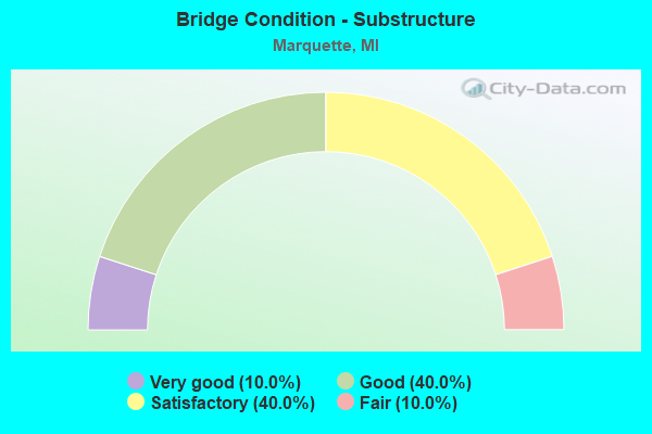
- Bridge Condition - Substructure
- 10.0%Very good
- 40.0%Good
- 40.0%Satisfactory
- 10.0%Fair
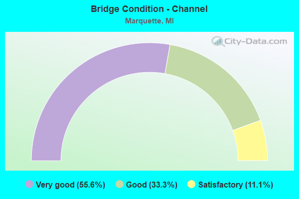
- Bridge Condition - Channel
- 55.6%Very good
- 33.3%Good
- 11.1%Satisfactory
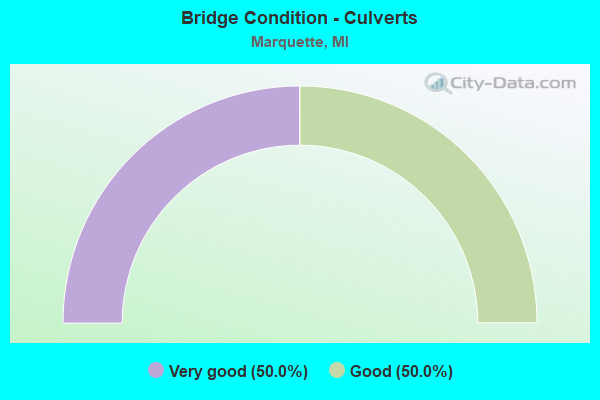
- Bridge Condition - Culverts
- 50.0%Very good
- 50.0%Good
Find on map >> Show street view
Structure Number: 651, Location: 1.0 MI S OF US-10 (Lat: 43.582806, Lng: -84.139425), Route carried "on" structure: County highway 2015, Year Built: 1966, Status: Open, Structure Length: 5.51m (18.08ft), Average Daily Traffic: 2,670 (year 1997), Truck Traffic: 3%, Average Future Daily Traffic: 9,999 (year 1977), Design Load: H 15, Features Intersected: M-47, Facility Carried by Structure: SALZBURG RD
Minimum Vertical Clearance: 30.48m (100.00ft), Kilometerpoint: 2.303, Lanes on structure: 2, Lanes under structure: 4, Owner: State Highway Agency, Approaching Roadway Width: 8.3m (27.2ft), Material/Design: Prestressed concrete, Design/Construction: Stringer/Multi-beam, Number Of Spans In Main Unit: 4, Length of Maximum Span: 18.2m (59.7ft), Curb or Sidewalk Widths: Left: 0.6m (2.0ft), Right: 0.6m (2.0ft), Curb-To-Curb Width: 7.9m (25.9ft), Out-to-Out Width: 9.9m (32.5ft)
Condition: Deck: Fair, Superstructure: Fair, Substructure: Satisfactory, Operating Rating: 55.1 metric tons, Method Used To Determine Operating Rating: Load Factor (LF) rating reported by rating factor (RF) method using MS18 loading, Inventory Rating: 26.2 metric tons, Method Used To Determine Inventory Rating: Load Factor (LF) rating reported by rating factor (RF) method using MS18 loading, Structural Evaluation: Somewhat better than minimum adequacy, Deck Geometry: High priority of corrective action, Underclear: Somewhat better than minimum adequacy, Approach Roadway Alignment: Equal to present minimum criteria, Designated Inspection Frequency: Every 24 months, Inspection Date: Febuary 2021, Deck Structure Type: Concrete Cast-file-Place, Wearing Surface/Protective System: Wearing Surface: Epoxy Overlay
Find on map >> Show street view
Structure Number: 6503, Location: IN MARQUETTE (Lat: 46.518275, Lng: -87.384514), Route carried "on" structure: US 41, Year Built: 1936, Year Reconstructed: 1973, Status: Open, Structure Length: 2.80m (9.19ft), Average Daily Traffic: 23,600 (year 2015), Truck Traffic: 2%, Average Future Daily Traffic: 27,400 (year 2035), Design Load: HS 20, Features Intersected: CARP RIVER
Minimum Vertical Clearance: 30.48m (100.00ft), Kilometerpoint: 35.257, Lanes on structure: 4, Base Highway Network: Yes (Inventory Route: 156, Subroute: 9), Owner: State Highway Agency, Approaching Roadway Width: 11.0m (36.1ft), Material/Design: Steel, Design/Construction: Stringer/Multi-beam, Number Of Spans In Main Unit: 1, Length of Maximum Span: 27.0m (88.6ft), Curb-To-Curb Width: 22.3m (73.2ft), Out-to-Out Width: 23.3m (76.4ft)
Condition: Deck: Good, Superstructure: Satisfactory, Substructure: Satisfactory, Channel: Satisfactory, Operating Rating: 83.6 metric tons, Method Used To Determine Operating Rating: Load Factor (LF) rating reported by rating factor (RF) method using MS18 loading, Inventory Rating: 49.9 metric tons, Method Used To Determine Inventory Rating: Load Factor (LF) rating reported by rating factor (RF) method using MS18 loading, Structural Evaluation: Equal to present minimum criteria, Deck Geometry: Superior to present desirable criteria, Waterway Adequacy: Better than present minimum criteria, Approach Roadway Alignment: Equal to present desirable criteria, Designated Inspection Frequency: Every 24 months, Inspection Date: May 2021, Deck Structure Type: Concrete Cast-file-Place, Wearing Surface/Protective System: Wearing Surface: Monolithic Concrete
Find on map >> Show street view
Structure Number: 6507, Location: IN MARQUETTE (Lat: 46.538653, Lng: -87.403642), Route carried "on" structure: City street , Year Built: 1963, Status: Open, Structure Length: 5.27m (17.29ft), Average Daily Traffic: 1,500 (year 1974), Average Future Daily Traffic: 1,500 (year 1977), Design Load: H 15, Features Intersected: US-41 M-28, Facility Carried by Structure: ALTAMONT ST
Minimum Vertical Clearance: 30.48m (100.00ft), Kilometerpoint: 1.431, Lanes on structure: 2, Lanes under structure: 4, Owner: State Highway Agency, Approaching Roadway Width: 8.5m (27.9ft), Skew: 1 degrees, Material/Design: Steel, Design/Construction: Stringer/Multi-beam, Number Of Spans In Main Unit: 3, Length of Maximum Span: 28.3m (92.8ft), Curb or Sidewalk Widths: Left: 1.5m (4.9ft), Right: 1.5m (4.9ft), Curb-To-Curb Width: 8.5m (27.9ft), Out-to-Out Width: 12.3m (40.4ft)
Condition: Deck: Satisfactory, Superstructure: Good, Substructure: Satisfactory, Operating Rating: 58.6 metric tons, Method Used To Determine Operating Rating: Load Factor (LF) rating reported by rating factor (RF) method using MS18 loading, Inventory Rating: 29.5 metric tons, Method Used To Determine Inventory Rating: Load Factor (LF) rating reported by rating factor (RF) method using MS18 loading, Structural Evaluation: Equal to present minimum criteria, Deck Geometry: Somewhat better than minimum adequacy, Underclear: Somewhat better than minimum adequacy, Approach Roadway Alignment: Equal to present minimum criteria, Designated Inspection Frequency: Every 24 months, Inspection Date: June 2021, Bridge Improvement Cost: $114,000, Deck Structure Type: Concrete Cast-file-Place, Wearing Surface/Protective System: Wearing Surface: Latex Concrete
Find on map >> Show street view
Structure Number: 6508, Location: IN MARQUETTE (Lat: 46.537794, Lng: -87.396092), Route carried "on" structure: City street , Year Built: 1963, Status: Open, Structure Length: 6.07m (19.91ft), Average Daily Traffic: 3,300 (year 2012), Truck Traffic: 3%, Average Future Daily Traffic: 3,800 (year 2032), Design Load: H 15, Features Intersected: US-41 M-28, Facility Carried by Structure: CHAMPION ST
Minimum Vertical Clearance: 30.48m (100.00ft), Kilometerpoint: 0.431, Lanes on structure: 2, Lanes under structure: 4, Owner: State Highway Agency, Approaching Roadway Width: 8.2m (26.9ft), Skew: 1 degrees, Material/Design: Steel, Design/Construction: Stringer/Multi-beam, Number Of Spans In Main Unit: 3, Length of Maximum Span: 29.5m (96.8ft), Curb or Sidewalk Widths: Left: 1.5m (4.9ft), Right: 1.5m (4.9ft), Curb-To-Curb Width: 8.5m (27.9ft), Out-to-Out Width: 12.3m (40.4ft)
Condition: Deck: Good, Superstructure: Good, Substructure: Good, Operating Rating: 64.8 metric tons, Method Used To Determine Operating Rating: Load Factor (LF) rating reported by rating factor (RF) method using MS18 loading, Inventory Rating: 38.9 metric tons, Method Used To Determine Inventory Rating: Load Factor (LF) rating reported by rating factor (RF) method using MS18 loading, Structural Evaluation: Better than present minimum criteria, Deck Geometry: Meets minimum limits, Underclear: Meets minimum limits, Approach Roadway Alignment: Better than present minimum criteria, Designated Inspection Frequency: Every 24 months, Inspection Date: June 2021, Deck Structure Type: Concrete Cast-file-Place, Wearing Surface/Protective System: Wearing Surface: Latex Concrete
Find on map >> Show street view
Structure Number: 6557, Location: IN MARQUETTE (Lat: 46.572003, Lng: -87.409867), Route carried "on" structure: City street 2018, Year Built: 1995, Status: Open, Structure Length: 5.91m (19.39ft), Average Daily Traffic: 2,812 (year 1994), Truck Traffic: 4%, Average Future Daily Traffic: 3,450 (year 2014), Design Load: HS 20, Features Intersected: DEAD RIVER, Facility Carried by Structure: COUNTY ROAD 550
Minimum Vertical Clearance: 30.48m (100.00ft), Kilometerpoint: 1.107, Lanes on structure: 2, Owner: City or Municipal Highway Agency, Approaching Roadway Width: 12.2m (40.0ft), Material/Design: Concrete, Design/Construction: Box Beam or Girders - Multiple, Number Of Spans In Main Unit: 3, Length of Maximum Span: 30.4m (99.7ft), Curb-To-Curb Width: 12.3m (40.4ft), Out-to-Out Width: 12.3m (40.4ft)
Condition: Deck: Good, Superstructure: Good, Substructure: Fair, Channel: Very good, Operating Rating: 70.0 metric tons, Method Used To Determine Operating Rating: Load Factor (LF) rating reported by rating factor (RF) method using MS18 loading, Inventory Rating: 35.0 metric tons, Method Used To Determine Inventory Rating: Load Factor (LF) rating reported by rating factor (RF) method using MS18 loading, Structural Evaluation: Somewhat better than minimum adequacy, Deck Geometry: Equal to present minimum criteria, Waterway Adequacy: Superior to present desirable criteria, Approach Roadway Alignment: Superior to present desirable criteria, Designated Inspection Frequency: Every 24 months, Inspection Date: July 2021, Deck Structure Type: Concrete Precast Panels, Wearing Surface/Protective System: Wearing Surface: Monolithic Concrete, Deck Protection: Epoxy Coated Reinforcing
Find on map >> Show street view
Structure Number: 6558, Location: 1.5 MILES N OF MARQUETTE (Lat: 46.586500, Lng: -87.441556), Route carried "on" structure: County highway 5283, Year Built: 2014, Status: Open, Structure Length: 1.22m (4.00ft), Average Daily Traffic: 1,400 (year 2013), Truck Traffic: 11%, Average Future Daily Traffic: 1,450 (year 2033), Design Load: HS 20+Mod, Features Intersected: COMPEAU CREEK, Facility Carried by Structure: COUNTY ROAD 550
Minimum Vertical Clearance: 30.48m (100.00ft), Kilometerpoint: 4.173, Lanes on structure: 2, Owner: County Highway Agency, Approaching Roadway Width: 12.2m (40.0ft), Material/Design: Prestressed concrete, Design/Construction: Box Beam or Girders - Multiple, Number Of Spans In Main Unit: 1, Length of Maximum Span: 11.8m (38.7ft), Curb-To-Curb Width: 12.4m (40.7ft), Out-to-Out Width: 13.4m (44.0ft)
Condition: Deck: Very good, Superstructure: Very good, Substructure: Very good, Channel: Very good, Operating Rating: 58.0 metric tons, Method Used To Determine Operating Rating: Load and Resistance Factor Rating (LRFR) rating reported by rating factor(RF) method using HL-93 loadings, Inventory Rating: 44.7 metric tons, Method Used To Determine Inventory Rating: Load and Resistance Factor Rating (LRFR) rating reported by rating factor(RF) method using HL-93 loadings, Structural Evaluation: Equal to present desirable criteria, Deck Geometry: Better than present minimum criteria, Waterway Adequacy: Equal to present desirable criteria, Approach Roadway Alignment: Equal to present minimum criteria, Designated Inspection Frequency: Every 24 months, Inspection Date: October 2020, Deck Structure Type: Concrete Cast-file-Place, Wearing Surface/Protective System: Wearing Surface: Monolithic Concrete, Deck Protection: Epoxy Coated Reinforcing
Find on map >> Show street view
Structure Number: 6593, Location: 2 MI N OF JCT US41 CO492 (Lat: 46.573683, Lng: -87.469681), Route carried "on" structure: County highway , Year Built: 2012, Status: Open, Structure Length: 3.05m (10.01ft), Average Daily Traffic: 378 (year 2010), Truck Traffic: 8%, Average Future Daily Traffic: 560 (year 2030), Design Load: HS 20+Mod, Features Intersected: DEAD RIVER, Facility Carried by Structure: HD RD(FORESTVILLE)
Minimum Vertical Clearance: 30.48m (100.00ft), Kilometerpoint: 2.271, Lanes on structure: 2, Owner: County Highway Agency, Approaching Roadway Width: 8.5m (27.9ft), Material/Design: Prestressed concrete, Design/Construction: Box Beam or Girders - Multiple, Number Of Spans In Main Unit: 1, Number Of Approach Spans: 1, Length of Maximum Span: 29.9m (98.1ft), Curb-To-Curb Width: 8.5m (27.9ft), Out-to-Out Width: 8.6m (28.2ft)
Condition: Deck: Good, Superstructure: Very good, Substructure: Good, Channel: Very good, Operating Rating: 58.3 metric tons, Method Used To Determine Operating Rating: Load and Resistance Factor Rating (LRFR) rating reported by rating factor(RF) method using HL-93 loadings, Inventory Rating: 45.0 metric tons, Method Used To Determine Inventory Rating: Load and Resistance Factor Rating (LRFR) rating reported by rating factor(RF) method using HL-93 loadings, Structural Evaluation: Better than present minimum criteria, Deck Geometry: Equal to present minimum criteria, Waterway Adequacy: Equal to present desirable criteria, Approach Roadway Alignment: Equal to present minimum criteria, Designated Inspection Frequency: Every 24 months, Inspection Date: October 2020, Deck Structure Type: Concrete Cast-file-Place, Wearing Surface/Protective System: Wearing Surface: Monolithic Concrete, Deck Protection: Epoxy Coated Reinforcing
Find on map >> Show street view
Structure Number: 6594, Location: 2.0 MI SW OF 550 HWY (Lat: 46.573644, Lng: -87.476647), Route carried "on" structure: County highway , Year Built: 1950, Status: Open, Structure Length: 1.03m (3.38ft), Average Daily Traffic: 30 (year 2001), Average Future Daily Traffic: 30 (year 2020), Design Load: HS 20+Mod, Features Intersected: REANY CREEK, Facility Carried by Structure: HL ROAD
Minimum Vertical Clearance: 30.48m (100.00ft), Kilometerpoint: 2.374, Lanes on structure: 2, Owner: County Highway Agency, Approaching Roadway Width: 8.5m (27.9ft), Material/Design: Steel, Design/Construction: Stringer/Multi-beam, Number Of Spans In Main Unit: 1, Length of Maximum Span: 9.4m (30.8ft), Curb or Sidewalk Widths: Left: 0.3m (1.0ft), Right: 0.3m (1.0ft), Curb-To-Curb Width: 7.0m (23.0ft), Out-to-Out Width: 7.6m (24.9ft)
Condition: Deck: Good, Superstructure: Good, Substructure: Good, Channel: Good, Operating Rating: 97.2 metric tons, Method Used To Determine Operating Rating: Load Factor (LF) rating reported by rating factor (RF) method using MS18 loading, Inventory Rating: 97.2 metric tons, Method Used To Determine Inventory Rating: Load Factor (LF) rating reported by rating factor (RF) method using MS18 loading, Structural Evaluation: Better than present minimum criteria, Deck Geometry: Somewhat better than minimum adequacy, Waterway Adequacy: Better than present minimum criteria, Approach Roadway Alignment: Equal to present minimum criteria, Designated Inspection Frequency: Every 24 months, Inspection Date: October 2020, Deck Structure Type: Concrete Cast-file-Place, Wearing Surface/Protective System: Wearing Surface: Bituminous
Find on map >> Show street view
Structure Number: 661, Location: 3.5 MI N OF CASCADE (Lat: 46.494689, Lng: -87.471058), Route carried "on" structure: County highway , Year Built: 2018, Status: Open, Structure Length: 1.35m (4.43ft), Average Daily Traffic: 210 (year 2016), Truck Traffic: 41%, Average Future Daily Traffic: 250 (year 2036), Design Load: Greater than HL93, Features Intersected: CARP RIVER, Facility Carried by Structure: NP ROAD
Minimum Vertical Clearance: 30.48m (100.00ft), Kilometerpoint: 4.777, Lanes on structure: 2, Owner: County Highway Agency, Approaching Roadway Width: 8.5m (27.9ft), Material/Design: Concrete, Design/Construction: Culvert, Number Of Spans In Main Unit: 1, Length of Maximum Span: 12.9m (42.3ft), Curb-To-Curb Width: 8.5m (27.9ft), Out-to-Out Width: 11.1m (36.4ft)
Condition: Channel: Very good, Culverts: Very good, Operating Rating: 61.6 metric tons, Method Used To Determine Operating Rating: Load and Resistance Factor Rating (LRFR) rating reported by rating factor(RF) method using HL-93 loadings, Inventory Rating: 45.4 metric tons, Method Used To Determine Inventory Rating: Load and Resistance Factor Rating (LRFR) rating reported by rating factor(RF) method using HL-93 loadings, Structural Evaluation: Equal to present desirable criteria, Deck Geometry: Equal to present minimum criteria, Waterway Adequacy: Superior to present desirable criteria, Approach Roadway Alignment: Equal to present minimum criteria, Designated Inspection Frequency: Every 24 months, Inspection Date: October 2020, Wearing Surface/Protective System: Wearing Surface: Bituminous
Find on map >> Show street view
Structure Number: 6624, Location: CITY OF MARQUETTE (Lat: 46.576786, Lng: -87.392856), Route carried "on" structure: City street , Year Built: 1984, Status: Open, Structure Length: 2.80m (9.19ft), Average Daily Traffic: 4,700 (year 1984), Truck Traffic: 1%, Average Future Daily Traffic: 6,000 (year 2008), Design Load: HS 20+Mod, Features Intersected: DEAD RIVER, Facility Carried by Structure: LAKE SHORE BLVD
Minimum Vertical Clearance: 30.48m (100.00ft), Kilometerpoint: 7.472, Lanes on structure: 2, Owner: City or Municipal Highway Agency, Approaching Roadway Width: 10.4m (34.1ft), Material/Design: Prestressed concrete, Design/Construction: Stringer/Multi-beam, Number Of Spans In Main Unit: 1, Length of Maximum Span: 28.0m (91.9ft), Curb or Sidewalk Widths: Left: 2.4m (7.9ft), Right: 1.8m (5.9ft), Curb-To-Curb Width: 10.4m (34.1ft), Out-to-Out Width: 15.2m (49.9ft)
Condition: Deck: Good, Superstructure: Very good, Substructure: Satisfactory, Channel: Good, Operating Rating: 89.1 metric tons, Method Used To Determine Operating Rating: Load Factor (LF) rating reported by rating factor (RF) method using MS18 loading, Inventory Rating: 51.2 metric tons, Method Used To Determine Inventory Rating: Load Factor (LF) rating reported by rating factor (RF) method using MS18 loading, Structural Evaluation: Equal to present minimum criteria, Deck Geometry: Somewhat better than minimum adequacy, Waterway Adequacy: Equal to present desirable criteria, Approach Roadway Alignment: Equal to present desirable criteria, Designated Inspection Frequency: Every 24 months, Inspection Date: July 2021, Deck Structure Type: Concrete Cast-file-Place, Wearing Surface/Protective System: Wearing Surface: Monolithic Concrete, Deck Protection: Epoxy Coated Reinforcing
Find on map >> Show street view
Structure Number: 13102, Location: 0.5 MI S OF M-554 (Lat: 46.509094, Lng: -87.418853), Route carried "on" structure: State highway 553, Year Built: 2002, Status: Open, Structure Length: 2.35m (7.71ft), Average Daily Traffic: 6,595 (year 2007), Average Future Daily Traffic: 7,584 (year 2027), Design Load: HS 25 or greater, Features Intersected: CARP RIVER
Minimum Vertical Clearance: 30.48m (100.00ft), Kilometerpoint: 27.392, Lanes on structure: 2, Owner: State Highway Agency, Approaching Roadway Width: 14.0m (45.9ft), Skew: 3 degrees, Material/Design: Prestressed concrete, Design/Construction: Box Beam or Girders - Multiple, Number Of Spans In Main Unit: 1, Length of Maximum Span: 22.3m (73.2ft), Curb-To-Curb Width: 14.0m (45.9ft), Out-to-Out Width: 15.1m (49.5ft)
Condition: Deck: Good, Superstructure: Good, Substructure: Good, Channel: Very good, Operating Rating: 82.4 metric tons, Method Used To Determine Operating Rating: Load Factor (LF), Inventory Rating: 44.6 metric tons, Method Used To Determine Inventory Rating: Load Factor (LF), Structural Evaluation: Better than present minimum criteria, Deck Geometry: Superior to present desirable criteria, Waterway Adequacy: Equal to present desirable criteria, Approach Roadway Alignment: Equal to present desirable criteria, Designated Inspection Frequency: Every 24 months, Inspection Date: May 2021, Deck Structure Type: Concrete Cast-file-Place, Wearing Surface/Protective System: Wearing Surface: Monolithic Concrete, Deck Protection: Epoxy Coated Reinforcing
Find on map >> Show street view
Structure Number: 13623, Location: 1480 FT S OF BARAGA AVE (Lat: 46.537028, Lng: -87.394556), Route carried "on" structure: City street , Year Built: 2005, Status: Open, Structure Length: 0.78m (2.56ft), Average Daily Traffic: 3,000 (year 2000), Truck Traffic: 3%, Average Future Daily Traffic: 5,000 (year 2030), Design Load: HS 20, Features Intersected: WHETSTONE CREEK, Facility Carried by Structure: LAKE SHORE BLVD
Minimum Vertical Clearance: 30.48m (100.00ft), Kilometerpoint: 0.404, Lanes on structure: 2, Owner: City or Municipal Highway Agency, Approaching Roadway Width: 7.3m (24.0ft), Material/Design: Concrete, Design/Construction: Culvert, Number Of Spans In Main Unit: 1, Length of Maximum Span: 7.3m (24.0ft), Curb or Sidewalk Widths: Left: 1.7m (5.6ft), Right: 1.7m (5.6ft), Curb-To-Curb Width: 6.7m (22.0ft), Out-to-Out Width: 12.2m (40.0ft)
Condition: Channel: Good, Culverts: Good, Operating Rating: 51.8 metric tons, Method Used To Determine Operating Rating: Load and Resistance Factor Rating (LRFR) rating reported by rating factor(RF) method using HL-93 loadings, Inventory Rating: 38.9 metric tons, Method Used To Determine Inventory Rating: Load and Resistance Factor Rating (LRFR) rating reported by rating factor(RF) method using HL-93 loadings, Structural Evaluation: Better than present minimum criteria, Deck Geometry: High priority of replacement, Waterway Adequacy: Equal to present desirable criteria, Approach Roadway Alignment: Better than present minimum criteria, Designated Inspection Frequency: Every 24 months, Inspection Date: July 2021, Wearing Surface/Protective System: Wearing Surface: Bituminous
Find on map >> Show street view
Structure Number: 6507, Location: IN MARQUETTE (Lat: 46.538653, Lng: -87.403642), Route carried "under" structure: US 41, Year Built: 1963, Structure Length: 0. m, Average Daily Traffic: 14,254 (year 2007), Truck Traffic: 2%, Features Intersected: US-41 M-28, Facility Carried by Structure: ALTAMONT ST
Minimum Vertical Clearance: 5.59m (18.34ft), Kilometerpoint: 38.424, Lanes on structure: 2, Lanes under structure: 4, Material/Design: Steel, Design/Construction: Stringer/Multi-beam, Length of Maximum Span: 28.3m (92.8ft)
Find on map >> Show street view
Structure Number: 6508, Location: IN MARQUETTE (Lat: 46.537794, Lng: -87.396092), Route carried "under" structure: US 41, Year Built: 1963, Structure Length: 0. m, Average Daily Traffic: 15,000 (year 2012), Truck Traffic: 5%, Features Intersected: US-41 M-28, Facility Carried by Structure: CHAMPION ST
Minimum Vertical Clearance: 4.62m (15.16ft), Kilometerpoint: 37.832, Lanes on structure: 2, Lanes under structure: 4, Material/Design: Steel, Design/Construction: Stringer/Multi-beam, Length of Maximum Span: 29.5m (96.8ft)
Find on map >> Show street view
Structure Number: 651, Location: IN MARQUETTE (Lat: 46.545231, Lng: -87.426414), Route carried "under" structure: US 41, Year Built: 1963, Structure Length: 0. m, Average Daily Traffic: 16,268 (year 2007), Truck Traffic: 4%, Features Intersected: US-41, Facility Carried by Structure: WCL RR
Minimum Vertical Clearance: 4.85m (15.91ft), Kilometerpoint: 40.388, Lanes under structure: 4, Material/Design: Steel, Design/Construction: Stringer/Multi-beam, Length of Maximum Span: 27.7m (90.9ft)
Find on map >> Show street view
Structure Number: 6628, Location: 3.3 MI N OF E WASHINGTON (Lat: 46.580919, Lng: -87.389833), Route carried "under" structure: City street , Year Built: 1911, Structure Length: 0. m, Average Daily Traffic: 4,700 (year 1977), Features Intersected: LAKESHORE BLVD, Facility Carried by Structure: LS & I RAILROAD
Minimum Vertical Clearance: 6.47m (21.23ft), Kilometerpoint: 7.997, Lanes under structure: 2, Material/Design: Steel, Design/Construction: Box Beam or Girders - Multiple, Length of Maximum Span: 11.5m (37.7ft)
Find on map >> Show street view
Structure Number: 6629, Location: 3.2 MI N OF E WASHINGTON (Lat: 46.579731, Lng: -87.391139), Route carried "under" structure: City street , Year Built: 1976, Structure Length: 0. m, Average Daily Traffic: 4,700 (year 1977), Features Intersected: LAKESHORE BLVD, Facility Carried by Structure: COAL CONVEYOR
Minimum Vertical Clearance: 11.28m (37.01ft), Kilometerpoint: 7.831, Lanes under structure: 2, Material/Design: Steel, Design/Construction: Truss - Deck, Length of Maximum Span: 29.2m (95.8ft)
Find on map >> Show street view
Structure Number: 13418, Location: MARQUETTE (Lat: 46.531250, Lng: -87.417889), Route carried "under" structure: State highway 553, Year Built: 2003, Structure Length: 0. m, Average Daily Traffic: 6,700 (year 2006), Features Intersected: M-553, Facility Carried by Structure: PEDESTRIAN
Minimum Vertical Clearance: 30+ m (98+ ft), Kilometerpoint: 1.691, Lanes under structure: 5, Material/Design: Steel, Design/Construction: Truss - Thru, Length of Maximum Span: 36.0m (118.1ft)