Bridge Statistics for Marrero, Louisiana (LA)
Condition, Traffic, Stress, Structural Evaluation, Project Costs
- National Bridge Inventory (NBI) Statistics
- 35Number of bridges
- 138ft / 41.6mTotal length
- $1,725,000Total costs
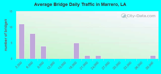
- 245,312Total average daily traffic
- 3,880Total average daily truck traffic
- National Bridge Inventory (NBI) Registered Bridges for Marrero
- No street view available for this location
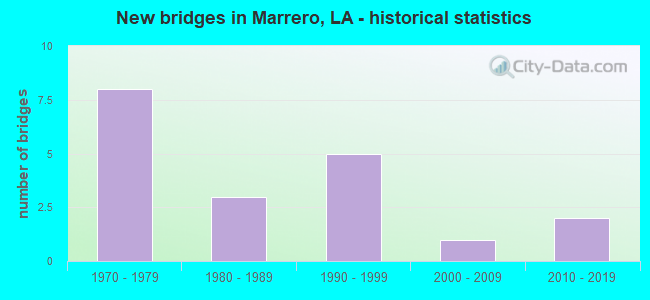
- New bridges - historical statistics
- 81970-1979
- 31980-1989
- 51990-1999
- 12000-2009
- 22010-2019
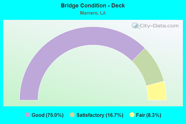
- Bridge Condition - Deck
- 75.0%Good
- 16.7%Satisfactory
- 8.3%Fair
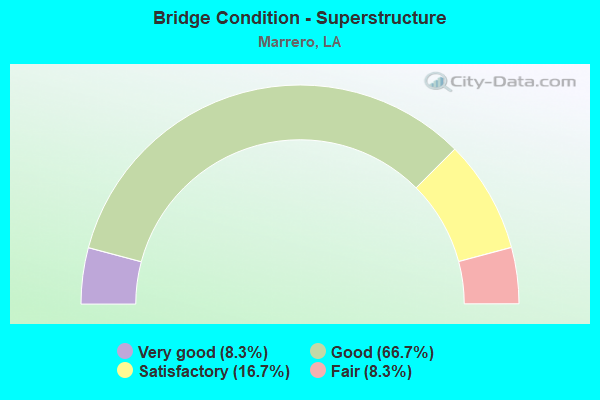
- Bridge Condition - Superstructure
- 8.3%Very good
- 66.7%Good
- 16.7%Satisfactory
- 8.3%Fair
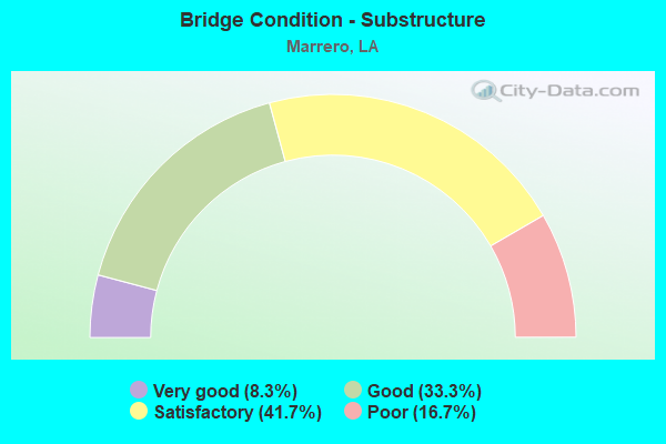
- Bridge Condition - Substructure
- 8.3%Very good
- 33.3%Good
- 41.7%Satisfactory
- 16.7%Poor
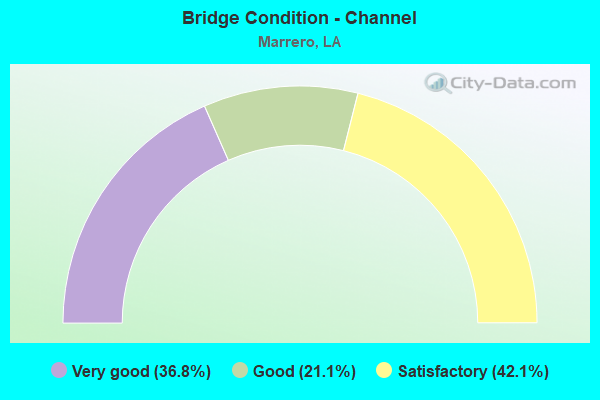
- Bridge Condition - Channel
- 36.8%Very good
- 21.1%Good
- 42.1%Satisfactory
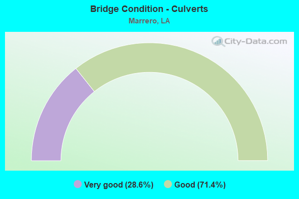
- Bridge Condition - Culverts
- 28.6%Very good
- 71.4%Good
Find on map >> Show street view
Structure Number: 22600000000061, Location: 0.5 MI W OF LA 45 (Lat: 29.871911, Lng: -90.106581), Route carried "on" structure: County highway , Year Built: 2014, Status: Open, Structure Length: 0.73m (2.40ft), Average Daily Traffic: 431 (year 2007), Average Future Daily Traffic: 550 (year 2038), Design Load: HL 93, Features Intersected: DRAINAGE CANAL, Facility Carried by Structure: CANAL RD
Minimum Vertical Clearance: 30+ m (98+ ft), Kilometerpoint: 0.000, Lanes on structure: 2, Owner: County Highway Agency, Approaching Roadway Width: 6.4m (21.0ft), Material/Design: Concrete, Design/Construction: Culvert, Number Of Spans In Main Unit: 1, Length of Maximum Span: 7.3m (24.0ft), Out-to-Out Width: 14.6m (47.9ft)
Condition: Channel: Very good, Culverts: Good, Operating Rating: 38.6 metric tons, Method Used To Determine Operating Rating: Load and Resistance Factor Rating (LRFR) rating reported by rating factor(RF) method using HL-93 loadings, Inventory Rating: 29.8 metric tons, Method Used To Determine Inventory Rating: Load and Resistance Factor Rating (LRFR) rating reported by rating factor(RF) method using HL-93 loadings, Structural Evaluation: Better than present minimum criteria, Waterway Adequacy: Better than present minimum criteria, Approach Roadway Alignment: Equal to present desirable criteria, Designated Inspection Frequency: Every 24 months, Inspection Date: August 2021
Find on map >> Show street view
Structure Number: 22600000000062, Location: 0.5 MI W OF LA 45 (Lat: 29.868561, Lng: -90.106481), Route carried "on" structure: County highway , Year Built: 2013, Status: Open, Structure Length: 0.73m (2.40ft), Average Daily Traffic: 431 (year 2007), Average Future Daily Traffic: 550 (year 2038), Design Load: HL 93, Features Intersected: DRAINAGE CANAL, Facility Carried by Structure: RANDOLPH ST
Minimum Vertical Clearance: 30+ m (98+ ft), Kilometerpoint: 0.000, Lanes on structure: 2, Owner: County Highway Agency, Approaching Roadway Width: 7.9m (25.9ft), Material/Design: Concrete, Design/Construction: Culvert, Number Of Spans In Main Unit: 1, Length of Maximum Span: 7.3m (24.0ft), Curb-To-Curb Width: 14.8m (48.6ft), Out-to-Out Width: 21.9m (71.9ft)
Condition: Channel: Very good, Culverts: Very good, Operating Rating: 38.6 metric tons, Method Used To Determine Operating Rating: Load and Resistance Factor Rating (LRFR) rating reported by rating factor(RF) method using HL-93 loadings, Inventory Rating: 29.8 metric tons, Method Used To Determine Inventory Rating: Load and Resistance Factor Rating (LRFR) rating reported by rating factor(RF) method using HL-93 loadings, Structural Evaluation: Better than present minimum criteria, Deck Geometry: Superior to present desirable criteria, Waterway Adequacy: Better than present minimum criteria, Approach Roadway Alignment: Equal to present desirable criteria, Designated Inspection Frequency: Every 24 months, Inspection Date: August 2021
Find on map >> Show street view
Structure Number: 22600000020414, Location: 6.1 MILES WEST OF MISSISS (Lat: 29.894061, Lng: -90.126700), Route carried "on" structure: Business US 90, Year Built: 1983, Status: Open, Structure Length: 0.79m (2.59ft), Average Daily Traffic: 38,800 (year 2016), Truck Traffic: 10%, Average Future Daily Traffic: 65,960 (year 2036), Design Load: HS 20, Features Intersected: DRAIN CANAL
Minimum Vertical Clearance: 30+ m (98+ ft), Kilometerpoint: 9.728, Lanes on structure: 6, Base Highway Network: Yes (Inventory Route: 283-09-1, Subroute: 10), Owner: State Highway Agency, Approaching Roadway Width: 10.4m (34.1ft), Skew: 30 degrees, Material/Design: Concrete, Design/Construction: Culvert, Number Of Spans In Main Unit: 1, Length of Maximum Span: 7.9m (25.9ft), Curb or Sidewalk Widths: Left: 2.2m (7.2ft), Right: 2.0m (6.6ft), Curb-To-Curb Width: 24.7m (81.0ft), Out-to-Out Width: 93.0m (305.1ft)
Condition: Channel: Good, Culverts: Good, Operating Rating: 28.5 metric tons, Method Used To Determine Operating Rating: Load and Resistance Factor Rating (LRFR) rating reported by rating factor(RF) method using HL-93 loadings, Inventory Rating: 22.0 metric tons, Method Used To Determine Inventory Rating: Load and Resistance Factor Rating (LRFR) rating reported by rating factor(RF) method using HL-93 loadings, Structural Evaluation: Somewhat better than minimum adequacy, Deck Geometry: Somewhat better than minimum adequacy, Waterway Adequacy: Equal to present minimum criteria, Approach Roadway Alignment: Equal to present desirable criteria, Designated Inspection Frequency: Every 24 months, Inspection Date: July 2020, Deck Structure Type: Concrete Cast-file-Place
Find on map >> Show street view
Structure Number: 22602830500331, Location: 2 MI N OF VETERANS BLVD (Lat: 30.019981, Lng: -90.121761), Route carried "on" structure: City street , Year Built: 2005, Status: Open, Structure Length: 6.10m (20.01ft), Average Daily Traffic: 22,600 (year 2009), Average Future Daily Traffic: 38,420 (year 2036), Design Load: HS 20, Features Intersected: 17TH ST. CANAL, Facility Carried by Structure: Hammond HWY
Minimum Vertical Clearance: 30+ m (98+ ft), Kilometerpoint: 0.000, Lanes on structure: 4, Owner: State Highway Agency, Approaching Roadway Width: 9.1m (29.9ft), Skew: 39 degrees, Material/Design: Concrete, Design/Construction: Slab, Number Of Spans In Main Unit: 5, Length of Maximum Span: 12.5m (41.0ft), Curb or Sidewalk Widths: Left: 1.8m (5.9ft), Right: 1.8m (5.9ft), Curb-To-Curb Width: 18.3m (60.0ft), Out-to-Out Width: 24.6m (80.7ft)
Condition: Deck: Good, Superstructure: Good, Substructure: Satisfactory, Channel: Good, Operating Rating: 54.4 metric tons, Method Used To Determine Operating Rating: Load and Resistance Factor Rating (LRFR) rating reported by rating factor(RF) method using HL-93 loadings, Inventory Rating: 39.9 metric tons, Method Used To Determine Inventory Rating: Load and Resistance Factor Rating (LRFR) rating reported by rating factor(RF) method using HL-93 loadings, Structural Evaluation: Equal to present minimum criteria, Deck Geometry: Somewhat better than minimum adequacy, Waterway Adequacy: Equal to present desirable criteria, Approach Roadway Alignment: Equal to present desirable criteria, Designated Inspection Frequency: Every 24 months, Underwater Inspection Frequency: Every 60 months, Inspection Date: May 2021, Underwater Inspection Date: Febuary 2019, Deck Structure Type: Concrete Cast-file-Place, Wearing Surface/Protective System: Wearing Surface: Monolithic Concrete
Find on map >> Show street view
Structure Number: 22629519900671, Location: 0.5MI.SOUTH OF LAPAL (Lat: 29.864800, Lng: -90.112211), Route carried "on" structure: County highway , Year Built: 1970, Status: Open, Structure Length: 1.83m (6.00ft), Average Daily Traffic: 200 (year 1979), Average Future Daily Traffic: 340 (year 2036), Design Load: HS 20, Features Intersected: AMES CANAL NO.1, Facility Carried by Structure: CADDY DR
Minimum Vertical Clearance: 30+ m (98+ ft), Kilometerpoint: 0.000, Lanes on structure: 2, Owner: County Highway Agency, Approaching Roadway Width: 8.5m (27.9ft), Material/Design: Concrete, Design/Construction: Slab, Number Of Spans In Main Unit: 3, Length of Maximum Span: 5.8m (19.0ft), Curb-To-Curb Width: 8.5m (27.9ft), Out-to-Out Width: 10.0m (32.8ft)
Condition: Deck: Satisfactory, Superstructure: Satisfactory, Substructure: Poor, Channel: Good, Operating Rating: 26.2 metric tons, Method Used To Determine Operating Rating: Load and Resistance Factor Rating (LRFR) rating reported by rating factor(RF) method using HL-93 loadings, Inventory Rating: 20.1 metric tons, Method Used To Determine Inventory Rating: Load and Resistance Factor Rating (LRFR) rating reported by rating factor(RF) method using HL-93 loadings, Structural Evaluation: Meets minimum limits, Deck Geometry: Equal to present minimum criteria, Waterway Adequacy: Equal to present minimum criteria, Approach Roadway Alignment: Better than present minimum criteria, Length Of Structure Improvement: 2.56m (8.40ft), Designated Inspection Frequency: Every 24 months, Other Special Inspection Frequency: Every 12 months, Inspection Date: January 2021, Other Special Inspection Date: January 2020, Bridge Improvement Cost: $152,000, Total Project Cost: $228,000 ( Estimate for 2016), Deck Structure Type: Concrete Cast-file-Place, Wearing Surface/Protective System: Wearing Surface: Monolithic Concrete
Find on map >> Show street view
Structure Number: 22629519900691, Location: 0.5MI.SOUTH OF LAPAL (Lat: 29.864531, Lng: -90.115331), Route carried "on" structure: County highway , Year Built: 1970, Status: Open, Structure Length: 1.74m (5.71ft), Design Load: HS 20, Features Intersected: AMES CANAL NO.1, Facility Carried by Structure: SAUVAGE AVE
Minimum Vertical Clearance: 30+ m (98+ ft), Kilometerpoint: 0.000, Lanes on structure: 2, Owner: County Highway Agency, Approaching Roadway Width: 8.5m (27.9ft), Skew: 2 degrees, Material/Design: Concrete, Design/Construction: Slab, Number Of Spans In Main Unit: 3, Length of Maximum Span: 5.8m (19.0ft), Curb or Sidewalk Widths: Left: 0.0m, Right: 0.6m (2.0ft), Curb-To-Curb Width: 8.5m (27.9ft), Out-to-Out Width: 10.0m (32.8ft)
Condition: Deck: Good, Superstructure: Good, Substructure: Poor, Channel: Satisfactory, Operating Rating: 30.5 metric tons, Method Used To Determine Operating Rating: Load and Resistance Factor Rating (LRFR) rating reported by rating factor(RF) method using HL-93 loadings, Inventory Rating: 20.1 metric tons, Method Used To Determine Inventory Rating: Load and Resistance Factor Rating (LRFR) rating reported by rating factor(RF) method using HL-93 loadings, Structural Evaluation: Meets minimum limits, Deck Geometry: Better than present minimum criteria, Waterway Adequacy: Better than present minimum criteria, Approach Roadway Alignment: Equal to present minimum criteria, Designated Inspection Frequency: Every 24 months, Other Special Inspection Frequency: Every 12 months, Inspection Date: January 2021, Other Special Inspection Date: January 2020, Deck Structure Type: Concrete Precast Panels, Wearing Surface/Protective System: Wearing Surface: Bituminous
Find on map >> Show street view
Structure Number: 22629520900641, Location: 0.6M SOUTH OF LAPALCO (Lat: 29.864889, Lng: -90.110769), Route carried "on" structure: County highway , Year Built: 1992, Status: Open, Structure Length: 2.90m (9.51ft), Average Daily Traffic: 15,000 (year 1985), Average Future Daily Traffic: 25,500 (year 2036), Design Load: HS 20, Features Intersected: EIGHTY ARPENT CANAL, Facility Carried by Structure: AMES BLVD
Minimum Vertical Clearance: 30+ m (98+ ft), Kilometerpoint: 0.000, Lanes on structure: 2, Owner: County Highway Agency, Approaching Roadway Width: 7.3m (24.0ft), Material/Design: Concrete, Design/Construction: Slab, Number Of Spans In Main Unit: 5, Length of Maximum Span: 5.8m (19.0ft), Curb or Sidewalk Widths: Left: 0.0m, Right: 1.2m (3.9ft), Curb-To-Curb Width: 8.5m (27.9ft), Out-to-Out Width: 9.4m (30.8ft)
Condition: Deck: Good, Superstructure: Good, Substructure: Good, Channel: Good, Operating Rating: 40.5 metric tons, Method Used To Determine Operating Rating: Load and Resistance Factor Rating (LRFR) rating reported by rating factor(RF) method using HL-93 loadings, Inventory Rating: 31.4 metric tons, Method Used To Determine Inventory Rating: Load and Resistance Factor Rating (LRFR) rating reported by rating factor(RF) method using HL-93 loadings, Structural Evaluation: Better than present minimum criteria, Waterway Adequacy: Equal to present desirable criteria, Approach Roadway Alignment: Somewhat better than minimum adequacy, Designated Inspection Frequency: Every 24 months, Inspection Date: January 2021, Deck Structure Type: Concrete Cast-file-Place
Find on map >> Show street view
Structure Number: 22629520900642, Location: 0.6 MI. SOUTH OF LAPALCO (Lat: 29.864639, Lng: -90.110639), Route carried "on" structure: County highway , Year Built: 1997, Status: Open, Structure Length: 2.90m (9.51ft), Average Daily Traffic: 18,920 (year 1996), Average Future Daily Traffic: 32,164 (year 2036), Design Load: HS 20, Features Intersected: EIGHTY ARPENT CANAL, Facility Carried by Structure: AMES BLVD
Minimum Vertical Clearance: 30+ m (98+ ft), Kilometerpoint: 0.000, Lanes on structure: 2, Owner: County Highway Agency, Approaching Roadway Width: 7.0m (23.0ft), Skew: 20 degrees, Material/Design: Concrete, Design/Construction: Slab, Number Of Spans In Main Unit: 5, Length of Maximum Span: 5.8m (19.0ft), Curb or Sidewalk Widths: Left: 0.0m, Right: 1.2m (3.9ft), Curb-To-Curb Width: 7.9m (25.9ft), Out-to-Out Width: 9.6m (31.5ft)
Condition: Deck: Good, Superstructure: Good, Substructure: Good, Channel: Very good, Operating Rating: 42.1 metric tons, Method Used To Determine Operating Rating: Load and Resistance Factor Rating (LRFR) rating reported by rating factor(RF) method using HL-93 loadings, Inventory Rating: 32.4 metric tons, Method Used To Determine Inventory Rating: Load and Resistance Factor Rating (LRFR) rating reported by rating factor(RF) method using HL-93 loadings, Structural Evaluation: Better than present minimum criteria, Deck Geometry: High priority of replacement, Waterway Adequacy: Equal to present desirable criteria, Approach Roadway Alignment: Equal to present minimum criteria, Length Of Structure Improvement: 3.72m (12.20ft), Designated Inspection Frequency: Every 24 months, Inspection Date: January 2021, Bridge Improvement Cost: $222,000, Total Project Cost: $333,000 ( Estimate for 2016), Deck Structure Type: Concrete Cast-file-Place, Wearing Surface/Protective System: Wearing Surface: Monolithic Concrete
Find on map >> Show street view
Structure Number: 22629525900691, Location: 0.3 MI.W OF AMES BL (Lat: 29.875450, Lng: -90.115289), Route carried "on" structure: County highway , Year Built: 1970, Status: Open, Structure Length: 4.05m (13.29ft), Average Daily Traffic: 2,000 (year 1988), Average Future Daily Traffic: 3,400 (year 2036), Design Load: HS 20, Features Intersected: AMES CANAL, Facility Carried by Structure: LAPALCO BLVD
Minimum Vertical Clearance: 30+ m (98+ ft), Kilometerpoint: 0.000, Lanes on structure: 2, Owner: County Highway Agency, Approaching Roadway Width: 8.2m (26.9ft), Skew: 11 degrees, Material/Design: Concrete, Design/Construction: Slab, Number Of Spans In Main Unit: 7, Length of Maximum Span: 5.8m (19.0ft), Curb or Sidewalk Widths: Left: 0.0m, Right: 0.9m (3.0ft), Curb-To-Curb Width: 8.5m (27.9ft), Out-to-Out Width: 14.1m (46.3ft)
Condition: Deck: Satisfactory, Superstructure: Satisfactory, Substructure: Good, Channel: Satisfactory, Operating Rating: 37.2 metric tons, Method Used To Determine Operating Rating: Allowable Stress (AS), Inventory Rating: 22.7 metric tons, Method Used To Determine Inventory Rating: Allowable Stress (AS), Structural Evaluation: Equal to present minimum criteria, Deck Geometry: High priority of corrective action, Waterway Adequacy: Equal to present minimum criteria, Approach Roadway Alignment: Better than present minimum criteria, Length Of Structure Improvement: 4.97m (16.31ft), Designated Inspection Frequency: Every 24 months, Inspection Date: January 2021, Bridge Improvement Cost: $296,000, Total Project Cost: $444,000 ( Estimate for 2016), Deck Structure Type: Concrete Precast Panels, Wearing Surface/Protective System: Wearing Surface: Bituminous
Find on map >> Show street view
Structure Number: 22629525900692, Location: 0.3 MI.W.OF AMES BL (Lat: 29.875539, Lng: -90.114861), Route carried "on" structure: County highway , Year Built: 1970, Status: Open, Structure Length: 4.05m (13.29ft), Average Daily Traffic: 2,000 (year 1988), Average Future Daily Traffic: 3,400 (year 2036), Design Load: HS 20, Features Intersected: AMES CANAL, Facility Carried by Structure: LAPALCO BLVD
Minimum Vertical Clearance: 30+ m (98+ ft), Kilometerpoint: 0.000, Lanes on structure: 2, Owner: County Highway Agency, Approaching Roadway Width: 8.2m (26.9ft), Skew: 11 degrees, Material/Design: Concrete, Design/Construction: Slab, Number Of Spans In Main Unit: 7, Length of Maximum Span: 5.8m (19.0ft), Curb or Sidewalk Widths: Left: 0.9m (3.0ft), Right: 0.0m, Curb-To-Curb Width: 8.4m (27.6ft), Out-to-Out Width: 14.1m (46.3ft)
Condition: Deck: Good, Superstructure: Good, Substructure: Good, Channel: Satisfactory, Operating Rating: 37.2 metric tons, Method Used To Determine Operating Rating: Allowable Stress (AS), Inventory Rating: 22.7 metric tons, Method Used To Determine Inventory Rating: Allowable Stress (AS), Structural Evaluation: Equal to present minimum criteria, Deck Geometry: High priority of corrective action, Waterway Adequacy: Equal to present minimum criteria, Approach Roadway Alignment: Better than present minimum criteria, Length Of Structure Improvement: 4.97m (16.31ft), Designated Inspection Frequency: Every 24 months, Inspection Date: January 2021, Bridge Improvement Cost: $296,000, Total Project Cost: $444,000 ( Estimate for 2016), Deck Structure Type: Concrete Precast Panels, Wearing Surface/Protective System: Wearing Surface: Monolithic Concrete
Find on map >> Show street view
Structure Number: 22629527900701, Location: 0.2MI.SOUTH OF MONTG (Lat: 29.879339, Lng: -90.117231), Route carried "on" structure: County highway , Year Built: 1970, Status: Open, Structure Length: 1.83m (6.00ft), Average Daily Traffic: 200 (year 1979), Average Future Daily Traffic: 340 (year 2036), Design Load: HS 20, Features Intersected: MAYRONNE CANAL, Facility Carried by Structure: BETTY ST
Minimum Vertical Clearance: 30+ m (98+ ft), Kilometerpoint: 0.000, Lanes on structure: 2, Owner: County Highway Agency, Approaching Roadway Width: 10.7m (35.1ft), Skew: 2 degrees, Material/Design: Concrete, Design/Construction: Slab, Number Of Spans In Main Unit: 3, Length of Maximum Span: 6.4m (21.0ft), Curb or Sidewalk Widths: Left: 0.9m (3.0ft), Right: 0.9m (3.0ft), Curb-To-Curb Width: 8.3m (27.2ft), Out-to-Out Width: 11.1m (36.4ft)
Condition: Deck: Good, Superstructure: Good, Substructure: Satisfactory, Channel: Satisfactory, Operating Rating: 33.7 metric tons, Method Used To Determine Operating Rating: Load and Resistance Factor Rating (LRFR) rating reported by rating factor(RF) method using HL-93 loadings, Inventory Rating: 25.9 metric tons, Method Used To Determine Inventory Rating: Load and Resistance Factor Rating (LRFR) rating reported by rating factor(RF) method using HL-93 loadings, Structural Evaluation: Equal to present minimum criteria, Deck Geometry: Somewhat better than minimum adequacy, Waterway Adequacy: Equal to present minimum criteria, Approach Roadway Alignment: Equal to present minimum criteria, Designated Inspection Frequency: Every 24 months, Inspection Date: January 2021, Deck Structure Type: Concrete Cast-file-Place, Wearing Surface/Protective System: Wearing Surface: Bituminous
Find on map >> Show street view
Structure Number: 22629529900571, Location: 0.2 MI E. OF BARATARIA (Lat: 29.883400, Lng: -90.095331), Route carried "on" structure: County highway , Year Built: 1970, Status: Open, Structure Length: 1.22m (4.00ft), Average Daily Traffic: 250 (year 1980), Average Future Daily Traffic: 425 (year 2036), Design Load: HS 20, Features Intersected: DRAIN CANAL, Facility Carried by Structure: PATRIOT ST
Minimum Vertical Clearance: 30+ m (98+ ft), Kilometerpoint: 0.000, Lanes on structure: 2, Owner: County Highway Agency, Approaching Roadway Width: 7.0m (23.0ft), Material/Design: Steel, Design/Construction: Stringer/Multi-beam, Number Of Spans In Main Unit: 1, Length of Maximum Span: 12.2m (40.0ft), Curb or Sidewalk Widths: Left: 1.2m (3.9ft), Right: 0.0m, Curb-To-Curb Width: 6.5m (21.3ft), Out-to-Out Width: 11.6m (38.1ft)
Condition: Deck: Good, Superstructure: Very good, Substructure: Very good, Channel: Very good, Operating Rating: 56.1 metric tons, Method Used To Determine Operating Rating: Load and Resistance Factor Rating (LRFR) rating reported by rating factor(RF) method using HL-93 loadings, Inventory Rating: 31.1 metric tons, Method Used To Determine Inventory Rating: Load and Resistance Factor Rating (LRFR) rating reported by rating factor(RF) method using HL-93 loadings, Structural Evaluation: Better than present minimum criteria, Deck Geometry: Meets minimum limits, Waterway Adequacy: Equal to present desirable criteria, Approach Roadway Alignment: Equal to present desirable criteria, Designated Inspection Frequency: Every 24 months, Inspection Date: Febuary 2021, Deck Structure Type: Concrete Cast-file-Place, Wearing Surface/Protective System: Wearing Surface: Monolithic Concrete
Find on map >> Show street view
Structure Number: 22629530900481, Location: .7 MI E. OF BARATARIA BLV (Lat: 29.882181, Lng: -90.087561), Route carried "on" structure: County highway , Year Built: 1980, Status: Open, Structure Length: 1.28m (4.20ft), Average Daily Traffic: 800 (year 1980), Average Future Daily Traffic: 1,360 (year 2036), Design Load: HS 20, Features Intersected: PATRIOT STREET CANAL, Facility Carried by Structure: PATRIOT ST X-OVER
Minimum Vertical Clearance: 30+ m (98+ ft), Kilometerpoint: 0.000, Lanes on structure: 2, Owner: County Highway Agency, Approaching Roadway Width: 7.3m (24.0ft), Material/Design: Concrete, Design/Construction: Slab, Number Of Spans In Main Unit: 3, Length of Maximum Span: 4.3m (14.1ft), Curb or Sidewalk Widths: Left: 0.0m, Right: 1.2m (3.9ft), Curb-To-Curb Width: 7.3m (24.0ft), Out-to-Out Width: 9.1m (29.9ft)
Condition: Deck: Fair, Superstructure: Fair, Substructure: Satisfactory, Channel: Very good, Operating Rating: 32.7 metric tons, Method Used To Determine Operating Rating: Load and Resistance Factor Rating (LRFR) rating reported by rating factor(RF) method using HL-93 loadings, Inventory Rating: 25.3 metric tons, Method Used To Determine Inventory Rating: Load and Resistance Factor Rating (LRFR) rating reported by rating factor(RF) method using HL-93 loadings, Structural Evaluation: Somewhat better than minimum adequacy, Deck Geometry: Meets minimum limits, Waterway Adequacy: Equal to present desirable criteria, Approach Roadway Alignment: Somewhat better than minimum adequacy, Designated Inspection Frequency: Every 24 months, Inspection Date: Febuary 2021, Deck Structure Type: Concrete Precast Panels, Wearing Surface/Protective System: Wearing Surface: Monolithic Concrete
Find on map >> Show street view
Structure Number: 22629530900491, Location: 0.9M EAST OF BARATAR (Lat: 29.882631, Lng: -90.091161), Route carried "on" structure: County highway , Year Built: 1970, Status: Open, Structure Length: 3.90m (12.80ft), Average Daily Traffic: 100 (year 1980), Average Future Daily Traffic: 170 (year 2036), Design Load: HS 20, Features Intersected: 16TH ST CANAL, Facility Carried by Structure: Avenue A
Minimum Vertical Clearance: 30+ m (98+ ft), Kilometerpoint: 0.000, Lanes on structure: 2, Owner: County Highway Agency, Approaching Roadway Width: 9.1m (29.9ft), Material/Design: Concrete, Design/Construction: Slab, Number Of Spans In Main Unit: 7, Length of Maximum Span: 6.1m (20.0ft), Curb or Sidewalk Widths: Left: 1.8m (5.9ft), Right: 0.0m, Curb-To-Curb Width: 8.7m (28.5ft), Out-to-Out Width: 12.3m (40.4ft)
Condition: Deck: Good, Superstructure: Good, Substructure: Satisfactory, Channel: Satisfactory, Operating Rating: 37.2 metric tons, Method Used To Determine Operating Rating: Allowable Stress (AS), Inventory Rating: 22.7 metric tons, Method Used To Determine Inventory Rating: Allowable Stress (AS), Structural Evaluation: Equal to present minimum criteria, Deck Geometry: Better than present minimum criteria, Waterway Adequacy: Better than present minimum criteria, Approach Roadway Alignment: Better than present minimum criteria, Designated Inspection Frequency: Every 24 months, Inspection Date: Febuary 2021, Deck Structure Type: Concrete Cast-file-Place, Wearing Surface/Protective System: Wearing Surface: Monolithic Concrete
Find on map >> Show street view
Structure Number: 22629530900501, Location: 0.8M EAST OF BARATAR (Lat: 29.882800, Lng: -90.092581), Route carried "on" structure: County highway , Year Built: 1970, Status: Open, Structure Length: 3.32m (10.89ft), Average Daily Traffic: 100 (year 1980), Average Future Daily Traffic: 170 (year 2036), Design Load: HS 20, Features Intersected: 16 TH ST CANAL, Facility Carried by Structure: JOHN EHRET SCHOOL
Minimum Vertical Clearance: 30+ m (98+ ft), Kilometerpoint: 0.000, Lanes on structure: 2, Owner: County Highway Agency, Approaching Roadway Width: 9.1m (29.9ft), Material/Design: Concrete, Design/Construction: Slab, Number Of Spans In Main Unit: 6, Length of Maximum Span: 6.1m (20.0ft), Curb or Sidewalk Widths: Left: 0.0m, Right: 1.8m (5.9ft), Curb-To-Curb Width: 8.7m (28.5ft), Out-to-Out Width: 12.3m (40.4ft)
Condition: Deck: Good, Superstructure: Good, Substructure: Satisfactory, Channel: Satisfactory, Operating Rating: 37.2 metric tons, Method Used To Determine Operating Rating: Allowable Stress (AS), Inventory Rating: 22.7 metric tons, Method Used To Determine Inventory Rating: Allowable Stress (AS), Structural Evaluation: Equal to present minimum criteria, Deck Geometry: High priority of corrective action, Waterway Adequacy: Better than present minimum criteria, Approach Roadway Alignment: Better than present minimum criteria, Designated Inspection Frequency: Every 24 months, Inspection Date: Febuary 2021, Deck Structure Type: Concrete Cast-file-Place, Wearing Surface/Protective System: Wearing Surface: Monolithic Concrete
Find on map >> Show street view
Structure Number: 22629531900811, Location: 0.2 MI. E. OF VICTORY DR. (Lat: 29.885969, Lng: -90.133539), Route carried "on" structure: County highway , Year Built: 1984, Status: Open, Structure Length: 1.77m (5.81ft), Average Daily Traffic: 2,000 (year 1984), Average Future Daily Traffic: 3,400 (year 2036), Design Load: HS 20, Features Intersected: GRAND CROSS CANAL, Facility Carried by Structure: LAPALCO BLVD
Minimum Vertical Clearance: 30+ m (98+ ft), Kilometerpoint: 0.000, Lanes on structure: 4, Owner: County Highway Agency, Approaching Roadway Width: 7.3m (24.0ft), Skew: 30 degrees, Material/Design: Concrete, Design/Construction: Culvert, Number Of Spans In Main Unit: 4, Length of Maximum Span: 3.7m (12.1ft), Curb-To-Curb Width: 10.7m (35.1ft), Out-to-Out Width: 56.7m (186.0ft)
Condition: Channel: Satisfactory, Culverts: Good, Operating Rating: 42.1 metric tons, Method Used To Determine Operating Rating: Load and Resistance Factor Rating (LRFR) rating reported by rating factor(RF) method using HL-93 loadings, Inventory Rating: 32.4 metric tons, Method Used To Determine Inventory Rating: Load and Resistance Factor Rating (LRFR) rating reported by rating factor(RF) method using HL-93 loadings, Structural Evaluation: Better than present minimum criteria, Deck Geometry: High priority of replacement, Waterway Adequacy: Equal to present desirable criteria, Approach Roadway Alignment: Equal to present desirable criteria, Length Of Structure Improvement: 2.47m (8.10ft), Designated Inspection Frequency: Every 24 months, Inspection Date: January 2021, Bridge Improvement Cost: $184,000, Total Project Cost: $276,000 ( Estimate for 2016), Deck Structure Type: Concrete Cast-file-Place
Find on map >> Show street view
Structure Number: 22629532900561, Location: .35 SOUTH OF W.B. EXPWY (Lat: 29.889419, Lng: -90.095861), Route carried "on" structure: County highway , Year Built: 1990, Status: Open, Structure Length: 0.85m (2.79ft), Design Load: HS 20, Features Intersected: AVENUE D CANAL, Facility Carried by Structure: WICHERS DR
Minimum Vertical Clearance: 30+ m (98+ ft), Kilometerpoint: 0.000, Lanes on structure: 2, Owner: County Highway Agency, Approaching Roadway Width: 14.3m (46.9ft), Material/Design: Concrete, Design/Construction: Culvert, Number Of Spans In Main Unit: 2, Length of Maximum Span: 3.7m (12.1ft), Curb or Sidewalk Widths: Left: 1.2m (3.9ft), Right: 1.2m (3.9ft), Curb-To-Curb Width: 7.6m (24.9ft), Out-to-Out Width: 20.3m (66.6ft)
Condition: Channel: Very good, Culverts: Good, Operating Rating: 44.1 metric tons, Method Used To Determine Operating Rating: Load and Resistance Factor Rating (LRFR) rating reported by rating factor(RF) method using HL-93 loadings, Inventory Rating: 34.0 metric tons, Method Used To Determine Inventory Rating: Load and Resistance Factor Rating (LRFR) rating reported by rating factor(RF) method using HL-93 loadings, Structural Evaluation: Better than present minimum criteria, Deck Geometry: Equal to present minimum criteria, Waterway Adequacy: Better than present minimum criteria, Approach Roadway Alignment: Better than present minimum criteria, Designated Inspection Frequency: Every 24 months, Inspection Date: Febuary 2021, Deck Structure Type: Concrete Cast-file-Place
Find on map >> Show street view
Structure Number: 22629533900571, Location: 0.2 MI EAST OF BARATARIA (Lat: 29.888269, Lng: -90.095769), Route carried "on" structure: County highway , Year Built: 1996, Status: Open, Structure Length: 0.79m (2.59ft), Design Load: HS 20, Features Intersected: AVENUE D CANAL, Facility Carried by Structure: 13TH ST
Minimum Vertical Clearance: 30+ m (98+ ft), Kilometerpoint: 0.000, Lanes on structure: 2, Base Highway Network: Yes, Owner: County Highway Agency, Approaching Roadway Width: 7.3m (24.0ft), Material/Design: Concrete, Design/Construction: Culvert, Number Of Spans In Main Unit: 2, Length of Maximum Span: 4.0m (13.1ft), Curb or Sidewalk Widths: Left: 1.8m (5.9ft), Right: 0.0m, Curb-To-Curb Width: 7.9m (25.9ft), Out-to-Out Width: 19.5m (64.0ft)
Condition: Channel: Very good, Culverts: Very good, Operating Rating: 56.7 metric tons, Method Used To Determine Operating Rating: Load and Resistance Factor Rating (LRFR) rating reported by rating factor(RF) method using HL-93 loadings, Inventory Rating: 43.7 metric tons, Method Used To Determine Inventory Rating: Load and Resistance Factor Rating (LRFR) rating reported by rating factor(RF) method using HL-93 loadings, Structural Evaluation: Equal to present desirable criteria, Deck Geometry: Equal to present minimum criteria, Waterway Adequacy: Equal to present desirable criteria, Approach Roadway Alignment: Equal to present desirable criteria, Designated Inspection Frequency: Every 24 months, Inspection Date: January 2021, Deck Structure Type: Concrete Cast-file-Place
Find on map >> Show street view
Structure Number: 22629534900561, Location: .30 MI SO. OF W.B. EXPWY (Lat: 29.890331, Lng: -90.095961), Route carried "on" structure: County highway , Year Built: 1990, Status: Open, Structure Length: 0.85m (2.79ft), Design Load: HS 20, Features Intersected: AVENUE D CANAL, Facility Carried by Structure: MEDICAL CENTER BLV
Minimum Vertical Clearance: 30+ m (98+ ft), Kilometerpoint: 0.000, Lanes on structure: 2, Owner: County Highway Agency, Approaching Roadway Width: 23.5m (77.1ft), Skew: 30 degrees, Material/Design: Concrete, Design/Construction: Culvert, Number Of Spans In Main Unit: 2, Length of Maximum Span: 3.7m (12.1ft), Curb or Sidewalk Widths: Left: 1.2m (3.9ft), Right: 1.2m (3.9ft), Curb-To-Curb Width: 15.1m (49.5ft), Out-to-Out Width: 32.0m (105.0ft)
Condition: Channel: Satisfactory, Culverts: Good, Operating Rating: 44.4 metric tons, Method Used To Determine Operating Rating: Load and Resistance Factor Rating (LRFR) rating reported by rating factor(RF) method using HL-93 loadings, Inventory Rating: 34.0 metric tons, Method Used To Determine Inventory Rating: Load and Resistance Factor Rating (LRFR) rating reported by rating factor(RF) method using HL-93 loadings, Structural Evaluation: Better than present minimum criteria, Deck Geometry: Superior to present desirable criteria, Waterway Adequacy: Equal to present minimum criteria, Approach Roadway Alignment: Better than present minimum criteria, Designated Inspection Frequency: Every 24 months, Inspection Date: Febuary 2021, Deck Structure Type: Concrete Cast-file-Place
Find on map >> Show street view
Structure Number: 22602830900001, Location: LA 45@US 90B (Lat: 29.894650, Lng: -90.100039), Route carried "under" structure: State highway 45, Structure Length: 0. m, Average Daily Traffic: 17,950 (year 2014), Features Intersected: LA 45 NB UNDER US 90B WB
Minimum Vertical Clearance: 7.25m (23.79ft), Kilometerpoint: 20.189, Lanes on structure: 3, Lanes under structure: 4, Length of Maximum Span: 0.0m
Find on map >> Show street view
Structure Number: 22602830900001, Location: 0.1 MI W OF LA 45 (Lat: 29.895100, Lng: -90.097569), Route carried "under" structure: ServiceUS 90, Structure Length: 0. m, Average Daily Traffic: 6,600 (year 2015), Features Intersected: US 90B WB SERVICE RD EXI
Minimum Vertical Clearance: 7.35m (24.11ft), Kilometerpoint: 0.072, Lanes on structure: 3, Lanes under structure: 1, Length of Maximum Span: 0.0m
Find on map >> Show street view
Structure Number: 22602830900001, Location: 0.05 MI E OF LA 45 (Lat: 29.894839, Lng: -90.098500), Route carried "under" structure: ServiceUS 90, Structure Length: 0. m, Average Daily Traffic: 6,600 (year 2015), Features Intersected: US 90B EB SERVICE RD EXI
Minimum Vertical Clearance: 7.35m (24.11ft), Kilometerpoint: 0.053, Lanes on structure: 3, Lanes under structure: 1, Length of Maximum Span: 0.0m
Find on map >> Show street view
Structure Number: 22602830900001, Location: LA 45@US 90B (Lat: 29.894781, Lng: -90.100219), Route carried "under" structure: State highway 45, Structure Length: 0. m, Average Daily Traffic: 17,950 (year 2014), Features Intersected: LA 45 SB UNDER US 90B WB
Minimum Vertical Clearance: 7.29m (23.92ft), Kilometerpoint: 0.467, Lanes on structure: 3, Lanes under structure: 5, Length of Maximum Span: 0.0m
Find on map >> Show street view
Structure Number: 22602830900001, Location: 0.25 MI W OF LA 45 (Lat: 29.894361, Lng: -90.104369), Route carried "under" structure: ServiceUS 90, Structure Length: 0. m, Average Daily Traffic: 5,410 (year 2015), Features Intersected: US 90B WB SERVICE RD EXI
Minimum Vertical Clearance: 7.22m (23.69ft), Kilometerpoint: 0.076, Lanes on structure: 3, Lanes under structure: 1, Length of Maximum Span: 0.0m
Find on map >> Show street view
Structure Number: 22602830900001, Location: 0.26 MI W OF LA 45 (Lat: 29.894161, Lng: -90.104650), Route carried "under" structure: ServiceUS 90, Structure Length: 0. m, Average Daily Traffic: 5,410 (year 2015), Features Intersected: US 90B EB SERVICE RD EXI
Minimum Vertical Clearance: 7.44m (24.41ft), Kilometerpoint: 0.055, Lanes on structure: 3, Lanes under structure: 1, Length of Maximum Span: 0.0m
Find on map >> Show street view
Structure Number: 22602830900001, Location: 0.4 MI SW OF LA 18 (Lat: 29.893881, Lng: -90.114189), Route carried "under" structure: ServiceUS 90, Structure Length: 0. m, Average Daily Traffic: 5,410 (year 2015), Features Intersected: US 90B EB SERVICE RD EXI
Minimum Vertical Clearance: 4.66m (15.29ft), Kilometerpoint: 0.051, Lanes on structure: 3, Lanes under structure: 1, Length of Maximum Span: 0.0m
Find on map >> Show street view
Structure Number: 22602830900002, Location: 14.25 MI E OF LA 3060 (Lat: 29.893661, Lng: -90.114239), Route carried "under" structure: ServiceUS 90, Structure Length: 0. m, Average Daily Traffic: 5,410 (year 2015), Features Intersected: US 90B EB SERVICE RD EXI
Minimum Vertical Clearance: 4.60m (15.09ft), Kilometerpoint: 0.027, Lanes on structure: 3, Lanes under structure: 1, Length of Maximum Span: 0.0m
Find on map >> Show street view
Structure Number: 22602830900002, Location: 0.26 MI W OF LA 45 (Lat: 29.893939, Lng: -90.104719), Route carried "under" structure: ServiceUS 90, Structure Length: 0. m, Average Daily Traffic: 5,410 (year 2015), Features Intersected: US 90B EB SERVICE RD EXI
Minimum Vertical Clearance: 7.99m (26.21ft), Kilometerpoint: 0.032, Lanes on structure: 3, Lanes under structure: 1, Length of Maximum Span: 0.0m
Find on map >> Show street view
Structure Number: 22602830900002, Location: 0.25 MI W OF LA 45 (Lat: 29.893950, Lng: -90.104411), Route carried "under" structure: ServiceUS 90, Structure Length: 0. m, Average Daily Traffic: 5,410 (year 2015), Features Intersected: US 90B WB SERVICE RD EXI
Minimum Vertical Clearance: 7.93m (26.02ft), Kilometerpoint: 0.027, Lanes on structure: 3, Lanes under structure: 1, Length of Maximum Span: 0.0m
Find on map >> Show street view
Structure Number: 22602830900002, Location: LA 45@US 90B (Lat: 29.894550, Lng: -90.100200), Route carried "under" structure: State highway 45, Structure Length: 0. m, Average Daily Traffic: 17,950 (year 2014), Features Intersected: LA 45 SB UNDER US 90B EB
Minimum Vertical Clearance: 7.25m (23.79ft), Kilometerpoint: 0.491, Lanes on structure: 3, Lanes under structure: 5, Length of Maximum Span: 0.0m
Find on map >> Show street view
Structure Number: 22602830900002, Location: 0.05 MI E OF LA 45 (Lat: 29.894619, Lng: -90.098519), Route carried "under" structure: ServiceUS 90, Structure Length: 0. m, Average Daily Traffic: 6,600 (year 2015), Features Intersected: US 90B EB SERVICE RD EXI
Minimum Vertical Clearance: 7.44m (24.41ft), Kilometerpoint: 0.027, Lanes on structure: 3, Lanes under structure: 1, Length of Maximum Span: 0.0m
Find on map >> Show street view
Structure Number: 22602830900002, Location: 0.1 MI W OF LA 45 (Lat: 29.894881, Lng: -90.097611), Route carried "under" structure: ServiceUS 90, Structure Length: 0. m, Average Daily Traffic: 6,600 (year 2015), Features Intersected: US 90B WB SERVICE RD EXI
Minimum Vertical Clearance: 7.47m (24.51ft), Kilometerpoint: 0.045, Lanes on structure: 3, Lanes under structure: 1, Length of Maximum Span: 0.0m
Find on map >> Show street view
Structure Number: 22602830900002, Location: LA 45@US 90B (Lat: 29.894431, Lng: -90.100031), Route carried "under" structure: State highway 45, Structure Length: 0. m, Average Daily Traffic: 17,950 (year 2014), Features Intersected: LA 45 NB UNDER US 90B EB
Minimum Vertical Clearance: 7.25m (23.79ft), Kilometerpoint: 20.165, Lanes on structure: 3, Lanes under structure: 4, Length of Maximum Span: 0.0m
Find on map >> Show street view
Structure Number: 22602830904708, Location: 0.25 MI W OF LA 45 (Lat: 29.893939, Lng: -90.104381), Route carried "under" structure: ServiceUS 90, Structure Length: 0. m, Average Daily Traffic: 5,410 (year 2015), Features Intersected: US90B WB SERVICE RD EXIT
Minimum Vertical Clearance: 6.25m (20.51ft), Kilometerpoint: 0.024, Lanes on structure: 1, Lanes under structure: 1, Length of Maximum Span: 0.0m
Find on map >> Show street view
Structure Number: 22602830904708, Location: 0.26 MI W OF LA 45 (Lat: 29.893850, Lng: -90.104811), Route carried "under" structure: ServiceUS 90, Structure Length: 0. m, Average Daily Traffic: 5,410 (year 2015), Features Intersected: US 90B EB SERVICE RD EXI
Minimum Vertical Clearance: 7.80m (25.59ft), Kilometerpoint: 0.019, Lanes on structure: 1, Lanes under structure: 1, Length of Maximum Span: 0.0m