Bridge Statistics for Marshall, Michigan (MI)
Condition, Traffic, Stress, Structural Evaluation, Project Costs
- National Bridge Inventory (NBI) Statistics
- 43Number of bridges
- 390ft / 119mTotal length
- $1,143,000Total costs
- 739,781Total average daily traffic
- 171,122Total average daily truck traffic
- National Bridge Inventory (NBI) Registered Bridges for Marshall
- No street view available for this location
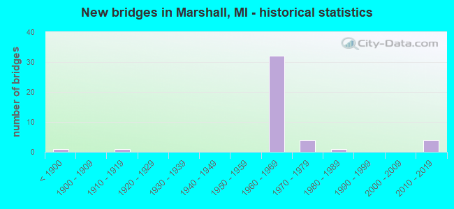
- New bridges - historical statistics
- 1Before 1900
- 11910-1919
- 321960-1969
- 41970-1979
- 11980-1989
- 42010-2019
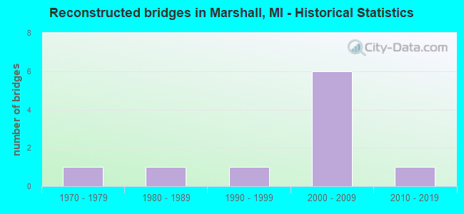
- Reconstructed bridges - Historical Statistics
- 11970-1979
- 11980-1989
- 11990-1999
- 62000-2009
- 12010-2019
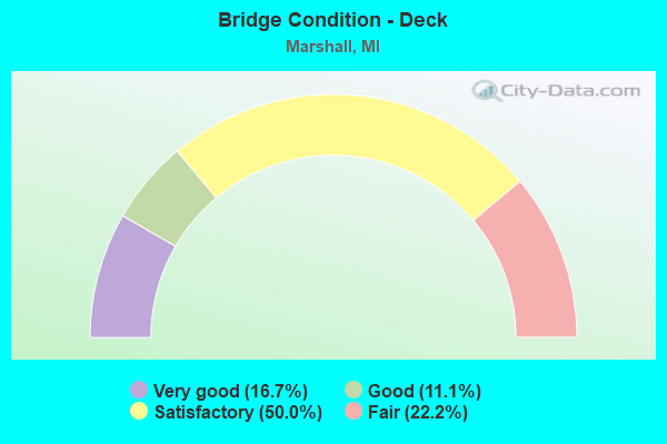
- Bridge Condition - Deck
- 16.7%Very good
- 11.1%Good
- 50.0%Satisfactory
- 22.2%Fair
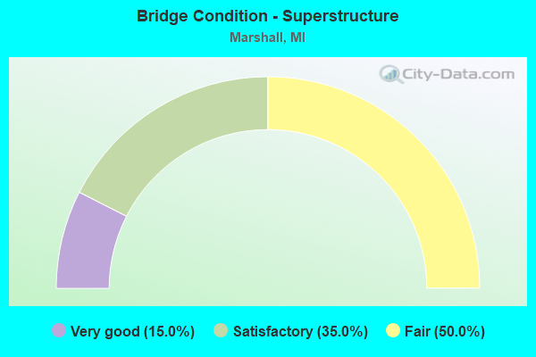
- Bridge Condition - Superstructure
- 15.0%Very good
- 35.0%Satisfactory
- 50.0%Fair
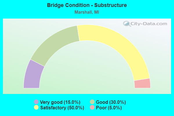
- Bridge Condition - Substructure
- 15.0%Very good
- 30.0%Good
- 50.0%Satisfactory
- 5.0%Poor
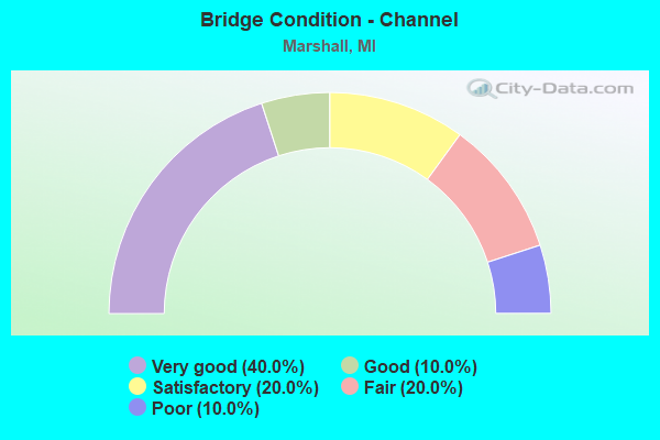
- Bridge Condition - Channel
- 40.0%Very good
- 10.0%Good
- 20.0%Satisfactory
- 20.0%Fair
- 10.0%Poor
Find on map >> Show street view
Structure Number: 1227, Location: 7.5 MI N OF BRANCH COL (Lat: 42.173447, Lng: -84.985150), Route carried "on" structure: County highway , Year Built: 1968, Year Reconstructed: 2010, Status: Open, Structure Length: 4.60m (15.09ft), Truck Traffic: 3%, Average Future Daily Traffic: 564 (year 2030), Design Load: H 15, Features Intersected: I-69 SB, Facility Carried by Structure: J DRIVE S
Minimum Vertical Clearance: 30.48m (100.00ft), Kilometerpoint: 6.108, Lanes on structure: 2, Lanes under structure: 2, Owner: State Highway Agency, Approaching Roadway Width: 6.7m (22.0ft), Skew: 2 degrees, Material/Design: Steel, Design/Construction: Stringer/Multi-beam, Number Of Spans In Main Unit: 3, Length of Maximum Span: 21.7m (71.2ft), Curb-To-Curb Width: 9.8m (32.2ft), Out-to-Out Width: 10.5m (34.4ft)
Condition: Deck: Good, Superstructure: Fair, Substructure: Good, Operating Rating: 58.0 metric tons, Method Used To Determine Operating Rating: Load Factor (LF), Inventory Rating: 34.8 metric tons, Method Used To Determine Inventory Rating: Load Factor (LF), Structural Evaluation: Somewhat better than minimum adequacy, Deck Geometry: Equal to present desirable criteria, Underclear: Somewhat better than minimum adequacy, Approach Roadway Alignment: Equal to present desirable criteria, Designated Inspection Frequency: Every 24 months, Inspection Date: June 2021, Deck Structure Type: Concrete Cast-file-Place, Wearing Surface/Protective System: Wearing Surface: Monolithic Concrete, Deck Protection: Epoxy Coated Reinforcing
Find on map >> Show street view
Structure Number: 1228, Location: 9.5 MI N OF BRANCH COL (Lat: 42.203147, Lng: -84.982064), Route carried "on" structure: State highway 227, Year Built: 1968, Status: Open, Structure Length: 11.98m (39.30ft), Average Daily Traffic: 1,902 (year 2007), Truck Traffic: 11%, Average Future Daily Traffic: 2,689 (year 2018), Design Load: H 15, Features Intersected: I-69
Minimum Vertical Clearance: 30.48m (100.00ft), Kilometerpoint: 0.418, Lanes on structure: 2, Lanes under structure: 4, Owner: State Highway Agency, Approaching Roadway Width: 9.4m (30.8ft), Material/Design: Steel, Design/Construction: Stringer/Multi-beam, Number Of Spans In Main Unit: 5, Length of Maximum Span: 27.7m (90.9ft), Curb-To-Curb Width: 8.7m (28.5ft), Out-to-Out Width: 9.8m (32.2ft)
Condition: Deck: Satisfactory, Superstructure: Fair, Substructure: Satisfactory, Operating Rating: 61.6 metric tons, Method Used To Determine Operating Rating: Load Factor (LF) rating reported by rating factor (RF) method using MS18 loading, Inventory Rating: 36.9 metric tons, Method Used To Determine Inventory Rating: Load Factor (LF) rating reported by rating factor (RF) method using MS18 loading, Structural Evaluation: Somewhat better than minimum adequacy, Deck Geometry: Somewhat better than minimum adequacy, Underclear: Somewhat better than minimum adequacy, Approach Roadway Alignment: Equal to present desirable criteria, Designated Inspection Frequency: Every 24 months, Inspection Date: June 2021, Deck Structure Type: Concrete Cast-file-Place, Wearing Surface/Protective System: Wearing Surface: Latex Concrete
Find on map >> Show street view
Structure Number: 1229, Location: 3.0 MI S OF I-94 (Lat: 42.257403, Lng: -84.987017), Route carried "on" structure: County highway 1358, Year Built: 1968, Year Reconstructed: 2006, Status: Open, Structure Length: 8.73m (28.64ft), Average Daily Traffic: 1,500 (year 1988), Truck Traffic: 3%, Average Future Daily Traffic: 2,040 (year 2000), Design Load: H 20, Features Intersected: I-69, Facility Carried by Structure: A DRIVE N
Minimum Vertical Clearance: 30.48m (100.00ft), Kilometerpoint: 6.270, Lanes on structure: 2, Lanes under structure: 4, Owner: State Highway Agency, Approaching Roadway Width: 7.6m (24.9ft), Material/Design: Steel, Design/Construction: Stringer/Multi-beam, Number Of Spans In Main Unit: 4, Length of Maximum Span: 25.7m (84.3ft), Curb-To-Curb Width: 8.5m (27.9ft), Out-to-Out Width: 10.5m (34.4ft)
Condition: Deck: Satisfactory, Superstructure: Fair, Substructure: Satisfactory, Operating Rating: 64.1 metric tons, Method Used To Determine Operating Rating: Load Factor (LF), Inventory Rating: 38.4 metric tons, Method Used To Determine Inventory Rating: Load Factor (LF), Structural Evaluation: Somewhat better than minimum adequacy, Deck Geometry: Somewhat better than minimum adequacy, Underclear: Somewhat better than minimum adequacy, Approach Roadway Alignment: Equal to present desirable criteria, Designated Inspection Frequency: Every 24 months, Inspection Date: June 2021, Deck Structure Type: Concrete Cast-file-Place, Wearing Surface/Protective System: Wearing Surface: Latex Concrete
Find on map >> Show street view
Structure Number: 123, Location: 2.0 MI S OF I-94 (Lat: 42.269953, Lng: -84.990575), Route carried "on" structure: Business Interstate 94, Year Built: 1968, Year Reconstructed: 2006, Status: Open, Structure Length: 8.54m (28.02ft), Average Daily Traffic: 18,636 (year 2015), Truck Traffic: 2%, Average Future Daily Traffic: 21,925 (year 2035), Design Load: HS 20+Mod, Features Intersected: I-69
Minimum Vertical Clearance: 30.48m (100.00ft), Kilometerpoint: 16.926, Lanes on structure: 2, Lanes under structure: 4, Base Highway Network: Yes (Inventory Route: 313, Subroute: 75), Owner: State Highway Agency, Approaching Roadway Width: 11.1m (36.4ft), Material/Design: Steel, Design/Construction: Stringer/Multi-beam, Number Of Spans In Main Unit: 4, Length of Maximum Span: 25.5m (83.7ft), Curb-To-Curb Width: 9.6m (31.5ft), Out-to-Out Width: 10.6m (34.8ft)
Condition: Deck: Satisfactory, Superstructure: Fair, Substructure: Good, Operating Rating: 68.0 metric tons, Method Used To Determine Operating Rating: Load Factor (LF) rating reported by rating factor (RF) method using MS18 loading, Inventory Rating: 40.8 metric tons, Method Used To Determine Inventory Rating: Load Factor (LF) rating reported by rating factor (RF) method using MS18 loading, Structural Evaluation: Somewhat better than minimum adequacy, Deck Geometry: Meets minimum limits, Underclear: Somewhat better than minimum adequacy, Approach Roadway Alignment: Equal to present desirable criteria, Designated Inspection Frequency: Every 24 months, Inspection Date: June 2021, Deck Structure Type: Concrete Cast-file-Place, Wearing Surface/Protective System: Wearing Surface: Latex Concrete
Find on map >> Show street view
Structure Number: 1236, Location: @ I-94 (Lat: 42.297611, Lng: -84.996472), Route carried "on" structure: Interstate 69, Year Built: 1968, Year Reconstructed: 2006, Status: Open, Structure Length: 10.85m (35.60ft), Average Daily Traffic: 12,184 (year 2007), Truck Traffic: 34%, Average Future Daily Traffic: 25,600 (year 2027), Design Load: HS 20+Mod, Features Intersected: I-94
Minimum Vertical Clearance: 30.48m (100.00ft), Kilometerpoint: 25.932, Lanes on structure: 2, Lanes under structure: 8, Base Highway Network: Yes (Inventory Route: 129, Subroute: 2), Owner: State Highway Agency, Approaching Roadway Width: 11.6m (38.1ft), Material/Design: Steel, Design/Construction: Stringer/Multi-beam, Number Of Spans In Main Unit: 4, Length of Maximum Span: 28.3m (92.8ft), Curb-To-Curb Width: 9.6m (31.5ft), Out-to-Out Width: 10.6m (34.8ft)
Condition: Deck: Satisfactory, Superstructure: Satisfactory, Substructure: Satisfactory, Operating Rating: 59.9 metric tons, Method Used To Determine Operating Rating: Load Factor (LF) rating reported by rating factor (RF) method using MS18 loading, Inventory Rating: 36.0 metric tons, Method Used To Determine Inventory Rating: Load Factor (LF) rating reported by rating factor (RF) method using MS18 loading, Structural Evaluation: Equal to present minimum criteria, Deck Geometry: Meets minimum limits, Underclear: Equal to present minimum criteria, Approach Roadway Alignment: Equal to present desirable criteria, Designated Inspection Frequency: Every 24 months, Inspection Date: June 2021, Deck Structure Type: Concrete Cast-file-Place, Wearing Surface/Protective System: Wearing Surface: Latex Concrete
Find on map >> Show street view
Structure Number: 127, Location: 2.6 MI E OF I-94 BL (Lat: 42.297444, Lng: -85.032544), Route carried "on" structure: County highway 1370, Year Built: 1960, Year Reconstructed: 2007, Status: Open, Structure Length: 12.62m (41.40ft), Average Daily Traffic: 3,000 (year 2008), Truck Traffic: 2%, Average Future Daily Traffic: 3,450 (year 2028), Design Load: H 20, Features Intersected: I-94, Facility Carried by Structure: VERONA ROAD
Minimum Vertical Clearance: 30.48m (100.00ft), Kilometerpoint: 14.079, Lanes on structure: 2, Lanes under structure: 4, Owner: State Highway Agency, Approaching Roadway Width: 7.6m (24.9ft), Skew: 5 degrees, Material/Design: Concrete continuous, Design/Construction: Tee Beam, Number Of Spans In Main Unit: 4, Length of Maximum Span: 39.3m (128.9ft), Curb-To-Curb Width: 9.1m (29.9ft), Out-to-Out Width: 10.2m (33.5ft)
Condition: Deck: Fair, Superstructure: Satisfactory, Substructure: Satisfactory, Operating Rating: 56.7 metric tons, Method Used To Determine Operating Rating: Load Factor (LF) rating reported by rating factor (RF) method using MS18 loading, Inventory Rating: 34.0 metric tons, Method Used To Determine Inventory Rating: Load Factor (LF) rating reported by rating factor (RF) method using MS18 loading, Structural Evaluation: Equal to present minimum criteria, Deck Geometry: Meets minimum limits, Underclear: Meets minimum limits, Approach Roadway Alignment: Equal to present desirable criteria, Designated Inspection Frequency: Every 24 months, Inspection Date: August 2021, Deck Structure Type: Concrete Cast-file-Place, Wearing Surface/Protective System: Wearing Surface: Latex Concrete
Find on map >> Show street view
Structure Number: 1271, Location: 0.4 MI W OF I-69 (Lat: 42.297239, Lng: -85.003750), Route carried "on" structure: County highway , Year Built: 1960, Status: Open, Structure Length: 7.25m (23.79ft), Average Daily Traffic: 955 (year 1997), Truck Traffic: 3%, Average Future Daily Traffic: 1,041 (year 2000), Design Load: H 15, Features Intersected: I-94, Facility Carried by Structure: 15 MILE ROAD
Minimum Vertical Clearance: 30.48m (100.00ft), Kilometerpoint: 3.198, Lanes on structure: 2, Lanes under structure: 6, Owner: State Highway Agency, Approaching Roadway Width: 6.9m (22.6ft), Material/Design: Concrete continuous, Design/Construction: Tee Beam, Number Of Spans In Main Unit: 4, Length of Maximum Span: 21.6m (70.9ft), Curb-To-Curb Width: 9.2m (30.2ft), Out-to-Out Width: 10.0m (32.8ft)
Condition: Deck: Satisfactory, Superstructure: Fair, Substructure: Satisfactory, Operating Rating: 35.3 metric tons, Method Used To Determine Operating Rating: Load and Resistance Factor Rating (LRFR) rating reported by rating factor(RF) method using HL-93 loadings, Inventory Rating: 27.2 metric tons, Method Used To Determine Inventory Rating: Load and Resistance Factor Rating (LRFR) rating reported by rating factor(RF) method using HL-93 loadings, Structural Evaluation: Somewhat better than minimum adequacy, Deck Geometry: Equal to present minimum criteria, Underclear: High priority of corrective action, Approach Roadway Alignment: Equal to present desirable criteria, Designated Inspection Frequency: Every 24 months, Inspection Date: August 2021, Deck Structure Type: Concrete Cast-file-Place, Wearing Surface/Protective System: Wearing Surface: Epoxy Overlay
Find on map >> Show street view
Structure Number: 1274, Location: 4.0 MI E OF I-69 (Lat: 42.282611, Lng: -84.924092), Route carried "on" structure: Interstate 94, Year Built: 1960, Year Reconstructed: 2007, Status: Open, Structure Length: 2.65m (8.69ft), Average Daily Traffic: 17,050 (year 2015), Truck Traffic: 19%, Average Future Daily Traffic: 19,608 (year 2035), Design Load: HS 20, Features Intersected: RICE CREEK
Minimum Vertical Clearance: 30.48m (100.00ft), Kilometerpoint: 32.557, Lanes on structure: 2, Base Highway Network: Yes (Inventory Route: 129, Subroute: 9), Owner: State Highway Agency, Approaching Roadway Width: 12.8m (42.0ft), Skew: 1 degrees, Material/Design: Concrete, Design/Construction: Tee Beam, Number Of Spans In Main Unit: 3, Length of Maximum Span: 8.8m (28.9ft), Curb-To-Curb Width: 13.4m (44.0ft), Out-to-Out Width: 14.4m (47.2ft)
Condition: Deck: Fair, Superstructure: Fair, Substructure: Good, Channel: Fair, Operating Rating: 61.9 metric tons, Method Used To Determine Operating Rating: Load Factor (LF) rating reported by rating factor (RF) method using MS18 loading, Inventory Rating: 37.3 metric tons, Method Used To Determine Inventory Rating: Load Factor (LF) rating reported by rating factor (RF) method using MS18 loading, Structural Evaluation: Somewhat better than minimum adequacy, Deck Geometry: Superior to present desirable criteria, Waterway Adequacy: Better than present minimum criteria, Approach Roadway Alignment: Equal to present desirable criteria, Designated Inspection Frequency: Every 24 months, Inspection Date: September 2021, Deck Structure Type: Concrete Cast-file-Place, Wearing Surface/Protective System: Wearing Surface: Latex Concrete
Find on map >> Show street view
Structure Number: 1275, Location: 1.7 MI E OF I-69 (Lat: 42.294106, Lng: -84.964536), Route carried "on" structure: County highway 1359, Year Built: 1960, Year Reconstructed: 1992, Status: Open, Structure Length: 9.60m (31.50ft), Average Daily Traffic: 13,254 (year 1995), Truck Traffic: 3%, Average Future Daily Traffic: 15,242 (year 2000), Design Load: HS 20, Features Intersected: I-94, Facility Carried by Structure: 17 MILE ROAD
Minimum Vertical Clearance: 30.48m (100.00ft), Kilometerpoint: 25.129, Lanes on structure: 4, Lanes under structure: 5, Owner: State Highway Agency, Approaching Roadway Width: 19.5m (64.0ft), Skew: 3 degrees, Material/Design: Steel, Design/Construction: Stringer/Multi-beam, Number Of Spans In Main Unit: 4, Length of Maximum Span: 30.4m (99.7ft), Curb-To-Curb Width: 17.8m (58.4ft), Out-to-Out Width: 18.7m (61.4ft)
Condition: Deck: Satisfactory, Superstructure: Fair, Substructure: Poor, Operating Rating: 59.6 metric tons, Method Used To Determine Operating Rating: Load Factor (LF) rating reported by rating factor (RF) method using MS18 loading, Inventory Rating: 35.6 metric tons, Method Used To Determine Inventory Rating: Load Factor (LF) rating reported by rating factor (RF) method using MS18 loading, Structural Evaluation: Meets minimum limits, Deck Geometry: Somewhat better than minimum adequacy, Underclear: Meets minimum limits, Approach Roadway Alignment: Equal to present desirable criteria, Designated Inspection Frequency: Every 24 months, Other Special Inspection Frequency: Every 24 months, Inspection Date: August 2021, Other Special Inspection Date: August 2020, Bridge Improvement Cost: $403,000, Deck Structure Type: Concrete Cast-file-Place, Wearing Surface/Protective System: Wearing Surface: Monolithic Concrete, Deck Protection: Epoxy Coated Reinforcing
Find on map >> Show street view
Structure Number: 1276, Location: 2.4 MI E OF I-69 (Lat: 42.287956, Lng: -84.954572), Route carried "on" structure: County highway , Year Built: 1960, Status: Open, Structure Length: 9.53m (31.27ft), Average Daily Traffic: 840 (year 1974), Truck Traffic: 1%, Average Future Daily Traffic: 43,800 (year 2024), Design Load: H 15, Features Intersected: I-94, Facility Carried by Structure: 17 1/2 MILE ROAD
Minimum Vertical Clearance: 30.48m (100.00ft), Kilometerpoint: 3.232, Lanes on structure: 2, Lanes under structure: 4, Owner: State Highway Agency, Approaching Roadway Width: 6.7m (22.0ft), Skew: 4 degrees, Material/Design: Concrete continuous, Design/Construction: Tee Beam, Number Of Spans In Main Unit: 4, Length of Maximum Span: 28.3m (92.8ft), Curb-To-Curb Width: 7.9m (25.9ft), Out-to-Out Width: 10.2m (33.5ft)
Condition: Deck: Fair, Superstructure: Fair, Substructure: Satisfactory, Operating Rating: 63.8 metric tons, Method Used To Determine Operating Rating: Load Factor (LF) rating reported by rating factor (RF) method using MS18 loading, Inventory Rating: 38.2 metric tons, Method Used To Determine Inventory Rating: Load Factor (LF) rating reported by rating factor (RF) method using MS18 loading, Structural Evaluation: Somewhat better than minimum adequacy, Deck Geometry: Somewhat better than minimum adequacy, Underclear: Meets minimum limits, Approach Roadway Alignment: Equal to present desirable criteria, Designated Inspection Frequency: Every 24 months, Inspection Date: June 2021, Deck Structure Type: Concrete Cast-file-Place, Wearing Surface/Protective System: Wearing Surface: Latex Concrete
Find on map >> Show street view
Structure Number: 1277, Location: 3.4 MI E OF I-69 (Lat: 42.282219, Lng: -84.936367), Route carried "on" structure: County highway , Year Built: 1960, Status: Open, Structure Length: 6.92m (22.70ft), Average Daily Traffic: 410 (year 1974), Truck Traffic: 3%, Average Future Daily Traffic: 410 (year 1977), Design Load: H 15, Features Intersected: I-94, Facility Carried by Structure: 18 1/2 MILE ROAD
Minimum Vertical Clearance: 30.48m (100.00ft), Kilometerpoint: 0.541, Lanes on structure: 2, Lanes under structure: 4, Owner: State Highway Agency, Approaching Roadway Width: 6.6m (21.7ft), Material/Design: Concrete continuous, Design/Construction: Tee Beam, Number Of Spans In Main Unit: 4, Length of Maximum Span: 21.6m (70.9ft), Curb or Sidewalk Widths: Left: 0.7m (2.3ft), Right: 0.7m (2.3ft), Curb-To-Curb Width: 7.3m (24.0ft), Out-to-Out Width: 9.5m (31.2ft)
Condition: Deck: Satisfactory, Superstructure: Satisfactory, Substructure: Good, Operating Rating: 54.1 metric tons, Method Used To Determine Operating Rating: Load Factor (LF) rating reported by rating factor (RF) method using MS18 loading, Inventory Rating: 32.4 metric tons, Method Used To Determine Inventory Rating: Load Factor (LF) rating reported by rating factor (RF) method using MS18 loading, Structural Evaluation: Equal to present minimum criteria, Deck Geometry: Meets minimum limits, Underclear: High priority of corrective action, Approach Roadway Alignment: Equal to present desirable criteria, Length Of Structure Improvement: 6.92m (22.70ft), Designated Inspection Frequency: Every 24 months, Inspection Date: August 2021, Bridge Improvement Cost: $80,000, Roadway Improvement Cost: $8,000, Total Project Cost: $94,000, Deck Structure Type: Concrete Cast-file-Place, Wearing Surface/Protective System: Wearing Surface: Monolithic Concrete
Find on map >> Show street view
Structure Number: 1279, Location: 4.9 MI E OF I-69 (Lat: 42.282544, Lng: -84.906792), Route carried "on" structure: County highway , Year Built: 1960, Status: Open, Structure Length: 6.92m (22.70ft), Average Daily Traffic: 1,500 (year 1988), Truck Traffic: 3%, Average Future Daily Traffic: 2,040 (year 2000), Design Load: H 15, Features Intersected: I-94, Facility Carried by Structure: 20 MILE ROAD
Minimum Vertical Clearance: 30.48m (100.00ft), Kilometerpoint: 2.694, Lanes on structure: 2, Lanes under structure: 4, Owner: State Highway Agency, Approaching Roadway Width: 6.9m (22.6ft), Material/Design: Concrete continuous, Design/Construction: Tee Beam, Number Of Spans In Main Unit: 4, Length of Maximum Span: 21.6m (70.9ft), Curb or Sidewalk Widths: Left: 0.9m (3.0ft), Right: 0.9m (3.0ft), Curb-To-Curb Width: 7.3m (24.0ft), Out-to-Out Width: 9.5m (31.2ft)
Condition: Deck: Fair, Superstructure: Satisfactory, Substructure: Good, Operating Rating: 53.8 metric tons, Method Used To Determine Operating Rating: Load Factor (LF), Inventory Rating: 32.2 metric tons, Method Used To Determine Inventory Rating: Load Factor (LF), Structural Evaluation: Equal to present minimum criteria, Deck Geometry: Meets minimum limits, Underclear: Meets minimum limits, Approach Roadway Alignment: Equal to present desirable criteria, Length Of Structure Improvement: 6.92m (22.70ft), Designated Inspection Frequency: Every 24 months, Inspection Date: August 2021, Bridge Improvement Cost: $595,000, Roadway Improvement Cost: $61,000, Total Project Cost: $719,000, Deck Structure Type: Concrete Cast-file-Place, Wearing Surface/Protective System: Wearing Surface: Monolithic Concrete
Find on map >> Show street view
Structure Number: 1305, Location: MARENGO TWP SEC 33 (Lat: 42.248711, Lng: -84.904081), Route carried "on" structure: County highway 1354, Year Built: 1974, Status: Posted for load, Structure Length: 1.52m (4.99ft), Average Daily Traffic: 760 (year 1995), Truck Traffic: 14%, Average Future Daily Traffic: 1,360 (year 2023), Features Intersected: WILDER CREEK, Facility Carried by Structure: DIVISION DRIVE
Minimum Vertical Clearance: 30.48m (100.00ft), Kilometerpoint: 3.436, Lanes on structure: 2, Owner: County Highway Agency, Approaching Roadway Width: 11.9m (39.0ft), Material/Design: Wood or Timber, Design/Construction: Slab, Number Of Spans In Main Unit: 3, Length of Maximum Span: 5.4m (17.7ft), Curb-To-Curb Width: 11.0m (36.1ft), Out-to-Out Width: 11.4m (37.4ft)
Condition: Deck: Satisfactory, Superstructure: Satisfactory, Substructure: Satisfactory, Channel: Satisfactory, Operating Rating: 6.1 metric tons, Method Used To Determine Operating Rating: Allowable Stress (AS), Inventory Rating: 4.9 metric tons, Method Used To Determine Inventory Rating: Allowable Stress (AS), Structural Evaluation: High priority of corrective action, Deck Geometry: Better than present minimum criteria, Waterway Adequacy: Equal to present desirable criteria, Approach Roadway Alignment: Equal to present minimum criteria, Bridge Posting: Required (Relationship of Operating Rating to Maximum Legal Load: > 39.9% below), Designated Inspection Frequency: Every 24 months, Inspection Date: September 2021, Deck Structure Type: Wood or Timber, Wearing Surface/Protective System: Wearing Surface: Bituminous
Find on map >> Show street view
Structure Number: 131, Location: MARENGO TWP SEC 19 (Lat: 42.276111, Lng: -84.930625), Route carried "on" structure: County highway 1366, Year Built: 2014, Status: Open, Structure Length: 1.95m (6.40ft), Average Daily Traffic: 1,155 (year 2014), Truck Traffic: 14%, Average Future Daily Traffic: 2,067 (year 2034), Design Load: Greater than HL93, Features Intersected: RICE CREEK, Facility Carried by Structure: MICH AVE
Minimum Vertical Clearance: 30.48m (100.00ft), Kilometerpoint: 0.251, Lanes on structure: 2, Base Highway Network: Yes (Inventory Route: 130, Subroute: 8), Owner: County Highway Agency, Approaching Roadway Width: 12.2m (40.0ft), Material/Design: Prestressed concrete, Design/Construction: Box Beam or Girders - Multiple, Number Of Spans In Main Unit: 1, Length of Maximum Span: 19.1m (62.7ft), Curb-To-Curb Width: 12.3m (40.4ft), Out-to-Out Width: 13.3m (43.6ft)
Condition: Deck: Very good, Superstructure: Very good, Substructure: Very good, Channel: Good, Operating Rating: 70.6 metric tons, Method Used To Determine Operating Rating: Load and Resistance Factor Rating (LRFR) rating reported by rating factor(RF) method using HL-93 loadings, Inventory Rating: 54.4 metric tons, Method Used To Determine Inventory Rating: Load and Resistance Factor Rating (LRFR) rating reported by rating factor(RF) method using HL-93 loadings, Structural Evaluation: Equal to present desirable criteria, Deck Geometry: Better than present minimum criteria, Waterway Adequacy: Equal to present desirable criteria, Approach Roadway Alignment: Equal to present minimum criteria, Designated Inspection Frequency: Every 24 months, Inspection Date: September 2021, Deck Structure Type: Concrete Cast-file-Place, Wearing Surface/Protective System: Wearing Surface: Monolithic Concrete, Deck Protection: Epoxy Coated Reinforcing
Find on map >> Show street view
Structure Number: 1338, Location: MARSHALL TWP SEC 34 (Lat: 42.258500, Lng: -84.998200), Route carried "on" structure: County highway 1351, Year Built: 1961, Status: Posted for load, Structure Length: 3.65m (11.98ft), Average Daily Traffic: 2,455 (year 1995), Truck Traffic: 12%, Average Future Daily Traffic: 4,393 (year 2023), Design Load: H 15, Features Intersected: KALAMAZOO RIVER, Facility Carried by Structure: 15 MI ROAD
Minimum Vertical Clearance: 30.48m (100.00ft), Kilometerpoint: 8.919, Lanes on structure: 2, Owner: County Highway Agency, Approaching Roadway Width: 8.5m (27.9ft), Skew: 2 degrees, Material/Design: Prestressed concrete, Design/Construction: Box Beam or Girders - Multiple, Number Of Spans In Main Unit: 2, Length of Maximum Span: 18.2m (59.7ft), Curb or Sidewalk Widths: Left: 0.6m (2.0ft), Right: 0.6m (2.0ft), Curb-To-Curb Width: 8.2m (26.9ft), Out-to-Out Width: 9.9m (32.5ft)
Condition: Deck: Satisfactory, Superstructure: Fair, Substructure: Satisfactory, Channel: Poor, Operating Rating: 68.0 metric tons, Method Used To Determine Operating Rating: Load Factor (LF) rating reported by rating factor (RF) method using MS18 loading, Inventory Rating: 40.8 metric tons, Method Used To Determine Inventory Rating: Load Factor (LF) rating reported by rating factor (RF) method using MS18 loading, Structural Evaluation: Somewhat better than minimum adequacy, Deck Geometry: High priority of corrective action, Waterway Adequacy: Equal to present desirable criteria, Approach Roadway Alignment: Equal to present minimum criteria, Bridge Posting: Required (Relationship of Operating Rating to Maximum Legal Load: 10.0 - 19.9% below), Designated Inspection Frequency: Every 24 months, Inspection Date: September 2021, Deck Structure Type: Concrete Precast Panels, Wearing Surface/Protective System: Wearing Surface: Bituminous
Find on map >> Show street view
Structure Number: 1372, Location: 4 MI E OF MARSHALL (Lat: 42.295131, Lng: -84.887225), Route carried "on" structure: County highway , Year Built: 2019, Status: Open, Structure Length: 1.83m (6.00ft), Average Daily Traffic: 121 (year 2018), Truck Traffic: 2%, Average Future Daily Traffic: 180 (year 2038), Design Load: Greater than HL93, Features Intersected: RICE CREEK, Facility Carried by Structure: 21 MILE ROAD
Minimum Vertical Clearance: 30.48m (100.00ft), Kilometerpoint: 1.318, Lanes on structure: 1, Owner: County Highway Agency, Approaching Roadway Width: 8.5m (27.9ft), Material/Design: Prestressed concrete, Design/Construction: Box Beam or Girders - Multiple, Number Of Spans In Main Unit: 1, Length of Maximum Span: 17.9m (58.7ft), Curb-To-Curb Width: 8.7m (28.5ft), Out-to-Out Width: 9.7m (31.8ft)
Condition: Deck: Very good, Superstructure: Very good, Substructure: Very good, Channel: Very good, Operating Rating: 71.0 metric tons, Method Used To Determine Operating Rating: Load and Resistance Factor Rating (LRFR) rating reported by rating factor(RF) method using HL-93 loadings, Inventory Rating: 54.8 metric tons, Method Used To Determine Inventory Rating: Load and Resistance Factor Rating (LRFR) rating reported by rating factor(RF) method using HL-93 loadings, Structural Evaluation: Equal to present desirable criteria, Deck Geometry: Equal to present minimum criteria, Waterway Adequacy: Equal to present desirable criteria, Approach Roadway Alignment: Equal to present desirable criteria, Length Of Structure Improvement: 2.56m (8.40ft), Designated Inspection Frequency: Every 24 months, Inspection Date: July 2021, Bridge Improvement Cost: $235,000, Roadway Improvement Cost: $95,000, Total Project Cost: $330,000, Deck Structure Type: Concrete Cast-file-Place, Wearing Surface/Protective System: Wearing Surface: Monolithic Concrete, Deck Protection: Epoxy Coated Reinforcing
Find on map >> Show street view
Structure Number: 1415, Location: 0.1 MI S OF INDUSTRIAL RD (Lat: 42.264683, Lng: -84.964039), Route carried "on" structure: State highway 227, Year Built: 1916, Year Reconstructed: 1984, Status: Open, Structure Length: 2.56m (8.40ft), Average Daily Traffic: 9,775 (year 2020), Truck Traffic: 2%, Average Future Daily Traffic: 11,350 (year 2040), Features Intersected: KALAMAZOO RIVER
Minimum Vertical Clearance: 30.48m (100.00ft), Kilometerpoint: 21.865, Lanes on structure: 2, Owner: State Highway Agency, Approaching Roadway Width: 9.2m (30.2ft), Material/Design: Concrete, Design/Construction: Arch - Deck, Number Of Spans In Main Unit: 1, Length of Maximum Span: 25.0m (82.0ft), Curb or Sidewalk Widths: Left: 0.2m (0.7ft), Right: 0.2m (0.7ft), Curb-To-Curb Width: 9.4m (30.8ft), Out-to-Out Width: 10.4m (34.1ft)
Condition: Superstructure: Fair, Substructure: Satisfactory, Channel: Fair, Operating Rating: 57.3 metric tons, Method Used To Determine Operating Rating: Field evaluation and documented engineering judgment, Inventory Rating: 34.3 metric tons, Method Used To Determine Inventory Rating: Field evaluation and documented engineering judgment, Structural Evaluation: Somewhat better than minimum adequacy, Deck Geometry: High priority of corrective action, Waterway Adequacy: Equal to present minimum criteria, Approach Roadway Alignment: Better than present minimum criteria, Designated Inspection Frequency: Every 24 months, Inspection Date: June 2021, Wearing Surface/Protective System: Wearing Surface: Bituminous
Find on map >> Show street view
Structure Number: 1416, Location: MARSHALL MICHIGAN (Lat: 42.266406, Lng: -84.958686), Route carried "on" structure: City street , Year Built: 2019, Status: Open, Structure Length: 1.43m (4.69ft), Average Daily Traffic: 2,335 (year 2018), Truck Traffic: 5%, Average Future Daily Traffic: 3,469 (year 2038), Design Load: Greater than HL93, Features Intersected: RICE CREEK, Facility Carried by Structure: MONROE STREET
Minimum Vertical Clearance: 30.48m (100.00ft), Kilometerpoint: 0.517, Lanes on structure: 2, Owner: City or Municipal Highway Agency, Approaching Roadway Width: 8.5m (27.9ft), Material/Design: Concrete, Design/Construction: Culvert, Number Of Spans In Main Unit: 1, Length of Maximum Span: 14.3m (46.9ft), Curb or Sidewalk Widths: Left: 1.8m (5.9ft), Right: 0.6m (2.0ft), Curb-To-Curb Width: 7.9m (25.9ft), Out-to-Out Width: 11.0m (36.1ft)
Condition: Channel: Very good, Culverts: Very good, Operating Rating: 55.1 metric tons, Method Used To Determine Operating Rating: Load and Resistance Factor Rating (LRFR) rating reported by rating factor(RF) method using HL-93 loadings, Inventory Rating: 45.4 metric tons, Method Used To Determine Inventory Rating: Load and Resistance Factor Rating (LRFR) rating reported by rating factor(RF) method using HL-93 loadings, Structural Evaluation: Equal to present desirable criteria, Deck Geometry: High priority of corrective action, Waterway Adequacy: Superior to present desirable criteria, Approach Roadway Alignment: Equal to present desirable criteria, Designated Inspection Frequency: Every 24 months, Inspection Date: July 2021, Wearing Surface/Protective System: Wearing Surface: Bituminous
Find on map >> Show street view
Structure Number: 1417, Location: MARSHALL MICHIGAN (Lat: 42.261511, Lng: -84.954153), Route carried "on" structure: City street , Year Built: 2018, Status: Open, Structure Length: 2.89m (9.48ft), Average Daily Traffic: 3,489 (year 2018), Truck Traffic: 3%, Average Future Daily Traffic: 6,301 (year 2038), Design Load: Greater than HL93, Features Intersected: KALAMAZOO RIVER, Facility Carried by Structure: MARSHALL AVENUE
Minimum Vertical Clearance: 30.48m (100.00ft), Kilometerpoint: 0.309, Lanes on structure: 2, Owner: City or Municipal Highway Agency, Approaching Roadway Width: 12.2m (40.0ft), Material/Design: Prestressed concrete, Design/Construction: Stringer/Multi-beam, Number Of Spans In Main Unit: 1, Length of Maximum Span: 28.5m (93.5ft), Curb or Sidewalk Widths: Left: 1.6m (5.2ft), Right: 1.6m (5.2ft), Curb-To-Curb Width: 12.2m (40.0ft), Out-to-Out Width: 16.2m (53.1ft)
Condition: Deck: Very good, Superstructure: Very good, Substructure: Very good, Channel: Very good, Operating Rating: 93.0 metric tons, Method Used To Determine Operating Rating: Load and Resistance Factor Rating (LRFR) rating reported by rating factor(RF) method using HL-93 loadings, Inventory Rating: 60.9 metric tons, Method Used To Determine Inventory Rating: Load and Resistance Factor Rating (LRFR) rating reported by rating factor(RF) method using HL-93 loadings, Structural Evaluation: Equal to present desirable criteria, Deck Geometry: Equal to present minimum criteria, Waterway Adequacy: Superior to present desirable criteria, Approach Roadway Alignment: Equal to present desirable criteria, Designated Inspection Frequency: Every 24 months, Inspection Date: July 2021, Deck Structure Type: Concrete Cast-file-Place, Wearing Surface/Protective System: Wearing Surface: Monolithic Concrete, Deck Protection: Epoxy Coated Reinforcing
Find on map >> Show street view
Structure Number: 1418, Location: MARSHALL MICHIGAN (Lat: 42.262692, Lng: -84.954175), Route carried "on" structure: City street , Year Built: 1980, Year Reconstructed: 2008, Status: Open, Structure Length: 0.73m (2.40ft), Average Daily Traffic: 1,853 (year 2005), Truck Traffic: 1%, Average Future Daily Traffic: 1,943 (year 2025), Features Intersected: MILL RACE, Facility Carried by Structure: MARSHALL AVENUE
Minimum Vertical Clearance: 30.48m (100.00ft), Kilometerpoint: 0.425, Lanes on structure: 2, Owner: City or Municipal Highway Agency, Approaching Roadway Width: 8.2m (26.9ft), Skew: 2 degrees, Material/Design: Prestressed concrete, Design/Construction: Box Beam or Girders - Multiple, Number Of Spans In Main Unit: 1, Length of Maximum Span: 6.4m (21.0ft), Curb or Sidewalk Widths: Left: 1.7m (5.6ft), Right: 1.7m (5.6ft), Curb-To-Curb Width: 8.2m (26.9ft), Out-to-Out Width: 12.5m (41.0ft)
Condition: Deck: Good, Superstructure: Satisfactory, Substructure: Good, Channel: Very good, Operating Rating: 52.5 metric tons, Method Used To Determine Operating Rating: Load Factor (LF) rating reported by rating factor (RF) method using MS18 loading, Inventory Rating: 31.4 metric tons, Method Used To Determine Inventory Rating: Load Factor (LF) rating reported by rating factor (RF) method using MS18 loading, Structural Evaluation: Equal to present minimum criteria, Deck Geometry: Meets minimum limits, Waterway Adequacy: Superior to present desirable criteria, Approach Roadway Alignment: Equal to present desirable criteria, Designated Inspection Frequency: Every 24 months, Inspection Date: July 2021, Deck Structure Type: Concrete Cast-file-Place, Wearing Surface/Protective System: Wearing Surface: Monolithic Concrete, Deck Protection: Epoxy Coated Reinforcing
Find on map >> Show street view
Structure Number: 1419, Location: MARSHALL MICHIGAN (Lat: 42.267272, Lng: -84.954217), Route carried "on" structure: City street , Year Built: 1899, Year Reconstructed: 1995, Status: Open, Structure Length: 2.50m (8.20ft), Average Daily Traffic: 1,853 (year 2005), Truck Traffic: 1%, Average Future Daily Traffic: 1,943 (year 2025), Features Intersected: RICE CREEK, Facility Carried by Structure: MARSHALL AVENUE
Minimum Vertical Clearance: 30.48m (100.00ft), Kilometerpoint: 0.933, Lanes on structure: 2, Owner: City or Municipal Highway Agency, Approaching Roadway Width: 9.4m (30.8ft), Material/Design: Masonry, Design/Construction: Arch - Deck, Number Of Spans In Main Unit: 3, Length of Maximum Span: 7.6m (24.9ft), Curb or Sidewalk Widths: Left: 1.3m (4.3ft), Right: 1.8m (5.9ft), Curb-To-Curb Width: 9.4m (30.8ft), Out-to-Out Width: 13.1m (43.0ft)
Condition: Superstructure: Satisfactory, Substructure: Satisfactory, Channel: Satisfactory, Operating Rating: 97.2 metric tons, Method Used To Determine Operating Rating: Load Factor (LF) rating reported by rating factor (RF) method using MS18 loading, Inventory Rating: 68.0 metric tons, Method Used To Determine Inventory Rating: Load Factor (LF) rating reported by rating factor (RF) method using MS18 loading, Structural Evaluation: Equal to present minimum criteria, Deck Geometry: Somewhat better than minimum adequacy, Waterway Adequacy: Equal to present desirable criteria, Approach Roadway Alignment: Superior to present desirable criteria, Designated Inspection Frequency: Every 24 months, Inspection Date: July 2021, Wearing Surface/Protective System: Wearing Surface: Bituminous
Find on map >> Show street view
Structure Number: 1227, Location: 7.5 MI N OF BRANCH COL (Lat: 42.173447, Lng: -84.985150), Route carried "under" structure: Interstate 69, Year Built: 1968, Structure Length: 0. m, Average Daily Traffic: 10,545 (year 2007), Truck Traffic: 33%, Features Intersected: I-69 SB, Facility Carried by Structure: J DRIVE S
Minimum Vertical Clearance: 5.23m (17.16ft), Kilometerpoint: 11.982, Lanes on structure: 2, Lanes under structure: 2, Material/Design: Steel, Design/Construction: Stringer/Multi-beam, Length of Maximum Span: 21.7m (71.2ft)
Find on map >> Show street view
Structure Number: 1228, Location: 9.5 MI N OF BRANCH COL (Lat: 42.203147, Lng: -84.982064), Route carried "under" structure: Interstate 69, Year Built: 1968, Structure Length: 0. m, Average Daily Traffic: 21,358 (year 2007), Truck Traffic: 32%, Features Intersected: I-69, Facility Carried by Structure: M-227 (F DRIVE S)
Minimum Vertical Clearance: 5.00m (16.40ft), Kilometerpoint: 15.310, Lanes on structure: 2, Lanes under structure: 4, Material/Design: Steel, Design/Construction: Stringer/Multi-beam, Length of Maximum Span: 27.7m (90.9ft)
Find on map >> Show street view
Structure Number: 1229, Location: 3.0 MI S OF I-94 (Lat: 42.257403, Lng: -84.987017), Route carried "under" structure: Interstate 69, Year Built: 1968, Structure Length: 0. m, Average Daily Traffic: 21,358 (year 2007), Truck Traffic: 32%, Features Intersected: I-69, Facility Carried by Structure: A DRIVE N
Minimum Vertical Clearance: 5.18m (16.99ft), Kilometerpoint: 21.395, Lanes on structure: 2, Lanes under structure: 4, Material/Design: Steel, Design/Construction: Stringer/Multi-beam, Length of Maximum Span: 25.7m (84.3ft)
Find on map >> Show street view
Structure Number: 123, Location: 2.0 MI S OF I-94 (Lat: 42.269953, Lng: -84.990575), Route carried "under" structure: Interstate 69, Year Built: 1968, Structure Length: 0. m, Average Daily Traffic: 24,368 (year 2007), Truck Traffic: 32%, Features Intersected: I-69, Facility Carried by Structure: I-94 BL WB
Minimum Vertical Clearance: 4.98m (16.34ft), Kilometerpoint: 22.850, Lanes on structure: 2, Lanes under structure: 4, Material/Design: Steel, Design/Construction: Stringer/Multi-beam, Length of Maximum Span: 25.5m (83.7ft)
Find on map >> Show street view
Structure Number: 1231, Location: 1.5 MI S OF I-94 (Lat: 42.275778, Lng: -84.992883), Route carried "under" structure: Interstate 69, Year Built: 1968, Structure Length: 0. m, Average Daily Traffic: 24,368 (year 2007), Truck Traffic: 29%, Features Intersected: I-69, Facility Carried by Structure: VERONA RD
Minimum Vertical Clearance: 4.98m (16.34ft), Kilometerpoint: 23.496, Lanes on structure: 2, Lanes under structure: 5, Material/Design: Steel, Design/Construction: Stringer/Multi-beam, Length of Maximum Span: 30.8m (101.0ft)
Find on map >> Show street view
Structure Number: 1232, Location: @ I-94 (Lat: 42.297614, Lng: -84.997161), Route carried "under" structure: Interstate 94, Year Built: 1968, Structure Length: 0. m, Average Daily Traffic: 46,566 (year 2007), Truck Traffic: 22%, Features Intersected: I-94, Facility Carried by Structure: I-69 SB
Minimum Vertical Clearance: 5.05m (16.57ft), Kilometerpoint: 26.040, Lanes on structure: 2, Lanes under structure: 8, Material/Design: Steel, Design/Construction: Stringer/Multi-beam, Length of Maximum Span: 28.3m (92.8ft)
Find on map >> Show street view
Structure Number: 1233, Location: @ I-94 (Lat: 42.297611, Lng: -84.996906), Route carried "under" structure: Interstate 94, Year Built: 1968, Structure Length: 0. m, Average Daily Traffic: 46,566 (year 2007), Truck Traffic: 22%, Features Intersected: I-94, Facility Carried by Structure: I-69 SB COLLECTOR
Minimum Vertical Clearance: 5.21m (17.09ft), Kilometerpoint: 26.061, Lanes on structure: 2, Lanes under structure: 8, Material/Design: Steel, Design/Construction: Stringer/Multi-beam, Length of Maximum Span: 28.3m (92.8ft)
Find on map >> Show street view
Structure Number: 1236, Location: @ I-94 (Lat: 42.297611, Lng: -84.996472), Route carried "under" structure: Interstate 94, Year Built: 1968, Structure Length: 0. m, Average Daily Traffic: 46,566 (year 2007), Truck Traffic: 23%, Features Intersected: I-94, Facility Carried by Structure: I-69 NB
Minimum Vertical Clearance: 5.64m (18.50ft), Kilometerpoint: 26.098, Lanes on structure: 2, Lanes under structure: 8, Material/Design: Steel, Design/Construction: Stringer/Multi-beam, Length of Maximum Span: 28.3m (92.8ft)
Find on map >> Show street view
Structure Number: 1237, Location: @ I-94 (Lat: 42.297611, Lng: -84.996211), Route carried "under" structure: Interstate 94, Year Built: 1968, Structure Length: 0. m, Average Daily Traffic: 30,206 (year 2007), Truck Traffic: 23%, Features Intersected: I-94, Facility Carried by Structure: I-69 NB COLLECTOR
Minimum Vertical Clearance: 5.79m (19.00ft), Kilometerpoint: 26.117, Lanes on structure: 2, Lanes under structure: 8, Material/Design: Steel, Design/Construction: Stringer/Multi-beam, Length of Maximum Span: 28.3m (92.8ft)
Find on map >> Show street view
Structure Number: 1238, Location: 7.5 MI N OF BRANCH COL (Lat: 42.173717, Lng: -84.984250), Route carried "under" structure: Interstate 69, Year Built: 1968, Structure Length: 0. m, Average Daily Traffic: 10,545 (year 2007), Truck Traffic: 33%, Features Intersected: I-69 NB, Facility Carried by Structure: J DRIVE S
Minimum Vertical Clearance: 5.26m (17.26ft), Kilometerpoint: 12.035, Lanes on structure: 2, Lanes under structure: 2, Material/Design: Steel, Design/Construction: Stringer/Multi-beam, Length of Maximum Span: 21.7m (71.2ft)
Find on map >> Show street view
Structure Number: 1239, Location: 2.0 MI S OF I-94 (Lat: 42.270192, Lng: -84.990689), Route carried "under" structure: Interstate 69, Year Built: 1968, Structure Length: 0. m, Average Daily Traffic: 24,368 (year 2007), Truck Traffic: 29%, Features Intersected: I-69, Facility Carried by Structure: I-94 BL EB
Minimum Vertical Clearance: 5.16m (16.93ft), Kilometerpoint: 22.821, Lanes on structure: 2, Lanes under structure: 4, Material/Design: Steel, Design/Construction: Stringer/Multi-beam, Length of Maximum Span: 25.3m (83.0ft)
Find on map >> Show street view
Structure Number: 124, Location: 2.4 MI S OF I-94 (Lat: 42.265814, Lng: -84.988917), Route carried "under" structure: Interstate 69, Year Built: 1968, Structure Length: 0. m, Average Daily Traffic: 21,358 (year 2007), Truck Traffic: 34%, Features Intersected: I-69, Facility Carried by Structure: MDOT RR CORRIDOR
Minimum Vertical Clearance: 5.16m (16.93ft), Kilometerpoint: 22.342, Lanes under structure: 6, Material/Design: Steel, Design/Construction: Stringer/Multi-beam, Length of Maximum Span: 26.4m (86.6ft)
Find on map >> Show street view
Structure Number: 1241, Location: 3.0 MI N OF MARSHALL (Lat: 42.319403, Lng: -84.992786), Route carried "under" structure: Interstate 69, Year Built: 1970, Structure Length: 0. m, Average Daily Traffic: 23,358 (year 2007), Truck Traffic: 21%, Features Intersected: I-69, Facility Carried by Structure: J DRIVE N
Minimum Vertical Clearance: 5.08m (16.67ft), Kilometerpoint: 28.419, Lanes on structure: 2, Lanes under structure: 4, Material/Design: Steel, Design/Construction: Stringer/Multi-beam, Length of Maximum Span: 40.2m (131.9ft)
Find on map >> Show street view
Structure Number: 1242, Location: 2.5 MI N OF I-94 (Lat: 42.332669, Lng: -84.986850), Route carried "under" structure: Interstate 69, Year Built: 1970, Structure Length: 0. m, Average Daily Traffic: 24,350 (year 2015), Truck Traffic: 23%, Features Intersected: I-69, Facility Carried by Structure: L DRIVE NORTH
Minimum Vertical Clearance: 5.08m (16.67ft), Kilometerpoint: 29.985, Lanes on structure: 2, Lanes under structure: 5, Material/Design: Steel, Design/Construction: Stringer/Multi-beam, Length of Maximum Span: 30.0m (98.4ft)
Find on map >> Show street view
Structure Number: 1243, Location: 4.7 MI N OF MARSHALL (Lat: 42.349850, Lng: -84.981028), Route carried "under" structure: Interstate 69, Year Built: 1970, Structure Length: 0. m, Average Daily Traffic: 23,358 (year 2007), Truck Traffic: 24%, Features Intersected: I-69, Facility Carried by Structure: N DRIVE NORTH
Minimum Vertical Clearance: 5.05m (16.57ft), Kilometerpoint: 31.990, Lanes on structure: 2, Lanes under structure: 4, Material/Design: Steel, Design/Construction: Stringer/Multi-beam, Length of Maximum Span: 30.0m (98.4ft)
Find on map >> Show street view
Structure Number: 127, Location: 2.6 MI E OF I-94 BL (Lat: 42.297444, Lng: -85.032544), Route carried "under" structure: Interstate 94, Year Built: 1960, Structure Length: 0. m, Average Daily Traffic: 50,884 (year 2008), Truck Traffic: 23%, Features Intersected: I-94, Facility Carried by Structure: VERONA ROAD
Minimum Vertical Clearance: 5.92m (19.42ft), Kilometerpoint: 23.129, Lanes on structure: 2, Lanes under structure: 4, Material/Design: Concrete continuous, Design/Construction: Tee Beam, Length of Maximum Span: 39.3m (128.9ft)
Find on map >> Show street view
Structure Number: 1271, Location: 0.4 MI W OF I-69 (Lat: 42.297239, Lng: -85.003750), Route carried "under" structure: Interstate 94, Year Built: 1960, Structure Length: 0. m, Average Daily Traffic: 46,566 (year 2007), Truck Traffic: 22%, Features Intersected: I-94, Facility Carried by Structure: 15 MILE ROAD
Minimum Vertical Clearance: 5.33m (17.49ft), Kilometerpoint: 25.503, Lanes on structure: 2, Lanes under structure: 6, Material/Design: Concrete continuous, Design/Construction: Tee Beam, Length of Maximum Span: 21.6m (70.9ft)
Find on map >> Show street view
Structure Number: 1275, Location: 1.7 MI E OF I-69 (Lat: 42.294106, Lng: -84.964536), Route carried "under" structure: Interstate 94, Year Built: 1960, Structure Length: 0. m, Average Daily Traffic: 30,206 (year 2007), Truck Traffic: 24%, Features Intersected: I-94, Facility Carried by Structure: 17 MILE ROAD
Minimum Vertical Clearance: 5.03m (16.50ft), Kilometerpoint: 28.803, Lanes on structure: 4, Lanes under structure: 5, Material/Design: Steel, Design/Construction: Stringer/Multi-beam, Length of Maximum Span: 30.4m (99.7ft)
Find on map >> Show street view
Structure Number: 1276, Location: 2.4 MI E OF I-69 (Lat: 42.287956, Lng: -84.954572), Route carried "under" structure: Interstate 94, Year Built: 1960, Structure Length: 0. m, Average Daily Traffic: 27,276 (year 2007), Truck Traffic: 24%, Features Intersected: I-94, Facility Carried by Structure: 17 1/2 MILE ROAD
Minimum Vertical Clearance: 5.46m (17.91ft), Kilometerpoint: 29.872, Lanes on structure: 2, Lanes under structure: 4, Material/Design: Concrete continuous, Design/Construction: Tee Beam, Length of Maximum Span: 28.3m (92.8ft)
Find on map >> Show street view
Structure Number: 1277, Location: 3.4 MI E OF I-69 (Lat: 42.282219, Lng: -84.936367), Route carried "under" structure: Interstate 94, Year Built: 1960, Structure Length: 0. m, Average Daily Traffic: 27,276 (year 2007), Truck Traffic: 24%, Features Intersected: I-94, Facility Carried by Structure: 18 1/2 MILE ROAD
Minimum Vertical Clearance: 5.11m (16.77ft), Kilometerpoint: 31.544, Lanes on structure: 2, Lanes under structure: 4, Material/Design: Concrete continuous, Design/Construction: Tee Beam, Length of Maximum Span: 21.6m (70.9ft)
Find on map >> Show street view
Structure Number: 1278, Location: 3.8 MI E OF I-69 (Lat: 42.282561, Lng: -84.927822), Route carried "under" structure: Interstate 94, Year Built: 1960, Structure Length: 0. m, Average Daily Traffic: 31,654 (year 2007), Truck Traffic: 24%, Features Intersected: I-94
Minimum Vertical Clearance: 5.97m (19.59ft), Kilometerpoint: 32.212, Lanes on structure: 2, Lanes under structure: 4, Material/Design: Concrete continuous, Design/Construction: Tee Beam, Length of Maximum Span: 34.0m (111.5ft)
Find on map >> Show street view
Structure Number: 1279, Location: 4.9 MI E OF I-69 (Lat: 42.282544, Lng: -84.906792), Route carried "under" structure: Interstate 94, Year Built: 1960, Structure Length: 0. m, Average Daily Traffic: 31,654 (year 2007), Truck Traffic: 24%, Features Intersected: I-94, Facility Carried by Structure: 20 MILE ROAD
Minimum Vertical Clearance: 5.26m (17.26ft), Kilometerpoint: 33.982, Lanes on structure: 2, Lanes under structure: 4, Material/Design: Concrete continuous, Design/Construction: Tee Beam, Length of Maximum Span: 21.6m (70.9ft)