Bridge Statistics for Marshall, Virginia (VA)
Condition, Traffic, Stress, Structural Evaluation, Project Costs
- National Bridge Inventory (NBI) Statistics
- 25Number of bridges
- 184ft / 55.9mTotal length
- $369,000Total costs
- 315,219Total average daily traffic
- 18,377Total average daily truck traffic
- National Bridge Inventory (NBI) Registered Bridges for Marshall
- No street view available for this location
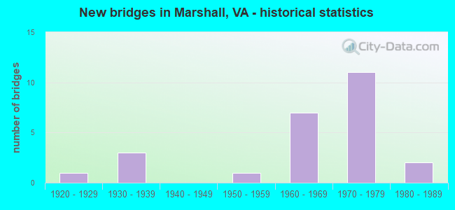
- New bridges - historical statistics
- 11920-1929
- 31930-1939
- 11950-1959
- 71960-1969
- 111970-1979
- 21980-1989

- Reconstructed bridges - Historical Statistics
- 11970-1979
- 11980-1989
- 21990-1999
- 12000-2009
- 12010-2019


- Bridge Condition - Deck
- 15.4%Very good
- 23.1%Good
- 38.5%Satisfactory
- 23.1%Fair

- Bridge Condition - Superstructure
- 7.7%Very good
- 23.1%Good
- 46.2%Satisfactory
- 23.1%Fair

- Bridge Condition - Substructure
- 30.8%Good
- 38.5%Satisfactory
- 30.8%Fair

- Bridge Condition - Channel
- 8.3%Good
- 58.3%Satisfactory
- 33.3%Fair

- Bridge Condition - Culverts
- 40.0%Good
- 40.0%Satisfactory
- 20.0%Fair
Find on map >> Show street view
Structure Number: 7104, Location: .40 Fr 723 & 1.08 To 713 (Lat: 38.885344, Lng: -77.905731), Route carried "on" structure: ServiceCounty highway F-185, Year Built: 1925, Status: Open, Structure Length: 0.73m (2.40ft), Average Daily Traffic: 2,129 (year 2015), Average Future Daily Traffic: 2,395 (year 2040), Design Load: HS 20, Features Intersected: Bolling Branch, Facility Carried by Structure: Grove Lane
Minimum Vertical Clearance: 30+ m (98+ ft), Kilometerpoint: 1.689, Lanes on structure: 2, Owner: State Highway Agency, Approaching Roadway Width: 6.1m (20.0ft), Skew: 4 degrees, Material/Design: Concrete, Design/Construction: Slab, Number Of Spans In Main Unit: 1, Length of Maximum Span: 6.1m (20.0ft), Curb-To-Curb Width: 5.9m (19.4ft), Out-to-Out Width: 6.9m (22.6ft)
Condition: Deck: Satisfactory, Superstructure: Satisfactory, Substructure: Satisfactory, Channel: Fair, Operating Rating: 43.5 metric tons, Method Used To Determine Operating Rating: Allowable Stress (AS), Inventory Rating: 22.7 metric tons, Method Used To Determine Inventory Rating: Allowable Stress (AS), Structural Evaluation: Equal to present minimum criteria, Deck Geometry: High priority of replacement, Waterway Adequacy: Equal to present minimum criteria, Approach Roadway Alignment: Equal to present desirable criteria, Length Of Structure Improvement: 0.73m (2.40ft), Designated Inspection Frequency: Every 24 months, Underwater Inspection Frequency: Every 60 months, Inspection Date: May 2021, Underwater Inspection Date: September 2017, Bridge Improvement Cost: $35,000, Roadway Improvement Cost: $5,000, Total Project Cost: $50,000 ( Estimate for 2015), Deck Structure Type: Concrete Cast-file-Place, Wearing Surface/Protective System: Wearing Surface: Bituminous
Find on map >> Show street view
Structure Number: 7141, Location: .14 Fr 698 & .87 To 699N (Lat: 38.806956, Lng: -77.812936), Route carried "on" structure: US 17, Year Built: 1938, Year Reconstructed: 1979, Status: Open, Structure Length: 0.69m (2.26ft), Average Daily Traffic: 8,456 (year 2020), Truck Traffic: 13%, Average Future Daily Traffic: 11,838 (year 2040), Design Load: HS 20, Features Intersected: Broad Run, Facility Carried by Structure: James Madison Hwy
Minimum Vertical Clearance: 30+ m (98+ ft), Kilometerpoint: 359.026, Lanes on structure: 2, Base Highway Network: Yes, Owner: State Highway Agency, Approaching Roadway Width: 8.5m (27.9ft), Material/Design: Concrete, Design/Construction: Slab, Number Of Spans In Main Unit: 1, Length of Maximum Span: 6.1m (20.0ft), Curb-To-Curb Width: 12.2m (40.0ft), Out-to-Out Width: 13.4m (44.0ft)
Condition: Deck: Fair, Superstructure: Fair, Substructure: Good, Channel: Good, Operating Rating: 49.9 metric tons, Method Used To Determine Operating Rating: Load Factor (LF), Inventory Rating: 29.9 metric tons, Method Used To Determine Inventory Rating: Load Factor (LF), Structural Evaluation: Somewhat better than minimum adequacy, Deck Geometry: Better than present minimum criteria, Waterway Adequacy: Equal to present desirable criteria, Approach Roadway Alignment: Equal to present desirable criteria, Designated Inspection Frequency: Every 24 months, Inspection Date: July 2021, Deck Structure Type: Concrete Cast-file-Place, Wearing Surface/Protective System: Wearing Surface: Bituminous
Find on map >> Show street view
Structure Number: 7151, Location: 1.3 FR 55 & 2.32 TO 245 (Lat: 38.857903, Lng: -77.843200), Route carried "on" structure: US 17, Year Built: 1978, Status: Open, Structure Length: 13.32m (43.70ft), Average Daily Traffic: 19,331 (year 2018), Truck Traffic: 13%, Average Future Daily Traffic: 17,500 (year 2031), Design Load: HS 20+Mod, Features Intersected: RTE 66, Facility Carried by Structure: WINCHESTER RD.
Minimum Vertical Clearance: 5.11m (16.77ft), Kilometerpoint: 365.513, Lanes on structure: 4, Lanes under structure: 4, Base Highway Network: Yes, Owner: State Highway Agency, Approaching Roadway Width: 18.9m (62.0ft), Skew: 24 degrees, Material/Design: Steel, Design/Construction: Stringer/Multi-beam, Number Of Spans In Main Unit: 5, Length of Maximum Span: 37.5m (123.0ft), Curb or Sidewalk Widths: Left: 0.3m (1.0ft), Right: 0.3m (1.0ft), Curb-To-Curb Width: 20.7m (67.9ft), Out-to-Out Width: 26.8m (87.9ft)
Condition: Deck: Satisfactory, Superstructure: Satisfactory, Substructure: Fair, Operating Rating: 71.7 metric tons, Method Used To Determine Operating Rating: Load and Resistance Factor (LRFR), Inventory Rating: 55.3 metric tons, Method Used To Determine Inventory Rating: Load and Resistance Factor (LRFR), Structural Evaluation: Somewhat better than minimum adequacy, Deck Geometry: Superior to present desirable criteria, Underclear: Equal to present minimum criteria, Approach Roadway Alignment: Equal to present desirable criteria, Designated Inspection Frequency: Every 24 months, Inspection Date: March 2020, Deck Structure Type: Concrete Cast-file-Place, Wearing Surface/Protective System: Wearing Surface: Epoxy Overlay
Find on map >> Show street view
Structure Number: 7155, Location: .28 Fr 713 &.18 To 66_EBL (Lat: 38.895664, Lng: -77.912811), Route carried "on" structure: Ramp Interstate 17, Year Built: 1960, Status: Open, Structure Length: 5.85m (19.19ft), Average Daily Traffic: 4,316 (year 2020), Average Future Daily Traffic: 6,042 (year 2040), Design Load: HS 20, Features Intersected: I-66 WBL
Minimum Vertical Clearance: 30+ m (98+ ft), Kilometerpoint: 0.080, Lanes on structure: 1, Lanes under structure: 2, Base Highway Network: Yes, Owner: State Highway Agency, Approaching Roadway Width: 8.5m (27.9ft), Skew: 4 degrees, Material/Design: Steel, Design/Construction: Stringer/Multi-beam, Number Of Spans In Main Unit: 3, Length of Maximum Span: 20.7m (67.9ft), Curb or Sidewalk Widths: Left: 0.5m (1.6ft), Right: 0.5m (1.6ft), Curb-To-Curb Width: 8.5m (27.9ft), Out-to-Out Width: 10.1m (33.1ft)
Condition: Deck: Fair, Superstructure: Fair, Substructure: Fair, Operating Rating: 59.0 metric tons, Method Used To Determine Operating Rating: Load and Resistance Factor (LRFR), Inventory Rating: 45.4 metric tons, Method Used To Determine Inventory Rating: Load and Resistance Factor (LRFR), Structural Evaluation: Somewhat better than minimum adequacy, Deck Geometry: Superior to present desirable criteria, Approach Roadway Alignment: Equal to present minimum criteria, Length Of Structure Improvement: 5.85m (19.19ft), Designated Inspection Frequency: Every 24 months, Inspection Date: September 2021, Bridge Improvement Cost: $40,000, Roadway Improvement Cost: $3,000, Total Project Cost: $50,000, Deck Structure Type: Concrete Cast-file-Place, Wearing Surface/Protective System: Wearing Surface: Latex Concrete
Find on map >> Show street view
Structure Number: 7165, Location: .14 Fr 698 & .87 To 699N (Lat: 38.807139, Lng: -77.812683), Route carried "on" structure: US 17, Year Built: 1987, Status: Open, Structure Length: 1.37m (4.49ft), Average Daily Traffic: 8,456 (year 2020), Truck Traffic: 13%, Average Future Daily Traffic: 11,838 (year 2040), Design Load: HS 20, Features Intersected: Broad Run, Facility Carried by Structure: James Madison Hwy
Minimum Vertical Clearance: 30+ m (98+ ft), Kilometerpoint: 359.019, Lanes on structure: 2, Base Highway Network: Yes, Owner: State Highway Agency, Approaching Roadway Width: 8.5m (27.9ft), Skew: 4 degrees, Material/Design: Concrete, Design/Construction: Culvert, Number Of Spans In Main Unit: 3, Length of Maximum Span: 4.3m (14.1ft)
Condition: Channel: Fair, Culverts: Good, Operating Rating: 69.9 metric tons, Method Used To Determine Operating Rating: Load Factor (LF), Inventory Rating: 41.7 metric tons, Method Used To Determine Inventory Rating: Load Factor (LF), Structural Evaluation: Better than present minimum criteria, Waterway Adequacy: Equal to present desirable criteria, Approach Roadway Alignment: Equal to present desirable criteria, Designated Inspection Frequency: Every 24 months, Inspection Date: July 2021
Find on map >> Show street view
Structure Number: 7195, Location: .82 Fr 17 & 1.62 To 723 (Lat: 38.884756, Lng: -77.906206), Route carried "on" structure: ServiceInterstate 66, Year Built: 1959, Status: Open, Structure Length: 0.85m (2.79ft), Average Daily Traffic: 43,794 (year 2020), Truck Traffic: 8%, Average Future Daily Traffic: 61,312 (year 2040), Design Load: HS 20, Features Intersected: Bolling Branch
Minimum Vertical Clearance: 30+ m (98+ ft), Kilometerpoint: 39.597, Lanes on structure: 6, Base Highway Network: Yes, Owner: State Highway Agency, Approaching Roadway Width: 22.9m (75.1ft), Skew: 4 degrees, Material/Design: Concrete, Design/Construction: Culvert, Number Of Spans In Main Unit: 3, Length of Maximum Span: 2.4m (7.9ft)
Condition: Channel: Satisfactory, Culverts: Satisfactory, Operating Rating: 89.8 metric tons, Method Used To Determine Operating Rating: Load Factor (LF), Inventory Rating: 89.8 metric tons, Method Used To Determine Inventory Rating: Load Factor (LF), Structural Evaluation: Equal to present minimum criteria, Waterway Adequacy: Equal to present desirable criteria, Approach Roadway Alignment: Equal to present desirable criteria, Designated Inspection Frequency: Every 24 months, Inspection Date: May 2021
Find on map >> Show street view
Structure Number: 7198, Location: 2.36 Fr 17N & 2.67 To 17S (Lat: 38.869111, Lng: -77.889308), Route carried "on" structure: Interstate 66, Year Built: 1978, Status: Open, Structure Length: 4.21m (13.81ft), Average Daily Traffic: 21,799 (year 2020), Truck Traffic: 8%, Average Future Daily Traffic: 30,519 (year 2040), Design Load: HS 20+Mod, Features Intersected: Route 732
Minimum Vertical Clearance: 30+ m (98+ ft), Kilometerpoint: 41.834, Lanes on structure: 2, Lanes under structure: 2, Base Highway Network: Yes, Owner: State Highway Agency, Approaching Roadway Width: 12.2m (40.0ft), Material/Design: Steel, Design/Construction: Stringer/Multi-beam, Number Of Spans In Main Unit: 3, Length of Maximum Span: 18.9m (62.0ft), Curb-To-Curb Width: 12.2m (40.0ft), Out-to-Out Width: 13.4m (44.0ft)
Condition: Deck: Satisfactory, Superstructure: Good, Substructure: Satisfactory, Operating Rating: 61.7 metric tons, Method Used To Determine Operating Rating: Load and Resistance Factor (LRFR), Inventory Rating: 48.1 metric tons, Method Used To Determine Inventory Rating: Load and Resistance Factor (LRFR), Structural Evaluation: Equal to present minimum criteria, Deck Geometry: Better than present minimum criteria, Underclear: Superior to present desirable criteria, Approach Roadway Alignment: Equal to present desirable criteria, Length Of Structure Improvement: 4.21m (13.81ft), Designated Inspection Frequency: Every 24 months, Inspection Date: Febuary 2021, Bridge Improvement Cost: $40,000, Roadway Improvement Cost: $5,000, Total Project Cost: $50,000, Deck Structure Type: Concrete Cast-file-Place, Wearing Surface/Protective System: Wearing Surface: Epoxy Overlay, Deck Protection: Epoxy Coated Reinforcing
Find on map >> Show street view
Structure Number: 7243, Location: 1.94 Fr 17 & 1.09 To 245 (Lat: 38.856450, Lng: -77.807917), Route carried "on" structure: Interstate 66, Year Built: 1979, Status: Open, Structure Length: 0.64m (2.10ft), Average Daily Traffic: 36,302 (year 2020), Truck Traffic: 8%, Average Future Daily Traffic: 50,823 (year 2040), Design Load: HS 20, Features Intersected: Stream
Minimum Vertical Clearance: 30+ m (98+ ft), Kilometerpoint: 49.573, Lanes on structure: 4, Base Highway Network: Yes, Owner: State Highway Agency, Approaching Roadway Width: 23.2m (76.1ft), Skew: 4 degrees, Material/Design: Concrete, Design/Construction: Culvert, Number Of Spans In Main Unit: 2, Length of Maximum Span: 2.4m (7.9ft)
Condition: Channel: Satisfactory, Culverts: Satisfactory, Operating Rating: 44.5 metric tons, Method Used To Determine Operating Rating: Field evaluation and documented engineering judgment, Inventory Rating: 32.7 metric tons, Method Used To Determine Inventory Rating: Field evaluation and documented engineering judgment, Structural Evaluation: Equal to present minimum criteria, Waterway Adequacy: Superior to present desirable criteria, Approach Roadway Alignment: Equal to present desirable criteria, Designated Inspection Frequency: Every 24 months, Inspection Date: March 2020
Find on map >> Show street view
Structure Number: 7292, Location: .10 Fr 713 & 1.50 To End (Lat: 38.915725, Lng: -77.867908), Route carried "on" structure: County highway 624, Year Built: 1986, Status: Open, Structure Length: 0.91m (2.99ft), Average Daily Traffic: 116 (year 2015), Average Future Daily Traffic: 164 (year 2040), Design Load: HS 20, Features Intersected: Branch Goose Creek, Facility Carried by Structure: Lost Corner Road
Minimum Vertical Clearance: 30+ m (98+ ft), Kilometerpoint: 2.405, Lanes on structure: 2, Owner: State Highway Agency, Approaching Roadway Width: 5.5m (18.0ft), Skew: 3 degrees, Material/Design: Concrete, Design/Construction: Slab, Number Of Spans In Main Unit: 1, Length of Maximum Span: 8.5m (27.9ft), Curb-To-Curb Width: 6.4m (21.0ft), Out-to-Out Width: 7.3m (24.0ft)
Condition: Deck: Satisfactory, Superstructure: Satisfactory, Substructure: Good, Channel: Satisfactory, Operating Rating: 64.4 metric tons, Method Used To Determine Operating Rating: Allowable Stress (AS), Inventory Rating: 36.3 metric tons, Method Used To Determine Inventory Rating: Allowable Stress (AS), Structural Evaluation: Equal to present minimum criteria, Deck Geometry: Meets minimum limits, Waterway Adequacy: Equal to present minimum criteria, Approach Roadway Alignment: Equal to present minimum criteria, Designated Inspection Frequency: Every 24 months, Inspection Date: November 2020, Deck Structure Type: Concrete Precast Panels
Find on map >> Show street view
Structure Number: 7384, Location: 4.60 Fr 630 & 1.60 To 719 (Lat: 38.814794, Lng: -77.862314), Route carried "on" structure: County highway 691, Year Built: 1968, Year Reconstructed: 1998, Status: Open, Structure Length: 1.07m (3.51ft), Average Daily Traffic: 390 (year 2015), Average Future Daily Traffic: 553 (year 2040), Design Load: HS 20, Features Intersected: Carters Run, Facility Carried by Structure: Carters Run Road
Minimum Vertical Clearance: 30+ m (98+ ft), Kilometerpoint: 15.446, Lanes on structure: 2, Owner: State Highway Agency, Approaching Roadway Width: 6.1m (20.0ft), Skew: 4 degrees, Material/Design: Steel, Design/Construction: Culvert, Number Of Spans In Main Unit: 2, Length of Maximum Span: 4.3m (14.1ft)
Condition: Channel: Fair, Culverts: Fair, Operating Rating: 44.5 metric tons, Method Used To Determine Operating Rating: Field evaluation and documented engineering judgment, Inventory Rating: 32.7 metric tons, Method Used To Determine Inventory Rating: Field evaluation and documented engineering judgment, Structural Evaluation: Somewhat better than minimum adequacy, Waterway Adequacy: Equal to present minimum criteria, Approach Roadway Alignment: Better than present minimum criteria, Designated Inspection Frequency: Every 24 months, Inspection Date: November 2021
Find on map >> Show street view
Structure Number: 7391, Location: 1.00 Fr 709 & .20 To 715 (Lat: 38.915883, Lng: -77.801811), Route carried "on" structure: County highway 708, Year Built: 1960, Year Reconstructed: 1993, Status: Open, Structure Length: 0.76m (2.49ft), Average Daily Traffic: 101 (year 2015), Average Future Daily Traffic: 152 (year 2040), Design Load: HS 20, Features Intersected: Branch Cromwells Creek, Facility Carried by Structure: Young Road
Minimum Vertical Clearance: 30+ m (98+ ft), Kilometerpoint: 1.442, Lanes on structure: 2, Owner: State Highway Agency, Approaching Roadway Width: 4.6m (15.1ft), Material/Design: Wood or Timber, Design/Construction: Slab, Number Of Spans In Main Unit: 1, Length of Maximum Span: 6.7m (22.0ft), Curb-To-Curb Width: 5.5m (18.0ft), Out-to-Out Width: 6.1m (20.0ft)
Condition: Deck: Good, Superstructure: Good, Substructure: Fair, Channel: Fair, Operating Rating: 89.8 metric tons, Method Used To Determine Operating Rating: Load and Resistance Factor (LRFR), Inventory Rating: 89.8 metric tons, Method Used To Determine Inventory Rating: Load and Resistance Factor (LRFR), Structural Evaluation: Somewhat better than minimum adequacy, Deck Geometry: High priority of corrective action, Waterway Adequacy: Better than present minimum criteria, Approach Roadway Alignment: Better than present minimum criteria, Length Of Structure Improvement: 0.76m (2.49ft), Designated Inspection Frequency: Every 24 months, Inspection Date: November 2021, Bridge Improvement Cost: $2,000, Roadway Improvement Cost: $1,000, Total Project Cost: $4,000 ( Estimate for 2015), Deck Structure Type: Wood or Timber, Wearing Surface/Protective System: Wearing Surface: Bituminous
Find on map >> Show street view
Structure Number: 7392, Location: .63 Fr 55 & .47 To 750 (Lat: 38.857372, Lng: -77.820506), Route carried "on" structure: County highway 709, Year Built: 1979, Status: Open, Structure Length: 8.20m (26.90ft), Average Daily Traffic: 2,320 (year 2020), Truck Traffic: 4%, Average Future Daily Traffic: 3,108 (year 2040), Design Load: HS 20+Mod, Features Intersected: I-66, Facility Carried by Structure: Belvoir Road
Minimum Vertical Clearance: 30+ m (98+ ft), Kilometerpoint: 1.609, Lanes on structure: 2, Lanes under structure: 4, Owner: State Highway Agency, Approaching Roadway Width: 6.4m (21.0ft), Material/Design: Steel continuous, Design/Construction: Stringer/Multi-beam, Number Of Spans In Main Unit: 2, Length of Maximum Span: 41.1m (134.8ft), Curb-To-Curb Width: 8.7m (28.5ft), Out-to-Out Width: 10.0m (32.8ft)
Condition: Deck: Good, Superstructure: Satisfactory, Substructure: Satisfactory, Operating Rating: 51.7 metric tons, Method Used To Determine Operating Rating: Load and Resistance Factor (LRFR), Inventory Rating: 39.9 metric tons, Method Used To Determine Inventory Rating: Load and Resistance Factor (LRFR), Structural Evaluation: Equal to present minimum criteria, Deck Geometry: Meets minimum limits, Underclear: Somewhat better than minimum adequacy, Approach Roadway Alignment: Equal to present desirable criteria, Designated Inspection Frequency: Every 24 months, Inspection Date: August 2021, Deck Structure Type: Concrete Cast-file-Place, Wearing Surface/Protective System: Wearing Surface: Epoxy Overlay
Find on map >> Show street view
Structure Number: 7404, Location: 1.40 Fr 624 & 1.50 To 17 (Lat: 38.913553, Lng: -77.890881), Route carried "on" structure: County highway 713, Year Built: 1938, Status: Open, Structure Length: 1.34m (4.40ft), Average Daily Traffic: 475 (year 2020), Truck Traffic: 2%, Average Future Daily Traffic: 665 (year 2040), Design Load: HS 20, Features Intersected: Bolling Branch, Facility Carried by Structure: Maidstone Road
Minimum Vertical Clearance: 30+ m (98+ ft), Kilometerpoint: 2.690, Lanes on structure: 2, Owner: State Highway Agency, Approaching Roadway Width: 5.2m (17.1ft), Material/Design: Concrete, Design/Construction: Slab, Number Of Spans In Main Unit: 2, Length of Maximum Span: 6.7m (22.0ft), Curb or Sidewalk Widths: Left: 0.2m (0.7ft), Right: 0.2m (0.7ft), Curb-To-Curb Width: 7.0m (23.0ft), Out-to-Out Width: 7.6m (24.9ft)
Condition: Deck: Fair, Superstructure: Fair, Substructure: Satisfactory, Channel: Satisfactory, Operating Rating: 47.2 metric tons, Method Used To Determine Operating Rating: Allowable Stress (AS), Inventory Rating: 27.2 metric tons, Method Used To Determine Inventory Rating: Allowable Stress (AS), Structural Evaluation: Somewhat better than minimum adequacy, Deck Geometry: Meets minimum limits, Waterway Adequacy: Better than present minimum criteria, Approach Roadway Alignment: Equal to present desirable criteria, Designated Inspection Frequency: Every 24 months, Inspection Date: June 2021, Deck Structure Type: Concrete Cast-file-Place, Wearing Surface/Protective System: Wearing Surface: Bituminous
Find on map >> Show street view
Structure Number: 7407, Location: 1.40 Fr 708 & 1.0 To 713 (Lat: 38.930931, Lng: -77.809794), Route carried "on" structure: County highway 715, Year Built: 1974, Year Reconstructed: 2018, Status: Open, Structure Length: 0.88m (2.89ft), Average Daily Traffic: 40 (year 2015), Average Future Daily Traffic: 45 (year 2040), Design Load: HL 93, Features Intersected: Cromwells Run, Facility Carried by Structure: Old CartersMill Rd
Minimum Vertical Clearance: 30+ m (98+ ft), Kilometerpoint: 3.532, Lanes on structure: 2, Owner: State Highway Agency, Approaching Roadway Width: 6.0m (19.7ft), Material/Design: Concrete, Design/Construction: Slab, Number Of Spans In Main Unit: 1, Length of Maximum Span: 7.8m (25.6ft), Curb-To-Curb Width: 6.0m (19.7ft), Out-to-Out Width: 6.1m (20.0ft)
Condition: Deck: Very good, Superstructure: Very good, Substructure: Good, Channel: Satisfactory, Operating Rating: 65.3 metric tons, Method Used To Determine Operating Rating: Load and Resistance Factor (LRFR), Inventory Rating: 49.9 metric tons, Method Used To Determine Inventory Rating: Load and Resistance Factor (LRFR), Structural Evaluation: Better than present minimum criteria, Deck Geometry: Meets minimum limits, Waterway Adequacy: Equal to present minimum criteria, Approach Roadway Alignment: Equal to present desirable criteria, Length Of Structure Improvement: 0.94m (3.08ft), Designated Inspection Frequency: Every 24 months, Inspection Date: July 2020, Bridge Improvement Cost: $40,000, Roadway Improvement Cost: $2,000, Total Project Cost: $45,000 ( Estimate for 2015), Deck Structure Type: Concrete Precast Panels, Wearing Surface/Protective System: Wearing Surface: Bituminous
Find on map >> Show street view
Structure Number: 7408, Location: 0.20 Fr 55 & 0.12 To 647 (Lat: 38.858811, Lng: -77.867772), Route carried "on" structure: County highway 721, Year Built: 1978, Status: Open, Structure Length: 7.13m (23.39ft), Average Daily Traffic: 21,719 (year 2005), Truck Traffic: 4%, Average Future Daily Traffic: 36,922 (year 2040), Design Load: HS 20, Features Intersected: I-66 EBL & WBL, Facility Carried by Structure: Free State Road
Minimum Vertical Clearance: 30+ m (98+ ft), Kilometerpoint: 10.066, Lanes on structure: 4, Lanes under structure: 4, Owner: State Highway Agency, Approaching Roadway Width: 15.8m (51.8ft), Skew: 20 degrees, Material/Design: Steel continuous, Design/Construction: Stringer/Multi-beam, Number Of Spans In Main Unit: 2, Length of Maximum Span: 35.7m (117.1ft), Curb-To-Curb Width: 20.7m (67.9ft), Out-to-Out Width: 26.8m (87.9ft)
Condition: Deck: Satisfactory, Superstructure: Good, Substructure: Satisfactory, Operating Rating: 66.2 metric tons, Method Used To Determine Operating Rating: Load and Resistance Factor (LRFR), Inventory Rating: 50.8 metric tons, Method Used To Determine Inventory Rating: Load and Resistance Factor (LRFR), Structural Evaluation: Equal to present minimum criteria, Deck Geometry: Superior to present desirable criteria, Underclear: Somewhat better than minimum adequacy, Approach Roadway Alignment: Equal to present desirable criteria, Designated Inspection Frequency: Every 24 months, Inspection Date: November 2020, Deck Structure Type: Concrete Cast-file-Place, Wearing Surface/Protective System: Wearing Surface: Epoxy Overlay
Find on map >> Show street view
Structure Number: 741, Location: .39 Fr 720 & .66 To 719 (Lat: 38.850475, Lng: -77.874944), Route carried "on" structure: County highway 721, Year Built: 1967, Year Reconstructed: 1998, Status: Open, Structure Length: 0.70m (2.30ft), Average Daily Traffic: 798 (year 2015), Average Future Daily Traffic: 898 (year 2040), Design Load: HS 20, Features Intersected: Carter Run, Facility Carried by Structure: Free State Road
Minimum Vertical Clearance: 30+ m (98+ ft), Kilometerpoint: 9.165, Lanes on structure: 2, Owner: State Highway Agency, Approaching Roadway Width: 5.5m (18.0ft), Material/Design: Steel, Design/Construction: Culvert, Number Of Spans In Main Unit: 2, Length of Maximum Span: 3.0m (9.8ft)
Condition: Channel: Satisfactory, Culverts: Good, Operating Rating: 44.5 metric tons, Method Used To Determine Operating Rating: Field evaluation and documented engineering judgment, Inventory Rating: 32.7 metric tons, Method Used To Determine Inventory Rating: Field evaluation and documented engineering judgment, Structural Evaluation: Better than present minimum criteria, Waterway Adequacy: Equal to present desirable criteria, Approach Roadway Alignment: Better than present minimum criteria, Designated Inspection Frequency: Every 24 months, Inspection Date: March 2022
Find on map >> Show street view
Structure Number: 7411, Location: .22 Fr F-184 & .30 To 731 (Lat: 38.878281, Lng: -77.909483), Route carried "on" structure: County highway 723, Year Built: 1937, Year Reconstructed: 2014, Status: Posted for load, Structure Length: 0.94m (3.08ft), Average Daily Traffic: 573 (year 2015), Average Future Daily Traffic: 719 (year 2040), Design Load: HS 20, Features Intersected: Branch Goose Creek, Facility Carried by Structure: Ashville Road
Minimum Vertical Clearance: 30+ m (98+ ft), Kilometerpoint: 0.603, Lanes on structure: 1, Owner: State Highway Agency, Approaching Roadway Width: 5.5m (18.0ft), Skew: 3 degrees, Material/Design: Steel, Design/Construction: Stringer/Multi-beam, Number Of Spans In Main Unit: 1, Length of Maximum Span: 8.2m (26.9ft), Curb or Sidewalk Widths: Left: 0.2m (0.7ft), Right: 0.2m (0.7ft), Curb-To-Curb Width: 4.3m (14.1ft), Out-to-Out Width: 4.6m (15.1ft)
Condition: Deck: Very good, Superstructure: Satisfactory, Substructure: Good, Channel: Satisfactory, Operating Rating: 38.1 metric tons, Method Used To Determine Operating Rating: Load Factor (LF), Inventory Rating: 22.7 metric tons, Method Used To Determine Inventory Rating: Load Factor (LF), Structural Evaluation: Equal to present minimum criteria, Deck Geometry: High priority of replacement, Waterway Adequacy: Somewhat better than minimum adequacy, Approach Roadway Alignment: Equal to present minimum criteria, Length Of Structure Improvement: 0.94m (3.08ft), Designated Inspection Frequency: Every 24 months, Inspection Date: December 2020, Bridge Improvement Cost: $80,000, Roadway Improvement Cost: $10,000, Total Project Cost: $100,000, Deck Structure Type: Wood or Timber, Wearing Surface/Protective System: Wearing Surface: Bituminous, Membrane: Preformed Fabric
Find on map >> Show street view
Structure Number: 7412, Location: .02 Fr F185 & .02 To F184 (Lat: 38.879383, Lng: -77.905622), Route carried "on" structure: County highway 723, Year Built: 1960, Status: Open, Structure Length: 6.31m (20.70ft), Average Daily Traffic: 975 (year 2015), Average Future Daily Traffic: 1,097 (year 2040), Design Load: HS 20, Features Intersected: I-66 EBL & WBL, Facility Carried by Structure: Ashville Road
Minimum Vertical Clearance: 30+ m (98+ ft), Kilometerpoint: 10.066, Lanes on structure: 4, Lanes under structure: 4, Owner: State Highway Agency, Approaching Roadway Width: 7.3m (24.0ft), Material/Design: Steel, Design/Construction: Stringer/Multi-beam, Number Of Spans In Main Unit: 4, Length of Maximum Span: 18.3m (60.0ft), Curb or Sidewalk Widths: Left: 0.5m (1.6ft), Right: 0.5m (1.6ft), Curb-To-Curb Width: 7.3m (24.0ft), Out-to-Out Width: 8.9m (29.2ft)
Condition: Deck: Good, Superstructure: Satisfactory, Substructure: Fair, Operating Rating: 48.1 metric tons, Method Used To Determine Operating Rating: Load and Resistance Factor (LRFR), Inventory Rating: 37.2 metric tons, Method Used To Determine Inventory Rating: Load and Resistance Factor (LRFR), Structural Evaluation: Somewhat better than minimum adequacy, Deck Geometry: High priority of replacement, Underclear: High priority of corrective action, Approach Roadway Alignment: Equal to present desirable criteria, Length Of Structure Improvement: 6.31m (20.70ft), Designated Inspection Frequency: Every 24 months, Inspection Date: August 2020, Bridge Improvement Cost: $50,000, Roadway Improvement Cost: $10,000, Total Project Cost: $70,000 ( Estimate for 2014), Deck Structure Type: Concrete Cast-file-Place, Wearing Surface/Protective System: Wearing Surface: Latex Concrete
Find on map >> Show street view
Structure Number: 7151, Location: 1.3 FR 55 & 2.32 TO 245 (Lat: 38.857903, Lng: -77.843200), Route carried "under" structure: Interstate 66, Year Built: 1978, Structure Length: 0. m, Average Daily Traffic: 34,326 (year 2008), Truck Traffic: 4%, Features Intersected: RTE 66, Facility Carried by Structure: WINCHESTER RD.
Minimum Vertical Clearance: 5.11m (16.77ft), Kilometerpoint: 46.114, Lanes on structure: 4, Lanes under structure: 4, Material/Design: Steel, Design/Construction: Stringer/Multi-beam, Length of Maximum Span: 37.5m (123.0ft)
Find on map >> Show street view
Structure Number: 7155, Location: .28 Fr 713 &.18 To 66_EBL (Lat: 38.895664, Lng: -77.912811), Route carried "under" structure: Interstate 66, Year Built: 1960, Structure Length: 0. m, Average Daily Traffic: 16,000 (year 1994), Features Intersected: I-66 WBL, Facility Carried by Structure: 17 SBL
Minimum Vertical Clearance: 4.65m (15.26ft), Kilometerpoint: 0.000, Lanes on structure: 1, Lanes under structure: 2, Material/Design: Steel, Design/Construction: Stringer/Multi-beam, Length of Maximum Span: 20.7m (67.9ft)
Find on map >> Show street view
Structure Number: 7198, Location: 2.36 Fr 17N & 2.67 To 17S (Lat: 38.869111, Lng: -77.889308), Route carried "under" structure: Interstate 732, Year Built: 1978, Structure Length: 0. m, Average Daily Traffic: 714 (year 2001), Features Intersected: Route 732, Facility Carried by Structure: I-66 WBL
Minimum Vertical Clearance: 5.05m (16.57ft), Kilometerpoint: 17.184, Lanes on structure: 2, Lanes under structure: 2, Material/Design: Steel, Design/Construction: Stringer/Multi-beam, Length of Maximum Span: 18.9m (62.0ft)
Find on map >> Show street view
Structure Number: 72, Location: 2.36 Fr 17N & 2.67 To 17S (Lat: 38.868967, Lng: -77.889428), Route carried "under" structure: County highway 732, Year Built: 1978, Structure Length: 0. m, Average Daily Traffic: 714 (year 2001), Features Intersected: Route 732, Facility Carried by Structure: I-66 EBL
Minimum Vertical Clearance: 4.98m (16.34ft), Kilometerpoint: 17.184, Lanes on structure: 2, Lanes under structure: 2, Material/Design: Steel, Design/Construction: Stringer/Multi-beam, Length of Maximum Span: 15.8m (51.8ft)
Find on map >> Show street view
Structure Number: 7392, Location: .63 Fr 55 & .47 To 750 (Lat: 38.857372, Lng: -77.820506), Route carried "under" structure: Interstate 66, Year Built: 1979, Structure Length: 0. m, Average Daily Traffic: 12,000 (year 1997), Features Intersected: I-66, Facility Carried by Structure: Belvoir Road
Minimum Vertical Clearance: 5.05m (16.57ft), Kilometerpoint: 48.399, Lanes on structure: 2, Lanes under structure: 4, Material/Design: Steel continuous, Design/Construction: Stringer/Multi-beam, Length of Maximum Span: 41.1m (134.8ft)
Find on map >> Show street view
Structure Number: 7408, Location: 0.20 Fr 55 & 0.12 To 647 (Lat: 38.858811, Lng: -77.867772), Route carried "under" structure: County highway 66, Year Built: 1978, Structure Length: 0. m, Average Daily Traffic: 39,688 (year 2008), Truck Traffic: 4%, Features Intersected: I-66 EBL & WBL, Facility Carried by Structure: Free State Road
Minimum Vertical Clearance: 5.05m (16.57ft), Kilometerpoint: 44.006, Lanes on structure: 4, Lanes under structure: 4, Material/Design: Steel continuous, Design/Construction: Stringer/Multi-beam, Length of Maximum Span: 35.7m (117.1ft)
Find on map >> Show street view
Structure Number: 7412, Location: .02 Fr F185 & .02 To F184 (Lat: 38.879383, Lng: -77.905622), Route carried "under" structure: Interstate 66, Year Built: 1960, Structure Length: 0. m, Average Daily Traffic: 39,687 (year 2008), Truck Traffic: 4%, Features Intersected: I-66 EBL & WBL, Facility Carried by Structure: Ashville Road
Minimum Vertical Clearance: 4.77m (15.65ft), Kilometerpoint: 39.533, Lanes on structure: 4, Lanes under structure: 4, Material/Design: Steel, Design/Construction: Stringer/Multi-beam, Length of Maximum Span: 18.3m (60.0ft)