Bridge Statistics for Marshfield, Missouri (MO)
Condition, Traffic, Stress, Structural Evaluation, Project Costs
- National Bridge Inventory (NBI) Statistics
- 34Number of bridges
- 217ft / 66.0mTotal length
- $4,202,000Total costs
- 192,221Total average daily traffic
- 47,179Total average daily truck traffic
- National Bridge Inventory (NBI) Registered Bridges for Marshfield
- No street view available for this location
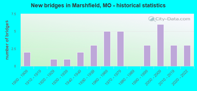
- New bridges - historical statistics
- 21900-1909
- 11920-1929
- 11930-1939
- 21940-1949
- 31950-1959
- 51960-1969
- 51970-1979
- 31990-1999
- 62000-2009
- 32010-2019
- 32020-2022
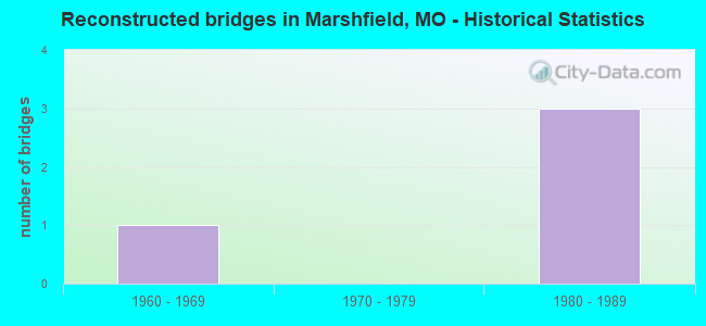
- Reconstructed bridges - Historical Statistics
- 11960-1969
- 01970-1979
- 31980-1989
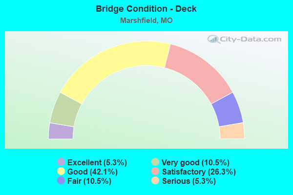
- Bridge Condition - Deck
- 5.3%Excellent
- 10.5%Very good
- 42.1%Good
- 26.3%Satisfactory
- 10.5%Fair
- 5.3%Serious
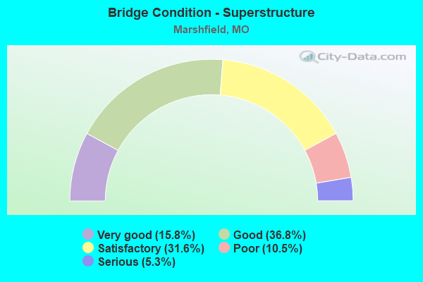
- Bridge Condition - Superstructure
- 15.8%Very good
- 36.8%Good
- 31.6%Satisfactory
- 10.5%Poor
- 5.3%Serious
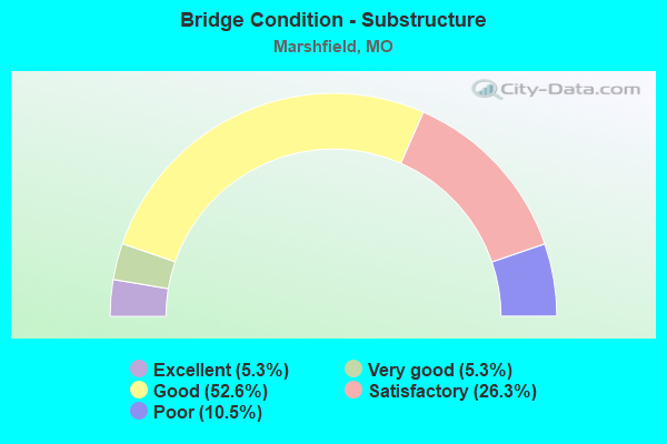
- Bridge Condition - Substructure
- 5.3%Excellent
- 5.3%Very good
- 52.6%Good
- 26.3%Satisfactory
- 10.5%Poor
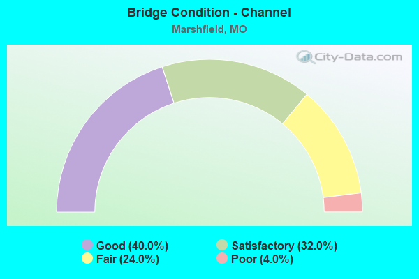
- Bridge Condition - Channel
- 40.0%Good
- 32.0%Satisfactory
- 24.0%Fair
- 4.0%Poor
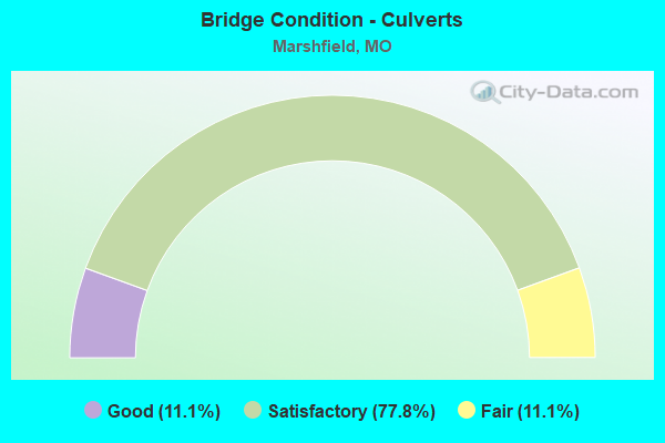
- Bridge Condition - Culverts
- 11.1%Good
- 77.8%Satisfactory
- 11.1%Fair
Find on map >> Show street view
Structure Number: 11943, Location: S 18 T 30 N R 17 W (Lat: 37.314803, Lng: -92.851458), Route carried "on" structure: State highway 38, Year Built: 2000, Status: Open, Structure Length: 4.39m (14.40ft), Average Daily Traffic: 3,662 (year 2021), Truck Traffic: 14%, Average Future Daily Traffic: 6,409 (year 2041), Design Load: HS 20, Features Intersected: HANNAH CR
Minimum Vertical Clearance: 30+ m (98+ ft), Kilometerpoint: 45.137, Lanes on structure: 2, Base Highway Network: Yes, Owner: State Highway Agency, Approaching Roadway Width: 11.9m (39.0ft), Skew: 2 degrees, Material/Design: Prestressed concrete continuous, Design/Construction: Stringer/Multi-beam, Number Of Spans In Main Unit: 3, Length of Maximum Span: 15.5m (50.9ft), Curb-To-Curb Width: 12.0m (39.4ft), Out-to-Out Width: 12.8m (42.0ft)
Condition: Deck: Good, Superstructure: Very good, Substructure: Very good, Channel: Good, Operating Rating: 72.9 metric tons, Method Used To Determine Operating Rating: Load Factor (LF), Inventory Rating: 44.1 metric tons, Method Used To Determine Inventory Rating: Load Factor (LF), Structural Evaluation: Equal to present desirable criteria, Deck Geometry: Somewhat better than minimum adequacy, Waterway Adequacy: Equal to present desirable criteria, Approach Roadway Alignment: Equal to present desirable criteria, Designated Inspection Frequency: Every 24 months, Inspection Date: November 2020, Deck Structure Type: Concrete Cast-file-Place, Wearing Surface/Protective System: Wearing Surface: Monolithic Concrete, Deck Protection: Epoxy Coated Reinforcing
Find on map >> Show street view
Structure Number: 13799, Location: S 19 T 31 N R 18 W (Lat: 37.394886, Lng: -92.958842), Route carried "on" structure: County highway 632, Year Built: 1996, Status: Open, Structure Length: 0.98m (3.22ft), Average Daily Traffic: 30 (year 2019), Truck Traffic: 10%, Average Future Daily Traffic: 50 (year 2039), Design Load: HS 20, Features Intersected: W FK OF NIANGUA RV, Facility Carried by Structure: GREER CREEK RD
Minimum Vertical Clearance: 30+ m (98+ ft), Kilometerpoint: 0.064, Lanes on structure: 2, Owner: County Highway Agency, Approaching Roadway Width: 6.7m (22.0ft), Skew: 2 degrees, Material/Design: Concrete continuous, Design/Construction: Slab, Number Of Spans In Main Unit: 3, Length of Maximum Span: 3.4m (11.2ft), Curb-To-Curb Width: 5.5m (18.0ft), Out-to-Out Width: 6.1m (20.0ft)
Condition: Deck: Satisfactory, Superstructure: Satisfactory, Substructure: Satisfactory, Channel: Satisfactory, Operating Rating: 45.0 metric tons, Method Used To Determine Operating Rating: Load Factor (LF), Inventory Rating: 32.4 metric tons, Method Used To Determine Inventory Rating: Load Factor (LF), Structural Evaluation: Equal to present minimum criteria, Deck Geometry: Meets minimum limits, Waterway Adequacy: Better than present minimum criteria, Approach Roadway Alignment: Equal to present minimum criteria, Designated Inspection Frequency: Every 24 months, Inspection Date: April 2021, Deck Structure Type: Concrete Cast-file-Place, Wearing Surface/Protective System: Wearing Surface: Monolithic Concrete
Find on map >> Show street view
Structure Number: 13803, Location: S 19 T 31 N R 18 W (Lat: 37.394794, Lng: -92.958378), Route carried "on" structure: County highway 632, Year Built: 1995, Status: Open, Structure Length: 0.61m (2.00ft), Average Daily Traffic: 30 (year 2019), Truck Traffic: 10%, Average Future Daily Traffic: 50 (year 2039), Design Load: HS 20, Features Intersected: W FK OF NIANGUA RV, Facility Carried by Structure: GREER CREEK RD
Minimum Vertical Clearance: 30+ m (98+ ft), Kilometerpoint: 0.080, Lanes on structure: 2, Owner: County Highway Agency, Approaching Roadway Width: 6.7m (22.0ft), Material/Design: Concrete continuous, Design/Construction: Slab, Number Of Spans In Main Unit: 2, Length of Maximum Span: 3.0m (9.8ft), Curb-To-Curb Width: 7.8m (25.6ft), Out-to-Out Width: 7.8m (25.6ft)
Condition: Deck: Good, Superstructure: Good, Substructure: Good, Channel: Satisfactory, Operating Rating: 45.0 metric tons, Method Used To Determine Operating Rating: Load Factor (LF), Inventory Rating: 32.4 metric tons, Method Used To Determine Inventory Rating: Load Factor (LF), Structural Evaluation: Better than present minimum criteria, Deck Geometry: Equal to present minimum criteria, Waterway Adequacy: Better than present minimum criteria, Approach Roadway Alignment: Equal to present desirable criteria, Designated Inspection Frequency: Every 24 months, Inspection Date: April 2021, Deck Structure Type: Concrete Cast-file-Place, Wearing Surface/Protective System: Wearing Surface: Bituminous
Find on map >> Show street view
Structure Number: 13946, Location: S 25 T 31 N R 19 W (Lat: 37.384339, Lng: -92.976958), Route carried "on" structure: County highway 52, Year Built: 1963, Status: Open, Structure Length: 0.73m (2.40ft), Average Daily Traffic: 60 (year 2019), Truck Traffic: 10%, Average Future Daily Traffic: 99 (year 2039), Features Intersected: BR OF W FK NIANGUA, Facility Carried by Structure: TIMBER RIDGE RD
Minimum Vertical Clearance: 30+ m (98+ ft), Kilometerpoint: 1.931, Lanes on structure: 2, Owner: County Highway Agency, Approaching Roadway Width: 7.3m (24.0ft), Material/Design: Concrete, Design/Construction: Culvert, Number Of Spans In Main Unit: 2, Length of Maximum Span: 3.7m (12.1ft), Curb-To-Curb Width: 7.1m (23.3ft), Out-to-Out Width: 7.7m (25.3ft)
Condition: Channel: Fair, Culverts: Satisfactory, Operating Rating: 49.5 metric tons, Method Used To Determine Operating Rating: Allowable Stress (AS), Inventory Rating: 16.2 metric tons, Method Used To Determine Inventory Rating: Allowable Stress (AS), Structural Evaluation: Somewhat better than minimum adequacy, Deck Geometry: Somewhat better than minimum adequacy, Waterway Adequacy: Better than present minimum criteria, Approach Roadway Alignment: Equal to present desirable criteria, Designated Inspection Frequency: Every 24 months, Inspection Date: April 2021
Find on map >> Show street view
Structure Number: 1461, Location: S 5 T 30 N R 18 W (Lat: 37.342828, Lng: -92.930681), Route carried "on" structure: State highway 38, Year Built: 1968, Year Reconstructed: 1989, Status: Open, Structure Length: 5.94m (19.49ft), Average Daily Traffic: 18,932 (year 2021), Truck Traffic: 6%, Average Future Daily Traffic: 33,131 (year 2041), Design Load: H 20, Features Intersected: IS 44
Minimum Vertical Clearance: 30+ m (98+ ft), Kilometerpoint: 36.881, Lanes on structure: 5, Lanes under structure: 4, Owner: State Highway Agency, Approaching Roadway Width: 21.3m (69.9ft), Material/Design: Steel continuous, Design/Construction: Stringer/Multi-beam, Number Of Spans In Main Unit: 4, Length of Maximum Span: 18.3m (60.0ft), Curb-To-Curb Width: 21.3m (69.9ft), Out-to-Out Width: 22.2m (72.8ft)
Condition: Deck: Satisfactory, Superstructure: Satisfactory, Substructure: Satisfactory, Operating Rating: 45.0 metric tons, Method Used To Determine Operating Rating: Allowable Stress (AS), Inventory Rating: 28.8 metric tons, Method Used To Determine Inventory Rating: Allowable Stress (AS), Structural Evaluation: Equal to present minimum criteria, Deck Geometry: Somewhat better than minimum adequacy, Underclear: Somewhat better than minimum adequacy, Approach Roadway Alignment: Equal to present desirable criteria, Designated Inspection Frequency: Every 24 months, Inspection Date: November 2020, Deck Structure Type: Concrete Cast-file-Place, Wearing Surface/Protective System: Wearing Surface: Low Slump Concrete
Find on map >> Show street view
Structure Number: 18835, Location: S 24 T 30 N R 18 W (Lat: 37.302719, Lng: -92.866306), Route carried "on" structure: County highway 201, Year Built: 1900, Status: Posted for load, Structure Length: 0.67m (2.20ft), Average Daily Traffic: 100 (year 2019), Truck Traffic: 10%, Average Future Daily Traffic: 165 (year 2039), Features Intersected: BR OF OSAGE FK, Facility Carried by Structure: WILD CHERRY LN
Minimum Vertical Clearance: 30+ m (98+ ft), Kilometerpoint: 1.287, Lanes on structure: 2, Owner: County Highway Agency, Approaching Roadway Width: 6.7m (22.0ft), Material/Design: Steel, Design/Construction: Stringer/Multi-beam, Number Of Spans In Main Unit: 1, Length of Maximum Span: 6.4m (21.0ft), Curb-To-Curb Width: 6.4m (21.0ft), Out-to-Out Width: 6.7m (22.0ft)
Condition: Deck: Good, Superstructure: Satisfactory, Substructure: Good, Channel: Good, Operating Rating: 18.0 metric tons, Method Used To Determine Operating Rating: Allowable Stress (AS), Inventory Rating: 9.0 metric tons, Method Used To Determine Inventory Rating: Allowable Stress (AS), Structural Evaluation: High priority of corrective action, Deck Geometry: Somewhat better than minimum adequacy, Waterway Adequacy: Better than present minimum criteria, Approach Roadway Alignment: Equal to present desirable criteria, Bridge Posting: Required (Relationship of Operating Rating to Maximum Legal Load: 20.0 - 29.9% below), Length Of Structure Improvement: 0.13m (0.43ft), Designated Inspection Frequency: Every 24 months, Inspection Date: April 2021, Bridge Improvement Cost: $65,000, Roadway Improvement Cost: $6,000, Total Project Cost: $97,000 ( Estimate for 2022), Deck Structure Type: Concrete Cast-file-Place, Wearing Surface/Protective System: Wearing Surface: Gravel
Find on map >> Show street view
Structure Number: 18839, Location: S 24 T 30 N R 18 W (Lat: 37.302631, Lng: -92.866392), Route carried "on" structure: County highway 201, Year Built: 1977, Status: Open, Structure Length: 0.76m (2.49ft), Average Daily Traffic: 100 (year 2019), Truck Traffic: 10%, Average Future Daily Traffic: 165 (year 2039), Features Intersected: BR OF OSAGE FK, Facility Carried by Structure: OLD SEYMOUR RD
Minimum Vertical Clearance: 30+ m (98+ ft), Kilometerpoint: 1.448, Lanes on structure: 2, Owner: County Highway Agency, Approaching Roadway Width: 7.3m (24.0ft), Material/Design: Concrete, Design/Construction: Culvert, Number Of Spans In Main Unit: 2, Length of Maximum Span: 3.7m (12.1ft), Curb-To-Curb Width: 7.6m (24.9ft), Out-to-Out Width: 8.2m (26.9ft)
Condition: Channel: Good, Culverts: Satisfactory, Operating Rating: 49.5 metric tons, Method Used To Determine Operating Rating: Allowable Stress (AS), Inventory Rating: 16.2 metric tons, Method Used To Determine Inventory Rating: Allowable Stress (AS), Structural Evaluation: Somewhat better than minimum adequacy, Deck Geometry: Equal to present minimum criteria, Waterway Adequacy: Better than present minimum criteria, Approach Roadway Alignment: Equal to present desirable criteria, Designated Inspection Frequency: Every 24 months, Inspection Date: April 2021
Find on map >> Show street view
Structure Number: 19521, Location: S 2 T 30 N R 18 W (Lat: 37.349919, Lng: -92.875353), Route carried "on" structure: County highway 223, Year Built: 1900, Status: Open, Structure Length: 1.31m (4.30ft), Average Daily Traffic: 200 (year 2019), Truck Traffic: 10%, Average Future Daily Traffic: 320 (year 2039), Features Intersected: E FK NIANGUA RVR, Facility Carried by Structure: GOLF COURSE RD
Minimum Vertical Clearance: 30+ m (98+ ft), Kilometerpoint: 1.609, Lanes on structure: 2, Owner: County Highway Agency, Approaching Roadway Width: 7.3m (24.0ft), Material/Design: Concrete, Design/Construction: Culvert, Number Of Spans In Main Unit: 3, Length of Maximum Span: 4.3m (14.1ft), Curb-To-Curb Width: 6.9m (22.6ft), Out-to-Out Width: 7.3m (24.0ft)
Condition: Channel: Fair, Culverts: Satisfactory, Operating Rating: 49.5 metric tons, Method Used To Determine Operating Rating: Allowable Stress (AS), Inventory Rating: 16.2 metric tons, Method Used To Determine Inventory Rating: Allowable Stress (AS), Structural Evaluation: Somewhat better than minimum adequacy, Deck Geometry: Meets minimum limits, Waterway Adequacy: Better than present minimum criteria, Approach Roadway Alignment: Equal to present desirable criteria, Designated Inspection Frequency: Every 24 months, Inspection Date: April 2021, Deck Structure Type: Concrete Cast-file-Place, Wearing Surface/Protective System: Wearing Surface: Bituminous
Find on map >> Show street view
Structure Number: 2379, Location: S 22 T 31 N R 18 W (Lat: 37.383197, Lng: -92.902444), Route carried "on" structure: County highway , Year Built: 1972, Status: Open, Structure Length: 7.01m (23.00ft), Average Daily Traffic: 736 (year 2021), Truck Traffic: 11%, Average Future Daily Traffic: 1,178 (year 2041), Design Load: H 15, Features Intersected: IS 44, Facility Carried by Structure: PLANK SCHOOL RD E
Minimum Vertical Clearance: 30+ m (98+ ft), Kilometerpoint: 0.040, Lanes on structure: 2, Lanes under structure: 4, Owner: State Highway Agency, Approaching Roadway Width: 6.7m (22.0ft), Material/Design: Steel continuous, Design/Construction: Stringer/Multi-beam, Number Of Spans In Main Unit: 4, Length of Maximum Span: 23.2m (76.1ft), Curb-To-Curb Width: 8.5m (27.9ft), Out-to-Out Width: 9.4m (30.8ft)
Condition: Deck: Satisfactory, Superstructure: Satisfactory, Substructure: Good, Operating Rating: 30.6 metric tons, Method Used To Determine Operating Rating: Load Factor (LF), Inventory Rating: 18.0 metric tons, Method Used To Determine Inventory Rating: Load Factor (LF), Structural Evaluation: Somewhat better than minimum adequacy, Deck Geometry: Somewhat better than minimum adequacy, Underclear: Better than present minimum criteria, Approach Roadway Alignment: Equal to present desirable criteria, Designated Inspection Frequency: Every 24 months, Inspection Date: November 2020, Deck Structure Type: Concrete Cast-file-Place, Wearing Surface/Protective System: Wearing Surface: Bituminous
Find on map >> Show street view
Structure Number: 23936, Location: S 29 T 31 N R 18 W (Lat: 37.369033, Lng: -92.934994), Route carried "on" structure: County highway 445, Year Built: 1974, Status: Open, Structure Length: 0.70m (2.30ft), Average Daily Traffic: 30 (year 2019), Truck Traffic: 10%, Average Future Daily Traffic: 50 (year 2039), Features Intersected: BR OF W FK NIANGUA, Facility Carried by Structure: WILDFLOWER RD
Minimum Vertical Clearance: 30+ m (98+ ft), Kilometerpoint: 0.966, Lanes on structure: 2, Owner: County Highway Agency, Approaching Roadway Width: 6.7m (22.0ft), Material/Design: Concrete, Design/Construction: Culvert, Number Of Spans In Main Unit: 2, Length of Maximum Span: 3.7m (12.1ft), Curb-To-Curb Width: 6.9m (22.6ft), Out-to-Out Width: 7.4m (24.3ft)
Condition: Channel: Poor, Culverts: Fair, Operating Rating: 49.5 metric tons, Method Used To Determine Operating Rating: Allowable Stress (AS), Inventory Rating: 16.2 metric tons, Method Used To Determine Inventory Rating: Allowable Stress (AS), Structural Evaluation: Somewhat better than minimum adequacy, Deck Geometry: Somewhat better than minimum adequacy, Waterway Adequacy: Better than present minimum criteria, Approach Roadway Alignment: Equal to present desirable criteria, Designated Inspection Frequency: Every 24 months, Inspection Date: April 2021
Find on map >> Show street view
Structure Number: 28347, Location: S 10 T 30 N R 18 W (Lat: 37.327458, Lng: -92.911567), Route carried "on" structure: County highway , Year Built: 1998, Status: Open, Structure Length: 0.79m (2.59ft), Average Daily Traffic: 350 (year 2019), Truck Traffic: 10%, Average Future Daily Traffic: 560 (year 2039), Features Intersected: BR OF TURNBO CR, Facility Carried by Structure: S WHITE OAK RD
Minimum Vertical Clearance: 30+ m (98+ ft), Kilometerpoint: 0.322, Lanes on structure: 2, Owner: City or Municipal Highway Agency, Maintenance Responsibility: County Highway Agency, Approaching Roadway Width: 6.7m (22.0ft), Skew: 3 degrees, Material/Design: Concrete continuous, Design/Construction: Slab, Number Of Spans In Main Unit: 2, Length of Maximum Span: 3.7m (12.1ft), Curb-To-Curb Width: 7.4m (24.3ft), Out-to-Out Width: 7.4m (24.3ft)
Condition: Deck: Good, Superstructure: Good, Substructure: Good, Channel: Good, Operating Rating: 54.0 metric tons, Method Used To Determine Operating Rating: Load Factor (LF), Inventory Rating: 32.4 metric tons, Method Used To Determine Inventory Rating: Load Factor (LF), Structural Evaluation: Better than present minimum criteria, Deck Geometry: Somewhat better than minimum adequacy, Waterway Adequacy: Better than present minimum criteria, Approach Roadway Alignment: Equal to present desirable criteria, Designated Inspection Frequency: Every 24 months, Inspection Date: April 2021, Deck Structure Type: Concrete Cast-file-Place
Find on map >> Show street view
Structure Number: 28697, Location: S 23 T 30 N R 19 W (Lat: 37.303936, Lng: -92.984828), Route carried "on" structure: County highway 262, Year Built: 2001, Status: Open, Structure Length: 1.77m (5.81ft), Average Daily Traffic: 428 (year 2019), Truck Traffic: 10%, Average Future Daily Traffic: 706 (year 2039), Features Intersected: POMME DE TERRE RVR, Facility Carried by Structure: COLOGNA RD
Minimum Vertical Clearance: 30+ m (98+ ft), Kilometerpoint: 4.023, Lanes on structure: 2, Owner: County Highway Agency, Approaching Roadway Width: 6.1m (20.0ft), Skew: 3 degrees, Material/Design: Concrete continuous, Design/Construction: Culvert, Number Of Spans In Main Unit: 3, Length of Maximum Span: 5.8m (19.0ft), Curb-To-Curb Width: 18.9m (62.0ft), Out-to-Out Width: 19.8m (65.0ft)
Condition: Channel: Satisfactory, Culverts: Satisfactory, Operating Rating: 66.6 metric tons, Method Used To Determine Operating Rating: Load Factor (LF), Inventory Rating: 39.6 metric tons, Method Used To Determine Inventory Rating: Load Factor (LF), Structural Evaluation: Equal to present minimum criteria, Deck Geometry: Superior to present desirable criteria, Waterway Adequacy: Equal to present minimum criteria, Approach Roadway Alignment: Equal to present minimum criteria, Designated Inspection Frequency: Every 24 months, Inspection Date: April 2021, Deck Structure Type: Concrete Cast-file-Place, Wearing Surface/Protective System: Wearing Surface: Monolithic Concrete, Deck Protection: Epoxy Coated Reinforcing
Find on map >> Show street view
Structure Number: 30944, Location: S 20 T 30 N R 18 W (Lat: 37.308500, Lng: -92.935808), Route carried "on" structure: County highway 229, Year Built: 2001, Status: Open, Structure Length: 1.68m (5.51ft), Average Daily Traffic: 350 (year 2019), Truck Traffic: 10%, Average Future Daily Traffic: 578 (year 2039), Design Load: HS 20, Features Intersected: TURNBO CR, Facility Carried by Structure: TURNBO RD
Minimum Vertical Clearance: 30+ m (98+ ft), Kilometerpoint: 0.000, Lanes on structure: 2, Owner: County Highway Agency, Approaching Roadway Width: 6.7m (22.0ft), Skew: 4 degrees, Material/Design: Concrete continuous, Design/Construction: Slab, Number Of Spans In Main Unit: 3, Length of Maximum Span: 4.9m (16.1ft), Curb-To-Curb Width: 7.3m (24.0ft), Out-to-Out Width: 7.9m (25.9ft)
Condition: Deck: Good, Superstructure: Good, Substructure: Good, Channel: Satisfactory, Operating Rating: 44.1 metric tons, Method Used To Determine Operating Rating: Load Factor (LF), Inventory Rating: 27.0 metric tons, Method Used To Determine Inventory Rating: Load Factor (LF), Structural Evaluation: Equal to present minimum criteria, Deck Geometry: Somewhat better than minimum adequacy, Waterway Adequacy: Better than present minimum criteria, Approach Roadway Alignment: Equal to present minimum criteria, Designated Inspection Frequency: Every 24 months, Inspection Date: April 2021, Deck Structure Type: Concrete Cast-file-Place
Find on map >> Show street view
Structure Number: 32845, Location: S 28 T 31 N R 18 W (Lat: 37.376736, Lng: -92.919522), Route carried "on" structure: County highway , Year Built: 2009, Status: Open, Structure Length: 2.29m (7.51ft), Average Daily Traffic: 60 (year 2019), Truck Traffic: 10%, Average Future Daily Traffic: 99 (year 2039), Design Load: HS 20+Mod, Features Intersected: W FK OF NIANGUA RV, Facility Carried by Structure: VINYARD RD
Minimum Vertical Clearance: 30+ m (98+ ft), Kilometerpoint: 0.000, Lanes on structure: 2, Owner: County Highway Agency, Approaching Roadway Width: 7.3m (24.0ft), Skew: 2 degrees, Material/Design: Steel, Design/Construction: Stringer/Multi-beam, Number Of Spans In Main Unit: 1, Length of Maximum Span: 22.9m (75.1ft), Curb-To-Curb Width: 7.3m (24.0ft), Out-to-Out Width: 7.5m (24.6ft)
Condition: Deck: Good, Superstructure: Good, Substructure: Good, Channel: Good, Operating Rating: 42.3 metric tons, Method Used To Determine Operating Rating: Load Factor (LF), Inventory Rating: 25.2 metric tons, Method Used To Determine Inventory Rating: Load Factor (LF), Structural Evaluation: Equal to present minimum criteria, Deck Geometry: Equal to present minimum criteria, Waterway Adequacy: Equal to present desirable criteria, Approach Roadway Alignment: Equal to present desirable criteria, Designated Inspection Frequency: Every 24 months, Inspection Date: April 2021, Deck Structure Type: Concrete Cast-file-Place, Wearing Surface/Protective System: Wearing Surface: Monolithic Concrete
Find on map >> Show street view
Structure Number: 32847, Location: S 25 T 31 N R 18 W (Lat: 37.382717, Lng: -92.881114), Route carried "on" structure: County highway , Year Built: 2009, Status: Open, Structure Length: 2.39m (7.84ft), Average Daily Traffic: 40 (year 2019), Truck Traffic: 10%, Average Future Daily Traffic: 66 (year 2039), Design Load: HS 20+Mod, Features Intersected: E FK OF NIANGUA RV, Facility Carried by Structure: PLANK SCHOOL RD
Minimum Vertical Clearance: 30+ m (98+ ft), Kilometerpoint: 0.000, Lanes on structure: 2, Owner: County Highway Agency, Approaching Roadway Width: 7.3m (24.0ft), Material/Design: Steel, Design/Construction: Stringer/Multi-beam, Number Of Spans In Main Unit: 1, Length of Maximum Span: 23.9m (78.4ft), Curb-To-Curb Width: 7.3m (24.0ft), Out-to-Out Width: 7.5m (24.6ft)
Condition: Deck: Very good, Superstructure: Good, Substructure: Good, Channel: Good, Operating Rating: 54.0 metric tons, Method Used To Determine Operating Rating: Load Factor (LF), Inventory Rating: 32.4 metric tons, Method Used To Determine Inventory Rating: Load Factor (LF), Structural Evaluation: Better than present minimum criteria, Deck Geometry: Equal to present minimum criteria, Waterway Adequacy: Better than present minimum criteria, Approach Roadway Alignment: Equal to present minimum criteria, Designated Inspection Frequency: Every 24 months, Inspection Date: April 2021, Deck Structure Type: Concrete Cast-file-Place, Wearing Surface/Protective System: Wearing Surface: Monolithic Concrete
Find on map >> Show street view
Structure Number: 33771, Location: S 28 T 31 N R 18 W (Lat: 37.373761, Lng: -92.919619), Route carried "on" structure: County highway 97, Year Built: 2009, Status: Open, Structure Length: 0.80m (2.62ft), Average Daily Traffic: 60 (year 2019), Truck Traffic: 10%, Average Future Daily Traffic: 99 (year 2039), Features Intersected: TRIB TO W FK NIANG, Facility Carried by Structure: VINYARD RD
Minimum Vertical Clearance: 30+ m (98+ ft), Kilometerpoint: 0.000, Lanes on structure: 2, Owner: County Highway Agency, Approaching Roadway Width: 7.3m (24.0ft), Skew: 3 degrees, Material/Design: Concrete, Design/Construction: Slab, Number Of Spans In Main Unit: 1, Length of Maximum Span: 6.2m (20.3ft), Curb-To-Curb Width: 7.4m (24.3ft), Out-to-Out Width: 8.0m (26.2ft)
Condition: Deck: Very good, Superstructure: Very good, Substructure: Good, Channel: Good, Operating Rating: 56.7 metric tons, Method Used To Determine Operating Rating: Load Factor (LF), Inventory Rating: 34.2 metric tons, Method Used To Determine Inventory Rating: Load Factor (LF), Structural Evaluation: Better than present minimum criteria, Deck Geometry: Equal to present minimum criteria, Waterway Adequacy: Equal to present minimum criteria, Approach Roadway Alignment: Equal to present desirable criteria, Designated Inspection Frequency: Every 24 months, Inspection Date: April 2021, Deck Structure Type: Concrete Cast-file-Place, Wearing Surface/Protective System: Wearing Surface: Bituminous
Find on map >> Show street view
Structure Number: 34586, Location: S 16 T 30 N R 18 W (Lat: 37.318611, Lng: -92.912778), Route carried "on" structure: County highway 226, Year Built: 2014, Status: Open, Structure Length: 1.22m (4.00ft), Average Daily Traffic: 200 (year 2019), Truck Traffic: 10%, Average Future Daily Traffic: 330 (year 2039), Design Load: HS 20, Features Intersected: TURNBO CR, Facility Carried by Structure: S WHITE OAK RD
Minimum Vertical Clearance: 30+ m (98+ ft), Kilometerpoint: 0.805, Lanes on structure: 2, Owner: County Highway Agency, Approaching Roadway Width: 8.5m (27.9ft), Material/Design: Prestressed concrete, Design/Construction: Box Beam or Girders - Multiple, Number Of Spans In Main Unit: 1, Length of Maximum Span: 12.2m (40.0ft), Curb-To-Curb Width: 7.3m (24.0ft), Out-to-Out Width: 7.5m (24.6ft)
Condition: Deck: Good, Superstructure: Good, Substructure: Good, Channel: Good, Operating Rating: 71.1 metric tons, Method Used To Determine Operating Rating: Load Factor (LF), Inventory Rating: 42.3 metric tons, Method Used To Determine Inventory Rating: Load Factor (LF), Structural Evaluation: Better than present minimum criteria, Deck Geometry: Somewhat better than minimum adequacy, Waterway Adequacy: Superior to present desirable criteria, Approach Roadway Alignment: Equal to present minimum criteria, Designated Inspection Frequency: Every 24 months, Inspection Date: April 2021, Deck Structure Type: Concrete Precast Panels, Wearing Surface/Protective System: Wearing Surface: Monolithic Concrete
Find on map >> Show street view
Structure Number: 35114, Location: S 30 T 30 N R 19 W (Lat: 37.293806, Lng: -92.957500), Route carried "on" structure: County highway 23, Year Built: 2013, Status: Open, Structure Length: 0.73m (2.40ft), Average Daily Traffic: 100 (year 2019), Truck Traffic: 10%, Average Future Daily Traffic: 165 (year 2039), Design Load: HS 20, Features Intersected: TURNBO CR, Facility Carried by Structure: OLD SYCAMORE LOOP
Minimum Vertical Clearance: 30+ m (98+ ft), Kilometerpoint: 3.541, Lanes on structure: 2, Owner: County Highway Agency, Approaching Roadway Width: 7.3m (24.0ft), Skew: 3 degrees, Material/Design: Concrete continuous, Design/Construction: Culvert, Number Of Spans In Main Unit: 3, Length of Maximum Span: 4.3m (14.1ft)
Condition: Channel: Good, Culverts: Good, Operating Rating: 64.8 metric tons, Method Used To Determine Operating Rating: Load Factor (LF), Inventory Rating: 38.7 metric tons, Method Used To Determine Inventory Rating: Load Factor (LF), Structural Evaluation: Better than present minimum criteria, Waterway Adequacy: Superior to present desirable criteria, Approach Roadway Alignment: Equal to present minimum criteria, Designated Inspection Frequency: Every 24 months, Inspection Date: April 2021
Find on map >> Show street view
Structure Number: 35713, Location: S 20 T 31 N R 18 W (Lat: 37.390797, Lng: -92.933372), Route carried "on" structure: County highway 49, Year Built: 2015, Status: Open, Structure Length: 2.44m (8.01ft), Average Daily Traffic: 10 (year 2019), Truck Traffic: 10%, Average Future Daily Traffic: 17 (year 2039), Design Load: HS 20, Features Intersected: W FORK NIANGUA RVR, Facility Carried by Structure: W FORK LANE
Minimum Vertical Clearance: 30+ m (98+ ft), Kilometerpoint: 0.644, Lanes on structure: 2, Owner: County Highway Agency, Approaching Roadway Width: 6.1m (20.0ft), Skew: 1 degrees, Material/Design: Prestressed concrete, Design/Construction: Box Beam or Girders - Multiple, Number Of Spans In Main Unit: 2, Length of Maximum Span: 11.9m (39.0ft), Curb-To-Curb Width: 6.4m (21.0ft), Out-to-Out Width: 6.7m (22.0ft)
Condition: Deck: Good, Superstructure: Good, Substructure: Good, Channel: Good, Operating Rating: 66.6 metric tons, Method Used To Determine Operating Rating: Load Factor (LF), Inventory Rating: 39.6 metric tons, Method Used To Determine Inventory Rating: Load Factor (LF), Structural Evaluation: Better than present minimum criteria, Deck Geometry: Somewhat better than minimum adequacy, Waterway Adequacy: Superior to present desirable criteria, Approach Roadway Alignment: Equal to present desirable criteria, Designated Inspection Frequency: Every 24 months, Inspection Date: April 2021, Deck Structure Type: Concrete Cast-file-Place
Find on map >> Show street view
Structure Number: 362, Location: S 34 T 31 N R 18 W (Lat: 37.364792, Lng: -92.908322), Route carried "on" structure: State highway CC, Year Built: 2020, Status: Open, Structure Length: 4.01m (13.16ft), Average Daily Traffic: 930 (year 2021), Truck Traffic: 4%, Average Future Daily Traffic: 1,488 (year 2041), Features Intersected: IS 44
Minimum Vertical Clearance: 30+ m (98+ ft), Kilometerpoint: 27.563, Lanes on structure: 2, Lanes under structure: 4, Owner: State Highway Agency, Approaching Roadway Width: 9.8m (32.2ft), Material/Design: Prestressed concrete continuous, Design/Construction: Tee Beam, Number Of Spans In Main Unit: 2, Length of Maximum Span: 19.5m (64.0ft), Curb-To-Curb Width: 13.2m (43.3ft), Out-to-Out Width: 14.0m (45.9ft)
Condition: Deck: Excellent, Superstructure: Very good, Substructure: Excellent, Operating Rating: 93.6 metric tons, Method Used To Determine Operating Rating: Load Factor (LF), Inventory Rating: 55.8 metric tons, Method Used To Determine Inventory Rating: Load Factor (LF), Structural Evaluation: Equal to present desirable criteria, Deck Geometry: Superior to present desirable criteria, Underclear: Better than present minimum criteria, Approach Roadway Alignment: Equal to present desirable criteria, Designated Inspection Frequency: Every 24 months, Inspection Date: November 2020, Deck Structure Type: Concrete Cast-file-Place, Wearing Surface/Protective System: Wearing Surface: Monolithic Concrete, Deck Protection: Epoxy Coated Reinforcing
Find on map >> Show street view
Structure Number: 4731, Location: S 25 T 31 N R 18 W (Lat: 37.371086, Lng: -92.865578), Route carried "on" structure: State highway CC, Year Built: 1924, Status: Open, Structure Length: 2.50m (8.20ft), Average Daily Traffic: 3,748 (year 2021), Truck Traffic: 11%, Average Future Daily Traffic: 5,997 (year 2041), Design Load: H 15, Features Intersected: NIANGUA BR
Minimum Vertical Clearance: 30+ m (98+ ft), Kilometerpoint: 23.447, Lanes on structure: 2, Owner: State Highway Agency, Approaching Roadway Width: 6.7m (22.0ft), Material/Design: Steel, Design/Construction: Truss - Thru, Number Of Spans In Main Unit: 1, Length of Maximum Span: 24.4m (80.1ft), Curb-To-Curb Width: 6.3m (20.7ft), Out-to-Out Width: 6.5m (21.3ft)
Condition: Deck: Serious, Superstructure: Poor, Substructure: Satisfactory, Channel: Fair, Operating Rating: 25.2 metric tons, Method Used To Determine Operating Rating: Load Factor (LF), Inventory Rating: 16.2 metric tons, Method Used To Determine Inventory Rating: Load Factor (LF), Structural Evaluation: Meets minimum limits, Deck Geometry: High priority of replacement, Waterway Adequacy: Somewhat better than minimum adequacy, Approach Roadway Alignment: Somewhat better than minimum adequacy, Length Of Structure Improvement: 0.34m (1.12ft), Designated Inspection Frequency: Every 24 months, Critical Feature Inspection Frequency: Every 24 months, Inspection Date: Febuary 2020, Critical Feature Inspection Date: Febuary 2020, Bridge Improvement Cost: $430,000, Roadway Improvement Cost: $43,000, Total Project Cost: $645,000 ( Estimate for 2022), Deck Structure Type: Concrete Cast-file-Place, Wearing Surface/Protective System: Wearing Surface: Bituminous
Find on map >> Show street view
Structure Number: 6149, Location: S 17 T 31 N R 18 W (Lat: 37.404283, Lng: -92.943631), Route carried "on" structure: State highway W, Year Built: 1946, Status: Open, Structure Length: 1.25m (4.10ft), Average Daily Traffic: 1,937 (year 2021), Truck Traffic: 7%, Average Future Daily Traffic: 3,099 (year 2041), Design Load: H 15, Features Intersected: NIANGUA BR
Minimum Vertical Clearance: 30+ m (98+ ft), Kilometerpoint: 15.570, Lanes on structure: 2, Owner: State Highway Agency, Approaching Roadway Width: 6.7m (22.0ft), Material/Design: Concrete continuous, Design/Construction: Slab, Number Of Spans In Main Unit: 3, Length of Maximum Span: 4.9m (16.1ft), Curb-To-Curb Width: 6.7m (22.0ft), Out-to-Out Width: 7.0m (23.0ft)
Condition: Deck: Satisfactory, Superstructure: Satisfactory, Substructure: Satisfactory, Channel: Satisfactory, Operating Rating: 28.8 metric tons, Method Used To Determine Operating Rating: Load Factor (LF), Inventory Rating: 17.1 metric tons, Method Used To Determine Inventory Rating: Load Factor (LF), Structural Evaluation: Meets minimum limits, Deck Geometry: High priority of corrective action, Waterway Adequacy: Meets minimum limits, Approach Roadway Alignment: Equal to present minimum criteria, Length Of Structure Improvement: 0.19m (0.62ft), Designated Inspection Frequency: Every 24 months, Inspection Date: November 2020, Bridge Improvement Cost: $238,000, Roadway Improvement Cost: $24,000, Total Project Cost: $357,000 ( Estimate for 2022), Deck Structure Type: Concrete Cast-file-Place, Wearing Surface/Protective System: Wearing Surface: Bituminous
Find on map >> Show street view
Structure Number: 6238, Location: S 33 T 31 N R 18 W (Lat: 37.357428, Lng: -92.912261), Route carried "on" structure: Interstate 44, Year Built: 1950, Year Reconstructed: 1972, Status: Open, Structure Length: 0.93m (3.05ft), Average Daily Traffic: 29,339 (year 2021), Truck Traffic: 29%, Average Future Daily Traffic: 54,277 (year 2041), Design Load: H 20, Features Intersected: NIANGUA RVR
Minimum Vertical Clearance: 30+ m (98+ ft), Kilometerpoint: 166.778, Lanes on structure: 6, Base Highway Network: Yes, Owner: State Highway Agency, Approaching Roadway Width: 32.9m (107.9ft), Skew: 23 degrees, Material/Design: Concrete continuous, Design/Construction: Culvert, Number Of Spans In Main Unit: 2, Length of Maximum Span: 3.7m (12.1ft)
Condition: Channel: Fair, Culverts: Satisfactory, Operating Rating: 72.0 metric tons, Method Used To Determine Operating Rating: Field evaluation and documented engineering judgment, Inventory Rating: 43.2 metric tons, Method Used To Determine Inventory Rating: Field evaluation and documented engineering judgment, Structural Evaluation: Equal to present minimum criteria, Waterway Adequacy: Equal to present desirable criteria, Approach Roadway Alignment: Equal to present desirable criteria, Designated Inspection Frequency: Every 24 months, Inspection Date: November 2020
Find on map >> Show street view
Structure Number: 6242, Location: S 14 T 31 N R 18 W (Lat: 37.410403, Lng: -92.890294), Route carried "on" structure: Interstate 44, Year Built: 1950, Year Reconstructed: 1989, Status: Open, Structure Length: 6.49m (21.29ft), Average Daily Traffic: 15,058 (year 2021), Truck Traffic: 29%, Average Future Daily Traffic: 27,857 (year 2041), Design Load: HS 20, Features Intersected: E FK NIANGUA RVR
Minimum Vertical Clearance: 30+ m (98+ ft), Kilometerpoint: 300.921, Lanes on structure: 2, Base Highway Network: Yes, Owner: State Highway Agency, Approaching Roadway Width: 12.2m (40.0ft), Skew: 12 degrees, Material/Design: Concrete, Design/Construction: Tee Beam, Number Of Spans In Main Unit: 5, Length of Maximum Span: 13.0m (42.7ft), Curb-To-Curb Width: 12.0m (39.4ft), Out-to-Out Width: 13.1m (43.0ft)
Condition: Deck: Fair, Superstructure: Poor, Substructure: Poor, Channel: Fair, Operating Rating: 71.1 metric tons, Method Used To Determine Operating Rating: Load Factor (LF), Inventory Rating: 42.3 metric tons, Method Used To Determine Inventory Rating: Load Factor (LF), Structural Evaluation: Meets minimum limits, Deck Geometry: Equal to present minimum criteria, Waterway Adequacy: Equal to present desirable criteria, Approach Roadway Alignment: Equal to present desirable criteria, Length Of Structure Improvement: 0.75m (2.46ft), Designated Inspection Frequency: Every 24 months, Inspection Date: November 2020, Bridge Improvement Cost: $612,000, Roadway Improvement Cost: $61,000, Total Project Cost: $918,000 ( Estimate for 2022), Deck Structure Type: Concrete Cast-file-Place, Wearing Surface/Protective System: Wearing Surface: Low Slump Concrete
Find on map >> Show street view
Structure Number: 6429, Location: S 14 T 31 N R 18 W (Lat: 37.409761, Lng: -92.890028), Route carried "on" structure: Interstate 44, Year Built: 1955, Year Reconstructed: 1989, Status: Open, Structure Length: 6.49m (21.29ft), Average Daily Traffic: 14,281 (year 2021), Truck Traffic: 29%, Average Future Daily Traffic: 26,420 (year 2041), Design Load: HS 20, Features Intersected: E FK NIANGUA RVR
Minimum Vertical Clearance: 30+ m (98+ ft), Kilometerpoint: 170.880, Lanes on structure: 2, Base Highway Network: Yes, Owner: State Highway Agency, Approaching Roadway Width: 12.2m (40.0ft), Skew: 2 degrees, Material/Design: Concrete, Design/Construction: Tee Beam, Number Of Spans In Main Unit: 5, Length of Maximum Span: 13.0m (42.7ft), Curb-To-Curb Width: 12.0m (39.4ft), Out-to-Out Width: 13.0m (42.7ft)
Condition: Deck: Satisfactory, Superstructure: Serious, Substructure: Poor, Channel: Satisfactory, Operating Rating: 70.2 metric tons, Method Used To Determine Operating Rating: Load Factor (LF), Inventory Rating: 42.3 metric tons, Method Used To Determine Inventory Rating: Load Factor (LF), Structural Evaluation: High priority of corrective action, Deck Geometry: Equal to present minimum criteria, Waterway Adequacy: Equal to present desirable criteria, Approach Roadway Alignment: Equal to present desirable criteria, Length Of Structure Improvement: 0.75m (2.46ft), Designated Inspection Frequency: Every 24 months, Inspection Date: November 2020, Bridge Improvement Cost: $612,000, Roadway Improvement Cost: $61,000, Total Project Cost: $918,000 ( Estimate for 2022), Deck Structure Type: Concrete Cast-file-Place, Wearing Surface/Protective System: Wearing Surface: Low Slump Concrete
Find on map >> Show street view
Structure Number: 7377, Location: S 8 T 30 N R 17 W (Lat: 37.338339, Lng: -92.834297), Route carried "on" structure: State highway DD, Year Built: 1960, Status: Open, Structure Length: 5.67m (18.60ft), Average Daily Traffic: 3,644 (year 2021), Truck Traffic: 9%, Average Future Daily Traffic: 5,830 (year 2041), Design Load: H 10, Features Intersected: FK GASCONADE RVR
Minimum Vertical Clearance: 30+ m (98+ ft), Kilometerpoint: 6.610, Lanes on structure: 2, Owner: State Highway Agency, Approaching Roadway Width: 6.7m (22.0ft), Skew: 1 degrees, Material/Design: Steel continuous, Design/Construction: Stringer/Multi-beam, Number Of Spans In Main Unit: 3, Length of Maximum Span: 21.3m (69.9ft), Curb-To-Curb Width: 6.1m (20.0ft), Out-to-Out Width: 6.8m (22.3ft)
Condition: Deck: Fair, Superstructure: Satisfactory, Substructure: Satisfactory, Channel: Satisfactory, Operating Rating: 27.0 metric tons, Method Used To Determine Operating Rating: Allowable Stress (AS), Inventory Rating: 14.4 metric tons, Method Used To Determine Inventory Rating: Allowable Stress (AS), Structural Evaluation: Meets minimum limits, Deck Geometry: High priority of replacement, Waterway Adequacy: Somewhat better than minimum adequacy, Approach Roadway Alignment: Better than present minimum criteria, Length Of Structure Improvement: 0.67m (2.20ft), Designated Inspection Frequency: Every 24 months, Inspection Date: November 2020, Bridge Improvement Cost: $845,000, Roadway Improvement Cost: $84,000, Total Project Cost: $1,267,000 ( Estimate for 2022), Deck Structure Type: Concrete Cast-file-Place, Wearing Surface/Protective System: Wearing Surface: Bituminous
Find on map >> Show street view
Structure Number: 8615, Location: S 15 T 30 N R 18 W (Lat: 37.318283, Lng: -92.907278), Route carried "on" structure: State highway A, Year Built: 1931, Status: Open, Structure Length: 0.68m (2.23ft), Average Daily Traffic: 4,137 (year 2021), Truck Traffic: 14%, Average Future Daily Traffic: 6,619 (year 2041), Design Load: H 10, Features Intersected: TURNBO CR
Minimum Vertical Clearance: 30+ m (98+ ft), Kilometerpoint: 1.999, Lanes on structure: 2, Owner: State Highway Agency, Approaching Roadway Width: 7.9m (25.9ft), Skew: 2 degrees, Material/Design: Concrete continuous, Design/Construction: Culvert, Number Of Spans In Main Unit: 2, Length of Maximum Span: 3.7m (12.1ft), Curb-To-Curb Width: 11.2m (36.7ft), Out-to-Out Width: 11.8m (38.7ft)
Condition: Channel: Satisfactory, Culverts: Satisfactory, Operating Rating: 54.9 metric tons, Method Used To Determine Operating Rating: Load Factor (LF), Inventory Rating: 32.4 metric tons, Method Used To Determine Inventory Rating: Load Factor (LF), Structural Evaluation: Equal to present minimum criteria, Deck Geometry: Somewhat better than minimum adequacy, Waterway Adequacy: Better than present minimum criteria, Approach Roadway Alignment: Equal to present desirable criteria, Designated Inspection Frequency: Every 24 months, Inspection Date: November 2020
Find on map >> Show street view
Structure Number: 9748, Location: S 20 T 31 N R 18 W (Lat: 37.387156, Lng: -92.939361), Route carried "on" structure: State highway W, Year Built: 1946, Status: Open, Structure Length: 0.75m (2.46ft), Average Daily Traffic: 1,937 (year 2021), Truck Traffic: 7%, Average Future Daily Traffic: 3,099 (year 2041), Design Load: H 10, Features Intersected: TRIB NIANGUA RVR
Minimum Vertical Clearance: 30+ m (98+ ft), Kilometerpoint: 17.695, Lanes on structure: 2, Owner: State Highway Agency, Approaching Roadway Width: 6.7m (22.0ft), Material/Design: Concrete continuous, Design/Construction: Culvert, Number Of Spans In Main Unit: 2, Length of Maximum Span: 3.7m (12.1ft), Curb-To-Curb Width: 7.9m (25.9ft), Out-to-Out Width: 8.5m (27.9ft)
Condition: Channel: Fair, Culverts: Satisfactory, Operating Rating: 36.9 metric tons, Method Used To Determine Operating Rating: Load Factor (LF), Inventory Rating: 21.6 metric tons, Method Used To Determine Inventory Rating: Load Factor (LF), Structural Evaluation: Somewhat better than minimum adequacy, Deck Geometry: Meets minimum limits, Waterway Adequacy: Equal to present minimum criteria, Approach Roadway Alignment: Equal to present minimum criteria, Designated Inspection Frequency: Every 24 months, Inspection Date: November 2020
Find on map >> Show street view
Structure Number: 1461, Location: S 5 T 30 N R 18 W (Lat: 37.342828, Lng: -92.930681), Route carried "under" structure: Interstate 44, Year Built: 1968, Structure Length: 0. m, Average Daily Traffic: 17,996 (year 2021), Truck Traffic: 29%, Features Intersected: IS 44, Facility Carried by Structure: MO 38 E
Minimum Vertical Clearance: 5.11m (16.77ft), Kilometerpoint: 162.444, Lanes on structure: 5, Lanes under structure: 2, Material/Design: Steel continuous, Design/Construction: Stringer/Multi-beam, Length of Maximum Span: 18.3m (60.0ft)
Find on map >> Show street view
Structure Number: 1461, Location: S 5 T 30 N R 18 W (Lat: 37.342828, Lng: -92.930681), Route carried "under" structure: Interstate 44, Year Built: 1968, Structure Length: 0. m, Average Daily Traffic: 15,058 (year 2021), Truck Traffic: 29%, Features Intersected: IS 44, Facility Carried by Structure: MO 38 E
Minimum Vertical Clearance: 4.93m (16.17ft), Kilometerpoint: 309.476, Lanes on structure: 5, Lanes under structure: 2, Material/Design: Steel continuous, Design/Construction: Stringer/Multi-beam, Length of Maximum Span: 18.3m (60.0ft)
Find on map >> Show street view
Structure Number: 2379, Location: S 22 T 31 N R 18 W (Lat: 37.383197, Lng: -92.902444), Route carried "under" structure: Interstate 44, Year Built: 1972, Structure Length: 0. m, Average Daily Traffic: 14,281 (year 2021), Truck Traffic: 29%, Features Intersected: IS 44, Facility Carried by Structure: PLANK SCHOOL RD E
Minimum Vertical Clearance: 5.11m (16.77ft), Kilometerpoint: 167.755, Lanes on structure: 2, Lanes under structure: 2, Material/Design: Steel continuous, Design/Construction: Stringer/Multi-beam, Length of Maximum Span: 23.2m (76.1ft)
Find on map >> Show street view
Structure Number: 2379, Location: S 22 T 31 N R 18 W (Lat: 37.383197, Lng: -92.902444), Route carried "under" structure: Interstate 44, Year Built: 1972, Structure Length: 0. m, Average Daily Traffic: 15,058 (year 2021), Truck Traffic: 29%, Features Intersected: IS 44, Facility Carried by Structure: PLANK SCHOOL RD E
Minimum Vertical Clearance: 5.16m (16.93ft), Kilometerpoint: 304.175, Lanes on structure: 2, Lanes under structure: 2, Material/Design: Steel continuous, Design/Construction: Stringer/Multi-beam, Length of Maximum Span: 23.2m (76.1ft)
Find on map >> Show street view
Structure Number: 362, Location: S 34 T 31 N R 18 W (Lat: 37.364792, Lng: -92.908322), Route carried "under" structure: Interstate 44, Year Built: 2020, Structure Length: 0. m, Average Daily Traffic: 15,058 (year 2021), Truck Traffic: 29%, Features Intersected: IS 44, Facility Carried by Structure: RT CC S
Minimum Vertical Clearance: 5.56m (18.24ft), Kilometerpoint: 306.252, Lanes on structure: 2, Lanes under structure: 2, Material/Design: Prestressed concrete continuous, Design/Construction: Tee Beam, Length of Maximum Span: 19.5m (64.0ft)
Find on map >> Show street view
Structure Number: 362, Location: S 34 T 31 N R 18 W (Lat: 37.364792, Lng: -92.908322), Route carried "under" structure: Interstate 44, Year Built: 2020, Structure Length: 0. m, Average Daily Traffic: 14,281 (year 2021), Truck Traffic: 29%, Features Intersected: IS 44, Facility Carried by Structure: RT CC S
Minimum Vertical Clearance: 5.26m (17.26ft), Kilometerpoint: 165.677, Lanes on structure: 2, Lanes under structure: 2, Material/Design: Prestressed concrete continuous, Design/Construction: Tee Beam, Length of Maximum Span: 19.5m (64.0ft)