Bridge Statistics for Marthasville, Missouri (MO)
Condition, Traffic, Stress, Structural Evaluation, Project Costs
- National Bridge Inventory (NBI) Statistics
- 24Number of bridges
- 207ft / 63.1mTotal length
- $1,037,000Total costs
- 32,139Total average daily traffic
- 3,759Total average daily truck traffic
- 63,322Total future (year 2040) average daily traffic
- National Bridge Inventory (NBI) Registered Bridges for Marthasville
- No street view available for this location
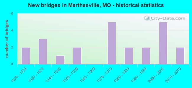
- New bridges - historical statistics
- 21920-1929
- 31930-1939
- 11940-1949
- 21950-1959
- 51970-1979
- 21980-1989
- 21990-1999
- 52000-2009
- 22010-2019


- Bridge Condition - Deck
- 6.7%Very good
- 53.3%Good
- 13.3%Satisfactory
- 26.7%Fair

- Bridge Condition - Superstructure
- 20.0%Excellent
- 13.3%Very good
- 20.0%Good
- 33.3%Satisfactory
- 13.3%Fair

- Bridge Condition - Substructure
- 26.7%Excellent
- 6.7%Very good
- 6.7%Good
- 46.7%Satisfactory
- 13.3%Fair

- Bridge Condition - Channel
- 4.2%Very good
- 16.7%Good
- 62.5%Satisfactory
- 16.7%Fair
Find on map >> Show street view
Structure Number: 16535, Location: S 27 T 45 N R 2 W (Lat: 38.632361, Lng: -91.123417), Route carried "on" structure: County highway 124, Year Built: 1971, Status: Posted for load, Structure Length: 1.10m (3.61ft), Average Daily Traffic: 30 (year 2020), Truck Traffic: 10%, Average Future Daily Traffic: 48 (year 2040), Features Intersected: KOCHS CR, Facility Carried by Structure: BOUEFF RD
Minimum Vertical Clearance: 30+ m (98+ ft), Kilometerpoint: 0.161, Lanes on structure: 2, Owner: County Highway Agency, Approaching Roadway Width: 7.6m (24.9ft), Material/Design: Steel continuous, Design/Construction: Stringer/Multi-beam, Number Of Spans In Main Unit: 2, Length of Maximum Span: 5.2m (17.1ft), Curb-To-Curb Width: 8.6m (28.2ft), Out-to-Out Width: 9.1m (29.9ft)
Condition: Deck: Satisfactory, Superstructure: Satisfactory, Substructure: Satisfactory, Channel: Fair, Operating Rating: 25.2 metric tons, Method Used To Determine Operating Rating: Allowable Stress (AS), Inventory Rating: 11.7 metric tons, Method Used To Determine Inventory Rating: Allowable Stress (AS), Structural Evaluation: Meets minimum limits, Deck Geometry: Better than present minimum criteria, Waterway Adequacy: Better than present minimum criteria, Approach Roadway Alignment: Equal to present desirable criteria, Designated Inspection Frequency: Every 24 months, Inspection Date: March 2022, Deck Structure Type: Concrete Cast-file-Place, Wearing Surface/Protective System: Wearing Surface: Gravel
Find on map >> Show street view
Structure Number: 16857, Location: S 10 T 45 N R 1 W (Lat: 38.664000, Lng: -91.019139), Route carried "on" structure: County highway 134, Year Built: 1988, Status: Open, Structure Length: 2.01m (6.59ft), Average Daily Traffic: 75 (year 2020), Truck Traffic: 10%, Average Future Daily Traffic: 120 (year 2040), Features Intersected: TOQUE CR, Facility Carried by Structure: JOERLING RD
Minimum Vertical Clearance: 30+ m (98+ ft), Kilometerpoint: 6.116, Lanes on structure: 2, Owner: County Highway Agency, Approaching Roadway Width: 6.7m (22.0ft), Material/Design: Steel, Design/Construction: Stringer/Multi-beam, Number Of Spans In Main Unit: 1, Length of Maximum Span: 19.8m (65.0ft), Curb-To-Curb Width: 7.1m (23.3ft), Out-to-Out Width: 7.3m (24.0ft)
Condition: Deck: Satisfactory, Superstructure: Fair, Substructure: Fair, Channel: Fair, Operating Rating: 62.1 metric tons, Method Used To Determine Operating Rating: Allowable Stress (AS), Inventory Rating: 39.6 metric tons, Method Used To Determine Inventory Rating: Allowable Stress (AS), Structural Evaluation: Somewhat better than minimum adequacy, Deck Geometry: Somewhat better than minimum adequacy, Waterway Adequacy: Somewhat better than minimum adequacy, Approach Roadway Alignment: Somewhat better than minimum adequacy, Designated Inspection Frequency: Every 24 months, Inspection Date: Febuary 2022, Deck Structure Type: Concrete Cast-file-Place
Find on map >> Show street view
Structure Number: 16901, Location: S 15 T 45 N R 1 W (Lat: 38.649694, Lng: -91.010056), Route carried "on" structure: County highway 136, Year Built: 1978, Status: Posted for load, Structure Length: 1.68m (5.51ft), Average Daily Traffic: 30 (year 2020), Truck Traffic: 10%, Average Future Daily Traffic: 48 (year 2040), Features Intersected: WOLF CR, Facility Carried by Structure: WOLF CREEK RD
Minimum Vertical Clearance: 30+ m (98+ ft), Kilometerpoint: 0.966, Lanes on structure: 1, Owner: County Highway Agency, Approaching Roadway Width: 5.2m (17.1ft), Skew: 3 degrees, Material/Design: Concrete continuous, Design/Construction: Slab, Number Of Spans In Main Unit: 10, Length of Maximum Span: 0.9m (3.0ft), Curb-To-Curb Width: 4.2m (13.8ft), Out-to-Out Width: 4.2m (13.8ft)
Condition: Deck: Fair, Superstructure: Satisfactory, Substructure: Satisfactory, Channel: Satisfactory, Operating Rating: 17.1 metric tons, Method Used To Determine Operating Rating: Allowable Stress (AS), Inventory Rating: 12.6 metric tons, Method Used To Determine Inventory Rating: Allowable Stress (AS), Structural Evaluation: Meets minimum limits, Deck Geometry: Somewhat better than minimum adequacy, Waterway Adequacy: Meets minimum limits, Approach Roadway Alignment: Equal to present minimum criteria, Bridge Posting: Required (Relationship of Operating Rating to Maximum Legal Load: 30.0 - 39.9% below), Designated Inspection Frequency: Every 24 months, Inspection Date: Febuary 2022, Deck Structure Type: Concrete Cast-file-Place
Find on map >> Show street view
Structure Number: 16957, Location: S 758 T 45 N R 1 W (Lat: 38.627139, Lng: -91.039444), Route carried "on" structure: County highway 138, Year Built: 1987, Status: Open, Structure Length: 2.36m (7.74ft), Average Daily Traffic: 750 (year 2020), Truck Traffic: 10%, Average Future Daily Traffic: 1,200 (year 2040), Features Intersected: TOQUE CR, Facility Carried by Structure: BOONE MONUMENT RD
Minimum Vertical Clearance: 30+ m (98+ ft), Kilometerpoint: 0.161, Lanes on structure: 2, Owner: County Highway Agency, Approaching Roadway Width: 7.3m (24.0ft), Material/Design: Steel, Design/Construction: Stringer/Multi-beam, Number Of Spans In Main Unit: 1, Length of Maximum Span: 22.6m (74.1ft), Curb-To-Curb Width: 7.2m (23.6ft), Out-to-Out Width: 7.3m (24.0ft)
Condition: Deck: Fair, Superstructure: Fair, Substructure: Satisfactory, Channel: Satisfactory, Operating Rating: 26.1 metric tons, Method Used To Determine Operating Rating: Load Factor (LF), Inventory Rating: 15.3 metric tons, Method Used To Determine Inventory Rating: Load Factor (LF), Structural Evaluation: Meets minimum limits, Deck Geometry: Meets minimum limits, Waterway Adequacy: Better than present minimum criteria, Approach Roadway Alignment: Equal to present minimum criteria, Designated Inspection Frequency: Every 24 months, Inspection Date: Febuary 2020, Deck Structure Type: Concrete Cast-file-Place
Find on map >> Show street view
Structure Number: 17516, Location: S 24 T 45 N R 2 W (Lat: 38.644944, Lng: -91.080833), Route carried "on" structure: County highway 155, Year Built: 1996, Status: Open, Structure Length: 0.98m (3.22ft), Average Daily Traffic: 15 (year 2020), Truck Traffic: 10%, Average Future Daily Traffic: 24 (year 2040), Features Intersected: BR OF CHARRETTE CR, Facility Carried by Structure: RIDDER RD
Minimum Vertical Clearance: 30+ m (98+ ft), Kilometerpoint: 0.322, Lanes on structure: 2, Owner: County Highway Agency, Approaching Roadway Width: 4.3m (14.1ft), Material/Design: Steel, Design/Construction: Stringer/Multi-beam, Number Of Spans In Main Unit: 1, Length of Maximum Span: 9.1m (29.9ft), Curb-To-Curb Width: 6.9m (22.6ft), Out-to-Out Width: 6.9m (22.6ft)
Condition: Deck: Good, Superstructure: Good, Substructure: Fair, Channel: Fair, Operating Rating: 78.3 metric tons, Method Used To Determine Operating Rating: Load Factor (LF), Inventory Rating: 46.8 metric tons, Method Used To Determine Inventory Rating: Load Factor (LF), Structural Evaluation: Somewhat better than minimum adequacy, Deck Geometry: Somewhat better than minimum adequacy, Waterway Adequacy: Equal to present minimum criteria, Approach Roadway Alignment: Equal to present desirable criteria, Designated Inspection Frequency: Every 24 months, Inspection Date: Febuary 2022, Deck Structure Type: Concrete Cast-file-Place
Find on map >> Show street view
Structure Number: 20653, Location: S 29 T 45 N R 1 W (Lat: 38.627806, Lng: -91.060111), Route carried "on" structure: City street , Year Built: 2000, Status: Open, Structure Length: 1.46m (4.79ft), Average Daily Traffic: 1,125 (year 2020), Truck Traffic: 10%, Average Future Daily Traffic: 1,800 (year 2040), Design Load: HS 20, Features Intersected: TRIB OF TOQUE CR, Facility Carried by Structure: ONE ST/ RTE D
Minimum Vertical Clearance: 30+ m (98+ ft), Kilometerpoint: 0.161, Lanes on structure: 2, Owner: County Highway Agency, Maintenance Responsibility: Town or Township Highway Agency, Approaching Roadway Width: 7.3m (24.0ft), Skew: 4 degrees, Material/Design: Concrete continuous, Design/Construction: Culvert, Number Of Spans In Main Unit: 3, Length of Maximum Span: 4.6m (15.1ft), Curb or Sidewalk Widths: Left: 0.5m (1.6ft), Right: 0.5m (1.6ft), Curb-To-Curb Width: 8.2m (26.9ft), Out-to-Out Width: 9.2m (30.2ft)
Condition: Channel: Satisfactory, Culverts: Satisfactory, Operating Rating: 50.4 metric tons, Method Used To Determine Operating Rating: Load Factor (LF), Inventory Rating: 30.6 metric tons, Method Used To Determine Inventory Rating: Load Factor (LF), Structural Evaluation: Equal to present minimum criteria, Deck Geometry: Meets minimum limits, Waterway Adequacy: Somewhat better than minimum adequacy, Approach Roadway Alignment: Equal to present desirable criteria, Designated Inspection Frequency: Every 24 months, Inspection Date: Febuary 2022
Find on map >> Show street view
Structure Number: 2679, Location: S 27 T 45 N R 2 W (Lat: 38.633344, Lng: -91.125850), Route carried "on" structure: State highway 94, Year Built: 1975, Status: Open, Structure Length: 0.65m (2.13ft), Average Daily Traffic: 1,474 (year 2021), Truck Traffic: 11%, Average Future Daily Traffic: 2,948 (year 2041), Design Load: H 15, Features Intersected: PEERS CR
Minimum Vertical Clearance: 30+ m (98+ ft), Kilometerpoint: 108.468, Lanes on structure: 2, Owner: State Highway Agency, Approaching Roadway Width: 12.8m (42.0ft), Skew: 1 degrees, Material/Design: Concrete continuous, Design/Construction: Culvert, Number Of Spans In Main Unit: 2, Length of Maximum Span: 3.0m (9.8ft), Curb-To-Curb Width: 13.9m (45.6ft), Out-to-Out Width: 14.5m (47.6ft)
Condition: Channel: Satisfactory, Culverts: Satisfactory, Inventory Rating: 77.4 metric tons, Method Used To Determine Inventory Rating: Load Factor (LF), Structural Evaluation: Equal to present minimum criteria, Deck Geometry: Superior to present desirable criteria, Waterway Adequacy: Equal to present desirable criteria, Approach Roadway Alignment: Equal to present desirable criteria, Designated Inspection Frequency: Every 24 months, Inspection Date: November 2020
Find on map >> Show street view
Structure Number: 268, Location: S 873 T 45 N R 1 W (Lat: 38.627150, Lng: -91.074992), Route carried "on" structure: State highway 94, Year Built: 1979, Status: Open, Structure Length: 13.53m (44.39ft), Average Daily Traffic: 1,474 (year 2021), Truck Traffic: 11%, Average Future Daily Traffic: 2,948 (year 2041), Design Load: H 15, Features Intersected: CHARRETTE CR
Minimum Vertical Clearance: 30+ m (98+ ft), Kilometerpoint: 113.111, Lanes on structure: 2, Owner: State Highway Agency, Approaching Roadway Width: 6.1m (20.0ft), Skew: 4 degrees, Material/Design: Steel continuous, Design/Construction: Stringer/Multi-beam, Number Of Spans In Main Unit: 3, Number Of Approach Spans: 3, Length of Maximum Span: 39.3m (128.9ft), Curb or Sidewalk Widths: Left: 0.2m (0.7ft), Right: 0.2m (0.7ft), Curb-To-Curb Width: 10.4m (34.1ft), Out-to-Out Width: 11.0m (36.1ft)
Condition: Deck: Good, Superstructure: Very good, Substructure: Satisfactory, Channel: Good, Operating Rating: 35.1 metric tons, Method Used To Determine Operating Rating: Load Factor (LF), Inventory Rating: 20.7 metric tons, Method Used To Determine Inventory Rating: Load Factor (LF), Structural Evaluation: Somewhat better than minimum adequacy, Deck Geometry: Equal to present minimum criteria, Waterway Adequacy: Equal to present desirable criteria, Approach Roadway Alignment: Equal to present desirable criteria, Designated Inspection Frequency: Every 24 months, Other Special Inspection Frequency: Every 24 months, Inspection Date: October 2020, Other Special Inspection Date: October 2020, Deck Structure Type: Concrete Cast-file-Place, Wearing Surface/Protective System: Wearing Surface: Epoxy Overlay, Deck Protection: Epoxy Coated Reinforcing
Find on map >> Show street view
Structure Number: 297, Location: S 26 T 45 N R 2 W (Lat: 38.631181, Lng: -91.112514), Route carried "on" structure: State highway 94, Year Built: 1973, Status: Open, Structure Length: 0.98m (3.22ft), Average Daily Traffic: 1,474 (year 2021), Truck Traffic: 11%, Average Future Daily Traffic: 2,948 (year 2041), Design Load: H 15, Features Intersected: DIVERSION OF PEERS
Minimum Vertical Clearance: 30+ m (98+ ft), Kilometerpoint: 109.663, Lanes on structure: 2, Owner: State Highway Agency, Approaching Roadway Width: 7.9m (25.9ft), Skew: 4 degrees, Material/Design: Concrete continuous, Design/Construction: Culvert, Number Of Spans In Main Unit: 2, Length of Maximum Span: 3.4m (11.2ft)
Condition: Channel: Satisfactory, Culverts: Satisfactory, Inventory Rating: 64.8 metric tons, Method Used To Determine Inventory Rating: Load Factor (LF), Structural Evaluation: Equal to present minimum criteria, Waterway Adequacy: Equal to present desirable criteria, Approach Roadway Alignment: Equal to present desirable criteria, Designated Inspection Frequency: Every 24 months, Inspection Date: November 2020
Find on map >> Show street view
Structure Number: 30819, Location: S 873 T 45 N R 1 W (Lat: 38.634028, Lng: -91.067861), Route carried "on" structure: County highway 156, Year Built: 2004, Status: Open, Structure Length: 0.92m (3.02ft), Average Daily Traffic: 35 (year 2020), Truck Traffic: 10%, Average Future Daily Traffic: 56 (year 2040), Features Intersected: BRANCH, Facility Carried by Structure: TOWN BRANCH RD
Minimum Vertical Clearance: 30+ m (98+ ft), Kilometerpoint: 0.161, Lanes on structure: 2, Owner: County Highway Agency, Approaching Roadway Width: 6.7m (22.0ft), Material/Design: Steel, Design/Construction: Stringer/Multi-beam, Number Of Spans In Main Unit: 1, Length of Maximum Span: 8.6m (28.2ft), Curb-To-Curb Width: 7.9m (25.9ft), Out-to-Out Width: 7.9m (25.9ft)
Condition: Deck: Good, Superstructure: Satisfactory, Substructure: Satisfactory, Channel: Satisfactory, Inventory Rating: 64.8 metric tons, Method Used To Determine Inventory Rating: Load Factor (LF), Structural Evaluation: Equal to present minimum criteria, Deck Geometry: Equal to present minimum criteria, Waterway Adequacy: Better than present minimum criteria, Approach Roadway Alignment: Equal to present desirable criteria, Designated Inspection Frequency: Every 24 months, Inspection Date: Febuary 2022, Deck Structure Type: Concrete Cast-file-Place
Find on map >> Show street view
Structure Number: 31825, Location: S 10 T 45 N R 2 W (Lat: 38.665083, Lng: -91.123278), Route carried "on" structure: County highway 122, Year Built: 2007, Status: Open, Structure Length: 3.90m (12.80ft), Average Daily Traffic: 250 (year 2020), Truck Traffic: 10%, Average Future Daily Traffic: 400 (year 2040), Design Load: HS 20, Features Intersected: DRY FK, Facility Carried by Structure: CONCORD HILL RD
Minimum Vertical Clearance: 30+ m (98+ ft), Kilometerpoint: 1.287, Lanes on structure: 2, Owner: County Highway Agency, Approaching Roadway Width: 7.3m (24.0ft), Skew: 2 degrees, Material/Design: Prestressed concrete continuous, Design/Construction: Stringer/Multi-beam, Number Of Spans In Main Unit: 3, Length of Maximum Span: 15.2m (49.9ft), Curb-To-Curb Width: 7.9m (25.9ft), Out-to-Out Width: 8.1m (26.6ft)
Condition: Deck: Good, Superstructure: Excellent, Substructure: Excellent, Channel: Satisfactory, Operating Rating: 78.3 metric tons, Method Used To Determine Operating Rating: Load Factor (LF), Inventory Rating: 46.8 metric tons, Method Used To Determine Inventory Rating: Load Factor (LF), Structural Evaluation: Superior to present desirable criteria, Deck Geometry: Somewhat better than minimum adequacy, Waterway Adequacy: Equal to present minimum criteria, Approach Roadway Alignment: Equal to present desirable criteria, Designated Inspection Frequency: Every 24 months, Inspection Date: Febuary 2022, Deck Structure Type: Concrete Cast-file-Place, Wearing Surface/Protective System: Wearing Surface: Integral Concrete
Find on map >> Show street view
Structure Number: 32072, Location: S 12 T 45 N R 2 W (Lat: 38.676778, Lng: -91.089944), Route carried "on" structure: County highway 131, Year Built: 2008, Status: Open, Structure Length: 4.57m (14.99ft), Average Daily Traffic: 40 (year 2020), Truck Traffic: 25%, Average Future Daily Traffic: 64 (year 2040), Design Load: HS 20, Features Intersected: CHARRETTE CR, Facility Carried by Structure: CHARRETTE CR RD
Minimum Vertical Clearance: 30+ m (98+ ft), Kilometerpoint: 3.058, Lanes on structure: 2, Owner: County Highway Agency, Approaching Roadway Width: 5.5m (18.0ft), Skew: 1 degrees, Material/Design: Prestressed concrete continuous, Design/Construction: Stringer/Multi-beam, Number Of Spans In Main Unit: 3, Length of Maximum Span: 21.3m (69.9ft), Curb-To-Curb Width: 7.9m (25.9ft), Out-to-Out Width: 8.1m (26.6ft)
Condition: Deck: Very good, Superstructure: Good, Substructure: Very good, Channel: Good, Operating Rating: 54.9 metric tons, Method Used To Determine Operating Rating: Load Factor (LF), Inventory Rating: 33.3 metric tons, Method Used To Determine Inventory Rating: Load Factor (LF), Structural Evaluation: Better than present minimum criteria, Deck Geometry: Equal to present minimum criteria, Waterway Adequacy: Somewhat better than minimum adequacy, Approach Roadway Alignment: Better than present minimum criteria, Designated Inspection Frequency: Every 24 months, Inspection Date: Febuary 2022, Deck Structure Type: Concrete Cast-file-Place, Wearing Surface/Protective System: Wearing Surface: Monolithic Concrete
Find on map >> Show street view
Structure Number: 32202, Location: S 1 T 45 N R 2 W (Lat: 38.677611, Lng: -91.089583), Route carried "on" structure: County highway 131, Year Built: 2007, Status: Open, Structure Length: 1.10m (3.61ft), Average Daily Traffic: 40 (year 2020), Truck Traffic: 10%, Average Future Daily Traffic: 64 (year 2040), Features Intersected: BR OF CHARRETTE CR, Facility Carried by Structure: CHARRETTE CR RD
Minimum Vertical Clearance: 30+ m (98+ ft), Kilometerpoint: 3.219, Lanes on structure: 2, Owner: County Highway Agency, Approaching Roadway Width: 7.3m (24.0ft), Material/Design: Steel, Design/Construction: Stringer/Multi-beam, Number Of Spans In Main Unit: 1, Length of Maximum Span: 10.7m (35.1ft), Curb-To-Curb Width: 7.9m (25.9ft), Out-to-Out Width: 8.1m (26.6ft)
Condition: Deck: Good, Superstructure: Good, Substructure: Good, Channel: Satisfactory, Inventory Rating: 77.4 metric tons, Method Used To Determine Inventory Rating: Load Factor (LF), Structural Evaluation: Better than present minimum criteria, Deck Geometry: Equal to present minimum criteria, Waterway Adequacy: Better than present minimum criteria, Approach Roadway Alignment: Equal to present desirable criteria, Designated Inspection Frequency: Every 24 months, Inspection Date: Febuary 2022, Deck Structure Type: Concrete Cast-file-Place
Find on map >> Show street view
Structure Number: 33479, Location: S 33 T 45 N R 1 W (Lat: 38.617694, Lng: -91.044347), Route carried "on" structure: State highway 47, Year Built: 2011, Status: Open, Structure Length: 5.21m (17.09ft), Average Daily Traffic: 4,334 (year 2021), Truck Traffic: 11%, Average Future Daily Traffic: 8,668 (year 2041), Features Intersected: TUQUE CR
Minimum Vertical Clearance: 30+ m (98+ ft), Kilometerpoint: 81.776, Lanes on structure: 2, Base Highway Network: Yes, Owner: State Highway Agency, Approaching Roadway Width: 9.8m (32.2ft), Material/Design: Prestressed concrete continuous, Design/Construction: Stringer/Multi-beam, Number Of Spans In Main Unit: 3, Length of Maximum Span: 21.6m (70.9ft), Curb-To-Curb Width: 9.8m (32.2ft), Out-to-Out Width: 10.6m (34.8ft)
Condition: Deck: Good, Superstructure: Excellent, Substructure: Excellent, Channel: Good, Operating Rating: 73.8 metric tons, Method Used To Determine Operating Rating: Load Factor (LF), Inventory Rating: 39.6 metric tons, Method Used To Determine Inventory Rating: Load Factor (LF), Structural Evaluation: Superior to present desirable criteria, Deck Geometry: Meets minimum limits, Waterway Adequacy: Superior to present desirable criteria, Approach Roadway Alignment: Equal to present desirable criteria, Designated Inspection Frequency: Every 48 months, Inspection Date: November 2020, Deck Structure Type: Concrete Cast-file-Place, Wearing Surface/Protective System: Wearing Surface: Monolithic Concrete, Deck Protection: Epoxy Coated Reinforcing
Find on map >> Show street view
Structure Number: 34125, Location: S 21 T 45 N R 1 W (Lat: 38.641822, Lng: -91.023256), Route carried "on" structure: State highway D, Year Built: 2012, Status: Open, Structure Length: 2.49m (8.17ft), Average Daily Traffic: 1,766 (year 2021), Truck Traffic: 8%, Average Future Daily Traffic: 3,532 (year 2041), Design Load: HS 20, Features Intersected: BR OF TUQUE CR
Minimum Vertical Clearance: 30+ m (98+ ft), Kilometerpoint: 4.612, Lanes on structure: 2, Owner: State Highway Agency, Approaching Roadway Width: 7.3m (24.0ft), Skew: 3 degrees, Material/Design: Prestressed concrete, Design/Construction: Box Beam or Girders - Single/Spread, Number Of Spans In Main Unit: 1, Length of Maximum Span: 24.4m (80.1ft), Curb-To-Curb Width: 7.3m (24.0ft), Out-to-Out Width: 7.9m (25.9ft)
Condition: Deck: Good, Superstructure: Excellent, Substructure: Excellent, Channel: Very good, Operating Rating: 91.8 metric tons, Method Used To Determine Operating Rating: Load Factor (LF), Inventory Rating: 42.3 metric tons, Method Used To Determine Inventory Rating: Load Factor (LF), Structural Evaluation: Superior to present desirable criteria, Deck Geometry: Meets minimum limits, Waterway Adequacy: Superior to present desirable criteria, Approach Roadway Alignment: Equal to present desirable criteria, Designated Inspection Frequency: Every 48 months, Inspection Date: November 2020, Deck Structure Type: Concrete Cast-file-Place, Wearing Surface/Protective System: Wearing Surface: Monolithic Concrete, Deck Protection: Epoxy Coated Reinforcing
Find on map >> Show street view
Structure Number: 4276, Location: S 14 T 45 N R 2 W (Lat: 38.658622, Lng: -91.104072), Route carried "on" structure: State highway 47, Year Built: 1995, Status: Open, Structure Length: 9.78m (32.09ft), Average Daily Traffic: 2,121 (year 2021), Truck Traffic: 11%, Average Future Daily Traffic: 4,242 (year 2041), Design Load: HS 20, Features Intersected: CHARRETTE CR
Minimum Vertical Clearance: 30+ m (98+ ft), Kilometerpoint: 74.304, Lanes on structure: 2, Base Highway Network: Yes, Owner: State Highway Agency, Approaching Roadway Width: 12.2m (40.0ft), Material/Design: Prestressed concrete continuous, Design/Construction: Stringer/Multi-beam, Number Of Spans In Main Unit: 5, Length of Maximum Span: 23.2m (76.1ft), Curb or Sidewalk Widths: Left: 0.2m (0.7ft), Right: 0.2m (0.7ft), Curb-To-Curb Width: 11.8m (38.7ft), Out-to-Out Width: 12.6m (41.3ft)
Condition: Deck: Good, Superstructure: Very good, Substructure: Excellent, Channel: Good, Operating Rating: 65.7 metric tons, Method Used To Determine Operating Rating: Load Factor (LF), Inventory Rating: 39.6 metric tons, Method Used To Determine Inventory Rating: Load Factor (LF), Structural Evaluation: Equal to present desirable criteria, Deck Geometry: Somewhat better than minimum adequacy, Waterway Adequacy: Equal to present desirable criteria, Approach Roadway Alignment: Better than present minimum criteria, Designated Inspection Frequency: Every 24 months, Inspection Date: November 2020, Deck Structure Type: Concrete Cast-file-Place, Wearing Surface/Protective System: Wearing Surface: Monolithic Concrete, Deck Protection: Epoxy Coated Reinforcing
Find on map >> Show street view
Structure Number: 5042, Location: S 169 T 45 N R 2 W (Lat: 38.695339, Lng: -91.140278), Route carried "on" structure: State highway 47, Year Built: 1931, Status: Open, Structure Length: 1.28m (4.20ft), Average Daily Traffic: 3,063 (year 2021), Truck Traffic: 26%, Average Future Daily Traffic: 6,126 (year 2041), Design Load: H 15, Features Intersected: HOPEWELL CR
Minimum Vertical Clearance: 30+ m (98+ ft), Kilometerpoint: 68.991, Lanes on structure: 2, Base Highway Network: Yes, Owner: State Highway Agency, Approaching Roadway Width: 9.1m (29.9ft), Skew: 2 degrees, Material/Design: Concrete continuous, Design/Construction: Culvert, Number Of Spans In Main Unit: 3, Length of Maximum Span: 3.7m (12.1ft), Curb-To-Curb Width: 10.5m (34.4ft), Out-to-Out Width: 11.1m (36.4ft)
Condition: Channel: Satisfactory, Culverts: Satisfactory, Operating Rating: 70.2 metric tons, Method Used To Determine Operating Rating: Load Factor (LF), Inventory Rating: 42.3 metric tons, Method Used To Determine Inventory Rating: Load Factor (LF), Structural Evaluation: Equal to present minimum criteria, Deck Geometry: Somewhat better than minimum adequacy, Waterway Adequacy: Equal to present desirable criteria, Approach Roadway Alignment: Equal to present desirable criteria, Designated Inspection Frequency: Every 24 months, Inspection Date: November 2020
Find on map >> Show street view
Structure Number: 5043, Location: S 10 T 45 N R 2 W (Lat: 38.680956, Lng: -91.132903), Route carried "on" structure: State highway 47, Year Built: 1931, Status: Open, Structure Length: 0.64m (2.10ft), Average Daily Traffic: 2,121 (year 2021), Truck Traffic: 11%, Average Future Daily Traffic: 4,242 (year 2041), Design Load: H 15, Features Intersected: SCHOOL CR
Minimum Vertical Clearance: 30+ m (98+ ft), Kilometerpoint: 70.814, Lanes on structure: 2, Base Highway Network: Yes, Owner: State Highway Agency, Approaching Roadway Width: 9.1m (29.9ft), Material/Design: Concrete continuous, Design/Construction: Culvert, Number Of Spans In Main Unit: 2, Length of Maximum Span: 3.0m (9.8ft), Curb-To-Curb Width: 11.0m (36.1ft), Out-to-Out Width: 11.6m (38.1ft)
Condition: Channel: Satisfactory, Culverts: Satisfactory, Operating Rating: 72.0 metric tons, Method Used To Determine Operating Rating: Load Factor (LF), Inventory Rating: 43.2 metric tons, Method Used To Determine Inventory Rating: Load Factor (LF), Structural Evaluation: Equal to present minimum criteria, Deck Geometry: Somewhat better than minimum adequacy, Waterway Adequacy: Equal to present desirable criteria, Approach Roadway Alignment: Equal to present minimum criteria, Designated Inspection Frequency: Every 24 months, Inspection Date: November 2020
Find on map >> Show street view
Structure Number: 5044, Location: S 10 T 45 N R 2 W (Lat: 38.671414, Lng: -91.122269), Route carried "on" structure: State highway 47, Year Built: 1931, Status: Open, Structure Length: 0.64m (2.10ft), Average Daily Traffic: 2,121 (year 2021), Truck Traffic: 11%, Average Future Daily Traffic: 4,242 (year 2041), Design Load: H 15, Features Intersected: BUESCHER CR
Minimum Vertical Clearance: 30+ m (98+ ft), Kilometerpoint: 72.223, Lanes on structure: 2, Base Highway Network: Yes, Owner: State Highway Agency, Approaching Roadway Width: 9.1m (29.9ft), Material/Design: Concrete continuous, Design/Construction: Culvert, Number Of Spans In Main Unit: 2, Length of Maximum Span: 3.0m (9.8ft), Curb-To-Curb Width: 11.1m (36.4ft), Out-to-Out Width: 11.7m (38.4ft)
Condition: Channel: Satisfactory, Culverts: Satisfactory, Operating Rating: 72.0 metric tons, Method Used To Determine Operating Rating: Load Factor (LF), Inventory Rating: 43.2 metric tons, Method Used To Determine Inventory Rating: Load Factor (LF), Structural Evaluation: Equal to present minimum criteria, Deck Geometry: Somewhat better than minimum adequacy, Waterway Adequacy: Equal to present minimum criteria, Approach Roadway Alignment: Equal to present desirable criteria, Designated Inspection Frequency: Every 24 months, Inspection Date: November 2020
Find on map >> Show street view
Structure Number: 5045, Location: S 24 T 45 N R 2 W (Lat: 38.662964, Lng: -91.080881), Route carried "on" structure: State highway 47, Year Built: 1928, Status: Open, Structure Length: 0.84m (2.76ft), Average Daily Traffic: 2,121 (year 2021), Truck Traffic: 11%, Average Future Daily Traffic: 4,242 (year 2041), Design Load: H 15, Features Intersected: TIMBER CR
Minimum Vertical Clearance: 30+ m (98+ ft), Kilometerpoint: 76.838, Lanes on structure: 2, Base Highway Network: Yes, Owner: State Highway Agency, Approaching Roadway Width: 9.1m (29.9ft), Skew: 2 degrees, Material/Design: Concrete continuous, Design/Construction: Culvert, Number Of Spans In Main Unit: 2, Length of Maximum Span: 3.7m (12.1ft), Curb-To-Curb Width: 11.9m (39.0ft), Out-to-Out Width: 12.5m (41.0ft)
Condition: Channel: Fair, Culverts: Satisfactory, Inventory Rating: 66.6 metric tons, Method Used To Determine Inventory Rating: Load Factor (LF), Structural Evaluation: Equal to present minimum criteria, Deck Geometry: Somewhat better than minimum adequacy, Waterway Adequacy: Equal to present desirable criteria, Approach Roadway Alignment: Equal to present desirable criteria, Designated Inspection Frequency: Every 24 months, Inspection Date: November 2020
Find on map >> Show street view
Structure Number: 5148, Location: S 873 T 45 N R 1 W (Lat: 38.631244, Lng: -91.065511), Route carried "on" structure: State highway 47, Year Built: 1928, Status: Open, Structure Length: 0.76m (2.49ft), Average Daily Traffic: 2,382 (year 2021), Truck Traffic: 11%, Average Future Daily Traffic: 4,764 (year 2041), Design Load: H 15, Features Intersected: SANDY CR
Minimum Vertical Clearance: 30+ m (98+ ft), Kilometerpoint: 78.679, Lanes on structure: 2, Base Highway Network: Yes, Owner: State Highway Agency, Approaching Roadway Width: 9.1m (29.9ft), Material/Design: Concrete continuous, Design/Construction: Culvert, Number Of Spans In Main Unit: 2, Length of Maximum Span: 3.7m (12.1ft), Curb-To-Curb Width: 10.4m (34.1ft), Out-to-Out Width: 11.0m (36.1ft)
Condition: Channel: Satisfactory, Culverts: Satisfactory, Operating Rating: 68.4 metric tons, Method Used To Determine Operating Rating: Load Factor (LF), Inventory Rating: 41.4 metric tons, Method Used To Determine Inventory Rating: Load Factor (LF), Structural Evaluation: Equal to present minimum criteria, Deck Geometry: Somewhat better than minimum adequacy, Waterway Adequacy: Equal to present desirable criteria, Approach Roadway Alignment: Equal to present desirable criteria, Designated Inspection Frequency: Every 24 months, Inspection Date: November 2020
Find on map >> Show street view
Structure Number: 6904, Location: S 21 T 45 N R 1 W (Lat: 38.642744, Lng: -91.019347), Route carried "on" structure: State highway D, Year Built: 1958, Status: Posted for load, Structure Length: 4.51m (14.80ft), Average Daily Traffic: 1,766 (year 2021), Truck Traffic: 8%, Average Future Daily Traffic: 3,532 (year 2041), Design Load: H 10, Features Intersected: TUQUE & WOLF CR
Minimum Vertical Clearance: 30+ m (98+ ft), Kilometerpoint: 4.981, Lanes on structure: 2, Owner: State Highway Agency, Approaching Roadway Width: 6.1m (20.0ft), Material/Design: Concrete, Design/Construction: Tee Beam, Number Of Spans In Main Unit: 3, Length of Maximum Span: 16.0m (52.5ft), Curb-To-Curb Width: 6.1m (20.0ft), Out-to-Out Width: 7.1m (23.3ft)
Condition: Deck: Fair, Superstructure: Satisfactory, Substructure: Satisfactory, Channel: Satisfactory, Operating Rating: 24.3 metric tons, Method Used To Determine Operating Rating: Allowable Stress (AS), Inventory Rating: 11.7 metric tons, Method Used To Determine Inventory Rating: Allowable Stress (AS), Structural Evaluation: High priority of replacement, Deck Geometry: High priority of replacement, Waterway Adequacy: Equal to present desirable criteria, Approach Roadway Alignment: Meets minimum limits, Bridge Posting: Required (Relationship of Operating Rating to Maximum Legal Load: 10.0 - 19.9% below), Length Of Structure Improvement: 0.55m (1.80ft), Designated Inspection Frequency: Every 24 months, Inspection Date: November 2020, Bridge Improvement Cost: $691,000, Roadway Improvement Cost: $69,000, Total Project Cost: $1,037,000 ( Estimate for 2022), Deck Structure Type: Concrete Cast-file-Place, Wearing Surface/Protective System: Wearing Surface: Bituminous
Find on map >> Show street view
Structure Number: 6905, Location: S 22 T 45 N R 1 W (Lat: 38.645547, Lng: -91.011819), Route carried "on" structure: State highway D, Year Built: 1958, Status: Open, Structure Length: 1.10m (3.61ft), Average Daily Traffic: 1,766 (year 2021), Truck Traffic: 8%, Average Future Daily Traffic: 3,532 (year 2041), Design Load: H 10, Features Intersected: COLLEGE CR
Minimum Vertical Clearance: 30+ m (98+ ft), Kilometerpoint: 5.792, Lanes on structure: 2, Owner: State Highway Agency, Approaching Roadway Width: 7.3m (24.0ft), Skew: 3 degrees, Material/Design: Concrete continuous, Design/Construction: Culvert, Number Of Spans In Main Unit: 3, Length of Maximum Span: 3.0m (9.8ft), Curb-To-Curb Width: 7.6m (24.9ft), Out-to-Out Width: 8.2m (26.9ft)
Condition: Channel: Satisfactory, Culverts: Satisfactory, Operating Rating: 45.9 metric tons, Method Used To Determine Operating Rating: Load Factor (LF), Inventory Rating: 27.9 metric tons, Method Used To Determine Inventory Rating: Load Factor (LF), Structural Evaluation: Equal to present minimum criteria, Deck Geometry: Meets minimum limits, Waterway Adequacy: Equal to present minimum criteria, Approach Roadway Alignment: Equal to present minimum criteria, Designated Inspection Frequency: Every 24 months, Inspection Date: November 2020
Find on map >> Show street view
Structure Number: 9423, Location: S 758 T 45 N R 1 W (Lat: 38.635336, Lng: -91.031161), Route carried "on" structure: State highway D, Year Built: 1940, Status: Posted for load, Structure Length: 0.58m (1.90ft), Average Daily Traffic: 1,766 (year 2021), Truck Traffic: 8%, Average Future Daily Traffic: 3,532 (year 2041), Design Load: H 10, Features Intersected: BR OF TUQUE CR
Minimum Vertical Clearance: 30+ m (98+ ft), Kilometerpoint: 3.619, Lanes on structure: 1, Owner: State Highway Agency, Approaching Roadway Width: 6.1m (20.0ft), Material/Design: Steel, Design/Construction: Stringer/Multi-beam, Number Of Spans In Main Unit: 1, Length of Maximum Span: 5.5m (18.0ft), Curb-To-Curb Width: 5.2m (17.1ft), Out-to-Out Width: 5.5m (18.0ft)
Condition: Deck: Fair, Superstructure: Satisfactory, Substructure: Satisfactory, Channel: Satisfactory, Operating Rating: 17.1 metric tons, Method Used To Determine Operating Rating: Load Factor (LF), Inventory Rating: 9.9 metric tons, Method Used To Determine Inventory Rating: Load Factor (LF), Structural Evaluation: High priority of corrective action, Deck Geometry: High priority of replacement, Waterway Adequacy: Equal to present minimum criteria, Approach Roadway Alignment: Meets minimum limits, Bridge Posting: Required (Relationship of Operating Rating to Maximum Legal Load: > 39.9% below), Designated Inspection Frequency: Every 24 months, Inspection Date: November 2020, Deck Structure Type: Concrete Cast-file-Place, Wearing Surface/Protective System: Wearing Surface: Bituminous, Membrane: Built-up