Bridge Statistics for Martinsville, Virginia (VA)
Condition, Traffic, Stress, Structural Evaluation, Project Costs
- National Bridge Inventory (NBI) Statistics
- 29Number of bridges
- 289ft / 87.7mTotal length
- $58,106,000Total costs
- 179,958Total average daily traffic
- 7,700Total average daily truck traffic
- National Bridge Inventory (NBI) Registered Bridges for Martinsville
- No street view available for this location
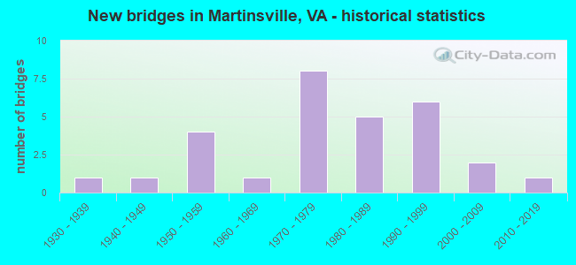
- New bridges - historical statistics
- 11930-1939
- 11940-1949
- 41950-1959
- 11960-1969
- 81970-1979
- 51980-1989
- 61990-1999
- 22000-2009
- 12010-2019
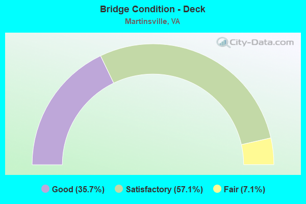
- Bridge Condition - Deck
- 35.7%Good
- 57.1%Satisfactory
- 7.1%Fair
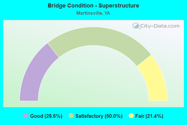
- Bridge Condition - Superstructure
- 28.6%Good
- 50.0%Satisfactory
- 21.4%Fair
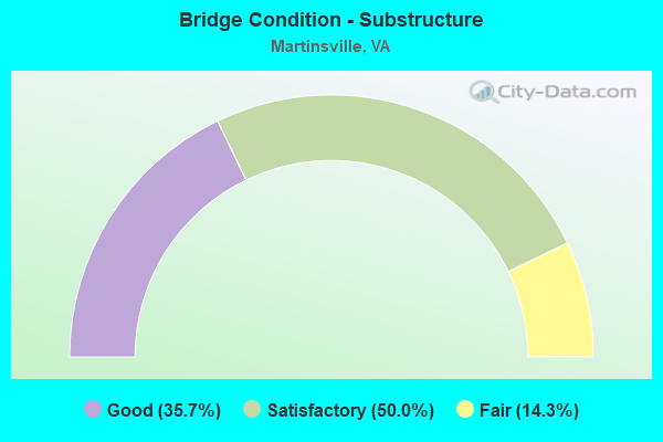
- Bridge Condition - Substructure
- 35.7%Good
- 50.0%Satisfactory
- 14.3%Fair
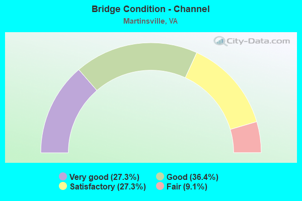
- Bridge Condition - Channel
- 27.3%Very good
- 36.4%Good
- 27.3%Satisfactory
- 9.1%Fair
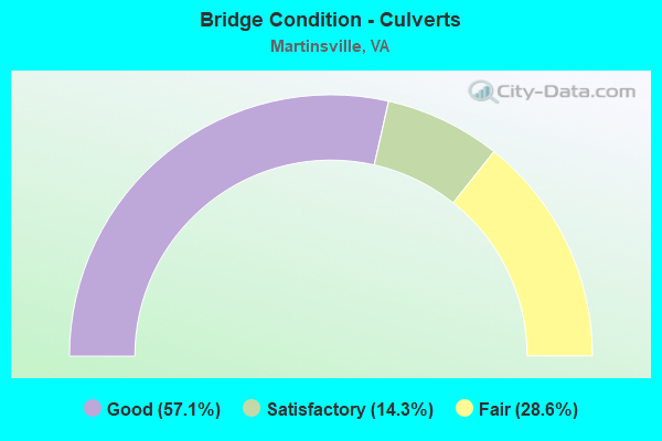
- Bridge Condition - Culverts
- 57.1%Good
- 14.3%Satisfactory
- 28.6%Fair
Find on map >> Show street view
Structure Number: 10038, Location: 0.70-SCL-MART;2.36-220 BP (Lat: 36.660958, Lng: -79.882125), Route carried "on" structure: Business US 58, Year Built: 1959, Status: Open, Structure Length: 5.79m (19.00ft), Average Daily Traffic: 8,397 (year 2018), Truck Traffic: 2%, Average Future Daily Traffic: 16,794 (year 2038), Design Load: HS 15, Features Intersected: 58 Business
Minimum Vertical Clearance: 4.57m (14.99ft), Kilometerpoint: 3.837, Lanes on structure: 5, Lanes under structure: 2, Base Highway Network: Yes, Owner: State Highway Agency, Approaching Roadway Width: 23.2m (76.1ft), Skew: 23 degrees, Material/Design: Steel, Design/Construction: Stringer/Multi-beam, Number Of Spans In Main Unit: 3, Length of Maximum Span: 24.4m (80.1ft), Curb or Sidewalk Widths: Left: 0.5m (1.6ft), Right: 0.5m (1.6ft), Curb-To-Curb Width: 19.5m (64.0ft), Out-to-Out Width: 22.3m (73.2ft)
Condition: Deck: Fair, Superstructure: Satisfactory, Substructure: Satisfactory, Operating Rating: 49.0 metric tons, Method Used To Determine Operating Rating: Load and Resistance Factor (LRFR), Inventory Rating: 37.2 metric tons, Method Used To Determine Inventory Rating: Load and Resistance Factor (LRFR), Structural Evaluation: Equal to present minimum criteria, Deck Geometry: Meets minimum limits, Underclear: Meets minimum limits, Approach Roadway Alignment: Better than present minimum criteria, Designated Inspection Frequency: Every 24 months, Inspection Date: March 2020, Deck Structure Type: Concrete Cast-file-Place, Wearing Surface/Protective System: Wearing Surface: Latex Concrete
Find on map >> Show street view
Structure Number: 1004, Location: 0.56 Martsvl; 0.09 Rt 220 (Lat: 36.663311, Lng: -79.882522), Route carried "on" structure: Business US 58, Year Built: 1959, Status: Open, Structure Length: 15.33m (50.30ft), Average Daily Traffic: 7,820 (year 2020), Truck Traffic: 2%, Average Future Daily Traffic: 10,948 (year 2040), Design Load: HS 15, Features Intersected: Smith River
Minimum Vertical Clearance: 30+ m (98+ ft), Kilometerpoint: 4.127, Lanes on structure: 2, Base Highway Network: Yes, Owner: State Highway Agency, Approaching Roadway Width: 7.3m (24.0ft), Skew: 2 degrees, Material/Design: Steel, Design/Construction: Stringer/Multi-beam, Number Of Spans In Main Unit: 8, Length of Maximum Span: 18.7m (61.4ft), Curb or Sidewalk Widths: Left: 1.5m (4.9ft), Right: 0.5m (1.6ft), Curb-To-Curb Width: 8.5m (27.9ft), Out-to-Out Width: 11.1m (36.4ft)
Condition: Deck: Satisfactory, Superstructure: Fair, Substructure: Fair, Channel: Good, Operating Rating: 42.6 metric tons, Method Used To Determine Operating Rating: Load and Resistance Factor (LRFR), Inventory Rating: 32.7 metric tons, Method Used To Determine Inventory Rating: Load and Resistance Factor (LRFR), Structural Evaluation: Somewhat better than minimum adequacy, Deck Geometry: High priority of corrective action, Waterway Adequacy: Superior to present desirable criteria, Approach Roadway Alignment: Somewhat better than minimum adequacy, Length Of Structure Improvement: 15.33m (50.30ft), Designated Inspection Frequency: Every 24 months, Inspection Date: March 2021, Bridge Improvement Cost: $9,153,000, Roadway Improvement Cost: $2,746,000, Total Project Cost: $29,290,000 ( Estimate for 2018), Deck Structure Type: Concrete Cast-file-Place, Wearing Surface/Protective System: Wearing Surface: Latex Concrete
Find on map >> Show street view
Structure Number: 10094, Location: 3.20 58Bus; 0.00 Rt 220BP (Lat: 36.622344, Lng: -79.860175), Route carried "on" structure: Business US 220, Year Built: 1980, Status: Open, Structure Length: 7.22m (23.69ft), Average Daily Traffic: 5,567 (year 2020), Truck Traffic: 4%, Average Future Daily Traffic: 6,870 (year 2040), Design Load: HS 20+Mod, Features Intersected: 58 & 220 Bypass
Minimum Vertical Clearance: 30+ m (98+ ft), Kilometerpoint: 0.016, Lanes on structure: 3, Lanes under structure: 5, Base Highway Network: Yes, Owner: State Highway Agency, Approaching Roadway Width: 15.2m (49.9ft), Material/Design: Steel continuous, Design/Construction: Stringer/Multi-beam, Number Of Spans In Main Unit: 2, Number Of Approach Spans: 2, Length of Maximum Span: 26.5m (86.9ft), Curb-To-Curb Width: 15.4m (50.5ft), Out-to-Out Width: 16.4m (53.8ft)
Condition: Deck: Good, Superstructure: Good, Substructure: Satisfactory, Operating Rating: 57.2 metric tons, Method Used To Determine Operating Rating: Load and Resistance Factor (LRFR), Inventory Rating: 44.5 metric tons, Method Used To Determine Inventory Rating: Load and Resistance Factor (LRFR), Structural Evaluation: Equal to present minimum criteria, Deck Geometry: Equal to present minimum criteria, Underclear: Equal to present minimum criteria, Approach Roadway Alignment: Equal to present desirable criteria, Designated Inspection Frequency: Every 24 months, Inspection Date: January 2021, Deck Structure Type: Concrete Cast-file-Place, Wearing Surface/Protective System: Wearing Surface: Epoxy Overlay, Deck Protection: Epoxy Coated Reinforcing
Find on map >> Show street view
Structure Number: 10126, Location: 1.80-Rte976; 0.34-Rte640 (Lat: 36.613469, Lng: -79.823419), Route carried "on" structure: County highway 642, Year Built: 1970, Status: Open, Structure Length: 3.17m (10.40ft), Average Daily Traffic: 684 (year 2020), Average Future Daily Traffic: 752 (year 2040), Design Load: HS 20+Mod, Features Intersected: Marrowbone Creek, Facility Carried by Structure: Eggleston Falls Rd
Minimum Vertical Clearance: 30+ m (98+ ft), Kilometerpoint: 3.397, Lanes on structure: 2, Owner: State Highway Agency, Approaching Roadway Width: 6.1m (20.0ft), Material/Design: Steel, Design/Construction: Stringer/Multi-beam, Number Of Spans In Main Unit: 3, Length of Maximum Span: 10.0m (32.8ft), Curb-To-Curb Width: 8.5m (27.9ft), Out-to-Out Width: 9.3m (30.5ft)
Condition: Deck: Satisfactory, Superstructure: Fair, Substructure: Good, Channel: Satisfactory, Operating Rating: 60.8 metric tons, Method Used To Determine Operating Rating: Load and Resistance Factor (LRFR), Inventory Rating: 46.3 metric tons, Method Used To Determine Inventory Rating: Load and Resistance Factor (LRFR), Structural Evaluation: Somewhat better than minimum adequacy, Deck Geometry: Somewhat better than minimum adequacy, Waterway Adequacy: Better than present minimum criteria, Approach Roadway Alignment: Equal to present minimum criteria, Length Of Structure Improvement: 3.17m (10.40ft), Designated Inspection Frequency: Every 24 months, Inspection Date: March 2021, Bridge Improvement Cost: $1,040,000, Roadway Improvement Cost: $364,000, Total Project Cost: $3,380,000 ( Estimate for 2015), Deck Structure Type: Concrete Cast-file-Place, Wearing Surface/Protective System: Wearing Surface: Epoxy Overlay
Find on map >> Show street view
Structure Number: 10127, Location: 0.25 Rt 782; 0.05 Rt 976 (Lat: 36.625697, Lng: -79.847883), Route carried "on" structure: County highway 642, Year Built: 1970, Status: Open, Structure Length: 2.96m (9.71ft), Average Daily Traffic: 901 (year 2020), Average Future Daily Traffic: 991 (year 2040), Design Load: HS 20, Features Intersected: NS Railway
Minimum Vertical Clearance: 30+ m (98+ ft), Kilometerpoint: 0.389, Lanes on structure: 2, Owner: State Highway Agency, Approaching Roadway Width: 6.1m (20.0ft), Material/Design: Steel, Design/Construction: Stringer/Multi-beam, Number Of Spans In Main Unit: 1, Length of Maximum Span: 29.6m (97.1ft), Curb or Sidewalk Widths: Left: 0.2m (0.7ft), Right: 0.2m (0.7ft), Curb-To-Curb Width: 8.3m (27.2ft), Out-to-Out Width: 9.0m (29.5ft)
Condition: Deck: Good, Superstructure: Satisfactory, Substructure: Good, Operating Rating: 68.9 metric tons, Method Used To Determine Operating Rating: Load and Resistance Factor (LRFR), Inventory Rating: 53.5 metric tons, Method Used To Determine Inventory Rating: Load and Resistance Factor (LRFR), Structural Evaluation: Equal to present minimum criteria, Deck Geometry: Somewhat better than minimum adequacy, Underclear: Meets minimum limits, Approach Roadway Alignment: Equal to present minimum criteria, Designated Inspection Frequency: Every 24 months, Inspection Date: Febuary 2021, Deck Structure Type: Concrete Cast-file-Place, Wearing Surface/Protective System: Wearing Surface: Epoxy Overlay
Find on map >> Show street view
Structure Number: 1013, Location: 0.50 RT 1335; 0.65 RT 620 (Lat: 36.646250, Lng: -79.821103), Route carried "on" structure: County highway 650, Year Built: 1990, Status: Open, Structure Length: 7.38m (24.21ft), Average Daily Traffic: 2,208 (year 2020), Truck Traffic: 2%, Average Future Daily Traffic: 2,429 (year 2040), Features Intersected: ROUTE 58
Minimum Vertical Clearance: 30+ m (98+ ft), Kilometerpoint: 3.250, Lanes on structure: 5, Lanes under structure: 4, Owner: State Highway Agency, Approaching Roadway Width: 25.6m (84.0ft), Skew: 20 degrees, Material/Design: Prestressed concrete, Design/Construction: Stringer/Multi-beam, Number Of Spans In Main Unit: 4, Length of Maximum Span: 24.4m (80.1ft), Curb-To-Curb Width: 24.5m (80.4ft), Out-to-Out Width: 25.6m (84.0ft)
Condition: Deck: Satisfactory, Superstructure: Satisfactory, Substructure: Satisfactory, Operating Rating: 49.9 metric tons, Method Used To Determine Operating Rating: Load and Resistance Factor (LRFR), Inventory Rating: 38.1 metric tons, Method Used To Determine Inventory Rating: Load and Resistance Factor (LRFR), Structural Evaluation: Equal to present minimum criteria, Deck Geometry: Superior to present desirable criteria, Underclear: Better than present minimum criteria, Approach Roadway Alignment: Equal to present desirable criteria, Designated Inspection Frequency: Every 24 months, Inspection Date: January 2021, Deck Structure Type: Concrete Cast-file-Place, Wearing Surface/Protective System: Deck Protection: Epoxy Coated Reinforcing
Find on map >> Show street view
Structure Number: 10136, Location: 0.30-Rte1381; 0.65-Rte620 (Lat: 36.661250, Lng: -79.830811), Route carried "on" structure: County highway 650, Year Built: 1983, Status: Open, Structure Length: 1.78m (5.84ft), Average Daily Traffic: 5,033 (year 2020), Truck Traffic: 2%, Average Future Daily Traffic: 5,917 (year 2040), Design Load: HS 20+Mod, Features Intersected: Mulberry Creek
Minimum Vertical Clearance: 30+ m (98+ ft), Kilometerpoint: 1.158, Lanes on structure: 4, Owner: State Highway Agency, Approaching Roadway Width: 15.8m (51.8ft), Skew: 4 degrees, Material/Design: Concrete, Design/Construction: Culvert, Number Of Spans In Main Unit: 4, Length of Maximum Span: 4.3m (14.1ft)
Condition: Channel: Fair, Culverts: Satisfactory, Operating Rating: 31.8 metric tons, Method Used To Determine Operating Rating: Load Factor (LF), Inventory Rating: 19.1 metric tons, Method Used To Determine Inventory Rating: Load Factor (LF), Structural Evaluation: Meets minimum limits, Waterway Adequacy: Meets minimum limits, Approach Roadway Alignment: Equal to present desirable criteria, Length Of Structure Improvement: 1.78m (5.84ft), Designated Inspection Frequency: Every 24 months, Inspection Date: January 2022, Bridge Improvement Cost: $1,542,000, Roadway Improvement Cost: $386,000, Total Project Cost: $4,935,000 ( Estimate for 2022)
Find on map >> Show street view
Structure Number: 10176, Location: 0.07-Rte801; 0.32-end mnt (Lat: 36.669906, Lng: -79.887100), Route carried "on" structure: County highway 721, Year Built: 1941, Status: Open, Structure Length: 0.64m (2.10ft), Average Daily Traffic: 708 (year 2018), Average Future Daily Traffic: 786 (year 2040), Features Intersected: Doe Run
Minimum Vertical Clearance: 30+ m (98+ ft), Kilometerpoint: 0.418, Lanes on structure: 2, Owner: State Highway Agency, Approaching Roadway Width: 7.3m (24.0ft), Skew: 1 degrees, Material/Design: Concrete, Design/Construction: Culvert, Number Of Spans In Main Unit: 2, Length of Maximum Span: 3.1m (10.2ft)
Condition: Channel: Satisfactory, Culverts: Fair, Operating Rating: 54.4 metric tons, Method Used To Determine Operating Rating: Field evaluation and documented engineering judgment, Inventory Rating: 32.7 metric tons, Method Used To Determine Inventory Rating: Field evaluation and documented engineering judgment, Structural Evaluation: Somewhat better than minimum adequacy, Waterway Adequacy: Better than present minimum criteria, Approach Roadway Alignment: Equal to present desirable criteria, Length Of Structure Improvement: 0.64m (2.10ft), Designated Inspection Frequency: Every 24 months, Inspection Date: April 2021, Bridge Improvement Cost: $302,000, Roadway Improvement Cost: $76,000, Total Project Cost: $968,000 ( Estimate for 2021)
Find on map >> Show street view
Structure Number: 10194, Location: 0.37 Rt 707; 0.08 Rt 957 (Lat: 36.659969, Lng: -79.868700), Route carried "on" structure: County highway 966, Year Built: 1969, Status: Open, Structure Length: 3.93m (12.89ft), Average Daily Traffic: 4,570 (year 2020), Truck Traffic: 2%, Average Future Daily Traffic: 5,027 (year 2040), Design Load: HS 20+Mod, Features Intersected: NS Railway
Minimum Vertical Clearance: 30+ m (98+ ft), Kilometerpoint: 0.917, Lanes on structure: 2, Owner: State Highway Agency, Approaching Roadway Width: 7.3m (24.0ft), Material/Design: Steel, Design/Construction: Stringer/Multi-beam, Number Of Spans In Main Unit: 2, Length of Maximum Span: 23.1m (75.8ft), Curb or Sidewalk Widths: Left: 0.2m (0.7ft), Right: 0.2m (0.7ft), Curb-To-Curb Width: 10.0m (32.8ft), Out-to-Out Width: 10.9m (35.8ft)
Condition: Deck: Satisfactory, Superstructure: Fair, Substructure: Satisfactory, Operating Rating: 59.9 metric tons, Method Used To Determine Operating Rating: Load and Resistance Factor (LRFR), Inventory Rating: 46.3 metric tons, Method Used To Determine Inventory Rating: Load and Resistance Factor (LRFR), Structural Evaluation: Somewhat better than minimum adequacy, Deck Geometry: Meets minimum limits, Underclear: Equal to present minimum criteria, Approach Roadway Alignment: Equal to present desirable criteria, Designated Inspection Frequency: Every 24 months, Inspection Date: November 2020, Deck Structure Type: Concrete Cast-file-Place, Wearing Surface/Protective System: Wearing Surface: Epoxy Overlay
Find on map >> Show street view
Structure Number: 20626, Location: 0017JONES ST 0014LIBERTY (Lat: 36.694581, Lng: -79.872106), Route carried "on" structure: City street , Year Built: 1972, Status: Open, Structure Length: 3.93m (12.89ft), Average Daily Traffic: 1,496 (year 2020), Truck Traffic: 2%, Average Future Daily Traffic: 2,094 (year 2040), Design Load: HS 20+Mod, Features Intersected: FRANKLIN ST O RTE 57, Facility Carried by Structure: ROUTE 0000
Minimum Vertical Clearance: 5.64m (18.50ft), Kilometerpoint: 0.000, Lanes on structure: 2, Lanes under structure: 4, Owner: City or Municipal Highway Agency, Approaching Roadway Width: 14.0m (45.9ft), Skew: 1 degrees, Material/Design: Steel, Design/Construction: Stringer/Multi-beam, Number Of Spans In Main Unit: 3, Length of Maximum Span: 14.1m (46.3ft), Curb or Sidewalk Widths: Left: 1.5m (4.9ft), Right: 1.5m (4.9ft), Curb-To-Curb Width: 11.0m (36.1ft), Out-to-Out Width: 14.8m (48.6ft)
Condition: Deck: Satisfactory, Superstructure: Good, Substructure: Satisfactory, Operating Rating: 66.2 metric tons, Method Used To Determine Operating Rating: Load and Resistance Factor (LRFR), Inventory Rating: 51.7 metric tons, Method Used To Determine Inventory Rating: Load and Resistance Factor (LRFR), Structural Evaluation: Equal to present minimum criteria, Deck Geometry: Equal to present minimum criteria, Underclear: Meets minimum limits, Approach Roadway Alignment: Equal to present minimum criteria, Designated Inspection Frequency: Every 24 months, Inspection Date: March 2020, Bridge Improvement Cost: $247,000, Roadway Improvement Cost: $20,000, Total Project Cost: $267,000 ( Estimate for 2017), Deck Structure Type: Concrete Cast-file-Place
Find on map >> Show street view
Structure Number: 20628, Location: 001057 002358 (Lat: 36.691144, Lng: -79.858444), Route carried "on" structure: City street 457, Year Built: 1972, Status: Open, Structure Length: 8.99m (29.49ft), Average Daily Traffic: 6,151 (year 2020), Truck Traffic: 1%, Average Future Daily Traffic: 6,766 (year 2040), Design Load: HS 20+Mod, Features Intersected: FAIRY ODOYLE ST & TRAIL, Facility Carried by Structure: ROUTE 0000
Minimum Vertical Clearance: 30+ m (98+ ft), Kilometerpoint: 0.000, Lanes on structure: 4, Lanes under structure: 4, Owner: City or Municipal Highway Agency, Approaching Roadway Width: 15.2m (49.9ft), Skew: 1 degrees, Material/Design: Steel, Design/Construction: Stringer/Multi-beam, Number Of Spans In Main Unit: 4, Length of Maximum Span: 22.9m (75.1ft), Curb or Sidewalk Widths: Left: 1.5m (4.9ft), Right: 1.5m (4.9ft), Curb-To-Curb Width: 15.8m (51.8ft), Out-to-Out Width: 19.7m (64.6ft)
Condition: Deck: Satisfactory, Superstructure: Satisfactory, Substructure: Fair, Channel: Good, Operating Rating: 47.7 metric tons, Method Used To Determine Operating Rating: Allowable Stress (AS), Inventory Rating: 36.9 metric tons, Method Used To Determine Inventory Rating: Allowable Stress (AS), Structural Evaluation: Somewhat better than minimum adequacy, Deck Geometry: Meets minimum limits, Underclear: Meets minimum limits, Approach Roadway Alignment: Equal to present minimum criteria, Designated Inspection Frequency: Every 24 months, Inspection Date: October 2021, Deck Structure Type: Concrete Cast-file-Place
Find on map >> Show street view
Structure Number: 20632, Location: 0013LAKEVW TR0045ROOT TR (Lat: 36.655933, Lng: -79.840250), Route carried "on" structure: City street , Year Built: 1956, Status: Open, Structure Length: 0.67m (2.20ft), Average Daily Traffic: 500 (year 1980), Average Future Daily Traffic: 600 (year 2034), Features Intersected: CORN TASS TR O LAKE SPWY, Facility Carried by Structure: ROUTE 0000
Minimum Vertical Clearance: 30+ m (98+ ft), Kilometerpoint: 0.000, Lanes on structure: 2, Owner: City or Municipal Highway Agency, Approaching Roadway Width: 7.6m (24.9ft), Material/Design: Concrete, Design/Construction: Culvert, Number Of Spans In Main Unit: 2, Length of Maximum Span: 3.0m (9.8ft), Curb or Sidewalk Widths: Left: 1.2m (3.9ft), Right: 1.2m (3.9ft), Curb-To-Curb Width: 7.6m (24.9ft), Out-to-Out Width: 10.4m (34.1ft)
Condition: Channel: Very good, Culverts: Fair, Operating Rating: 70.8 metric tons, Method Used To Determine Operating Rating: Load Factor (LF), Inventory Rating: 41.7 metric tons, Method Used To Determine Inventory Rating: Load Factor (LF), Structural Evaluation: Somewhat better than minimum adequacy, Deck Geometry: Meets minimum limits, Waterway Adequacy: Equal to present minimum criteria, Approach Roadway Alignment: Equal to present minimum criteria, Designated Inspection Frequency: Every 24 months, Inspection Date: March 2020, Deck Structure Type: Concrete Cast-file-Place, Wearing Surface/Protective System: Wearing Surface: Bituminous
Find on map >> Show street view
Structure Number: 20633, Location: 0050FOREST ST0050SCL (Lat: 36.671461, Lng: -79.871939), Route carried "on" structure: City street , Year Built: 1987, Status: Open, Structure Length: 0.85m (2.79ft), Average Daily Traffic: 460 (year 2018), Average Future Daily Traffic: 620 (year 2038), Design Load: HS 20, Features Intersected: RUGG CK, Facility Carried by Structure: SMITH LAKE ROAD
Minimum Vertical Clearance: 30+ m (98+ ft), Kilometerpoint: 0.000, Lanes on structure: 2, Owner: City or Municipal Highway Agency, Approaching Roadway Width: 8.8m (28.9ft), Skew: 4 degrees, Material/Design: Concrete, Design/Construction: Culvert, Number Of Spans In Main Unit: 3, Length of Maximum Span: 1.8m (5.9ft), Curb-To-Curb Width: 7.0m (23.0ft), Out-to-Out Width: 7.6m (24.9ft)
Condition: Channel: Good, Culverts: Good, Operating Rating: 54.4 metric tons, Method Used To Determine Operating Rating: Field evaluation and documented engineering judgment, Inventory Rating: 32.7 metric tons, Method Used To Determine Inventory Rating: Field evaluation and documented engineering judgment, Structural Evaluation: Better than present minimum criteria, Deck Geometry: Meets minimum limits, Waterway Adequacy: Equal to present desirable criteria, Approach Roadway Alignment: Superior to present desirable criteria, Designated Inspection Frequency: Every 24 months, Inspection Date: March 2020, Wearing Surface/Protective System: Wearing Surface: Bituminous
Find on map >> Show street view
Structure Number: 20635, Location: 0120220 0057FAIRY ST (Lat: 36.694731, Lng: -79.868611), Route carried "on" structure: State highway 457, Year Built: 1972, Status: Open, Structure Length: 4.30m (14.11ft), Average Daily Traffic: 11,786 (year 2020), Truck Traffic: 1%, Average Future Daily Traffic: 15,868 (year 2040), Design Load: HS 20+Mod, Features Intersected: TRAIL
Minimum Vertical Clearance: 30+ m (98+ ft), Kilometerpoint: 24.763, Lanes on structure: 4, Owner: City or Municipal Highway Agency, Approaching Roadway Width: 21.3m (69.9ft), Skew: 22 degrees, Material/Design: Steel, Design/Construction: Stringer/Multi-beam, Number Of Spans In Main Unit: 3, Length of Maximum Span: 14.6m (47.9ft), Curb or Sidewalk Widths: Left: 1.5m (4.9ft), Right: 1.5m (4.9ft), Curb-To-Curb Width: 21.3m (69.9ft), Out-to-Out Width: 25.2m (82.7ft)
Condition: Deck: Good, Superstructure: Satisfactory, Substructure: Satisfactory, Operating Rating: 65.3 metric tons, Method Used To Determine Operating Rating: Load and Resistance Factor (LRFR), Inventory Rating: 49.9 metric tons, Method Used To Determine Inventory Rating: Load and Resistance Factor (LRFR), Structural Evaluation: Equal to present minimum criteria, Deck Geometry: Superior to present desirable criteria, Approach Roadway Alignment: Equal to present minimum criteria, Designated Inspection Frequency: Every 24 months, Inspection Date: October 2021, Deck Structure Type: Concrete Cast-file-Place, Wearing Surface/Protective System: Wearing Surface: Latex Concrete
Find on map >> Show street view
Structure Number: 20637, Location: 000857 006558 (Lat: 36.690933, Lng: -79.854150), Route carried "on" structure: US 58, Year Built: 1993, Status: Open, Structure Length: 2.50m (8.20ft), Average Daily Traffic: 10,631 (year 2020), Truck Traffic: 2%, Average Future Daily Traffic: 11,694 (year 2040), Design Load: HS 20, Features Intersected: Abandoned Trail, Facility Carried by Structure: CHURCH STREET
Minimum Vertical Clearance: 30+ m (98+ ft), Kilometerpoint: 23.942, Lanes on structure: 5, Base Highway Network: Yes, Owner: City or Municipal Highway Agency, Approaching Roadway Width: 27.4m (89.9ft), Skew: 22 degrees, Material/Design: Concrete, Design/Construction: Stringer/Multi-beam, Number Of Spans In Main Unit: 1, Length of Maximum Span: 24.4m (80.1ft), Curb or Sidewalk Widths: Left: 1.7m (5.6ft), Right: 1.7m (5.6ft), Curb-To-Curb Width: 20.7m (67.9ft), Out-to-Out Width: 25.0m (82.0ft)
Condition: Deck: Good, Superstructure: Good, Substructure: Good, Operating Rating: 98.0 metric tons, Method Used To Determine Operating Rating: Load Factor (LF), Inventory Rating: 59.0 metric tons, Method Used To Determine Inventory Rating: Load Factor (LF), Structural Evaluation: Better than present minimum criteria, Deck Geometry: Somewhat better than minimum adequacy, Approach Roadway Alignment: Equal to present minimum criteria, Designated Inspection Frequency: Every 24 months, Inspection Date: October 2021, Bridge Improvement Cost: $440,000, Roadway Improvement Cost: $100,000, Total Project Cost: $548,000, Deck Structure Type: Concrete Cast-file-Place
Find on map >> Show street view
Structure Number: 20638, Location: 0057CHURCH ST0043220 (Lat: 36.681778, Lng: -79.870025), Route carried "on" structure: Alternate US 58, Year Built: 1934, Year Reconstructed: 2008, Status: Open, Structure Length: 4.69m (15.39ft), Average Daily Traffic: 7,531 (year 2020), Truck Traffic: 1%, Average Future Daily Traffic: 8,284 (year 2040), Design Load: H 15, Features Intersected: NS RWY, Facility Carried by Structure: STARLING AVENUE
Minimum Vertical Clearance: 30+ m (98+ ft), Kilometerpoint: 17.828, Lanes on structure: 2, Base Highway Network: Yes, Owner: City or Municipal Highway Agency, Approaching Roadway Width: 13.7m (44.9ft), Skew: 1 degrees, Material/Design: Concrete, Design/Construction: Tee Beam, Number Of Spans In Main Unit: 3, Length of Maximum Span: 16.5m (54.1ft), Curb or Sidewalk Widths: Left: 1.8m (5.9ft), Right: 1.8m (5.9ft), Curb-To-Curb Width: 9.1m (29.9ft), Out-to-Out Width: 13.4m (44.0ft)
Condition: Deck: Satisfactory, Superstructure: Satisfactory, Substructure: Good, Operating Rating: 55.8 metric tons, Method Used To Determine Operating Rating: Load Factor (LF), Inventory Rating: 33.3 metric tons, Method Used To Determine Inventory Rating: Load Factor (LF), Structural Evaluation: Equal to present minimum criteria, Deck Geometry: High priority of corrective action, Underclear: Superior to present desirable criteria, Approach Roadway Alignment: Equal to present minimum criteria, Length Of Structure Improvement: 4.69m (15.39ft), Designated Inspection Frequency: Every 24 months, Inspection Date: October 2021, Bridge Improvement Cost: $382,000, Roadway Improvement Cost: $3,000, Total Project Cost: $485,000, Deck Structure Type: Concrete Cast-file-Place, Wearing Surface/Protective System: Wearing Surface: Latex Concrete
Find on map >> Show street view
Structure Number: 2323, Location: 2.00 Rt 220; 0.75 Rt 650 (Lat: 36.637722, Lng: -79.830692), Route carried "on" structure: Bypass US 58, Year Built: 1991, Status: Open, Structure Length: 7.38m (24.21ft), Average Daily Traffic: 6,178 (year 2020), Truck Traffic: 7%, Average Future Daily Traffic: 8,649 (year 2040), Design Load: HS 20+Mod, Features Intersected: Smith River
Minimum Vertical Clearance: 30+ m (98+ ft), Kilometerpoint: 430.778, Lanes on structure: 2, Base Highway Network: Yes, Owner: State Highway Agency, Approaching Roadway Width: 9.1m (29.9ft), Skew: 1 degrees, Material/Design: Prestressed concrete, Design/Construction: Stringer/Multi-beam, Number Of Spans In Main Unit: 4, Length of Maximum Span: 24.4m (80.1ft), Curb-To-Curb Width: 14.2m (46.6ft), Out-to-Out Width: 15.2m (49.9ft)
Condition: Deck: Good, Superstructure: Satisfactory, Substructure: Satisfactory, Channel: Satisfactory, Operating Rating: 55.3 metric tons, Method Used To Determine Operating Rating: Load and Resistance Factor (LRFR), Inventory Rating: 42.6 metric tons, Method Used To Determine Inventory Rating: Load and Resistance Factor (LRFR), Structural Evaluation: Equal to present minimum criteria, Deck Geometry: Superior to present desirable criteria, Waterway Adequacy: Equal to present desirable criteria, Approach Roadway Alignment: Equal to present desirable criteria, Length Of Structure Improvement: 7.41m (24.31ft), Designated Inspection Frequency: Every 24 months, Inspection Date: December 2020, Bridge Improvement Cost: $5,268,000, Roadway Improvement Cost: $1,844,000, Total Project Cost: $17,649,000 ( Estimate for 2020), Deck Structure Type: Concrete Cast-file-Place, Wearing Surface/Protective System: Deck Protection: Epoxy Coated Reinforcing
Find on map >> Show street view
Structure Number: 23235, Location: 0.75-RT220; 2.00-RT650 (Lat: 36.626144, Lng: -79.848328), Route carried "on" structure: Bypass US 58, Year Built: 1991, Status: Open, Structure Length: 4.05m (13.29ft), Average Daily Traffic: 6,178 (year 2020), Truck Traffic: 7%, Average Future Daily Traffic: 8,649 (year 2040), Design Load: HS 20+Mod, Features Intersected: NS RAILWAY
Minimum Vertical Clearance: 30+ m (98+ ft), Kilometerpoint: 429.313, Lanes on structure: 2, Base Highway Network: Yes, Owner: State Highway Agency, Approaching Roadway Width: 7.3m (24.0ft), Material/Design: Prestressed concrete, Design/Construction: Stringer/Multi-beam, Number Of Spans In Main Unit: 3, Length of Maximum Span: 17.2m (56.4ft), Curb-To-Curb Width: 14.2m (46.6ft), Out-to-Out Width: 15.2m (49.9ft)
Condition: Deck: Satisfactory, Superstructure: Good, Substructure: Good, Operating Rating: 85.3 metric tons, Method Used To Determine Operating Rating: Load and Resistance Factor (LRFR), Inventory Rating: 66.2 metric tons, Method Used To Determine Inventory Rating: Load and Resistance Factor (LRFR), Structural Evaluation: Better than present minimum criteria, Deck Geometry: Superior to present desirable criteria, Underclear: Equal to present minimum criteria, Approach Roadway Alignment: Equal to present desirable criteria, Designated Inspection Frequency: Every 24 months, Inspection Date: Febuary 2021, Deck Structure Type: Concrete Cast-file-Place, Wearing Surface/Protective System: Deck Protection: Epoxy Coated Reinforcing
Find on map >> Show street view
Structure Number: 27631, Location: AT CONN TO FAIRY STREET (Lat: 36.703753, Lng: -79.873511), Route carried "on" structure: City street , Year Built: 2005, Status: Open, Structure Length: 0.67m (2.20ft), Average Daily Traffic: 5,796 (year 2020), Truck Traffic: 1%, Average Future Daily Traffic: 5,888 (year 2040), Design Load: HS 20+Mod, Features Intersected: JONES CREEK, Facility Carried by Structure: NORTHSIDE DRIVE
Minimum Vertical Clearance: 30+ m (98+ ft), Kilometerpoint: 0.000, Lanes on structure: 2, Owner: City or Municipal Highway Agency, Approaching Roadway Width: 22.6m (74.1ft), Material/Design: Concrete, Design/Construction: Culvert, Number Of Spans In Main Unit: 2, Length of Maximum Span: 3.0m (9.8ft), Curb or Sidewalk Widths: Left: 0.0m, Right: 1.7m (5.6ft), Out-to-Out Width: 16.2m (53.1ft)
Condition: Channel: Very good, Culverts: Good, Operating Rating: 73.5 metric tons, Method Used To Determine Operating Rating: Field evaluation and documented engineering judgment, Inventory Rating: 43.5 metric tons, Method Used To Determine Inventory Rating: Field evaluation and documented engineering judgment, Structural Evaluation: Better than present minimum criteria, Waterway Adequacy: Equal to present desirable criteria, Approach Roadway Alignment: Equal to present desirable criteria, Designated Inspection Frequency: Every 24 months, Inspection Date: March 2020, Wearing Surface/Protective System: Wearing Surface: Bituminous
Find on map >> Show street view
Structure Number: 27633, Location: 200M S. DILLARD STREET (Lat: 36.703400, Lng: -79.875136), Route carried "on" structure: City street , Year Built: 2006, Status: Open, Structure Length: 0.76m (2.49ft), Average Daily Traffic: 7,414 (year 2020), Truck Traffic: 3%, Average Future Daily Traffic: 8,155 (year 2040), Design Load: HS 20, Features Intersected: JONES CREEK, Facility Carried by Structure: LIBERTY STREET
Minimum Vertical Clearance: 30+ m (98+ ft), Kilometerpoint: 0.000, Lanes on structure: 2, Owner: City or Municipal Highway Agency, Approaching Roadway Width: 12.5m (41.0ft), Material/Design: Concrete, Design/Construction: Culvert, Number Of Spans In Main Unit: 2, Length of Maximum Span: 3.7m (12.1ft), Curb or Sidewalk Widths: Left: 1.7m (5.6ft), Right: 0.0m, Out-to-Out Width: 12.5m (41.0ft)
Condition: Channel: Very good, Culverts: Good, Operating Rating: 54.4 metric tons, Method Used To Determine Operating Rating: Field evaluation and documented engineering judgment, Inventory Rating: 32.7 metric tons, Method Used To Determine Inventory Rating: Field evaluation and documented engineering judgment, Structural Evaluation: Better than present minimum criteria, Waterway Adequacy: Equal to present desirable criteria, Approach Roadway Alignment: Equal to present desirable criteria, Designated Inspection Frequency: Every 24 months, Inspection Date: March 2020, Wearing Surface/Protective System: Wearing Surface: Bituminous
Find on map >> Show street view
Structure Number: 30349, Location: .80-Rte.657 ; 1.9-Rte.839 (Lat: 36.749569, Lng: -79.814028), Route carried "on" structure: County highway 658, Year Built: 2014, Status: Open, Structure Length: 0.69m (2.26ft), Average Daily Traffic: 103 (year 2020), Average Future Daily Traffic: 113 (year 2040), Design Load: HL 93, Features Intersected: Br. W. F. Leatherwood Cr
Minimum Vertical Clearance: 30+ m (98+ ft), Kilometerpoint: 3.087, Lanes on structure: 2, Owner: State Highway Agency, Approaching Roadway Width: 5.5m (18.0ft), Material/Design: Concrete, Design/Construction: Culvert, Number Of Spans In Main Unit: 3, Length of Maximum Span: 2.1m (6.9ft)
Condition: Channel: Good, Culverts: Good, Operating Rating: 65.3 metric tons, Method Used To Determine Operating Rating: Load Factor (LF), Inventory Rating: 39.0 metric tons, Method Used To Determine Inventory Rating: Load Factor (LF), Structural Evaluation: Better than present minimum criteria, Waterway Adequacy: Equal to present minimum criteria, Approach Roadway Alignment: Equal to present minimum criteria, Length Of Structure Improvement: 0.69m (2.26ft), Designated Inspection Frequency: Every 24 months, Inspection Date: January 2021, Bridge Improvement Cost: $198,000, Roadway Improvement Cost: $69,000, Total Project Cost: $584,000 ( Estimate for 2021)
Find on map >> Show street view
Structure Number: 10038, Location: 0.70-SCL-MART;2.36-220 BP (Lat: 36.660958, Lng: -79.882125), Route carried "under" structure: Business US 58, Year Built: 1959, Structure Length: 0. m, Average Daily Traffic: 20,050 (year 2008), Truck Traffic: 3%, Features Intersected: 58 Business
Minimum Vertical Clearance: 4.57m (14.99ft), Kilometerpoint: 3.894, Lanes on structure: 5, Lanes under structure: 2, Material/Design: Steel, Design/Construction: Stringer/Multi-beam, Length of Maximum Span: 24.4m (80.1ft)
Find on map >> Show street view
Structure Number: 10092, Location: 3.20 58Bus; 0.0 Rt 220 BP (Lat: 36.622317, Lng: -79.859919), Route carried "under" structure: Bypass US 58, Year Built: 1980, Structure Length: 0. m, Average Daily Traffic: 9,635 (year 2008), Truck Traffic: 15%, Features Intersected: Rte 58 & 220 Bypass, Facility Carried by Structure: 220 NBL Business
Minimum Vertical Clearance: 5.26m (17.26ft), Kilometerpoint: 10.861, Lanes on structure: 3, Lanes under structure: 5, Material/Design: Steel continuous, Design/Construction: Stringer/Multi-beam, Length of Maximum Span: 26.4m (86.6ft)
Find on map >> Show street view
Structure Number: 10094, Location: 3.20 58Bus; 0.00 Rt 220BP (Lat: 36.622344, Lng: -79.860175), Route carried "under" structure: Bypass US 58, Year Built: 1980, Structure Length: 0. m, Average Daily Traffic: 9,635 (year 2008), Truck Traffic: 15%, Features Intersected: 58 & 220 Bypass, Facility Carried by Structure: 220 SBL Business
Minimum Vertical Clearance: 5.41m (17.75ft), Kilometerpoint: 10.861, Lanes on structure: 3, Lanes under structure: 5, Material/Design: Steel continuous, Design/Construction: Stringer/Multi-beam, Length of Maximum Span: 26.5m (86.9ft)
Find on map >> Show street view
Structure Number: 1013, Location: 0.50 RT 1335; 0.65 RT 620 (Lat: 36.646250, Lng: -79.821103), Route carried "under" structure: US 58, Year Built: 1990, Structure Length: 0. m, Average Daily Traffic: 13,414 (year 2008), Truck Traffic: 7%, Features Intersected: ROUTE 58, Facility Carried by Structure: IRISBURG RD. 650
Minimum Vertical Clearance: 5.51m (18.08ft), Kilometerpoint: 444.004, Lanes on structure: 5, Lanes under structure: 4, Material/Design: Prestressed concrete, Design/Construction: Stringer/Multi-beam, Length of Maximum Span: 24.4m (80.1ft)
Find on map >> Show street view
Structure Number: 10187, Location: 0.53 Rt 220; 0.05 Rt 642 (Lat: 36.623494, Lng: -79.851806), Route carried "under" structure: Bypass US 58, Year Built: 1990, Structure Length: 0. m, Average Daily Traffic: 12,212 (year 2008), Truck Traffic: 7%, Features Intersected: 58 Bypass, Facility Carried by Structure: Old Sand Rd 782
Minimum Vertical Clearance: 5.33m (17.49ft), Kilometerpoint: 428.268, Lanes on structure: 2, Lanes under structure: 4, Material/Design: Steel continuous, Design/Construction: Stringer/Multi-beam, Length of Maximum Span: 34.1m (111.9ft)
Find on map >> Show street view
Structure Number: 20626, Location: 0017JONES ST 0014LIBERTY (Lat: 36.694581, Lng: -79.872106), Route carried "under" structure: State highway , Year Built: 1972, Structure Length: 0. m, Average Daily Traffic: 14,000 (year 1994), Features Intersected: FRANKLIN ST O RTE 57, Facility Carried by Structure: ROUTE 0000
Minimum Vertical Clearance: 5.53m (18.14ft), Kilometerpoint: 0.000, Lanes on structure: 2, Lanes under structure: 4, Material/Design: Steel, Design/Construction: Stringer/Multi-beam, Length of Maximum Span: 14.1m (46.3ft)
Find on map >> Show street view
Structure Number: 20628, Location: 001057 002358 (Lat: 36.691144, Lng: -79.858444), Route carried "under" structure: City street , Year Built: 1972, Structure Length: 0. m, Average Daily Traffic: 450 (year 1994), Features Intersected: FAIRY ODOYLE ST & TRAIL, Facility Carried by Structure: ROUTE 0000
Minimum Vertical Clearance: 9.90m (32.48ft), Kilometerpoint: 0.000, Lanes on structure: 4, Lanes under structure: 2, Material/Design: Steel, Design/Construction: Stringer/Multi-beam, Length of Maximum Span: 22.9m (75.1ft)
Find on map >> Show street view
Structure Number: 20628, Location: 001057 002358 (Lat: 36.691144, Lng: -79.858444), Route carried "under" structure: Other road , Year Built: 1972, Structure Length: 0. m, Average Daily Traffic: 450 (year 1994), Features Intersected: FAIRY ODOYLE ST & TRAIL, Facility Carried by Structure: ROUTE 0000
Minimum Vertical Clearance: 9.50m (31.17ft), Kilometerpoint: 0.000, Lanes on structure: 4, Lanes under structure: 2, Material/Design: Steel, Design/Construction: Stringer/Multi-beam, Length of Maximum Span: 22.9m (75.1ft)