Bridge Statistics for Maryland, New York (NY)
Condition, Traffic, Stress, Structural Evaluation, Project Costs
- National Bridge Inventory (NBI) Statistics
- 34Number of bridges
- 276ft / 84.3mTotal length
- $53,569,000Total costs
- 47,959Total average daily traffic
- 3,932Total average daily truck traffic
- National Bridge Inventory (NBI) Registered Bridges for Maryland
- No street view available for this location
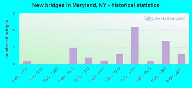
- New bridges - historical statistics
- 11900-1909
- 51930-1939
- 21940-1949
- 11950-1959
- 31960-1969
- 111970-1979
- 11980-1989
- 71990-1999
- 32000-2009

- Reconstructed bridges - Historical Statistics
- 11960-1969
- 01970-1979
- 21980-1989
- 31990-1999
- 22000-2009


- Bridge Condition - Deck
- 3.6%Excellent
- 17.9%Very good
- 39.3%Good
- 28.6%Satisfactory
- 3.6%Fair
- 3.6%Poor
- 3.6%Serious

- Bridge Condition - Superstructure
- 3.4%Excellent
- 13.8%Very good
- 44.8%Good
- 17.2%Satisfactory
- 13.8%Fair
- 6.9%Poor

- Bridge Condition - Substructure
- 13.8%Very good
- 34.5%Good
- 27.6%Satisfactory
- 17.2%Fair
- 6.9%Poor

- Bridge Condition - Channel
- 3.8%Excellent
- 7.7%Very good
- 30.8%Good
- 30.8%Satisfactory
- 23.1%Fair
- 3.8%Poor

- Bridge Condition - Culverts
- 50.0%Good
- 50.0%Satisfactory
Find on map >> Show street view
Structure Number: 100399, Location: .5 MI W OF SCHENEVUS (Lat: 42.545028, Lng: -74.841972), Route carried "on" structure: State highway 7, Year Built: 1994, Status: Open, Structure Length: 3.23m (10.60ft), Average Daily Traffic: 1,535 (year 2017), Truck Traffic: 8%, Average Future Daily Traffic: 1,601 (year 2040), Design Load: HS 25 or greater, Features Intersected: ELK CREEK
Minimum Vertical Clearance: 30+ m (98+ ft), Kilometerpoint: 60.627, Lanes on structure: 2, Base Highway Network: Yes, Owner: State Highway Agency, Approaching Roadway Width: 9.8m (32.2ft), Skew: 4 degrees, Material/Design: Prestressed concrete, Design/Construction: Box Beam or Girders - Multiple, Number Of Spans In Main Unit: 1, Length of Maximum Span: 30.4m (99.7ft), Curb-To-Curb Width: 9.8m (32.2ft), Out-to-Out Width: 10.5m (34.4ft)
Condition: Deck: Satisfactory, Superstructure: Good, Substructure: Good, Channel: Good, Inventory Rating: 60.8 metric tons, Method Used To Determine Inventory Rating: Load Factor (LF), Structural Evaluation: Better than present minimum criteria, Deck Geometry: Somewhat better than minimum adequacy, Waterway Adequacy: Somewhat better than minimum adequacy, Approach Roadway Alignment: Equal to present desirable criteria, Length Of Structure Improvement: 3.23m (10.60ft), Designated Inspection Frequency: Every 24 months, Inspection Date: July 2020, Bridge Improvement Cost: $1,049,000, Roadway Improvement Cost: $614,000, Total Project Cost: $1,663,000 ( Estimate for 2021), Wearing Surface/Protective System: Wearing Surface: Monolithic Concrete
Find on map >> Show street view
Structure Number: 1004, Location: 2.0 MI NE SCHENEVUS (Lat: 42.565000, Lng: -74.783297), Route carried "on" structure: State highway 7, Year Built: 1940, Year Reconstructed: 2003, Status: Open, Structure Length: 0.98m (3.22ft), Average Daily Traffic: 1,328 (year 2020), Truck Traffic: 8%, Average Future Daily Traffic: 1,385 (year 2040), Design Load: H 20, Features Intersected: Palmer Creek, Private Ro
Minimum Vertical Clearance: 30+ m (98+ ft), Kilometerpoint: 66.017, Lanes on structure: 2, Lanes under structure: 1, Base Highway Network: Yes, Owner: State Highway Agency, Approaching Roadway Width: 8.5m (27.9ft), Material/Design: Steel, Design/Construction: Stringer/Multi-beam, Number Of Spans In Main Unit: 1, Length of Maximum Span: 9.1m (29.9ft), Curb-To-Curb Width: 9.3m (30.5ft), Out-to-Out Width: 10.3m (33.8ft)
Condition: Deck: Good, Superstructure: Good, Substructure: Satisfactory, Channel: Satisfactory, Operating Rating: 96.2 metric tons, Method Used To Determine Operating Rating: Load Factor (LF), Inventory Rating: 57.2 metric tons, Method Used To Determine Inventory Rating: Load Factor (LF), Structural Evaluation: Equal to present minimum criteria, Deck Geometry: Somewhat better than minimum adequacy, Underclear: High priority of corrective action, Waterway Adequacy: Somewhat better than minimum adequacy, Approach Roadway Alignment: Equal to present desirable criteria, Length Of Structure Improvement: 0.97m (3.18ft), Designated Inspection Frequency: Every 24 months, Inspection Date: August 2021, Bridge Improvement Cost: $484,000, Roadway Improvement Cost: $284,000, Total Project Cost: $768,000 ( Estimate for 2021), Deck Structure Type: Concrete Cast-file-Place, Wearing Surface/Protective System: Wearing Surface: Integral Concrete
Find on map >> Show street view
Structure Number: 1069601, Location: 2.8 MI W OF SCHENEVUS (Lat: 42.535978, Lng: -74.847442), Route carried "on" structure: Interstate 88, Year Built: 1979, Status: Open, Structure Length: 3.60m (11.81ft), Average Daily Traffic: 4,795 (year 2009), Truck Traffic: 21%, Design Load: HS 20+Mod, Features Intersected: COUNTY ROAD 56
Minimum Vertical Clearance: 30+ m (98+ ft), Kilometerpoint: 36.412, Lanes on structure: 2, Lanes under structure: 2, Base Highway Network: Yes, Owner: State Highway Agency, Approaching Roadway Width: 12.8m (42.0ft), Skew: 3 degrees, Material/Design: Steel, Design/Construction: Stringer/Multi-beam, Number Of Spans In Main Unit: 1, Length of Maximum Span: 34.4m (112.9ft), Curb-To-Curb Width: 12.5m (41.0ft), Out-to-Out Width: 13.4m (44.0ft)
Condition: Deck: Good, Superstructure: Good, Substructure: Satisfactory, Operating Rating: 67.1 metric tons, Method Used To Determine Operating Rating: Load and Resistance Factor Rating (LRFR) rating reported by rating factor(RF) method using HL-93 loadings, Inventory Rating: 51.5 metric tons, Method Used To Determine Inventory Rating: Load and Resistance Factor Rating (LRFR) rating reported by rating factor(RF) method using HL-93 loadings, Structural Evaluation: Equal to present minimum criteria, Deck Geometry: Better than present minimum criteria, Underclear: Meets minimum limits, Approach Roadway Alignment: Equal to present desirable criteria, Length Of Structure Improvement: 3.59m (11.78ft), Designated Inspection Frequency: Every 24 months, Inspection Date: May 2021, Bridge Improvement Cost: $1,349,000, Roadway Improvement Cost: $790,000, Total Project Cost: $2,139,000 ( Estimate for 2021), Deck Structure Type: Concrete Cast-file-Place, Wearing Surface/Protective System: Wearing Surface: Epoxy Overlay, Deck Protection: Epoxy Coated Reinforcing
Find on map >> Show street view
Structure Number: 1069602, Location: 2.8 MI W OF SCHENEVUS (Lat: 42.535706, Lng: -74.847022), Route carried "on" structure: Interstate 88, Year Built: 1979, Status: Open, Structure Length: 3.60m (11.81ft), Average Daily Traffic: 3,657 (year 2020), Truck Traffic: 34%, Average Future Daily Traffic: 4,355 (year 2040), Design Load: HS 20+Mod, Features Intersected: COUNTY ROAD 56
Minimum Vertical Clearance: 30+ m (98+ ft), Kilometerpoint: 36.412, Lanes on structure: 2, Lanes under structure: 2, Base Highway Network: Yes, Owner: State Highway Agency, Approaching Roadway Width: 12.8m (42.0ft), Skew: 3 degrees, Material/Design: Steel, Design/Construction: Stringer/Multi-beam, Number Of Spans In Main Unit: 1, Length of Maximum Span: 34.4m (112.9ft), Curb-To-Curb Width: 12.5m (41.0ft), Out-to-Out Width: 13.4m (44.0ft)
Condition: Deck: Good, Superstructure: Good, Substructure: Good, Operating Rating: 69.7 metric tons, Method Used To Determine Operating Rating: Load and Resistance Factor Rating (LRFR) rating reported by rating factor(RF) method using HL-93 loadings, Inventory Rating: 53.8 metric tons, Method Used To Determine Inventory Rating: Load and Resistance Factor Rating (LRFR) rating reported by rating factor(RF) method using HL-93 loadings, Structural Evaluation: Better than present minimum criteria, Deck Geometry: Better than present minimum criteria, Underclear: Meets minimum limits, Approach Roadway Alignment: Equal to present desirable criteria, Length Of Structure Improvement: 3.59m (11.78ft), Designated Inspection Frequency: Every 24 months, Inspection Date: May 2021, Bridge Improvement Cost: $1,349,000, Roadway Improvement Cost: $790,000, Total Project Cost: $2,139,000 ( Estimate for 2021), Deck Structure Type: Concrete Cast-file-Place, Wearing Surface/Protective System: Wearing Surface: Epoxy Overlay, Deck Protection: Epoxy Coated Reinforcing
Find on map >> Show street view
Structure Number: 106961, Location: SCHENEVUS CONN OVER I-88 (Lat: 42.546458, Lng: -74.811367), Route carried "on" structure: Ramp State highway 991W, Year Built: 1979, Status: Open, Structure Length: 9.36m (30.71ft), Average Daily Traffic: 1,367 (year 2020), Truck Traffic: 7%, Average Future Daily Traffic: 1,426 (year 2040), Design Load: HS 20, Features Intersected: 88I 88I94063134WB, RTE I
Minimum Vertical Clearance: 30+ m (98+ ft), Kilometerpoint: 0.708, Lanes on structure: 2, Lanes under structure: 4, Base Highway Network: Yes, Owner: State Highway Agency, Approaching Roadway Width: 14.6m (47.9ft), Skew: 3 degrees, Material/Design: Steel continuous, Design/Construction: Stringer/Multi-beam, Number Of Spans In Main Unit: 2, Length of Maximum Span: 46.0m (150.9ft), Curb-To-Curb Width: 14.3m (46.9ft), Out-to-Out Width: 15.2m (49.9ft)
Condition: Deck: Satisfactory, Superstructure: Good, Substructure: Good, Inventory Rating: 32.7 metric tons, Method Used To Determine Inventory Rating: Field evaluation and documented engineering judgment, Structural Evaluation: Better than present minimum criteria, Deck Geometry: Superior to present desirable criteria, Underclear: Superior to present desirable criteria, Approach Roadway Alignment: Equal to present desirable criteria, Length Of Structure Improvement: 9.35m (30.68ft), Designated Inspection Frequency: Every 24 months, Inspection Date: June 2021, Bridge Improvement Cost: $3,597,000, Roadway Improvement Cost: $2,107,000, Total Project Cost: $5,704,000 ( Estimate for 2021), Deck Structure Type: Concrete Cast-file-Place, Wearing Surface/Protective System: Wearing Surface: Integral Concrete, Deck Protection: Epoxy Coated Reinforcing
Find on map >> Show street view
Structure Number: 106962, Location: SCHENEVUS CONN OVER I-88 (Lat: 42.548372, Lng: -74.812439), Route carried "on" structure: Ramp Other road 991W, Year Built: 1979, Status: Open, Structure Length: 8.66m (28.41ft), Average Daily Traffic: 1,367 (year 2020), Truck Traffic: 7%, Average Future Daily Traffic: 1,426 (year 2040), Design Load: HS 20, Features Intersected: SCHENEVUS CREEK
Minimum Vertical Clearance: 30+ m (98+ ft), Kilometerpoint: 0.965, Lanes on structure: 2, Base Highway Network: Yes, Owner: State Highway Agency, Approaching Roadway Width: 14.6m (47.9ft), Skew: 2 degrees, Material/Design: Steel continuous, Design/Construction: Stringer/Multi-beam, Number Of Spans In Main Unit: 3, Length of Maximum Span: 39.6m (129.9ft), Curb-To-Curb Width: 14.6m (47.9ft), Out-to-Out Width: 15.2m (49.9ft)
Condition: Deck: Satisfactory, Superstructure: Good, Substructure: Good, Channel: Very good, Operating Rating: 97.1 metric tons, Method Used To Determine Operating Rating: Load Factor (LF), Inventory Rating: 58.1 metric tons, Method Used To Determine Inventory Rating: Load Factor (LF), Structural Evaluation: Better than present minimum criteria, Deck Geometry: Superior to present desirable criteria, Waterway Adequacy: Equal to present minimum criteria, Approach Roadway Alignment: Equal to present desirable criteria, Length Of Structure Improvement: 8.65m (28.38ft), Designated Inspection Frequency: Every 24 months, Inspection Date: June 2020, Bridge Improvement Cost: $2,954,000, Roadway Improvement Cost: $1,730,000, Total Project Cost: $4,684,000 ( Estimate for 2021), Deck Structure Type: Concrete Cast-file-Place, Wearing Surface/Protective System: Wearing Surface: Integral Concrete, Deck Protection: Epoxy Coated Reinforcing
Find on map >> Show street view
Structure Number: 106963, Location: SCHENEVUS CONN OVER D&HRR (Lat: 42.549536, Lng: -74.813244), Route carried "on" structure: Ramp Other road 991W, Year Built: 1979, Status: Open, Structure Length: 5.91m (19.39ft), Average Daily Traffic: 1,367 (year 2020), Truck Traffic: 7%, Average Future Daily Traffic: 1,426 (year 2040), Design Load: HS 20, Features Intersected: MP 538 DELAWARE & HUDS
Minimum Vertical Clearance: 30+ m (98+ ft), Kilometerpoint: 1.126, Lanes on structure: 2, Base Highway Network: Yes, Owner: State Highway Agency, Approaching Roadway Width: 14.6m (47.9ft), Skew: 1 degrees, Material/Design: Steel continuous, Design/Construction: Stringer/Multi-beam, Number Of Spans In Main Unit: 3, Length of Maximum Span: 27.4m (89.9ft), Curb-To-Curb Width: 14.3m (46.9ft), Out-to-Out Width: 15.2m (49.9ft)
Condition: Deck: Good, Superstructure: Satisfactory, Substructure: Good, Operating Rating: 44.1 metric tons, Method Used To Determine Operating Rating: Load and Resistance Factor Rating (LRFR) rating reported by rating factor(RF) method using HL-93 loadings, Inventory Rating: 33.0 metric tons, Method Used To Determine Inventory Rating: Load and Resistance Factor Rating (LRFR) rating reported by rating factor(RF) method using HL-93 loadings, Structural Evaluation: Equal to present minimum criteria, Deck Geometry: Superior to present desirable criteria, Underclear: Superior to present desirable criteria, Approach Roadway Alignment: Equal to present desirable criteria, Length Of Structure Improvement: 5.91m (19.39ft), Designated Inspection Frequency: Every 24 months, Inspection Date: July 2021, Bridge Improvement Cost: $2,087,000, Roadway Improvement Cost: $1,222,000, Total Project Cost: $3,309,000 ( Estimate for 2021), Deck Structure Type: Concrete Cast-file-Place, Wearing Surface/Protective System: Wearing Surface: Integral Concrete, Deck Protection: Epoxy Coated Reinforcing
Find on map >> Show street view
Structure Number: 222761, Location: 2 MI SOUTHEAST OF MARYLAN (Lat: 42.518753, Lng: -74.908575), Route carried "on" structure: Other road , Year Built: 2008, Status: Open, Structure Length: 2.65m (8.69ft), Average Daily Traffic: 18 (year 2019), Truck Traffic: 5%, Average Future Daily Traffic: 25 (year 2039), Design Load: HS 25 or greater, Features Intersected: SCHENEVUS CREEK, Facility Carried by Structure: LEONARD ROAD
Minimum Vertical Clearance: 30+ m (98+ ft), Kilometerpoint: 0.772, Lanes on structure: 1, Owner: Town or Township Highway Agency, Approaching Roadway Width: 4.3m (14.1ft), Material/Design: Prestressed concrete, Design/Construction: Box Beam or Girders - Multiple, Number Of Spans In Main Unit: 1, Length of Maximum Span: 25.3m (83.0ft), Curb-To-Curb Width: 4.2m (13.8ft), Out-to-Out Width: 5.0m (16.4ft)
Condition: Deck: Very good, Superstructure: Good, Substructure: Very good, Channel: Very good, Inventory Rating: 83.5 metric tons, Method Used To Determine Inventory Rating: Load Factor (LF), Structural Evaluation: Better than present minimum criteria, Deck Geometry: Somewhat better than minimum adequacy, Waterway Adequacy: Somewhat better than minimum adequacy, Approach Roadway Alignment: Meets minimum limits, Length Of Structure Improvement: 2.65m (8.69ft), Designated Inspection Frequency: Every 24 months, Inspection Date: September 2020, Bridge Improvement Cost: $300,000, Roadway Improvement Cost: $176,000, Total Project Cost: $476,000 ( Estimate for 2021), Wearing Surface/Protective System: Wearing Surface: Bituminous
Find on map >> Show street view
Structure Number: 222762, Location: HAMLET OF MARYLAND (Lat: 42.535461, Lng: -74.884664), Route carried "on" structure: Other road , Year Built: 1930, Year Reconstructed: 1969, Status: Posted for load, Structure Length: 2.44m (8.01ft), Average Daily Traffic: 71 (year 2017), Truck Traffic: 5%, Average Future Daily Traffic: 99 (year 2037), Features Intersected: SCHENEVUS CREEK, Facility Carried by Structure: LOFT ROAD
Minimum Vertical Clearance: 30+ m (98+ ft), Kilometerpoint: 0.113, Lanes on structure: 1, Owner: Town or Township Highway Agency, Approaching Roadway Width: 4.0m (13.1ft), Material/Design: Steel, Design/Construction: Stringer/Multi-beam, Number Of Spans In Main Unit: 1, Length of Maximum Span: 22.8m (74.8ft), Curb-To-Curb Width: 4.2m (13.8ft), Out-to-Out Width: 4.3m (14.1ft)
Condition: Deck: Poor, Superstructure: Poor, Substructure: Fair, Channel: Fair, Operating Rating: 23.6 metric tons, Method Used To Determine Operating Rating: Load Factor (LF), Inventory Rating: 14.5 metric tons, Method Used To Determine Inventory Rating: Load Factor (LF), Structural Evaluation: Meets minimum limits, Deck Geometry: Somewhat better than minimum adequacy, Waterway Adequacy: Meets minimum limits, Approach Roadway Alignment: Meets minimum limits, Bridge Posting: Required (Relationship of Operating Rating to Maximum Legal Load: > 39.9% below), Length Of Structure Improvement: 2.43m (7.97ft), Designated Inspection Frequency: Every 12 months, Underwater Inspection Frequency: Every 60 months, Inspection Date: August 2021, Underwater Inspection Date: July 2019, Bridge Improvement Cost: $309,000, Roadway Improvement Cost: $181,000, Total Project Cost: $489,000 ( Estimate for 2021), Deck Structure Type: Wood or Timber, Wearing Surface/Protective System: Wearing Surface: Bituminous
Find on map >> Show street view
Structure Number: 222765, Location: VILLAGE OF SCHENEVUS (Lat: 42.546417, Lng: -74.831347), Route carried "on" structure: Other road , Year Built: 1902, Status: Posted for load, Structure Length: 1.83m (6.00ft), Average Daily Traffic: 59 (year 2017), Truck Traffic: 5%, Average Future Daily Traffic: 83 (year 2037), Features Intersected: SCHENEVUS CREEK, Facility Carried by Structure: TANNERY STREET
Minimum Vertical Clearance: 30+ m (98+ ft), Kilometerpoint: 0.676, Lanes on structure: 1, Owner: Town or Township Highway Agency, Approaching Roadway Width: 3.7m (12.1ft), Material/Design: Steel, Design/Construction: Stringer/Multi-beam, Number Of Spans In Main Unit: 1, Length of Maximum Span: 15.2m (49.9ft), Curb-To-Curb Width: 3.9m (12.8ft), Out-to-Out Width: 4.3m (14.1ft)
Condition: Deck: Serious, Superstructure: Fair, Substructure: Fair, Channel: Satisfactory, Operating Rating: 37.2 metric tons, Method Used To Determine Operating Rating: Load Factor (LF), Inventory Rating: 21.8 metric tons, Method Used To Determine Inventory Rating: Load Factor (LF), Structural Evaluation: Somewhat better than minimum adequacy, Deck Geometry: Meets minimum limits, Waterway Adequacy: Somewhat better than minimum adequacy, Approach Roadway Alignment: Meets minimum limits, Bridge Posting: Required (Relationship of Operating Rating to Maximum Legal Load: > 39.9% below), Length Of Structure Improvement: 1.82m (5.97ft), Designated Inspection Frequency: Every 12 months, Inspection Date: September 2021, Bridge Improvement Cost: $247,000, Roadway Improvement Cost: $145,000, Total Project Cost: $392,000 ( Estimate for 2021), Deck Structure Type: Corrugated Steel, Wearing Surface/Protective System: Wearing Surface: Bituminous
Find on map >> Show street view
Structure Number: 3300549, Location: AT STONY BROOK (Lat: 40.911011, Lng: -73.118019), Route carried "on" structure: County highway , Year Built: 1975, Status: Open, Structure Length: 1.37m (4.49ft), Average Daily Traffic: 15,525 (year 2020), Truck Traffic: 4%, Average Future Daily Traffic: 17,912 (year 2040), Features Intersected: HOSPITAL UNDRPASS, HOSPI, Facility Carried by Structure: NICOLLS RD
Minimum Vertical Clearance: 30+ m (98+ ft), Kilometerpoint: 21.174, Lanes on structure: 4, Lanes under structure: 2, Owner: State Agenciy, Approaching Roadway Width: 40.2m (131.9ft), Skew: 31 degrees, Material/Design: Concrete, Design/Construction: Slab, Number Of Spans In Main Unit: 2, Length of Maximum Span: 7.9m (25.9ft), Curb-To-Curb Width: 40.2m (131.9ft), Out-to-Out Width: 47.9m (157.2ft)
Condition: Superstructure: Satisfactory, Substructure: Good, Operating Rating: 46.3 metric tons, Method Used To Determine Operating Rating: Load Factor (LF), Inventory Rating: 28.1 metric tons, Method Used To Determine Inventory Rating: Load Factor (LF), Structural Evaluation: Equal to present minimum criteria, Deck Geometry: Superior to present desirable criteria, Underclear: High priority of corrective action, Approach Roadway Alignment: Equal to present desirable criteria, Length Of Structure Improvement: 1.37m (4.49ft), Designated Inspection Frequency: Every 24 months, Inspection Date: March 2020, Bridge Improvement Cost: $4,455,000, Roadway Improvement Cost: $2,609,000, Total Project Cost: $7,064,000 ( Estimate for 2021), Wearing Surface/Protective System: Wearing Surface: Bituminous
Find on map >> Show street view
Structure Number: 333002, Location: 4.4 MI S OF BELFAST (Lat: 42.278497, Lng: -78.129942), Route carried "on" structure: County highway , Year Built: 1977, Year Reconstructed: 2013, Status: Open, Structure Length: 1.89m (6.20ft), Average Daily Traffic: 215 (year 2018), Truck Traffic: 4%, Average Future Daily Traffic: 301 (year 2038), Design Load: HS 25 or greater, Features Intersected: WHITE CREEK, Facility Carried by Structure: COUNTY ROAD 41
Minimum Vertical Clearance: 30+ m (98+ ft), Kilometerpoint: 8.077, Lanes on structure: 2, Owner: County Highway Agency, Approaching Roadway Width: 7.0m (23.0ft), Skew: 1 degrees, Material/Design: Prestressed concrete, Design/Construction: Box Beam or Girders - Multiple, Number Of Spans In Main Unit: 1, Length of Maximum Span: 18.6m (61.0ft), Curb-To-Curb Width: 9.0m (29.5ft), Out-to-Out Width: 9.2m (30.2ft)
Condition: Deck: Excellent, Superstructure: Excellent, Substructure: Satisfactory, Channel: Good, Operating Rating: 95.3 metric tons, Method Used To Determine Operating Rating: Load Factor (LF), Inventory Rating: 57.2 metric tons, Method Used To Determine Inventory Rating: Load Factor (LF), Structural Evaluation: Equal to present minimum criteria, Deck Geometry: Equal to present minimum criteria, Waterway Adequacy: Superior to present desirable criteria, Approach Roadway Alignment: Meets minimum limits, Length Of Structure Improvement: 1.88m (6.17ft), Designated Inspection Frequency: Every 24 months, Inspection Date: June 2021, Bridge Improvement Cost: $601,000, Roadway Improvement Cost: $352,000, Total Project Cost: $953,000 ( Estimate for 2021), Wearing Surface/Protective System: Wearing Surface: Bituminous, Membrane: Other
Find on map >> Show street view
Structure Number: 333011, Location: 2.7 MI SW OF CANASERAGA (Lat: 42.432717, Lng: -77.815175), Route carried "on" structure: County highway , Year Built: 1991, Status: Open, Structure Length: 2.04m (6.69ft), Average Daily Traffic: 189 (year 2019), Truck Traffic: 8%, Average Future Daily Traffic: 265 (year 2039), Design Load: HS 20, Features Intersected: SLADER CREEK, Facility Carried by Structure: COUNTY ROAD 13C
Minimum Vertical Clearance: 30+ m (98+ ft), Kilometerpoint: 1.094, Lanes on structure: 2, Owner: County Highway Agency, Approaching Roadway Width: 7.3m (24.0ft), Skew: 4 degrees, Material/Design: Prestressed concrete, Design/Construction: Box Beam or Girders - Multiple, Number Of Spans In Main Unit: 1, Length of Maximum Span: 19.5m (64.0ft), Curb-To-Curb Width: 9.2m (30.2ft), Out-to-Out Width: 9.8m (32.2ft)
Condition: Deck: Good, Superstructure: Very good, Substructure: Very good, Channel: Satisfactory, Operating Rating: 59.9 metric tons, Method Used To Determine Operating Rating: Load Factor (LF), Inventory Rating: 32.7 metric tons, Method Used To Determine Inventory Rating: Load Factor (LF), Structural Evaluation: Equal to present desirable criteria, Deck Geometry: Equal to present minimum criteria, Waterway Adequacy: Equal to present desirable criteria, Approach Roadway Alignment: Equal to present desirable criteria, Length Of Structure Improvement: 2.04m (6.69ft), Designated Inspection Frequency: Every 24 months, Inspection Date: August 2020, Bridge Improvement Cost: $635,000, Roadway Improvement Cost: $372,000, Total Project Cost: $1,007,000 ( Estimate for 2021), Wearing Surface/Protective System: Wearing Surface: Bituminous, Membrane: Other
Find on map >> Show street view
Structure Number: 333022, Location: 3.0 MI NW OF CUBA (Lat: 42.255925, Lng: -78.299656), Route carried "on" structure: County highway , Year Built: 1997, Status: Open, Structure Length: 1.04m (3.41ft), Average Daily Traffic: 947 (year 2016), Truck Traffic: 3%, Average Future Daily Traffic: 1,326 (year 2036), Design Load: HS 25 or greater, Features Intersected: TRIB CUBA LAKE, Facility Carried by Structure: COUNTY ROAD 7D
Minimum Vertical Clearance: 30+ m (98+ ft), Kilometerpoint: 1.883, Lanes on structure: 2, Owner: County Highway Agency, Approaching Roadway Width: 6.7m (22.0ft), Skew: 2 degrees, Material/Design: Wood or Timber, Design/Construction: Slab, Number Of Spans In Main Unit: 1, Length of Maximum Span: 10.0m (32.8ft), Curb-To-Curb Width: 9.1m (29.9ft), Out-to-Out Width: 9.8m (32.2ft)
Condition: Deck: Very good, Superstructure: Very good, Substructure: Good, Channel: Good, Operating Rating: 72.6 metric tons, Method Used To Determine Operating Rating: Load Factor (LF), Inventory Rating: 49.9 metric tons, Method Used To Determine Inventory Rating: Load Factor (LF), Structural Evaluation: Better than present minimum criteria, Deck Geometry: Equal to present minimum criteria, Waterway Adequacy: Better than present minimum criteria, Approach Roadway Alignment: Better than present minimum criteria, Length Of Structure Improvement: 1.03m (3.38ft), Designated Inspection Frequency: Every 24 months, Inspection Date: August 2021, Bridge Improvement Cost: $848,000, Roadway Improvement Cost: $496,000, Total Project Cost: $1,344,000 ( Estimate for 2021), Wearing Surface/Protective System: Wearing Surface: Bituminous, Membrane: Preformed Fabric
Find on map >> Show street view
Structure Number: 333034, Location: 1.0 MI NW OF ROSSBURG (Lat: 42.504300, Lng: -78.082147), Route carried "on" structure: County highway , Year Built: 1978, Status: Open, Structure Length: 5.12m (16.80ft), Average Daily Traffic: 178 (year 2017), Truck Traffic: 7%, Average Future Daily Traffic: 249 (year 2037), Features Intersected: WISCOY CREEK, Facility Carried by Structure: COUNTY ROAD 27
Minimum Vertical Clearance: 30+ m (98+ ft), Kilometerpoint: 1.319, Lanes on structure: 2, Owner: County Highway Agency, Approaching Roadway Width: 5.8m (19.0ft), Material/Design: Prestressed concrete, Design/Construction: Box Beam or Girders - Multiple, Number Of Spans In Main Unit: 2, Length of Maximum Span: 25.2m (82.7ft), Curb-To-Curb Width: 8.1m (26.6ft), Out-to-Out Width: 8.7m (28.5ft)
Condition: Deck: Good, Superstructure: Fair, Substructure: Satisfactory, Channel: Satisfactory, Operating Rating: 42.1 metric tons, Method Used To Determine Operating Rating: Load and Resistance Factor Rating (LRFR) rating reported by rating factor(RF) method using HL-93 loadings, Inventory Rating: 17.2 metric tons, Method Used To Determine Inventory Rating: Load and Resistance Factor Rating (LRFR) rating reported by rating factor(RF) method using HL-93 loadings, Structural Evaluation: Somewhat better than minimum adequacy, Deck Geometry: Somewhat better than minimum adequacy, Waterway Adequacy: Better than present minimum criteria, Approach Roadway Alignment: Meets minimum limits, Length Of Structure Improvement: 5.12m (16.80ft), Designated Inspection Frequency: Every 24 months, Inspection Date: November 2020, Bridge Improvement Cost: $1,192,000, Roadway Improvement Cost: $698,000, Total Project Cost: $1,890,000 ( Estimate for 2021), Deck Structure Type: Concrete Cast-file-Place, Wearing Surface/Protective System: Wearing Surface: Bituminous
Find on map >> Show street view
Structure Number: 333066, Location: IN WEST ALMOND (Lat: 42.300350, Lng: -77.882650), Route carried "on" structure: County highway , Year Built: 1964, Status: Open, Structure Length: 0.88m (2.89ft), Average Daily Traffic: 204 (year 2019), Truck Traffic: 7%, Average Future Daily Traffic: 286 (year 2039), Design Load: HS 20, Features Intersected: ANGELICA CREEK, Facility Carried by Structure: COUNTY ROAD 2
Minimum Vertical Clearance: 30+ m (98+ ft), Kilometerpoint: 9.413, Lanes on structure: 2, Owner: County Highway Agency, Approaching Roadway Width: 6.1m (20.0ft), Skew: 3 degrees, Material/Design: Steel, Design/Construction: Stringer/Multi-beam, Number Of Spans In Main Unit: 1, Length of Maximum Span: 8.2m (26.9ft), Curb-To-Curb Width: 8.6m (28.2ft), Out-to-Out Width: 8.8m (28.9ft)
Condition: Deck: Satisfactory, Superstructure: Good, Substructure: Satisfactory, Channel: Good, Operating Rating: 57.2 metric tons, Method Used To Determine Operating Rating: Load Factor (LF), Inventory Rating: 40.8 metric tons, Method Used To Determine Inventory Rating: Load Factor (LF), Structural Evaluation: Equal to present minimum criteria, Deck Geometry: Equal to present minimum criteria, Waterway Adequacy: Somewhat better than minimum adequacy, Approach Roadway Alignment: Equal to present desirable criteria, Length Of Structure Improvement: 0.88m (2.89ft), Designated Inspection Frequency: Every 24 months, Inspection Date: March 2020, Bridge Improvement Cost: $355,000, Roadway Improvement Cost: $208,000, Total Project Cost: $563,000 ( Estimate for 2021), Deck Structure Type: Wood or Timber, Wearing Surface/Protective System: Wearing Surface: Bituminous, Membrane: Other
Find on map >> Show street view
Structure Number: 333071, Location: 0.9 MI E OF FILLMORE (Lat: 42.464569, Lng: -78.094969), Route carried "on" structure: County highway , Year Built: 1983, Status: Open, Structure Length: 3.81m (12.50ft), Average Daily Traffic: 186 (year 2018), Truck Traffic: 7%, Average Future Daily Traffic: 260 (year 2038), Design Load: HS 20, Features Intersected: RUSH CREEK, Facility Carried by Structure: CR 27B
Minimum Vertical Clearance: 30+ m (98+ ft), Kilometerpoint: 0.499, Lanes on structure: 2, Owner: County Highway Agency, Approaching Roadway Width: 7.6m (24.9ft), Material/Design: Prestressed concrete, Design/Construction: Box Beam or Girders - Multiple, Number Of Spans In Main Unit: 2, Length of Maximum Span: 18.2m (59.7ft), Curb-To-Curb Width: 7.9m (25.9ft), Out-to-Out Width: 8.8m (28.9ft)
Condition: Deck: Good, Superstructure: Good, Substructure: Good, Channel: Fair, Operating Rating: 43.7 metric tons, Method Used To Determine Operating Rating: Load and Resistance Factor Rating (LRFR) rating reported by rating factor(RF) method using HL-93 loadings, Inventory Rating: 28.2 metric tons, Method Used To Determine Inventory Rating: Load and Resistance Factor Rating (LRFR) rating reported by rating factor(RF) method using HL-93 loadings, Structural Evaluation: Better than present minimum criteria, Deck Geometry: Somewhat better than minimum adequacy, Waterway Adequacy: Better than present minimum criteria, Approach Roadway Alignment: Equal to present desirable criteria, Length Of Structure Improvement: 3.81m (12.50ft), Designated Inspection Frequency: Every 24 months, Inspection Date: August 2020, Bridge Improvement Cost: $794,000, Roadway Improvement Cost: $465,000, Total Project Cost: $1,259,000 ( Estimate for 2021), Deck Structure Type: Concrete Cast-file-Place, Wearing Surface/Protective System: Wearing Surface: Bituminous, Deck Protection: Epoxy Coated Reinforcing
Find on map >> Show street view
Structure Number: 333083, Location: 6.8 MILES EAST OF ELMIRA (Lat: 42.095903, Lng: -76.692361), Route carried "on" structure: County highway , Year Built: 1940, Year Reconstructed: 1991, Status: Open, Structure Length: 0.98m (3.22ft), Average Daily Traffic: 1,235 (year 2020), Truck Traffic: 6%, Average Future Daily Traffic: 1,729 (year 2040), Features Intersected: TRB BALDWIN CREEK, Facility Carried by Structure: CR01 BREESPORT RO
Minimum Vertical Clearance: 30+ m (98+ ft), Kilometerpoint: 9.429, Lanes on structure: 2, Owner: County Highway Agency, Approaching Roadway Width: 6.7m (22.0ft), Skew: 1 degrees, Material/Design: Wood or Timber, Design/Construction: Slab, Number Of Spans In Main Unit: 1, Length of Maximum Span: 9.1m (29.9ft), Curb-To-Curb Width: 9.6m (31.5ft), Out-to-Out Width: 10.1m (33.1ft)
Condition: Deck: Good, Superstructure: Good, Substructure: Satisfactory, Channel: Good, Operating Rating: 66.5 metric tons, Method Used To Determine Operating Rating: Field evaluation and documented engineering judgment, Inventory Rating: 28.5 metric tons, Method Used To Determine Inventory Rating: Field evaluation and documented engineering judgment, Structural Evaluation: Equal to present minimum criteria, Deck Geometry: Somewhat better than minimum adequacy, Waterway Adequacy: Equal to present desirable criteria, Approach Roadway Alignment: Equal to present minimum criteria, Length Of Structure Improvement: 0.97m (3.18ft), Designated Inspection Frequency: Every 24 months, Inspection Date: April 2020, Bridge Improvement Cost: $374,000, Roadway Improvement Cost: $219,000, Total Project Cost: $593,000 ( Estimate for 2021), Wearing Surface/Protective System: Wearing Surface: Bituminous
Find on map >> Show street view
Structure Number: 333088, Location: 1.1 MI N OF CHEMUNG (Lat: 42.025089, Lng: -76.622542), Route carried "on" structure: County highway , Year Built: 1956, Status: Open, Structure Length: 1.98m (6.50ft), Average Daily Traffic: 1,050 (year 2020), Truck Traffic: 19%, Average Future Daily Traffic: 1,095 (year 2040), Design Load: HS 20, Features Intersected: WYNCOOP CREEK, Facility Carried by Structure: CR03 WYNCOOP CRK
Minimum Vertical Clearance: 30+ m (98+ ft), Kilometerpoint: 1.866, Lanes on structure: 2, Owner: County Highway Agency, Approaching Roadway Width: 5.5m (18.0ft), Skew: 3 degrees, Material/Design: Steel, Design/Construction: Stringer/Multi-beam, Number Of Spans In Main Unit: 1, Length of Maximum Span: 18.5m (60.7ft), Curb or Sidewalk Widths: Left: 0.6m (2.0ft), Right: 0.6m (2.0ft), Curb-To-Curb Width: 7.3m (24.0ft), Out-to-Out Width: 9.4m (30.8ft)
Condition: Deck: Satisfactory, Superstructure: Satisfactory, Substructure: Satisfactory, Channel: Good, Operating Rating: 49.6 metric tons, Method Used To Determine Operating Rating: Load and Resistance Factor Rating (LRFR) rating reported by rating factor(RF) method using HL-93 loadings, Inventory Rating: 38.2 metric tons, Method Used To Determine Inventory Rating: Load and Resistance Factor Rating (LRFR) rating reported by rating factor(RF) method using HL-93 loadings, Structural Evaluation: Equal to present minimum criteria, Deck Geometry: Meets minimum limits, Waterway Adequacy: Equal to present desirable criteria, Approach Roadway Alignment: Somewhat better than minimum adequacy, Length Of Structure Improvement: 1.98m (6.50ft), Designated Inspection Frequency: Every 24 months, Inspection Date: May 2020, Bridge Improvement Cost: $878,000, Roadway Improvement Cost: $514,000, Total Project Cost: $1,392,000 ( Estimate for 2021), Deck Structure Type: Concrete Cast-file-Place, Wearing Surface/Protective System: Wearing Surface: Bituminous
Find on map >> Show street view
Structure Number: 333153, Location: 4.1 MI W OF ELMIRA (Lat: 42.083300, Lng: -76.881567), Route carried "on" structure: Other road , Year Built: 1961, Year Reconstructed: 2000, Status: Open, Structure Length: 1.22m (4.00ft), Average Daily Traffic: 244 (year 2020), Truck Traffic: 5%, Average Future Daily Traffic: 342 (year 2040), Design Load: HS 25 or greater, Features Intersected: HENDY CREEK, Facility Carried by Structure: BENNETT ROAD
Minimum Vertical Clearance: 30+ m (98+ ft), Kilometerpoint: 0.225, Lanes on structure: 2, Owner: County Highway Agency, Approaching Roadway Width: 6.1m (20.0ft), Material/Design: Wood or Timber, Design/Construction: Stringer/Multi-beam, Number Of Spans In Main Unit: 1, Length of Maximum Span: 11.6m (38.1ft), Curb-To-Curb Width: 6.1m (20.0ft), Out-to-Out Width: 6.7m (22.0ft)
Condition: Deck: Very good, Superstructure: Fair, Substructure: Fair, Channel: Satisfactory, Operating Rating: 51.7 metric tons, Method Used To Determine Operating Rating: Allowable Stress (AS), Inventory Rating: 35.4 metric tons, Method Used To Determine Inventory Rating: Allowable Stress (AS), Structural Evaluation: Somewhat better than minimum adequacy, Deck Geometry: Meets minimum limits, Waterway Adequacy: Better than present minimum criteria, Approach Roadway Alignment: Equal to present desirable criteria, Length Of Structure Improvement: 1.21m (3.97ft), Designated Inspection Frequency: Every 24 months, Inspection Date: March 2021, Bridge Improvement Cost: $261,000, Roadway Improvement Cost: $153,000, Total Project Cost: $414,000 ( Estimate for 2021), Deck Structure Type: Wood or Timber, Wearing Surface/Protective System: Wearing Surface: Bituminous
Find on map >> Show street view
Structure Number: 333165, Location: IN VAN ETTEN (Lat: 42.198925, Lng: -76.557872), Route carried "on" structure: County highway , Year Built: 1934, Year Reconstructed: 1991, Status: Open, Structure Length: 0.98m (3.22ft), Average Daily Traffic: 493 (year 2018), Truck Traffic: 2%, Average Future Daily Traffic: 690 (year 2038), Design Load: HS 20, Features Intersected: LANGFORD CREEK, Facility Carried by Structure: CR62 MAIN ST
Minimum Vertical Clearance: 30+ m (98+ ft), Kilometerpoint: 0.917, Lanes on structure: 2, Owner: County Highway Agency, Approaching Roadway Width: 7.6m (24.9ft), Skew: 2 degrees, Material/Design: Wood or Timber, Design/Construction: Slab, Number Of Spans In Main Unit: 1, Length of Maximum Span: 9.1m (29.9ft), Curb or Sidewalk Widths: Left: 1.5m (4.9ft), Right: 0.0m, Curb-To-Curb Width: 7.6m (24.9ft), Out-to-Out Width: 9.6m (31.5ft)
Condition: Deck: Good, Superstructure: Good, Substructure: Satisfactory, Channel: Satisfactory, Operating Rating: 89.8 metric tons, Method Used To Determine Operating Rating: Load Factor (LF), Inventory Rating: 67.1 metric tons, Method Used To Determine Inventory Rating: Load Factor (LF), Structural Evaluation: Equal to present minimum criteria, Deck Geometry: Meets minimum limits, Waterway Adequacy: Equal to present desirable criteria, Approach Roadway Alignment: Equal to present minimum criteria, Length Of Structure Improvement: 0.97m (3.18ft), Designated Inspection Frequency: Every 24 months, Inspection Date: June 2020, Bridge Improvement Cost: $385,000, Roadway Improvement Cost: $225,000, Total Project Cost: $611,000 ( Estimate for 2021), Deck Structure Type: Wood or Timber, Wearing Surface/Protective System: Wearing Surface: Bituminous
Find on map >> Show street view
Structure Number: 333181, Location: 2.0 MI SW OF ERIN (Lat: 42.173533, Lng: -76.707969), Route carried "on" structure: Other road , Year Built: 1934, Year Reconstructed: 2001, Status: Posted for load, Structure Length: 1.19m (3.90ft), Average Daily Traffic: 160 (year 2018), Truck Traffic: 5%, Average Future Daily Traffic: 224 (year 2038), Features Intersected: NEWTOWN CREEK, Facility Carried by Structure: LANGDON HILL ROAD
Minimum Vertical Clearance: 30+ m (98+ ft), Kilometerpoint: 4.682, Lanes on structure: 1, Owner: County Highway Agency, Approaching Roadway Width: 4.6m (15.1ft), Material/Design: Steel, Design/Construction: Stringer/Multi-beam, Number Of Spans In Main Unit: 1, Length of Maximum Span: 11.5m (37.7ft), Curb-To-Curb Width: 4.8m (15.7ft), Out-to-Out Width: 4.9m (16.1ft)
Condition: Deck: Good, Superstructure: Fair, Substructure: Poor, Channel: Poor, Operating Rating: 38.9 metric tons, Method Used To Determine Operating Rating: Load and Resistance Factor Rating (LRFR) rating reported by rating factor(RF) method using HL-93 loadings, Inventory Rating: 30.1 metric tons, Method Used To Determine Inventory Rating: Load and Resistance Factor Rating (LRFR) rating reported by rating factor(RF) method using HL-93 loadings, Structural Evaluation: Meets minimum limits, Deck Geometry: High priority of corrective action, Waterway Adequacy: Superior to present desirable criteria, Approach Roadway Alignment: Meets minimum limits, Bridge Posting: Required (Relationship of Operating Rating to Maximum Legal Load: > 39.9% below), Length Of Structure Improvement: 1.18m (3.87ft), Designated Inspection Frequency: Every 12 months, Inspection Date: September 2021, Bridge Improvement Cost: $307,000, Roadway Improvement Cost: $180,000, Total Project Cost: $487,000 ( Estimate for 2021), Deck Structure Type: Wood or Timber, Wearing Surface/Protective System: Wearing Surface: Other
Find on map >> Show street view
Structure Number: 333194, Location: 1.0 MI SO OF VAN ETTEN (Lat: 42.190922, Lng: -76.565453), Route carried "on" structure: Other road , Year Built: 1990, Status: Open, Structure Length: 2.93m (9.61ft), Average Daily Traffic: 78 (year 2019), Truck Traffic: 5%, Average Future Daily Traffic: 109 (year 2039), Features Intersected: CAYUTA CREEK, Facility Carried by Structure: BECKHORN HOLLOW
Minimum Vertical Clearance: 30+ m (98+ ft), Kilometerpoint: 0.016, Lanes on structure: 2, Owner: County Highway Agency, Approaching Roadway Width: 5.2m (17.1ft), Skew: 4 degrees, Material/Design: Prestressed concrete, Design/Construction: Box Beam or Girders - Multiple, Number Of Spans In Main Unit: 1, Length of Maximum Span: 29.0m (95.1ft), Curb-To-Curb Width: 5.3m (17.4ft), Out-to-Out Width: 5.8m (19.0ft)
Condition: Deck: Good, Superstructure: Very good, Substructure: Good, Channel: Good, Operating Rating: 93.3 metric tons, Method Used To Determine Operating Rating: Field evaluation and documented engineering judgment, Inventory Rating: 32.7 metric tons, Method Used To Determine Inventory Rating: Field evaluation and documented engineering judgment, Structural Evaluation: Better than present minimum criteria, Deck Geometry: High priority of corrective action, Waterway Adequacy: Somewhat better than minimum adequacy, Approach Roadway Alignment: Somewhat better than minimum adequacy, Length Of Structure Improvement: 2.92m (9.58ft), Designated Inspection Frequency: Every 24 months, Inspection Date: May 2020, Bridge Improvement Cost: $555,000, Roadway Improvement Cost: $325,000, Total Project Cost: $879,000 ( Estimate for 2021), Wearing Surface/Protective System: Wearing Surface: Bituminous, Membrane: Other
Find on map >> Show street view
Structure Number: 333198, Location: 5.0 MI SW OF VAN ETTEN (Lat: 42.141814, Lng: -76.606969), Route carried "on" structure: Other road , Year Built: 1993, Status: Open, Structure Length: 0.73m (2.40ft), Average Daily Traffic: 107 (year 2018), Truck Traffic: 2%, Average Future Daily Traffic: 150 (year 2038), Features Intersected: TRIB WYNCOOP CRK, Facility Carried by Structure: RUMSEY HILL ROAD
Minimum Vertical Clearance: 30+ m (98+ ft), Kilometerpoint: 7.965, Lanes on structure: 2, Owner: County Highway Agency, Approaching Roadway Width: 6.1m (20.0ft), Skew: 2 degrees, Material/Design: Aluminum, Iron, Design/Construction: Culvert, Number Of Spans In Main Unit: 1, Length of Maximum Span: 7.0m (23.0ft)
Condition: Channel: Fair, Culverts: Satisfactory, Operating Rating: 59.0 metric tons, Method Used To Determine Operating Rating: Load Factor (LF), Inventory Rating: 35.4 metric tons, Method Used To Determine Inventory Rating: Load Factor (LF), Structural Evaluation: Equal to present minimum criteria, Waterway Adequacy: Equal to present desirable criteria, Approach Roadway Alignment: Equal to present desirable criteria, Length Of Structure Improvement: 0.73m (2.40ft), Designated Inspection Frequency: Every 24 months, Inspection Date: April 2020, Bridge Improvement Cost: $97,000, Roadway Improvement Cost: $57,000, Total Project Cost: $154,000 ( Estimate for 2021), Wearing Surface/Protective System: Wearing Surface: Bituminous
Find on map >> Show street view
Structure Number: 333259, Location: 1.0 MI N OF MONTEREY (Lat: 42.316642, Lng: -77.042203), Route carried "on" structure: County highway , Year Built: 1936, Year Reconstructed: 1997, Status: Open, Structure Length: 1.65m (5.41ft), Average Daily Traffic: 400 (year 2016), Truck Traffic: 7%, Average Future Daily Traffic: 560 (year 2036), Design Load: HS 25 or greater, Features Intersected: TRIB MEADS CREEK, Facility Carried by Structure: COUNTY ROAD 22
Minimum Vertical Clearance: 30+ m (98+ ft), Kilometerpoint: 0.660, Lanes on structure: 2, Owner: County Highway Agency, Approaching Roadway Width: 6.1m (20.0ft), Material/Design: Prestressed concrete, Design/Construction: Box Beam or Girders - Multiple, Number Of Spans In Main Unit: 1, Length of Maximum Span: 15.8m (51.8ft), Curb-To-Curb Width: 7.4m (24.3ft), Out-to-Out Width: 7.7m (25.3ft)
Condition: Deck: Satisfactory, Superstructure: Satisfactory, Substructure: Fair, Channel: Satisfactory, Operating Rating: 72.6 metric tons, Method Used To Determine Operating Rating: Load Factor (LF), Inventory Rating: 40.8 metric tons, Method Used To Determine Inventory Rating: Load Factor (LF), Structural Evaluation: Somewhat better than minimum adequacy, Deck Geometry: Somewhat better than minimum adequacy, Waterway Adequacy: Meets minimum limits, Approach Roadway Alignment: Equal to present desirable criteria, Length Of Structure Improvement: 1.64m (5.38ft), Designated Inspection Frequency: Every 24 months, Inspection Date: March 2021, Bridge Improvement Cost: $476,000, Roadway Improvement Cost: $279,000, Total Project Cost: $755,000 ( Estimate for 2021), Wearing Surface/Protective System: Wearing Surface: Bituminous, Membrane: Other
Find on map >> Show street view
Structure Number: 333264, Location: 1 MILE S OF MONTEREY (Lat: 42.291211, Lng: -77.049261), Route carried "on" structure: County highway , Year Built: 1996, Status: Open, Structure Length: 1.89m (6.20ft), Average Daily Traffic: 128 (year 2016), Truck Traffic: 5%, Average Future Daily Traffic: 179 (year 2036), Design Load: HS 25 or greater, Features Intersected: TRIB MEADS CREEK, Facility Carried by Structure: HORNBY ROAD
Minimum Vertical Clearance: 30+ m (98+ ft), Kilometerpoint: 1.577, Lanes on structure: 2, Owner: County Highway Agency, Approaching Roadway Width: 6.1m (20.0ft), Material/Design: Wood or Timber, Design/Construction: Tee Beam, Number Of Spans In Main Unit: 1, Length of Maximum Span: 18.2m (59.7ft), Curb-To-Curb Width: 7.2m (23.6ft), Out-to-Out Width: 7.8m (25.6ft)
Condition: Deck: Very good, Superstructure: Good, Substructure: Very good, Channel: Satisfactory, Operating Rating: 78.9 metric tons, Method Used To Determine Operating Rating: Load Factor (LF), Inventory Rating: 54.4 metric tons, Method Used To Determine Inventory Rating: Load Factor (LF), Structural Evaluation: Better than present minimum criteria, Deck Geometry: Meets minimum limits, Waterway Adequacy: Equal to present minimum criteria, Approach Roadway Alignment: Equal to present desirable criteria, Length Of Structure Improvement: 1.88m (6.17ft), Designated Inspection Frequency: Every 24 months, Inspection Date: March 2021, Bridge Improvement Cost: $444,000, Roadway Improvement Cost: $260,000, Total Project Cost: $704,000 ( Estimate for 2021), Deck Structure Type: Wood or Timber, Wearing Surface/Protective System: Wearing Surface: Bituminous, Membrane: Other
Find on map >> Show street view
Structure Number: 333292, Location: 1.6 MI SE OF WALLACE (Lat: 42.428406, Lng: -77.430981), Route carried "on" structure: County highway , Year Built: 1964, Status: Open, Structure Length: 1.13m (3.71ft), Average Daily Traffic: 595 (year 2018), Truck Traffic: 4%, Average Future Daily Traffic: 833 (year 2038), Design Load: HS 20, Features Intersected: TENMILE CREEK, Facility Carried by Structure: COUNTY ROAD 105
Minimum Vertical Clearance: 30+ m (98+ ft), Kilometerpoint: 2.880, Lanes on structure: 2, Owner: County Highway Agency, Approaching Roadway Width: 7.0m (23.0ft), Skew: 1 degrees, Material/Design: Concrete continuous, Design/Construction: Culvert, Number Of Spans In Main Unit: 2, Length of Maximum Span: 5.4m (17.7ft), Curb-To-Curb Width: 9.8m (32.2ft), Out-to-Out Width: 10.7m (35.1ft)
Condition: Channel: Fair, Culverts: Good, Operating Rating: 64.4 metric tons, Method Used To Determine Operating Rating: Load Factor (LF), Inventory Rating: 27.2 metric tons, Method Used To Determine Inventory Rating: Load Factor (LF), Structural Evaluation: Equal to present minimum criteria, Deck Geometry: Equal to present minimum criteria, Waterway Adequacy: Better than present minimum criteria, Approach Roadway Alignment: Equal to present desirable criteria, Length Of Structure Improvement: 1.12m (3.67ft), Designated Inspection Frequency: Every 24 months, Inspection Date: June 2021, Bridge Improvement Cost: $496,000, Roadway Improvement Cost: $291,000, Total Project Cost: $787,000 ( Estimate for 2021)
Find on map >> Show street view
Structure Number: 335428, Location: 1 MI N OF SCHENEVUS (Lat: 42.559786, Lng: -74.831211), Route carried "on" structure: County highway , Year Built: 2003, Status: Open, Structure Length: 3.47m (11.38ft), Average Daily Traffic: 510 (year 2017), Truck Traffic: 5%, Average Future Daily Traffic: 714 (year 2037), Design Load: HS 25 or greater, Features Intersected: ELK CREEK, Facility Carried by Structure: COUNTY ROAD 34
Minimum Vertical Clearance: 30+ m (98+ ft), Kilometerpoint: 1.416, Lanes on structure: 2, Owner: County Highway Agency, Approaching Roadway Width: 10.1m (33.1ft), Skew: 5 degrees, Material/Design: Steel, Design/Construction: Stringer/Multi-beam, Number Of Spans In Main Unit: 1, Length of Maximum Span: 32.0m (105.0ft), Curb-To-Curb Width: 10.2m (33.5ft), Out-to-Out Width: 11.2m (36.7ft)
Condition: Deck: Very good, Superstructure: Very good, Substructure: Very good, Channel: Excellent, Operating Rating: 51.7 metric tons, Method Used To Determine Operating Rating: Load Factor (LF), Inventory Rating: 30.8 metric tons, Method Used To Determine Inventory Rating: Load Factor (LF), Structural Evaluation: Better than present minimum criteria, Deck Geometry: Equal to present minimum criteria, Waterway Adequacy: Equal to present desirable criteria, Approach Roadway Alignment: Equal to present desirable criteria, Length Of Structure Improvement: 3.47m (11.38ft), Designated Inspection Frequency: Every 24 months, Inspection Date: April 2021, Bridge Improvement Cost: $2,116,000, Roadway Improvement Cost: $1,239,000, Total Project Cost: $3,355,000 ( Estimate for 2021), Deck Structure Type: Concrete Cast-file-Place, Wearing Surface/Protective System: Wearing Surface: Integral Concrete, Deck Protection: Epoxy Coated Reinforcing
Find on map >> Show street view
Structure Number: 335429, Location: 1.0 MILES NW OF SCHENEVUS (Lat: 42.562156, Lng: -74.835967), Route carried "on" structure: County highway , Year Built: 1939, Status: Open, Structure Length: 0.79m (2.59ft), Average Daily Traffic: 505 (year 2018), Truck Traffic: 5%, Average Future Daily Traffic: 707 (year 2038), Features Intersected: TUTHILL BROOK, Facility Carried by Structure: COUNTY ROAD 34
Minimum Vertical Clearance: 30+ m (98+ ft), Kilometerpoint: 1.963, Lanes on structure: 2, Owner: County Highway Agency, Approaching Roadway Width: 9.1m (29.9ft), Skew: 2 degrees, Material/Design: Concrete, Design/Construction: Slab, Number Of Spans In Main Unit: 1, Length of Maximum Span: 7.6m (24.9ft), Curb-To-Curb Width: 10.3m (33.8ft), Out-to-Out Width: 11.1m (36.4ft)
Condition: Deck: Satisfactory, Superstructure: Satisfactory, Substructure: Fair, Channel: Fair, Operating Rating: 80.7 metric tons, Method Used To Determine Operating Rating: Load Factor (LF), Inventory Rating: 48.1 metric tons, Method Used To Determine Inventory Rating: Load Factor (LF), Structural Evaluation: Somewhat better than minimum adequacy, Deck Geometry: Equal to present minimum criteria, Waterway Adequacy: Meets minimum limits, Approach Roadway Alignment: Somewhat better than minimum adequacy, Length Of Structure Improvement: 0.79m (2.59ft), Designated Inspection Frequency: Every 24 months, Inspection Date: March 2021, Bridge Improvement Cost: $510,000, Roadway Improvement Cost: $299,000, Total Project Cost: $809,000 ( Estimate for 2021), Wearing Surface/Protective System: Wearing Surface: Bituminous
Find on map >> Show street view
Structure Number: 335457, Location: 1.5 MI E OF SCHENEVUS (Lat: 42.540875, Lng: -74.852964), Route carried "on" structure: County highway , Year Built: 2004, Status: Open, Structure Length: 2.32m (7.61ft), Average Daily Traffic: 351 (year 2017), Truck Traffic: 5%, Average Future Daily Traffic: 491 (year 2037), Design Load: HS 25 or greater, Features Intersected: SCHENEVUS CREEK, Facility Carried by Structure: CR 56
Minimum Vertical Clearance: 30+ m (98+ ft), Kilometerpoint: 0.032, Lanes on structure: 2, Owner: County Highway Agency, Approaching Roadway Width: 7.9m (25.9ft), Material/Design: Prestressed concrete, Design/Construction: Box Beam or Girders - Multiple, Number Of Spans In Main Unit: 1, Length of Maximum Span: 21.9m (71.9ft), Curb-To-Curb Width: 8.0m (26.2ft), Out-to-Out Width: 9.0m (29.5ft)
Condition: Deck: Satisfactory, Superstructure: Good, Substructure: Poor, Channel: Fair, Operating Rating: 92.5 metric tons, Method Used To Determine Operating Rating: Load Factor (LF), Inventory Rating: 55.3 metric tons, Method Used To Determine Inventory Rating: Load Factor (LF), Structural Evaluation: Meets minimum limits, Deck Geometry: Somewhat better than minimum adequacy, Waterway Adequacy: Equal to present desirable criteria, Approach Roadway Alignment: Better than present minimum criteria, Length Of Structure Improvement: 2.31m (7.58ft), Designated Inspection Frequency: Every 24 months, Inspection Date: March 2021, Bridge Improvement Cost: $736,000, Roadway Improvement Cost: $431,000, Total Project Cost: $1,167,000 ( Estimate for 2021), Wearing Surface/Protective System: Wearing Surface: Integral Concrete
Find on map >> Show street view
Structure Number: 335458, Location: TOWN OF SCHENEVUS (Lat: 42.545078, Lng: -74.821800), Route carried "on" structure: Other road , Year Built: 1997, Status: Posted for load, Structure Length: 4.63m (15.19ft), Average Daily Traffic: 148 (year 2019), Truck Traffic: 5%, Average Future Daily Traffic: 207 (year 2039), Design Load: HS 25 or greater, Features Intersected: SCHENEVUS CREEK, Facility Carried by Structure: RACE STREET
Minimum Vertical Clearance: 30+ m (98+ ft), Kilometerpoint: 0.097, Lanes on structure: 2, Owner: County Highway Agency, Approaching Roadway Width: 7.3m (24.0ft), Skew: 4 degrees, Material/Design: Steel, Design/Construction: Truss - Thru, Number Of Spans In Main Unit: 1, Length of Maximum Span: 44.2m (145.0ft), Curb-To-Curb Width: 7.3m (24.0ft), Out-to-Out Width: 7.7m (25.3ft)
Condition: Deck: Fair, Superstructure: Poor, Substructure: Good, Channel: Good, Operating Rating: 6.4 metric tons, Method Used To Determine Operating Rating: Load Factor (LF), Inventory Rating: 3.6 metric tons, Method Used To Determine Inventory Rating: Load Factor (LF), Structural Evaluation: High priority of corrective action, Deck Geometry: Somewhat better than minimum adequacy, Waterway Adequacy: Equal to present desirable criteria, Approach Roadway Alignment: Equal to present desirable criteria, Bridge Posting: Required (Relationship of Operating Rating to Maximum Legal Load: > 39.9% below), Length Of Structure Improvement: 4.63m (15.19ft), Designated Inspection Frequency: Every 12 months, Critical Feature Inspection Frequency: Every 12 months, Inspection Date: June 2021, Critical Feature Inspection Date: June 2021, Bridge Improvement Cost: $3,544,000, Roadway Improvement Cost: $2,075,000, Total Project Cost: $5,619,000 ( Estimate for 2021), Deck Structure Type: Corrugated Steel, Wearing Surface/Protective System: Wearing Surface: Bituminous, Membrane: Other
Find on map >> Show street view
Structure Number: 1069601, Location: 2.8 MI W OF SCHENEVUS (Lat: 42.535978, Lng: -74.847442), Route carried "under" structure: County highway , Year Built: 1979, Structure Length: 0. m, Average Daily Traffic: 176 (year 2017), Truck Traffic: 5%, Features Intersected: COUNTY ROAD 56, Facility Carried by Structure: RTE I88
Minimum Vertical Clearance: 4.39m (14.40ft), Kilometerpoint: 0.724, Lanes on structure: 2, Lanes under structure: 2, Material/Design: Steel, Design/Construction: Stringer/Multi-beam, Length of Maximum Span: 34.4m (112.9ft)
Find on map >> Show street view
Structure Number: 1069602, Location: 2.8 MI W OF SCHENEVUS (Lat: 42.535706, Lng: -74.847022), Route carried "under" structure: County highway , Year Built: 1979, Structure Length: 0. m, Average Daily Traffic: 176 (year 2017), Truck Traffic: 5%, Features Intersected: COUNTY ROAD 56, Facility Carried by Structure: RTE I88
Minimum Vertical Clearance: 4.45m (14.60ft), Kilometerpoint: 0.772, Lanes on structure: 2, Lanes under structure: 2, Material/Design: Steel, Design/Construction: Stringer/Multi-beam, Length of Maximum Span: 34.4m (112.9ft)
Find on map >> Show street view
Structure Number: 106961, Location: SCHENEVUS CONN OVER I-88 (Lat: 42.546458, Lng: -74.811367), Route carried "under" structure: Interstate 88, Year Built: 1979, Structure Length: 0. m, Average Daily Traffic: 8,595 (year 2009), Features Intersected: 88I 88I94063134WB, RTE I, Facility Carried by Structure: RTE 991W
Minimum Vertical Clearance: 5.59m (18.34ft), Kilometerpoint: 113.435, Lanes on structure: 2, Lanes under structure: 2, Material/Design: Steel continuous, Design/Construction: Stringer/Multi-beam, Length of Maximum Span: 46.0m (150.9ft)