Bridge Statistics for Mascot, Tennessee (TN)
Condition, Traffic, Stress, Structural Evaluation, Project Costs
- National Bridge Inventory (NBI) Statistics
- 24Number of bridges
- 197ft / 59.7mTotal length
- $20,805,000Total costs
- 150,938Total average daily traffic
- 9,051Total average daily truck traffic
- National Bridge Inventory (NBI) Registered Bridges for Mascot
- No street view available for this location
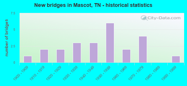
- New bridges - historical statistics
- 11900-1909
- 21910-1919
- 21920-1929
- 31930-1939
- 31940-1949
- 61950-1959
- 21960-1969
- 41970-1979
- 11990-1999

- Reconstructed bridges - Historical Statistics
- 31950-1959
- 11960-1969


- Bridge Condition - Deck
- 36.4%Good
- 27.3%Satisfactory
- 36.4%Fair

- Bridge Condition - Superstructure
- 9.1%Very good
- 36.4%Good
- 36.4%Satisfactory
- 18.2%Fair

- Bridge Condition - Substructure
- 9.1%Very good
- 9.1%Good
- 54.5%Satisfactory
- 27.3%Fair

- Bridge Condition - Channel
- 5.3%Very good
- 68.4%Good
- 10.5%Satisfactory
- 10.5%Fair
- 5.3%Poor

- Bridge Condition - Culverts
- 22.2%Good
- 55.6%Satisfactory
- 22.2%Fair
Find on map >> Show street view
Structure Number: 45SR0340001, Location: 1.2 M SW OF KNOX CO LN (Lat: 36.061417, Lng: -83.684017), Route carried "on" structure: US 11, Year Built: 1952, Status: Open, Structure Length: 0.99m (3.25ft), Average Daily Traffic: 15,538 (year 2020), Truck Traffic: 7%, Average Future Daily Traffic: 24,861 (year 2041), Design Load: HS 20, Features Intersected: CROWDER CREEK, Facility Carried by Structure: FAP 34
Minimum Vertical Clearance: 30+ m (98+ ft), Kilometerpoint: 0.837, Lanes on structure: 4, Base Highway Network: Yes, Owner: State Highway Agency, Approaching Roadway Width: 26.8m (87.9ft), Skew: 24 degrees, Material/Design: Concrete continuous, Design/Construction: Culvert, Number Of Spans In Main Unit: 2, Length of Maximum Span: 4.3m (14.1ft)
Condition: Channel: Good, Culverts: Satisfactory, Operating Rating: 77.4 metric tons, Method Used To Determine Operating Rating: Load Factor (LF), Inventory Rating: 32.4 metric tons, Method Used To Determine Inventory Rating: Load Factor (LF), Structural Evaluation: Equal to present minimum criteria, Waterway Adequacy: Better than present minimum criteria, Approach Roadway Alignment: Equal to present desirable criteria, Length Of Structure Improvement: 0.99m (3.25ft), Designated Inspection Frequency: Every 24 months, Inspection Date: October 2021, Bridge Improvement Cost: $321,000, Roadway Improvement Cost: $33,000, Total Project Cost: $482,000 ( Estimate for 2021)
Find on map >> Show street view
Structure Number: 47024280003, Location: N OF US11E-RUGGLES FERRY (Lat: 36.037583, Lng: -83.727017), Route carried "on" structure: County highway 2428, Year Built: 1955, Status: Open, Structure Length: 0.99m (3.25ft), Average Daily Traffic: 643 (year 2020), Truck Traffic: 3%, Average Future Daily Traffic: 1,008 (year 2040), Design Load: HS 20, Features Intersected: LYONS CREEK
Minimum Vertical Clearance: 30+ m (98+ ft), Kilometerpoint: 8.546, Lanes on structure: 2, Owner: County Highway Agency, Approaching Roadway Width: 6.4m (21.0ft), Material/Design: Concrete, Design/Construction: Culvert, Number Of Spans In Main Unit: 2, Length of Maximum Span: 4.6m (15.1ft)
Condition: Channel: Good, Culverts: Good, Operating Rating: 54.0 metric tons, Method Used To Determine Operating Rating: Field evaluation and documented engineering judgment, Inventory Rating: 32.4 metric tons, Method Used To Determine Inventory Rating: Field evaluation and documented engineering judgment, Structural Evaluation: Better than present minimum criteria, Waterway Adequacy: Better than present minimum criteria, Approach Roadway Alignment: Equal to present desirable criteria, Designated Inspection Frequency: Every 24 months, Inspection Date: May 2020
Find on map >> Show street view
Structure Number: 47024300003, Location: MILLERTOWN PK-W OFF US11W (Lat: 36.082517, Lng: -83.775933), Route carried "on" structure: County highway 2430, Year Built: 1965, Status: Open, Structure Length: 1.38m (4.53ft), Average Daily Traffic: 1,330 (year 2020), Truck Traffic: 4%, Average Future Daily Traffic: 2,240 (year 2040), Features Intersected: ROSEBERRY CREEK
Minimum Vertical Clearance: 30+ m (98+ ft), Kilometerpoint: 7.773, Lanes on structure: 2, Owner: County Highway Agency, Approaching Roadway Width: 6.4m (21.0ft), Skew: 2 degrees, Material/Design: Prestressed concrete, Design/Construction: Box Beam or Girders - Multiple, Number Of Spans In Main Unit: 1, Length of Maximum Span: 12.8m (42.0ft), Curb-To-Curb Width: 7.7m (25.3ft), Out-to-Out Width: 8.3m (27.2ft)
Condition: Deck: Good, Superstructure: Good, Substructure: Satisfactory, Channel: Good, Operating Rating: 44.1 metric tons, Method Used To Determine Operating Rating: Field evaluation and documented engineering judgment, Inventory Rating: 32.4 metric tons, Method Used To Determine Inventory Rating: Field evaluation and documented engineering judgment, Structural Evaluation: Equal to present minimum criteria, Deck Geometry: Meets minimum limits, Waterway Adequacy: Better than present minimum criteria, Approach Roadway Alignment: Equal to present desirable criteria, Designated Inspection Frequency: Every 24 months, Inspection Date: June 2020, Deck Structure Type: Other, Wearing Surface/Protective System: Wearing Surface: Bituminous
Find on map >> Show street view
Structure Number: 470D3990001, Location: E OFF US11W-2.5 M S OF CO (Lat: 36.100683, Lng: -83.741317), Route carried "on" structure: County highway 399, Year Built: 1975, Status: Open, Structure Length: 0.67m (2.20ft), Average Daily Traffic: 920 (year 2022), Truck Traffic: 2%, Average Future Daily Traffic: 1,472 (year 2040), Design Load: H 15, Features Intersected: BRICE BRANCH
Minimum Vertical Clearance: 30+ m (98+ ft), Kilometerpoint: 2.021, Lanes on structure: 2, Owner: County Highway Agency, Approaching Roadway Width: 5.8m (19.0ft), Material/Design: Steel, Design/Construction: Culvert, Number Of Spans In Main Unit: 2, Length of Maximum Span: 3.1m (10.2ft)
Condition: Channel: Good, Culverts: Fair, Operating Rating: 89.1 metric tons, Method Used To Determine Operating Rating: Load Factor (LF), Inventory Rating: 24.3 metric tons, Method Used To Determine Inventory Rating: Load Factor (LF), Structural Evaluation: Somewhat better than minimum adequacy, Waterway Adequacy: Equal to present minimum criteria, Approach Roadway Alignment: Equal to present desirable criteria, Designated Inspection Frequency: Every 24 months, Inspection Date: May 2020
Find on map >> Show street view
Structure Number: 470D4030001, Location: S OF CORRYTON (Lat: 36.123850, Lng: -83.774917), Route carried "on" structure: County highway 403, Year Built: 1973, Status: Open, Structure Length: 0.94m (3.08ft), Average Daily Traffic: 60 (year 2022), Truck Traffic: 1%, Average Future Daily Traffic: 96 (year 2040), Design Load: H 15, Features Intersected: LITTLE FLAT CREEK
Minimum Vertical Clearance: 30+ m (98+ ft), Kilometerpoint: 1.228, Lanes on structure: 2, Owner: County Highway Agency, Approaching Roadway Width: 5.5m (18.0ft), Material/Design: Steel, Design/Construction: Culvert, Number Of Spans In Main Unit: 2, Length of Maximum Span: 4.8m (15.7ft)
Condition: Channel: Good, Culverts: Good, Operating Rating: 89.1 metric tons, Method Used To Determine Operating Rating: Load Factor (LF), Inventory Rating: 24.3 metric tons, Method Used To Determine Inventory Rating: Load Factor (LF), Structural Evaluation: Equal to present minimum criteria, Waterway Adequacy: Equal to present minimum criteria, Approach Roadway Alignment: Equal to present desirable criteria, Length Of Structure Improvement: 0.94m (3.08ft), Designated Inspection Frequency: Every 24 months, Inspection Date: May 2020, Bridge Improvement Cost: $136,000, Roadway Improvement Cost: $14,000, Total Project Cost: $205,000 ( Estimate for 2020), Wearing Surface/Protective System: Wearing Surface: Bituminous
Find on map >> Show street view
Structure Number: 470D5760001, Location: MINE RD-NEAR MASCOT (Lat: 36.077633, Lng: -83.743133), Route carried "on" structure: County highway 1273, Year Built: 1950, Year Reconstructed: 1960, Status: Open, Structure Length: 2.63m (8.63ft), Average Daily Traffic: 4,039 (year 2020), Truck Traffic: 10%, Average Future Daily Traffic: 7,536 (year 2040), Features Intersected: FLAT CREEK
Minimum Vertical Clearance: 30+ m (98+ ft), Kilometerpoint: 1.561, Lanes on structure: 2, Owner: County Highway Agency, Approaching Roadway Width: 10.7m (35.1ft), Material/Design: Concrete, Design/Construction: Tee Beam, Number Of Spans In Main Unit: 2, Length of Maximum Span: 13.1m (43.0ft), Curb-To-Curb Width: 11.0m (36.1ft), Out-to-Out Width: 11.6m (38.1ft)
Condition: Deck: Fair, Superstructure: Satisfactory, Substructure: Satisfactory, Channel: Good, Operating Rating: 57.6 metric tons, Method Used To Determine Operating Rating: Load Factor (LF), Inventory Rating: 24.3 metric tons, Method Used To Determine Inventory Rating: Load Factor (LF), Structural Evaluation: Equal to present minimum criteria, Deck Geometry: Somewhat better than minimum adequacy, Waterway Adequacy: Equal to present minimum criteria, Approach Roadway Alignment: Equal to present desirable criteria, Designated Inspection Frequency: Every 24 months, Inspection Date: June 2020, Deck Structure Type: Concrete Cast-file-Place, Wearing Surface/Protective System: Wearing Surface: Bituminous
Find on map >> Show street view
Structure Number: 470D6040001, Location: JUST E OF US11W-US70 JCT (Lat: 36.027583, Lng: -83.724317), Route carried "on" structure: County highway 604, Year Built: 1964, Status: Open, Structure Length: 0.95m (3.12ft), Average Daily Traffic: 350 (year 2022), Truck Traffic: 2%, Average Future Daily Traffic: 560 (year 2040), Features Intersected: LYON CREEK
Minimum Vertical Clearance: 30+ m (98+ ft), Kilometerpoint: 0.106, Lanes on structure: 2, Owner: County Highway Agency, Approaching Roadway Width: 5.5m (18.0ft), Material/Design: Concrete, Design/Construction: Channel Beam, Number Of Spans In Main Unit: 2, Length of Maximum Span: 4.3m (14.1ft), Curb-To-Curb Width: 6.3m (20.7ft), Out-to-Out Width: 6.6m (21.7ft)
Condition: Deck: Satisfactory, Superstructure: Satisfactory, Substructure: Satisfactory, Channel: Good, Operating Rating: 36.0 metric tons, Method Used To Determine Operating Rating: Field evaluation and documented engineering judgment, Inventory Rating: 24.3 metric tons, Method Used To Determine Inventory Rating: Field evaluation and documented engineering judgment, Structural Evaluation: Equal to present minimum criteria, Deck Geometry: Meets minimum limits, Waterway Adequacy: Equal to present minimum criteria, Approach Roadway Alignment: Equal to present desirable criteria, Length Of Structure Improvement: 0.95m (3.12ft), Designated Inspection Frequency: Every 24 months, Inspection Date: May 2020, Bridge Improvement Cost: $80,000, Roadway Improvement Cost: $9,000, Total Project Cost: $121,000 ( Estimate for 2020), Deck Structure Type: Concrete Precast Panels, Wearing Surface/Protective System: Wearing Surface: Bituminous
Find on map >> Show street view
Structure Number: 470D8410001, Location: W OF US11W- (Lat: 36.078467, Lng: -83.770067), Route carried "on" structure: County highway 841, Year Built: 1915, Status: Open, Structure Length: 1.68m (5.51ft), Average Daily Traffic: 250 (year 2022), Truck Traffic: 2%, Average Future Daily Traffic: 400 (year 2040), Features Intersected: ROSEBERRY CREEK
Minimum Vertical Clearance: 30+ m (98+ ft), Kilometerpoint: 1.014, Lanes on structure: 2, Owner: County Highway Agency, Approaching Roadway Width: 4.9m (16.1ft), Skew: 1 degrees, Material/Design: Concrete continuous, Design/Construction: Arch - Deck, Number Of Spans In Main Unit: 2, Length of Maximum Span: 8.0m (26.2ft), Curb-To-Curb Width: 6.1m (20.0ft), Out-to-Out Width: 6.6m (21.7ft)
Condition: Deck: Fair, Superstructure: Fair, Substructure: Fair, Channel: Good, Operating Rating: 36.0 metric tons, Method Used To Determine Operating Rating: Field evaluation and documented engineering judgment, Inventory Rating: 24.3 metric tons, Method Used To Determine Inventory Rating: Field evaluation and documented engineering judgment, Structural Evaluation: Somewhat better than minimum adequacy, Deck Geometry: Meets minimum limits, Waterway Adequacy: Better than present minimum criteria, Approach Roadway Alignment: Equal to present desirable criteria, Length Of Structure Improvement: 1.68m (5.51ft), Designated Inspection Frequency: Every 24 months, Inspection Date: June 2020, Bridge Improvement Cost: $138,000, Roadway Improvement Cost: $14,000, Total Project Cost: $208,000 ( Estimate for 2020), Deck Structure Type: Concrete Cast-file-Place, Wearing Surface/Protective System: Wearing Surface: Bituminous
Find on map >> Show street view
Structure Number: 47F00250001, Location: ROBERTS RD-N OF US11W (Lat: 36.083117, Lng: -83.785733), Route carried "on" structure: County highway 1287, Year Built: 1939, Status: Posted for load, Structure Length: 1.66m (5.45ft), Average Daily Traffic: 2,281 (year 2020), Truck Traffic: 3%, Average Future Daily Traffic: 3,968 (year 2040), Features Intersected: ROSSBERRY CREEK
Minimum Vertical Clearance: 30+ m (98+ ft), Kilometerpoint: 1.642, Lanes on structure: 2, Owner: County Highway Agency, Approaching Roadway Width: 5.8m (19.0ft), Skew: 3 degrees, Material/Design: Steel, Design/Construction: Stringer/Multi-beam, Number Of Spans In Main Unit: 1, Length of Maximum Span: 14.9m (48.9ft), Curb-To-Curb Width: 6.1m (20.0ft), Out-to-Out Width: 6.7m (22.0ft)
Condition: Deck: Good, Superstructure: Satisfactory, Substructure: Satisfactory, Channel: Good, Operating Rating: 26.1 metric tons, Method Used To Determine Operating Rating: Load Factor (LF), Inventory Rating: 15.3 metric tons, Method Used To Determine Inventory Rating: Load Factor (LF), Structural Evaluation: Meets minimum limits, Deck Geometry: High priority of replacement, Waterway Adequacy: Better than present minimum criteria, Approach Roadway Alignment: Equal to present desirable criteria, Length Of Structure Improvement: 1.66m (5.45ft), Designated Inspection Frequency: Every 24 months, Inspection Date: June 2020, Bridge Improvement Cost: $257,000, Roadway Improvement Cost: $26,000, Total Project Cost: $386,000 ( Estimate for 2020), Deck Structure Type: Concrete Cast-file-Place, Wearing Surface/Protective System: Wearing Surface: Bituminous
Find on map >> Show street view
Structure Number: 47S24120005, Location: WASHINGTON PK-N OF US11W (Lat: 36.092783, Lng: -83.818133), Route carried "on" structure: County highway 1289, Year Built: 1940, Status: Open, Structure Length: 0.98m (3.22ft), Average Daily Traffic: 3,637 (year 2020), Truck Traffic: 3%, Average Future Daily Traffic: 5,968 (year 2040), Features Intersected: ROSEBERRY CREEK
Minimum Vertical Clearance: 30+ m (98+ ft), Kilometerpoint: 9.849, Lanes on structure: 2, Owner: County Highway Agency, Approaching Roadway Width: 5.5m (18.0ft), Material/Design: Concrete continuous, Design/Construction: Culvert, Number Of Spans In Main Unit: 2, Length of Maximum Span: 4.3m (14.1ft), Curb-To-Curb Width: 7.1m (23.3ft), Out-to-Out Width: 7.7m (25.3ft)
Condition: Channel: Good, Culverts: Fair, Operating Rating: 36.0 metric tons, Method Used To Determine Operating Rating: Field evaluation and documented engineering judgment, Inventory Rating: 24.3 metric tons, Method Used To Determine Inventory Rating: Field evaluation and documented engineering judgment, Structural Evaluation: Somewhat better than minimum adequacy, Deck Geometry: High priority of replacement, Waterway Adequacy: Equal to present minimum criteria, Approach Roadway Alignment: Equal to present desirable criteria, Length Of Structure Improvement: 0.98m (3.22ft), Designated Inspection Frequency: Every 24 months, Inspection Date: May 2020, Bridge Improvement Cost: $133,000, Roadway Improvement Cost: $14,000, Total Project Cost: $200,000 ( Estimate for 2020), Wearing Surface/Protective System: Wearing Surface: Bituminous
Find on map >> Show street view
Structure Number: 47S25050001, Location: JUST W OF MASCOT (Lat: 36.064450, Lng: -83.757300), Route carried "on" structure: County highway 1262, Year Built: 1997, Status: Open, Structure Length: 7.74m (25.39ft), Average Daily Traffic: 1,811 (year 2020), Truck Traffic: 3%, Average Future Daily Traffic: 3,136 (year 2040), Features Intersected: ROSEBERRY CREEK
Minimum Vertical Clearance: 30+ m (98+ ft), Kilometerpoint: 2.639, Lanes on structure: 2, Owner: County Highway Agency, Approaching Roadway Width: 12.2m (40.0ft), Material/Design: Prestressed concrete continuous, Design/Construction: Stringer/Multi-beam, Number Of Spans In Main Unit: 3, Length of Maximum Span: 25.9m (85.0ft), Curb-To-Curb Width: 12.2m (40.0ft), Out-to-Out Width: 12.8m (42.0ft)
Condition: Deck: Good, Superstructure: Very good, Substructure: Very good, Channel: Very good, Operating Rating: 64.8 metric tons, Method Used To Determine Operating Rating: Load Factor (LF), Inventory Rating: 31.5 metric tons, Method Used To Determine Inventory Rating: Load Factor (LF), Structural Evaluation: Better than present minimum criteria, Deck Geometry: Better than present minimum criteria, Waterway Adequacy: Superior to present desirable criteria, Approach Roadway Alignment: Equal to present desirable criteria, Designated Inspection Frequency: Every 24 months, Inspection Date: June 2020, Deck Structure Type: Concrete Precast Panels, Wearing Surface/Protective System: Wearing Surface: Monolithic Concrete, Deck Protection: Epoxy Coated Reinforcing
Find on map >> Show street view
Structure Number: 47S25050003, Location: IN MASCOT (Lat: 36.061750, Lng: -83.745733), Route carried "on" structure: County highway 1262, Year Built: 1927, Status: Open, Structure Length: 2.22m (7.28ft), Average Daily Traffic: 1,811 (year 2020), Truck Traffic: 3%, Average Future Daily Traffic: 3,136 (year 2040), Features Intersected: FLAT CREEK
Minimum Vertical Clearance: 30+ m (98+ ft), Kilometerpoint: 3.991, Lanes on structure: 2, Owner: County Highway Agency, Approaching Roadway Width: 4.3m (14.1ft), Material/Design: Concrete, Design/Construction: Arch - Deck, Number Of Spans In Main Unit: 1, Length of Maximum Span: 19.7m (64.6ft), Curb-To-Curb Width: 5.4m (17.7ft), Out-to-Out Width: 5.9m (19.4ft)
Condition: Deck: Satisfactory, Superstructure: Satisfactory, Substructure: Fair, Channel: Satisfactory, Operating Rating: 36.0 metric tons, Method Used To Determine Operating Rating: Field evaluation and documented engineering judgment, Inventory Rating: 24.3 metric tons, Method Used To Determine Inventory Rating: Field evaluation and documented engineering judgment, Structural Evaluation: Somewhat better than minimum adequacy, Deck Geometry: High priority of replacement, Waterway Adequacy: Better than present minimum criteria, Approach Roadway Alignment: High priority of corrective action, Length Of Structure Improvement: 2.22m (7.28ft), Designated Inspection Frequency: Every 24 months, Inspection Date: June 2020, Bridge Improvement Cost: $297,000, Roadway Improvement Cost: $30,000, Total Project Cost: $446,000 ( Estimate for 2020), Deck Structure Type: Concrete Cast-file-Place, Wearing Surface/Protective System: Wearing Surface: Bituminous
Find on map >> Show street view
Structure Number: 47S25050009, Location: N OF US11E-NEAR CO LINE (Lat: 36.059717, Lng: -83.704050), Route carried "on" structure: County highway 1262, Year Built: 1930, Status: Open, Structure Length: 23.93m (78.51ft), Average Daily Traffic: 8,306 (year 2020), Truck Traffic: 3%, Average Future Daily Traffic: 11,456 (year 2041), Features Intersected: HOLSTON RIVER
Minimum Vertical Clearance: 5.47m (17.95ft), Kilometerpoint: 8.336, Lanes on structure: 2, Owner: County Highway Agency, Approaching Roadway Width: 12.2m (40.0ft), Material/Design: Concrete, Design/Construction: Arch - Thru, Number Of Spans In Main Unit: 3, Number Of Approach Spans: 5, Length of Maximum Span: 67.8m (222.4ft), Curb-To-Curb Width: 7.5m (24.6ft), Out-to-Out Width: 10.3m (33.8ft)
Condition: Deck: Fair, Superstructure: Fair, Substructure: Fair, Channel: Good, Operating Rating: 36.0 metric tons, Method Used To Determine Operating Rating: Field evaluation and documented engineering judgment, Inventory Rating: 24.3 metric tons, Method Used To Determine Inventory Rating: Field evaluation and documented engineering judgment, Structural Evaluation: Somewhat better than minimum adequacy, Deck Geometry: High priority of replacement, Waterway Adequacy: Better than present minimum criteria, Approach Roadway Alignment: Equal to present desirable criteria, Length Of Structure Improvement: 23.93m (78.51ft), Designated Inspection Frequency: Every 24 months, Underwater Inspection Frequency: Every 60 months, Inspection Date: May 2020, Underwater Inspection Date: October 2016, Bridge Improvement Cost: $9,677,000, Roadway Improvement Cost: $968,000, Total Project Cost: $14,516,000 ( Estimate for 2021), Deck Structure Type: Concrete Cast-file-Place, Wearing Surface/Protective System: Wearing Surface: Bituminous
Find on map >> Show street view
Structure Number: 47SR0010045, Location: 1 M NE OF THREE POINTS (Lat: 36.056300, Lng: -83.792117), Route carried "on" structure: US 11, Year Built: 1976, Status: Open, Structure Length: 0.93m (3.05ft), Average Daily Traffic: 13,147 (year 2020), Truck Traffic: 15%, Average Future Daily Traffic: 21,035 (year 2041), Design Load: H 15, Features Intersected: STRONG CREEK, Facility Carried by Structure: FAP 1
Minimum Vertical Clearance: 30+ m (98+ ft), Kilometerpoint: 49.314, Lanes on structure: 4, Base Highway Network: Yes, Owner: State Highway Agency, Approaching Roadway Width: 28.0m (91.9ft), Material/Design: Concrete continuous, Design/Construction: Culvert, Number Of Spans In Main Unit: 2, Length of Maximum Span: 3.8m (12.5ft)
Condition: Channel: Good, Culverts: Satisfactory, Operating Rating: 89.1 metric tons, Method Used To Determine Operating Rating: Load Factor (LF), Inventory Rating: 32.4 metric tons, Method Used To Determine Inventory Rating: Load Factor (LF), Structural Evaluation: Equal to present minimum criteria, Waterway Adequacy: Better than present minimum criteria, Approach Roadway Alignment: Equal to present desirable criteria, Length Of Structure Improvement: 0.93m (3.05ft), Designated Inspection Frequency: Every 24 months, Inspection Date: September 2021, Bridge Improvement Cost: $277,000, Roadway Improvement Cost: $28,000, Total Project Cost: $416,000 ( Estimate for 2021)
Find on map >> Show street view
Structure Number: 47SR0010047, Location: 1.4 M SE OF MASCOT (Lat: 36.077933, Lng: -83.768117), Route carried "on" structure: US 11, Year Built: 1973, Status: Open, Structure Length: 1.27m (4.17ft), Average Daily Traffic: 10,981 (year 2020), Truck Traffic: 7%, Average Future Daily Traffic: 17,570 (year 2041), Design Load: H 15, Features Intersected: ROSEBERRY CREEK, Facility Carried by Structure: FAP 1
Minimum Vertical Clearance: 30+ m (98+ ft), Kilometerpoint: 52.565, Lanes on structure: 2, Owner: State Highway Agency, Approaching Roadway Width: 23.4m (76.8ft), Skew: 1 degrees, Material/Design: Concrete continuous, Design/Construction: Culvert, Number Of Spans In Main Unit: 3, Length of Maximum Span: 3.7m (12.1ft)
Condition: Channel: Good, Culverts: Satisfactory, Operating Rating: 89.1 metric tons, Method Used To Determine Operating Rating: Load Factor (LF), Inventory Rating: 32.4 metric tons, Method Used To Determine Inventory Rating: Load Factor (LF), Structural Evaluation: Equal to present minimum criteria, Waterway Adequacy: Equal to present minimum criteria, Approach Roadway Alignment: Equal to present desirable criteria, Designated Inspection Frequency: Every 24 months, Inspection Date: September 2021
Find on map >> Show street view
Structure Number: 47SR0010053, Location: 2.4 MI SW GRAINGER CO. (Lat: 36.102900, Lng: -83.743467), Route carried "on" structure: US 11, Year Built: 1955, Status: Open, Structure Length: 0.68m (2.23ft), Average Daily Traffic: 10,981 (year 2020), Truck Traffic: 7%, Average Future Daily Traffic: 17,570 (year 2041), Design Load: HS 20+Mod, Features Intersected: BRANCH, Facility Carried by Structure: FAP 1
Minimum Vertical Clearance: 30+ m (98+ ft), Kilometerpoint: 56.121, Lanes on structure: 2, Base Highway Network: Yes, Owner: State Highway Agency, Approaching Roadway Width: 8.5m (27.9ft), Material/Design: Concrete continuous, Design/Construction: Culvert, Number Of Spans In Main Unit: 2, Length of Maximum Span: 3.0m (9.8ft)
Condition: Channel: Fair, Culverts: Satisfactory, Operating Rating: 34.2 metric tons, Method Used To Determine Operating Rating: Load Factor (LF), Inventory Rating: 25.2 metric tons, Method Used To Determine Inventory Rating: Load Factor (LF), Structural Evaluation: Equal to present minimum criteria, Waterway Adequacy: Equal to present minimum criteria, Approach Roadway Alignment: Equal to present desirable criteria, Designated Inspection Frequency: Every 24 months, Inspection Date: September 2021
Find on map >> Show street view
Structure Number: 47SR0090013, Location: 2.5 M E OF STRINGTOWN RD (Lat: 36.027467, Lng: -83.734050), Route carried "on" structure: Ramp US 25, Year Built: 1933, Year Reconstructed: 1964, Status: Open, Structure Length: 6.72m (22.05ft), Average Daily Traffic: 4,811 (year 2020), Truck Traffic: 4%, Average Future Daily Traffic: 7,698 (year 2041), Design Load: HS 20, Features Intersected: SR9-ASHEVILLE / SR 34, Facility Carried by Structure: FAS 9
Minimum Vertical Clearance: 30+ m (98+ ft), Kilometerpoint: 21.549, Lanes on structure: 1, Lanes under structure: 4, Owner: State Highway Agency, Approaching Roadway Width: 8.2m (26.9ft), Skew: 4 degrees, Material/Design: Concrete, Design/Construction: Tee Beam, Number Of Spans In Main Unit: 4, Length of Maximum Span: 20.6m (67.6ft), Curb-To-Curb Width: 7.6m (24.9ft), Out-to-Out Width: 10.6m (34.8ft)
Condition: Deck: Good, Superstructure: Good, Substructure: Good, Operating Rating: 45.0 metric tons, Method Used To Determine Operating Rating: Load Factor (LF), Inventory Rating: 27.0 metric tons, Method Used To Determine Inventory Rating: Load Factor (LF), Structural Evaluation: Equal to present minimum criteria, Deck Geometry: Better than present minimum criteria, Underclear: Meets minimum limits, Approach Roadway Alignment: Equal to present minimum criteria, Length Of Structure Improvement: 6.72m (22.05ft), Designated Inspection Frequency: Every 24 months, Inspection Date: September 2021, Bridge Improvement Cost: $1,097,000, Roadway Improvement Cost: $110,000, Total Project Cost: $1,646,000 ( Estimate for 2021), Deck Structure Type: Concrete Cast-file-Place, Wearing Surface/Protective System: Wearing Surface: Bituminous
Find on map >> Show street view
Structure Number: 47SR0340001, Location: NORTH OF TRENTSVILLE (Lat: 36.033683, Lng: -83.726150), Route carried "on" structure: US 11, Year Built: 1942, Year Reconstructed: 1955, Status: Open, Structure Length: 1.76m (5.77ft), Average Daily Traffic: 17,162 (year 2020), Truck Traffic: 4%, Average Future Daily Traffic: 27,459 (year 2041), Design Load: HS 20, Features Intersected: LYONS CREEK, Facility Carried by Structure: FAP 34
Minimum Vertical Clearance: 30+ m (98+ ft), Kilometerpoint: 1.304, Lanes on structure: 4, Owner: State Highway Agency, Approaching Roadway Width: 20.4m (66.9ft), Skew: 23 degrees, Material/Design: Concrete, Design/Construction: Tee Beam, Number Of Spans In Main Unit: 2, Length of Maximum Span: 8.9m (29.2ft), Curb-To-Curb Width: 20.4m (66.9ft), Out-to-Out Width: 31.8m (104.3ft)
Condition: Deck: Satisfactory, Superstructure: Good, Substructure: Satisfactory, Channel: Fair, Operating Rating: 43.2 metric tons, Method Used To Determine Operating Rating: Load Factor (LF), Inventory Rating: 26.1 metric tons, Method Used To Determine Inventory Rating: Load Factor (LF), Structural Evaluation: Equal to present minimum criteria, Deck Geometry: Superior to present desirable criteria, Waterway Adequacy: Better than present minimum criteria, Approach Roadway Alignment: Equal to present desirable criteria, Length Of Structure Improvement: 1.76m (5.77ft), Designated Inspection Frequency: Every 24 months, Inspection Date: November 2021, Bridge Improvement Cost: $799,000, Roadway Improvement Cost: $80,000, Total Project Cost: $1,199,000 ( Estimate for 2021), Deck Structure Type: Concrete Cast-file-Place, Wearing Surface/Protective System: Wearing Surface: Bituminous
Find on map >> Show street view
Structure Number: 47SR0340003, Location: NEAR KNOXVILLE (Lat: 36.046517, Lng: -83.711200), Route carried "on" structure: US 11, Year Built: 1942, Year Reconstructed: 1955, Status: Open, Structure Length: 0.87m (2.85ft), Average Daily Traffic: 17,162 (year 2020), Truck Traffic: 4%, Average Future Daily Traffic: 27,459 (year 2041), Design Load: HS 20, Features Intersected: CLIFTS CREEK, Facility Carried by Structure: FAP 34
Minimum Vertical Clearance: 30+ m (98+ ft), Kilometerpoint: 3.267, Lanes on structure: 4, Base Highway Network: Yes, Owner: State Highway Agency, Approaching Roadway Width: 19.8m (65.0ft), Skew: 20 degrees, Material/Design: Concrete, Design/Construction: Tee Beam, Number Of Spans In Main Unit: 1, Length of Maximum Span: 7.9m (25.9ft), Curb-To-Curb Width: 20.8m (68.2ft), Out-to-Out Width: 31.9m (104.7ft)
Condition: Deck: Fair, Superstructure: Good, Substructure: Satisfactory, Channel: Satisfactory, Operating Rating: 38.7 metric tons, Method Used To Determine Operating Rating: Load Factor (LF), Inventory Rating: 23.4 metric tons, Method Used To Determine Inventory Rating: Load Factor (LF), Structural Evaluation: Somewhat better than minimum adequacy, Deck Geometry: Superior to present desirable criteria, Waterway Adequacy: Equal to present desirable criteria, Approach Roadway Alignment: Equal to present desirable criteria, Length Of Structure Improvement: 0.87m (2.85ft), Designated Inspection Frequency: Every 24 months, Inspection Date: November 2021, Bridge Improvement Cost: $418,000, Roadway Improvement Cost: $42,000, Total Project Cost: $628,000 ( Estimate for 2021), Deck Structure Type: Concrete Cast-file-Place, Wearing Surface/Protective System: Wearing Surface: Bituminous
Find on map >> Show street view
Structure Number: 47SR0340005, Location: .18 MI.W.OF JEFFERSON CO. (Lat: 36.056833, Lng: -83.694867), Route carried "on" structure: US 11, Year Built: 1953, Status: Open, Structure Length: 0.70m (2.30ft), Average Daily Traffic: 15,538 (year 2020), Truck Traffic: 7%, Average Future Daily Traffic: 24,861 (year 2041), Design Load: HS 20, Features Intersected: THOMPSON CREEK, Facility Carried by Structure: FAP 34
Minimum Vertical Clearance: 30+ m (98+ ft), Kilometerpoint: 5.230, Lanes on structure: 4, Base Highway Network: Yes, Owner: State Highway Agency, Approaching Roadway Width: 22.1m (72.5ft), Skew: 21 degrees, Material/Design: Concrete continuous, Design/Construction: Culvert, Number Of Spans In Main Unit: 2, Length of Maximum Span: 3.1m (10.2ft)
Condition: Channel: Poor, Culverts: Satisfactory, Operating Rating: 54.0 metric tons, Method Used To Determine Operating Rating: Field evaluation and documented engineering judgment, Inventory Rating: 32.4 metric tons, Method Used To Determine Inventory Rating: Field evaluation and documented engineering judgment, Structural Evaluation: Equal to present minimum criteria, Waterway Adequacy: Equal to present minimum criteria, Approach Roadway Alignment: Equal to present desirable criteria, Length Of Structure Improvement: 0.70m (2.30ft), Designated Inspection Frequency: Every 24 months, Inspection Date: November 2021, Bridge Improvement Cost: $234,000, Roadway Improvement Cost: $24,000, Total Project Cost: $352,000 ( Estimate for 2021)
Find on map >> Show street view
Structure Number: 45024550001, Location: N OF US11E AT KNOX CO LI (Lat: 36.062983, Lng: -83.691100), Route carried "under" structure: County highway 2455, Year Built: 1907, Structure Length: 0. m, Average Daily Traffic: 237 (year 2020), Truck Traffic: 3%, Features Intersected: SOUTHERN RAILWAY, Facility Carried by Structure: SOU RWY 731440J
Minimum Vertical Clearance: 5.36m (17.59ft), Kilometerpoint: 0.821, Lanes under structure: 2, Material/Design: Steel, Design/Construction: Stringer/Multi-beam, Length of Maximum Span: 26.8m (87.9ft)
Find on map >> Show street view
Structure Number: 450A0880001, Location: IN STRAWBERRY PLAINS (Lat: 36.064150, Lng: -83.686650), Route carried "under" structure: County highway 88, Year Built: 1926, Structure Length: 0. m, Average Daily Traffic: 970 (year 2022), Truck Traffic: 2%, Features Intersected: SOUTHERN RAILWAY, Facility Carried by Structure: SOU RWY 731439P
Minimum Vertical Clearance: 2.70m (8.86ft), Kilometerpoint: 0.000, Lanes under structure: 1, Material/Design: Concrete, Design/Construction: Slab, Length of Maximum Span: 4.9m (16.1ft)
Find on map >> Show street view
Structure Number: 47012620007, Location: IN MASCOT (Lat: 36.061750, Lng: -83.745250), Route carried "under" structure: County highway 1262, Year Built: 1910, Structure Length: 0. m, Average Daily Traffic: 1,811 (year 2020), Truck Traffic: 3%, Features Intersected: ERN RR / MASCOT PK, Facility Carried by Structure: SOU RWY 731443E
Minimum Vertical Clearance: 2.44m (8.01ft), Kilometerpoint: 4.039, Lanes under structure: 2, Material/Design: Concrete, Design/Construction: Arch - Deck, Length of Maximum Span: 6.1m (20.0ft)
Find on map >> Show street view
Structure Number: 47SR0090013, Location: NEAR KNOXVILLE TENN. (Lat: 36.027467, Lng: -83.734050), Route carried "under" structure: US 11, Year Built: 1957, Structure Length: 0. m, Average Daily Traffic: 17,162 (year 2020), Truck Traffic: 4%, Features Intersected: SR9-ASHEVILLE / SR 34, Facility Carried by Structure: FAS 9 WBL
Minimum Vertical Clearance: 4.47m (14.67ft), Kilometerpoint: 0.370, Lanes on structure: 1, Lanes under structure: 4, Material/Design: Concrete, Design/Construction: Tee Beam, Length of Maximum Span: 20.6m (67.6ft)