Bridge Statistics for Mason, Michigan (MI)
Condition, Traffic, Stress, Structural Evaluation, Project Costs
- National Bridge Inventory (NBI) Statistics
- 31Number of bridges
- 259ft / 79.4mTotal length
- $295,000Total costs
- 279,515Total average daily traffic
- 17,338Total average daily truck traffic
- National Bridge Inventory (NBI) Registered Bridges for Mason
- No street view available for this location
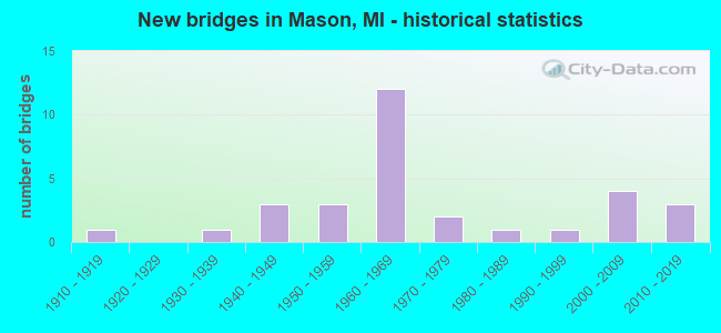
- New bridges - historical statistics
- 11910-1919
- 11930-1939
- 31940-1949
- 31950-1959
- 121960-1969
- 21970-1979
- 11980-1989
- 11990-1999
- 42000-2009
- 32010-2019
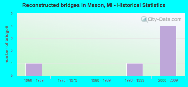
- Reconstructed bridges - Historical Statistics
- 11960-1969
- 01970-1979
- 01980-1989
- 11990-1999
- 42000-2009
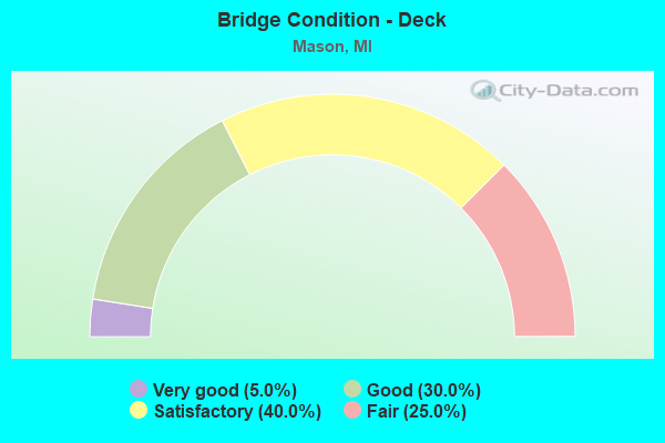
- Bridge Condition - Deck
- 5.0%Very good
- 30.0%Good
- 40.0%Satisfactory
- 25.0%Fair
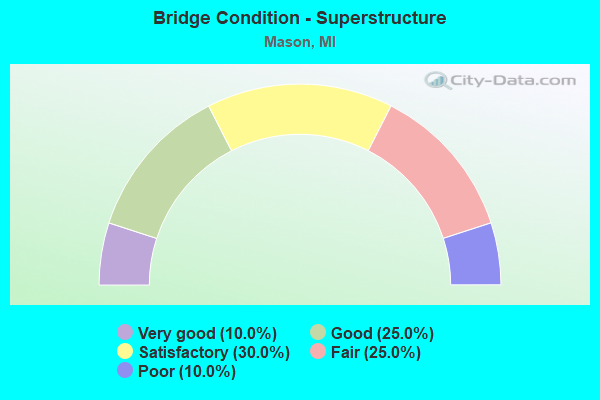
- Bridge Condition - Superstructure
- 10.0%Very good
- 25.0%Good
- 30.0%Satisfactory
- 25.0%Fair
- 10.0%Poor
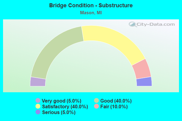
- Bridge Condition - Substructure
- 5.0%Very good
- 40.0%Good
- 40.0%Satisfactory
- 10.0%Fair
- 5.0%Serious
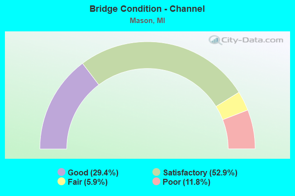
- Bridge Condition - Channel
- 29.4%Good
- 52.9%Satisfactory
- 5.9%Fair
- 11.8%Poor
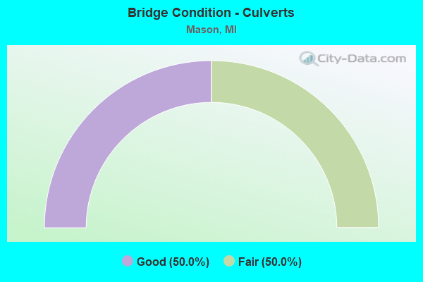
- Bridge Condition - Culverts
- 50.0%Good
- 50.0%Fair
Find on map >> Show street view
Structure Number: 371, Location: 0.5 MI N OF SCHUSS MTN (Lat: 44.968656, Lng: -85.138961), Route carried "on" structure: County highway , Year Built: 2005, Status: Open, Structure Length: 2.13m (6.99ft), Average Daily Traffic: 90 (year 2004), Truck Traffic: 2%, Average Future Daily Traffic: 160 (year 2024), Design Load: HS 20+Mod, Features Intersected: CEDAR RIVER, Facility Carried by Structure: STOVER BRIDGE RD
Minimum Vertical Clearance: 30.48m (100.00ft), Kilometerpoint: 4.905, Lanes on structure: 2, Owner: County Highway Agency, Approaching Roadway Width: 7.9m (25.9ft), Material/Design: Wood or Timber, Design/Construction: Slab, Number Of Spans In Main Unit: 3, Length of Maximum Span: 9.1m (29.9ft), Curb or Sidewalk Widths: Left: 0.2m (0.7ft), Right: 0.2m (0.7ft), Curb-To-Curb Width: 7.9m (25.9ft), Out-to-Out Width: 8.7m (28.5ft)
Condition: Deck: Very good, Superstructure: Very good, Substructure: Good, Channel: Good, Operating Rating: 81.0 metric tons, Method Used To Determine Operating Rating: Allowable Stress (AS) rating reported by rating factor (RF) method using MS18 loading, Inventory Rating: 58.0 metric tons, Method Used To Determine Inventory Rating: Allowable Stress (AS) rating reported by rating factor (RF) method using MS18 loading, Structural Evaluation: Better than present minimum criteria, Deck Geometry: Equal to present minimum criteria, Waterway Adequacy: Equal to present desirable criteria, Approach Roadway Alignment: Equal to present desirable criteria, Designated Inspection Frequency: Every 24 months, Inspection Date: September 2020, Deck Structure Type: Wood or Timber, Wearing Surface/Protective System: Wearing Surface: Bituminous
Find on map >> Show street view
Structure Number: 372, Location: 0.2 MI W OF M-88 (Lat: 44.975408, Lng: -85.213025), Route carried "on" structure: City street 538, Year Built: 1977, Status: Posted for load, Structure Length: 2.80m (9.19ft), Average Daily Traffic: 3,000 (year 2010), Truck Traffic: 7%, Average Future Daily Traffic: 4,500 (year 2030), Design Load: HS 20+Mod, Features Intersected: INTERMEDIATE RIVER, Facility Carried by Structure: CAYUGA STREET
Minimum Vertical Clearance: 30.48m (100.00ft), Kilometerpoint: 5.800, Lanes on structure: 2, Owner: City or Municipal Highway Agency, Approaching Roadway Width: 9.1m (29.9ft), Material/Design: Prestressed concrete, Design/Construction: Box Beam or Girders - Multiple, Number Of Spans In Main Unit: 2, Length of Maximum Span: 14.0m (45.9ft), Curb-To-Curb Width: 10.8m (35.4ft), Out-to-Out Width: 11.7m (38.4ft)
Condition: Deck: Good, Superstructure: Fair, Substructure: Satisfactory, Channel: Good, Operating Rating: 36.3 metric tons, Method Used To Determine Operating Rating: Load Factor (LF) rating reported by rating factor (RF) method using MS18 loading, Inventory Rating: 21.7 metric tons, Method Used To Determine Inventory Rating: Load Factor (LF) rating reported by rating factor (RF) method using MS18 loading, Structural Evaluation: Somewhat better than minimum adequacy, Deck Geometry: Somewhat better than minimum adequacy, Waterway Adequacy: Superior to present desirable criteria, Approach Roadway Alignment: Equal to present desirable criteria, Bridge Posting: Required (Relationship of Operating Rating to Maximum Legal Load: 20.0 - 29.9% below), Designated Inspection Frequency: Every 24 months, Inspection Date: May 2020, Deck Structure Type: Concrete Precast Panels, Wearing Surface/Protective System: Wearing Surface: Bituminous, Membrane: Preformed Fabric
Find on map >> Show street view
Structure Number: 3695, Location: IN MASON (ASH ST) (Lat: 42.579181, Lng: -84.447464), Route carried "on" structure: State highway 36, Year Built: 1918, Status: Open, Structure Length: 0.88m (2.89ft), Average Daily Traffic: 5,910 (year 2015), Truck Traffic: 3%, Average Future Daily Traffic: 6,829 (year 2018), Design Load: HS 20, Features Intersected: SYCAMORE CREEK
Minimum Vertical Clearance: 30.48m (100.00ft), Kilometerpoint: 0.793, Lanes on structure: 2, Owner: State Highway Agency, Approaching Roadway Width: 11.0m (36.1ft), Skew: 1 degrees, Material/Design: Concrete, Design/Construction: Tee Beam, Number Of Spans In Main Unit: 1, Length of Maximum Span: 8.8m (28.9ft), Curb or Sidewalk Widths: Left: 1.8m (5.9ft), Right: 1.8m (5.9ft), Curb-To-Curb Width: 11.0m (36.1ft), Out-to-Out Width: 15.4m (50.5ft)
Condition: Deck: Fair, Superstructure: Poor, Substructure: Fair, Channel: Satisfactory, Operating Rating: 54.1 metric tons, Method Used To Determine Operating Rating: Load Factor (LF) rating reported by rating factor (RF) method using MS18 loading, Inventory Rating: 32.4 metric tons, Method Used To Determine Inventory Rating: Load Factor (LF) rating reported by rating factor (RF) method using MS18 loading, Structural Evaluation: Meets minimum limits, Deck Geometry: Meets minimum limits, Waterway Adequacy: High priority of corrective action, Approach Roadway Alignment: High priority of corrective action, Designated Inspection Frequency: Every 12 months, Inspection Date: July 2021, Deck Structure Type: Concrete Cast-file-Place, Wearing Surface/Protective System: Wearing Surface: Bituminous
Find on map >> Show street view
Structure Number: 3697, Location: 3.5 MI S OF M-36 (Lat: 42.548328, Lng: -84.443267), Route carried "on" structure: US 127, Year Built: 1956, Status: Open, Structure Length: 0.79m (2.59ft), Average Daily Traffic: 31,200 (year 2012), Truck Traffic: 6%, Average Future Daily Traffic: 38,000 (year 2032), Design Load: HS 20, Features Intersected: SYCAMORE CREEK
Minimum Vertical Clearance: 30.48m (100.00ft), Kilometerpoint: 14.216, Lanes on structure: 4, Base Highway Network: Yes (Inventory Route: 35, Subroute: 9), Owner: State Highway Agency, Approaching Roadway Width: 31.1m (102.0ft), Skew: 11 degrees, Material/Design: Concrete, Design/Construction: Tee Beam, Number Of Spans In Main Unit: 1, Length of Maximum Span: 7.9m (25.9ft), Curb-To-Curb Width: 31.1m (102.0ft), Out-to-Out Width: 39.6m (129.9ft)
Condition: Deck: Good, Superstructure: Good, Substructure: Satisfactory, Channel: Satisfactory, Operating Rating: 63.8 metric tons, Method Used To Determine Operating Rating: Load Factor (LF) rating reported by rating factor (RF) method using MS18 loading, Inventory Rating: 38.6 metric tons, Method Used To Determine Inventory Rating: Load Factor (LF) rating reported by rating factor (RF) method using MS18 loading, Structural Evaluation: Equal to present minimum criteria, Deck Geometry: Superior to present desirable criteria, Waterway Adequacy: Equal to present desirable criteria, Approach Roadway Alignment: Equal to present minimum criteria, Designated Inspection Frequency: Every 24 months, Inspection Date: June 2020, Deck Structure Type: Concrete Cast-file-Place, Wearing Surface/Protective System: Wearing Surface: Bituminous
Find on map >> Show street view
Structure Number: 3704, Location: 5.1 MI S OF M-36 (Lat: 42.524075, Lng: -84.443228), Route carried "on" structure: County highway 3330, Year Built: 1966, Year Reconstructed: 2014, Status: Open, Structure Length: 5.09m (16.70ft), Average Daily Traffic: 4,600 (year 2012), Truck Traffic: 1%, Average Future Daily Traffic: 5,600 (year 2032), Design Load: H 15, Features Intersected: US-127, Facility Carried by Structure: BARNES RD
Minimum Vertical Clearance: 30.48m (100.00ft), Kilometerpoint: 13.183, Lanes on structure: 2, Lanes under structure: 4, Owner: State Highway Agency, Approaching Roadway Width: 11.0m (36.1ft), Material/Design: Steel continuous, Design/Construction: Stringer/Multi-beam, Number Of Spans In Main Unit: 2, Length of Maximum Span: 25.1m (82.3ft), Curb-To-Curb Width: 8.5m (27.9ft), Out-to-Out Width: 10.5m (34.4ft)
Condition: Deck: Fair, Superstructure: Fair, Substructure: Satisfactory, Operating Rating: 60.3 metric tons, Method Used To Determine Operating Rating: Load Factor (LF) rating reported by rating factor (RF) method using MS18 loading, Inventory Rating: 36.3 metric tons, Method Used To Determine Inventory Rating: Load Factor (LF) rating reported by rating factor (RF) method using MS18 loading, Structural Evaluation: Somewhat better than minimum adequacy, Deck Geometry: Meets minimum limits, Underclear: Somewhat better than minimum adequacy, Approach Roadway Alignment: Equal to present minimum criteria, Designated Inspection Frequency: Every 24 months, Inspection Date: June 2020, Deck Structure Type: Concrete Cast-file-Place, Wearing Surface/Protective System: Wearing Surface: Latex Concrete
Find on map >> Show street view
Structure Number: 371, Location: S LTS OF MASON (Lat: 42.567661, Lng: -84.449797), Route carried "on" structure: County highway 2068, Year Built: 2011, Status: Open, Structure Length: 7.53m (24.70ft), Average Daily Traffic: 6,700 (year 1997), Truck Traffic: 5%, Average Future Daily Traffic: 7,400 (year 2031), Design Load: HL 93, Features Intersected: US-127, Facility Carried by Structure: KIPP RD
Minimum Vertical Clearance: 30.48m (100.00ft), Kilometerpoint: 4.564, Lanes on structure: 2, Lanes under structure: 4, Owner: State Highway Agency, Approaching Roadway Width: 13.4m (44.0ft), Skew: 3 degrees, Material/Design: Steel continuous, Design/Construction: Stringer/Multi-beam, Number Of Spans In Main Unit: 2, Length of Maximum Span: 36.7m (120.4ft), Curb or Sidewalk Widths: Left: 1.5m (4.9ft), Right: 0.0m, Curb-To-Curb Width: 13.4m (44.0ft), Out-to-Out Width: 15.9m (52.2ft)
Condition: Deck: Good, Superstructure: Good, Substructure: Good, Operating Rating: 63.5 metric tons, Method Used To Determine Operating Rating: Load and Resistance Factor Rating (LRFR) rating reported by rating factor(RF) method using HL-93 loadings, Inventory Rating: 48.9 metric tons, Method Used To Determine Inventory Rating: Load and Resistance Factor Rating (LRFR) rating reported by rating factor(RF) method using HL-93 loadings, Structural Evaluation: Better than present minimum criteria, Deck Geometry: Equal to present minimum criteria, Underclear: Equal to present minimum criteria, Approach Roadway Alignment: Equal to present desirable criteria, Designated Inspection Frequency: Every 24 months, Inspection Date: June 2020, Deck Structure Type: Concrete Cast-file-Place, Wearing Surface/Protective System: Wearing Surface: Monolithic Concrete, Deck Protection: Epoxy Coated Reinforcing
Find on map >> Show street view
Structure Number: 3711, Location: IN MASON (Lat: 42.581803, Lng: -84.460075), Route carried "on" structure: City street 2068, Year Built: 1966, Year Reconstructed: 2014, Status: Open, Structure Length: 5.38m (17.65ft), Average Daily Traffic: 5,327 (year 2019), Truck Traffic: 4%, Average Future Daily Traffic: 6,126 (year 2039), Design Load: H 20, Features Intersected: US-127, Facility Carried by Structure: COLUMBIA RD
Minimum Vertical Clearance: 30.48m (100.00ft), Kilometerpoint: 11.803, Lanes on structure: 2, Lanes under structure: 4, Owner: State Highway Agency, Approaching Roadway Width: 12.2m (40.0ft), Skew: 2 degrees, Material/Design: Steel, Design/Construction: Stringer/Multi-beam, Number Of Spans In Main Unit: 4, Length of Maximum Span: 16.4m (53.8ft), Curb-To-Curb Width: 11.2m (36.7ft), Out-to-Out Width: 12.8m (42.0ft)
Condition: Deck: Satisfactory, Superstructure: Satisfactory, Substructure: Good, Operating Rating: 53.1 metric tons, Method Used To Determine Operating Rating: Load Factor (LF) rating reported by rating factor (RF) method using MS18 loading, Inventory Rating: 31.8 metric tons, Method Used To Determine Inventory Rating: Load Factor (LF) rating reported by rating factor (RF) method using MS18 loading, Structural Evaluation: Equal to present minimum criteria, Deck Geometry: Meets minimum limits, Underclear: High priority of corrective action, Approach Roadway Alignment: Equal to present minimum criteria, Designated Inspection Frequency: Every 24 months, Inspection Date: June 2020, Deck Structure Type: Concrete Cast-file-Place, Wearing Surface/Protective System: Wearing Surface: Latex Concrete
Find on map >> Show street view
Structure Number: 3712, Location: IN MASON (Lat: 42.574914, Lng: -84.457192), Route carried "on" structure: City street 2068, Year Built: 1967, Year Reconstructed: 2014, Status: Open, Structure Length: 5.52m (18.11ft), Average Daily Traffic: 700 (year 2012), Truck Traffic: 2%, Average Future Daily Traffic: 850 (year 2033), Design Load: H 15, Features Intersected: US-127, Facility Carried by Structure: SOUTH STREET
Minimum Vertical Clearance: 30.48m (100.00ft), Kilometerpoint: 2.157, Lanes on structure: 2, Lanes under structure: 4, Owner: State Highway Agency, Approaching Roadway Width: 11.6m (38.1ft), Skew: 2 degrees, Material/Design: Steel, Design/Construction: Stringer/Multi-beam, Number Of Spans In Main Unit: 4, Length of Maximum Span: 16.9m (55.4ft), Curb or Sidewalk Widths: Left: 1.5m (4.9ft), Right: 1.5m (4.9ft), Curb-To-Curb Width: 7.9m (25.9ft), Out-to-Out Width: 8.7m (28.5ft)
Condition: Deck: Satisfactory, Superstructure: Fair, Substructure: Satisfactory, Operating Rating: 57.0 metric tons, Method Used To Determine Operating Rating: Load Factor (LF) rating reported by rating factor (RF) method using MS18 loading, Inventory Rating: 29.8 metric tons, Method Used To Determine Inventory Rating: Load Factor (LF) rating reported by rating factor (RF) method using MS18 loading, Structural Evaluation: Somewhat better than minimum adequacy, Deck Geometry: Somewhat better than minimum adequacy, Underclear: High priority of corrective action, Approach Roadway Alignment: Equal to present minimum criteria, Designated Inspection Frequency: Every 24 months, Inspection Date: June 2020, Deck Structure Type: Concrete Cast-file-Place, Wearing Surface/Protective System: Wearing Surface: Latex Concrete
Find on map >> Show street view
Structure Number: 372, Location: W LTS OF MASON @ M-36 (Lat: 42.592839, Lng: -84.463342), Route carried "on" structure: State highway 36, Year Built: 1966, Year Reconstructed: 2014, Status: Open, Structure Length: 12.18m (39.96ft), Average Daily Traffic: 6,900 (year 2013), Truck Traffic: 1%, Average Future Daily Traffic: 8,400 (year 2033), Design Load: HS 20, Features Intersected: US-127
Minimum Vertical Clearance: 30.48m (100.00ft), Kilometerpoint: 0.206, Lanes on structure: 2, Lanes under structure: 4, Owner: State Highway Agency, Approaching Roadway Width: 11.2m (36.7ft), Skew: 5 degrees, Material/Design: Steel, Design/Construction: Stringer/Multi-beam, Number Of Spans In Main Unit: 4, Length of Maximum Span: 37.4m (122.7ft), Curb-To-Curb Width: 9.7m (31.8ft), Out-to-Out Width: 10.7m (35.1ft)
Condition: Deck: Satisfactory, Superstructure: Satisfactory, Substructure: Satisfactory, Operating Rating: 66.7 metric tons, Method Used To Determine Operating Rating: Load Factor (LF) rating reported by rating factor (RF) method using MS18 loading, Inventory Rating: 39.9 metric tons, Method Used To Determine Inventory Rating: Load Factor (LF) rating reported by rating factor (RF) method using MS18 loading, Structural Evaluation: Equal to present minimum criteria, Deck Geometry: Meets minimum limits, Underclear: Meets minimum limits, Approach Roadway Alignment: Equal to present desirable criteria, Designated Inspection Frequency: Every 24 months, Inspection Date: June 2020, Deck Structure Type: Concrete Cast-file-Place, Wearing Surface/Protective System: Wearing Surface: Latex Concrete
Find on map >> Show street view
Structure Number: 3721, Location: 0.3 MI N OF M-36 (Lat: 42.596864, Lng: -84.465317), Route carried "on" structure: County highway 2068, Year Built: 1966, Status: Open, Structure Length: 9.48m (31.10ft), Average Daily Traffic: 2,600 (year 1997), Truck Traffic: 1%, Average Future Daily Traffic: 2,990 (year 2017), Design Load: HS 20, Features Intersected: US-127, Facility Carried by Structure: HOWELL RD
Minimum Vertical Clearance: 30.48m (100.00ft), Kilometerpoint: 3.114, Lanes on structure: 2, Lanes under structure: 6, Owner: State Highway Agency, Approaching Roadway Width: 12.2m (40.0ft), Skew: 2 degrees, Material/Design: Steel, Design/Construction: Stringer/Multi-beam, Number Of Spans In Main Unit: 4, Length of Maximum Span: 28.6m (93.8ft), Curb or Sidewalk Widths: Left: 1.2m (3.9ft), Right: 1.2m (3.9ft), Curb-To-Curb Width: 7.9m (25.9ft), Out-to-Out Width: 11.1m (36.4ft)
Condition: Deck: Satisfactory, Superstructure: Satisfactory, Substructure: Satisfactory, Operating Rating: 77.1 metric tons, Method Used To Determine Operating Rating: Load Factor (LF) rating reported by rating factor (RF) method using MS18 loading, Inventory Rating: 46.0 metric tons, Method Used To Determine Inventory Rating: Load Factor (LF) rating reported by rating factor (RF) method using MS18 loading, Structural Evaluation: Equal to present minimum criteria, Deck Geometry: High priority of corrective action, Underclear: High priority of corrective action, Approach Roadway Alignment: Equal to present desirable criteria, Designated Inspection Frequency: Every 24 months, Inspection Date: June 2020, Bridge Improvement Cost: $165,000, Deck Structure Type: Concrete Cast-file-Place, Wearing Surface/Protective System: Wearing Surface: Latex Concrete
Find on map >> Show street view
Structure Number: 3728, Location: @ M-36 (Lat: 42.592469, Lng: -84.463286), Route carried "on" structure: State highway 36, Year Built: 1966, Status: Open, Structure Length: 12.18m (39.96ft), Average Daily Traffic: 7,000 (year 2013), Truck Traffic: 1%, Average Future Daily Traffic: 8,500 (year 2033), Design Load: HS 20, Features Intersected: US-127
Minimum Vertical Clearance: 30.48m (100.00ft), Kilometerpoint: 0.224, Lanes on structure: 2, Lanes under structure: 4, Base Highway Network: Yes (Inventory Route: 36, Subroute: 4), Owner: State Highway Agency, Approaching Roadway Width: 12.2m (40.0ft), Skew: 4 degrees, Material/Design: Steel, Design/Construction: Stringer/Multi-beam, Number Of Spans In Main Unit: 4, Length of Maximum Span: 37.4m (122.7ft), Curb-To-Curb Width: 10.6m (34.8ft), Out-to-Out Width: 10.7m (35.1ft)
Condition: Deck: Satisfactory, Superstructure: Satisfactory, Substructure: Satisfactory, Operating Rating: 64.5 metric tons, Method Used To Determine Operating Rating: Load Factor (LF) rating reported by rating factor (RF) method using MS18 loading, Inventory Rating: 38.6 metric tons, Method Used To Determine Inventory Rating: Load Factor (LF) rating reported by rating factor (RF) method using MS18 loading, Structural Evaluation: Equal to present minimum criteria, Deck Geometry: Somewhat better than minimum adequacy, Underclear: Equal to present minimum criteria, Approach Roadway Alignment: Equal to present desirable criteria, Designated Inspection Frequency: Every 24 months, Inspection Date: June 2020, Deck Structure Type: Concrete Cast-file-Place, Wearing Surface/Protective System: Wearing Surface: Latex Concrete
Find on map >> Show street view
Structure Number: 3863, Location: NORTH LIMITS OF MASON (Lat: 42.596522, Lng: -84.453133), Route carried "on" structure: County highway 2068, Year Built: 2006, Status: Open, Structure Length: 2.77m (9.09ft), Average Daily Traffic: 3,275 (year 2019), Truck Traffic: 5%, Average Future Daily Traffic: 4,000 (year 2039), Design Load: HS 20, Features Intersected: SYCAMORE CREEK, Facility Carried by Structure: HOWELL ROAD
Minimum Vertical Clearance: 30.48m (100.00ft), Kilometerpoint: 4.115, Lanes on structure: 2, Owner: County Highway Agency, Approaching Roadway Width: 12.2m (40.0ft), Skew: 2 degrees, Material/Design: Prestressed concrete, Design/Construction: Box Beam or Girders - Multiple, Number Of Spans In Main Unit: 1, Length of Maximum Span: 27.3m (89.6ft), Curb-To-Curb Width: 12.5m (41.0ft), Out-to-Out Width: 13.3m (43.6ft)
Condition: Deck: Good, Superstructure: Good, Substructure: Very good, Channel: Satisfactory, Operating Rating: 90.8 metric tons, Method Used To Determine Operating Rating: Load Factor (LF), Inventory Rating: 49.6 metric tons, Method Used To Determine Inventory Rating: Load Factor (LF), Structural Evaluation: Better than present minimum criteria, Deck Geometry: Equal to present minimum criteria, Waterway Adequacy: Equal to present desirable criteria, Approach Roadway Alignment: Equal to present desirable criteria, Designated Inspection Frequency: Every 24 months, Inspection Date: May 2021, Deck Structure Type: Concrete Cast-file-Place, Wearing Surface/Protective System: Wearing Surface: Monolithic Concrete, Deck Protection: Epoxy Coated Reinforcing
Find on map >> Show street view
Structure Number: 3866, Location: 1 MILE EAST OF MASON (Lat: 42.596397, Lng: -84.412364), Route carried "on" structure: County highway 3354, Year Built: 1948, Year Reconstructed: 2004, Status: Open, Structure Length: 0.91m (2.99ft), Average Daily Traffic: 2,140 (year 2019), Average Future Daily Traffic: 2,620 (year 2039), Design Load: H 20, Features Intersected: MUD CREEK, Facility Carried by Structure: HOWELL ROAD
Minimum Vertical Clearance: 30.48m (100.00ft), Kilometerpoint: 7.461, Lanes on structure: 2, Owner: County Highway Agency, Approaching Roadway Width: 9.8m (32.2ft), Material/Design: Steel, Design/Construction: Stringer/Multi-beam, Number Of Spans In Main Unit: 1, Length of Maximum Span: 8.2m (26.9ft), Curb or Sidewalk Widths: Left: 0.7m (2.3ft), Right: 0.7m (2.3ft), Curb-To-Curb Width: 7.9m (25.9ft), Out-to-Out Width: 9.5m (31.2ft)
Condition: Deck: Good, Superstructure: Very good, Substructure: Good, Channel: Good, Inventory Rating: 66.4 metric tons, Method Used To Determine Inventory Rating: Load Factor (LF), Structural Evaluation: Better than present minimum criteria, Deck Geometry: High priority of corrective action, Waterway Adequacy: Equal to present minimum criteria, Approach Roadway Alignment: Equal to present desirable criteria, Designated Inspection Frequency: Every 24 months, Inspection Date: May 2021, Bridge Improvement Cost: $7,000, Total Project Cost: $7,000, Deck Structure Type: Concrete Cast-file-Place, Wearing Surface/Protective System: Wearing Surface: Latex Concrete
Find on map >> Show street view
Structure Number: 3876, Location: 2 MI N OF N LMTS OF E LAN (Lat: 42.625675, Lng: -84.457383), Route carried "on" structure: County highway 3333, Year Built: 1937, Year Reconstructed: 1967, Status: Posted for load, Structure Length: 0.85m (2.79ft), Average Daily Traffic: 3,876 (year 2019), Average Future Daily Traffic: 2,410 (year 2039), Design Load: H 20, Features Intersected: MUD CREEK, Facility Carried by Structure: HAGADORN ROAD
Minimum Vertical Clearance: 30.48m (100.00ft), Kilometerpoint: 21.999, Lanes on structure: 2, Owner: County Highway Agency, Approaching Roadway Width: 9.1m (29.9ft), Material/Design: Steel, Design/Construction: Stringer/Multi-beam, Number Of Spans In Main Unit: 1, Length of Maximum Span: 8.5m (27.9ft), Curb-To-Curb Width: 9.1m (29.9ft), Out-to-Out Width: 9.7m (31.8ft)
Condition: Deck: Fair, Superstructure: Poor, Substructure: Serious, Channel: Satisfactory, Operating Rating: 31.1 metric tons, Method Used To Determine Operating Rating: Load Factor (LF) rating reported by rating factor (RF) method using MS18 loading, Inventory Rating: 18.5 metric tons, Method Used To Determine Inventory Rating: Load Factor (LF) rating reported by rating factor (RF) method using MS18 loading, Structural Evaluation: High priority of corrective action, Deck Geometry: Meets minimum limits, Waterway Adequacy: Equal to present desirable criteria, Approach Roadway Alignment: Equal to present desirable criteria, Bridge Posting: Required (Relationship of Operating Rating to Maximum Legal Load: > 39.9% below), Length Of Structure Improvement: 1.16m (3.81ft), Designated Inspection Frequency: Every 12 months, Inspection Date: May 2021, Bridge Improvement Cost: $105,000, Roadway Improvement Cost: $19,000, Total Project Cost: $124,000, Deck Structure Type: Concrete Cast-file-Place, Wearing Surface/Protective System: Wearing Surface: Bituminous
Find on map >> Show street view
Structure Number: 3878, Location: 2 MILES N OF MASON (Lat: 42.610575, Lng: -84.432961), Route carried "on" structure: County highway 3337, Year Built: 1953, Status: Posted for load, Structure Length: 1.09m (3.58ft), Average Daily Traffic: 4,660 (year 2019), Average Future Daily Traffic: 5,690 (year 2039), Design Load: H 20, Features Intersected: MUD CREEK, Facility Carried by Structure: OKEMOS ROAD
Minimum Vertical Clearance: 30.48m (100.00ft), Kilometerpoint: 3.404, Lanes on structure: 2, Owner: County Highway Agency, Approaching Roadway Width: 10.4m (34.1ft), Skew: 3 degrees, Material/Design: Concrete, Design/Construction: Tee Beam, Number Of Spans In Main Unit: 1, Length of Maximum Span: 10.9m (35.8ft), Curb or Sidewalk Widths: Left: 0.4m (1.3ft), Right: 0.4m (1.3ft), Curb-To-Curb Width: 9.8m (32.2ft), Out-to-Out Width: 11.4m (37.4ft)
Condition: Deck: Fair, Superstructure: Fair, Substructure: Satisfactory, Channel: Satisfactory, Operating Rating: 48.3 metric tons, Method Used To Determine Operating Rating: Load Factor (LF) rating reported by rating factor (RF) method using MS18 loading, Inventory Rating: 28.8 metric tons, Method Used To Determine Inventory Rating: Load Factor (LF) rating reported by rating factor (RF) method using MS18 loading, Structural Evaluation: Somewhat better than minimum adequacy, Deck Geometry: Meets minimum limits, Waterway Adequacy: Equal to present desirable criteria, Approach Roadway Alignment: Equal to present desirable criteria, Bridge Posting: Required (Relationship of Operating Rating to Maximum Legal Load: 0.1 - 9.9% below), Length Of Structure Improvement: 1.10m (3.61ft), Designated Inspection Frequency: Every 24 months, Inspection Date: May 2021, Bridge Improvement Cost: $14,000, Roadway Improvement Cost: $19,000, Total Project Cost: $33,000, Deck Structure Type: Concrete Cast-file-Place, Wearing Surface/Protective System: Wearing Surface: Bituminous
Find on map >> Show street view
Structure Number: 3888, Location: 2.5 MI NW OF MASON (Lat: 42.611164, Lng: -84.466508), Route carried "on" structure: County highway , Year Built: 2006, Status: Open, Structure Length: 2.29m (7.51ft), Average Daily Traffic: 810 (year 2019), Average Future Daily Traffic: 990 (year 2039), Design Load: HS 20, Features Intersected: SYCAMORE CREEK, Facility Carried by Structure: HARPER ROAD
Minimum Vertical Clearance: 30.48m (100.00ft), Kilometerpoint: 4.640, Lanes on structure: 2, Owner: County Highway Agency, Approaching Roadway Width: 8.5m (27.9ft), Material/Design: Prestressed concrete, Design/Construction: Box Beam or Girders - Multiple, Number Of Spans In Main Unit: 1, Length of Maximum Span: 22.5m (73.8ft), Curb-To-Curb Width: 8.8m (28.9ft), Out-to-Out Width: 9.5m (31.2ft)
Condition: Deck: Satisfactory, Superstructure: Good, Substructure: Good, Channel: Satisfactory, Operating Rating: 88.5 metric tons, Method Used To Determine Operating Rating: Load Factor (LF), Inventory Rating: 52.9 metric tons, Method Used To Determine Inventory Rating: Load Factor (LF), Structural Evaluation: Better than present minimum criteria, Deck Geometry: Somewhat better than minimum adequacy, Waterway Adequacy: Equal to present desirable criteria, Approach Roadway Alignment: Equal to present desirable criteria, Designated Inspection Frequency: Every 24 months, Inspection Date: May 2021, Deck Structure Type: Concrete Cast-file-Place, Wearing Surface/Protective System: Wearing Surface: Monolithic Concrete, Deck Protection: Epoxy Coated Reinforcing
Find on map >> Show street view
Structure Number: 3889, Location: 2.2 M N & .5 M E OF MASON (Lat: 42.611003, Lng: -84.433547), Route carried "on" structure: County highway , Year Built: 1997, Status: Open, Structure Length: 1.00m (3.28ft), Average Daily Traffic: 440 (year 2019), Truck Traffic: 3%, Average Future Daily Traffic: 540 (year 2039), Design Load: H 20, Features Intersected: MUD CREEK DRAIN, Facility Carried by Structure: HARPER ROAD
Minimum Vertical Clearance: 30.48m (100.00ft), Kilometerpoint: 7.344, Lanes on structure: 2, Owner: County Highway Agency, Approaching Roadway Width: 7.9m (25.9ft), Material/Design: Concrete, Design/Construction: Culvert, Number Of Spans In Main Unit: 1, Length of Maximum Span: 10.0m (32.8ft), Curb-To-Curb Width: 4.6m (15.1ft), Out-to-Out Width: 9.1m (29.9ft)
Condition: Channel: Satisfactory, Culverts: Good, Operating Rating: 43.6 metric tons, Method Used To Determine Operating Rating: Field evaluation and documented engineering judgment, Inventory Rating: 32.7 metric tons, Method Used To Determine Inventory Rating: Field evaluation and documented engineering judgment, Structural Evaluation: Better than present minimum criteria, Deck Geometry: High priority of replacement, Waterway Adequacy: Equal to present desirable criteria, Approach Roadway Alignment: Equal to present desirable criteria, Designated Inspection Frequency: Every 24 months, Inspection Date: May 2021, Wearing Surface/Protective System: Wearing Surface: Bituminous
Find on map >> Show street view
Structure Number: 3892, Location: 2.5 MI SW OF MASON (Lat: 42.560503, Lng: -84.487264), Route carried "on" structure: County highway , Year Built: 1984, Status: Open, Structure Length: 0.73m (2.40ft), Average Daily Traffic: 1,150 (year 2019), Average Future Daily Traffic: 1,410 (year 2039), Design Load: HS 20, Features Intersected: WILLOW CREEK, Facility Carried by Structure: KIPP ROAD
Minimum Vertical Clearance: 30.48m (100.00ft), Kilometerpoint: 1.291, Lanes on structure: 2, Owner: County Highway Agency, Approaching Roadway Width: 9.1m (29.9ft), Material/Design: Prestressed concrete, Design/Construction: Box Beam or Girders - Multiple, Number Of Spans In Main Unit: 1, Length of Maximum Span: 7.3m (24.0ft), Curb-To-Curb Width: 7.3m (24.0ft), Out-to-Out Width: 7.4m (24.3ft)
Condition: Deck: Fair, Superstructure: Fair, Substructure: Fair, Channel: Good, Operating Rating: 54.1 metric tons, Method Used To Determine Operating Rating: Load Factor (LF) rating reported by rating factor (RF) method using MS18 loading, Inventory Rating: 32.4 metric tons, Method Used To Determine Inventory Rating: Load Factor (LF) rating reported by rating factor (RF) method using MS18 loading, Structural Evaluation: Somewhat better than minimum adequacy, Deck Geometry: Meets minimum limits, Waterway Adequacy: Equal to present minimum criteria, Approach Roadway Alignment: Equal to present desirable criteria, Length Of Structure Improvement: 0.73m (2.40ft), Designated Inspection Frequency: Every 24 months, Inspection Date: May 2021, Bridge Improvement Cost: $32,000, Roadway Improvement Cost: $21,000, Total Project Cost: $53,000, Deck Structure Type: Concrete Precast Panels, Wearing Surface/Protective System: Wearing Surface: Bituminous
Find on map >> Show street view
Structure Number: 3915, Location: 2.5 M S & .4 M W OF MASON (Lat: 42.548239, Lng: -84.443858), Route carried "on" structure: County highway , Year Built: 1956, Status: Posted for load, Structure Length: 0.79m (2.59ft), Average Daily Traffic: 410 (year 2019), Average Future Daily Traffic: 510 (year 2039), Design Load: H 20, Features Intersected: SYCAMORE CREEK, Facility Carried by Structure: WEST SERVICE ROAD
Minimum Vertical Clearance: 30.48m (100.00ft), Kilometerpoint: 2.770, Lanes on structure: 2, Owner: County Highway Agency, Approaching Roadway Width: 8.5m (27.9ft), Skew: 1 degrees, Material/Design: Concrete, Design/Construction: Slab, Number Of Spans In Main Unit: 1, Length of Maximum Span: 6.4m (21.0ft), Curb or Sidewalk Widths: Left: 0.4m (1.3ft), Right: 0.4m (1.3ft), Curb-To-Curb Width: 7.3m (24.0ft), Out-to-Out Width: 19.7m (64.6ft)
Condition: Deck: Satisfactory, Superstructure: Satisfactory, Substructure: Good, Channel: Poor, Operating Rating: 39.2 metric tons, Method Used To Determine Operating Rating: Load Factor (LF) rating reported by rating factor (RF) method using MS18 loading, Inventory Rating: 23.7 metric tons, Method Used To Determine Inventory Rating: Load Factor (LF) rating reported by rating factor (RF) method using MS18 loading, Structural Evaluation: Equal to present minimum criteria, Deck Geometry: Meets minimum limits, Waterway Adequacy: Somewhat better than minimum adequacy, Approach Roadway Alignment: Equal to present desirable criteria, Bridge Posting: Required (Relationship of Operating Rating to Maximum Legal Load: 20.0 - 29.9% below), Length Of Structure Improvement: 0.79m (2.59ft), Designated Inspection Frequency: Every 24 months, Inspection Date: May 2021, Bridge Improvement Cost: $17,000, Roadway Improvement Cost: $19,000, Total Project Cost: $36,000, Deck Structure Type: Concrete Cast-file-Place, Wearing Surface/Protective System: Wearing Surface: Bituminous
Find on map >> Show street view
Structure Number: 3916, Location: 2.2 MI S OF MASON (Lat: 42.548383, Lng: -84.442933), Route carried "on" structure: County highway , Year Built: 2015, Status: Open, Structure Length: 0.80m (2.62ft), Average Daily Traffic: 3,835 (year 2019), Truck Traffic: 3%, Average Future Daily Traffic: 4,680 (year 2039), Design Load: Greater than HL93, Features Intersected: SYCAMORE CREEK, Facility Carried by Structure: HULL ROAD
Minimum Vertical Clearance: 30.48m (100.00ft), Kilometerpoint: 13.020, Lanes on structure: 2, Owner: County Highway Agency, Approaching Roadway Width: 10.4m (34.1ft), Material/Design: Concrete, Design/Construction: Culvert, Number Of Spans In Main Unit: 1, Length of Maximum Span: 7.9m (25.9ft), Curb-To-Curb Width: 10.4m (34.1ft), Out-to-Out Width: 11.0m (36.1ft)
Condition: Channel: Good, Culverts: Good, Operating Rating: 48.6 metric tons, Method Used To Determine Operating Rating: Load and Resistance Factor Rating (LRFR) rating reported by rating factor(RF) method using HL-93 loadings, Inventory Rating: 35.6 metric tons, Method Used To Determine Inventory Rating: Load and Resistance Factor Rating (LRFR) rating reported by rating factor(RF) method using HL-93 loadings, Structural Evaluation: Better than present minimum criteria, Deck Geometry: Somewhat better than minimum adequacy, Waterway Adequacy: Equal to present desirable criteria, Approach Roadway Alignment: Equal to present desirable criteria, Designated Inspection Frequency: Every 24 months, Inspection Date: July 2021, Wearing Surface/Protective System: Wearing Surface: Bituminous
Find on map >> Show street view
Structure Number: 3917, Location: 2.25 MI E OF MASON (Lat: 42.582072, Lng: -84.398622), Route carried "on" structure: County highway , Year Built: 1948, Status: Open, Structure Length: 0.94m (3.08ft), Average Daily Traffic: 1,200 (year 2019), Average Future Daily Traffic: 1,470 (year 2039), Design Load: HS 20+Mod, Features Intersected: MUD CREEK, Facility Carried by Structure: COLUMBIA ROAD
Minimum Vertical Clearance: 30.48m (100.00ft), Kilometerpoint: 3.772, Lanes on structure: 2, Owner: County Highway Agency, Approaching Roadway Width: 9.1m (29.9ft), Material/Design: Steel, Design/Construction: Stringer/Multi-beam, Number Of Spans In Main Unit: 1, Length of Maximum Span: 9.4m (30.8ft), Curb or Sidewalk Widths: Left: 0.7m (2.3ft), Right: 0.7m (2.3ft), Curb-To-Curb Width: 7.9m (25.9ft), Out-to-Out Width: 9.4m (30.8ft)
Condition: Deck: Satisfactory, Superstructure: Satisfactory, Substructure: Good, Channel: Poor, Operating Rating: 59.6 metric tons, Method Used To Determine Operating Rating: Load Factor (LF) rating reported by rating factor (RF) method using MS18 loading, Inventory Rating: 35.6 metric tons, Method Used To Determine Inventory Rating: Load Factor (LF) rating reported by rating factor (RF) method using MS18 loading, Structural Evaluation: Equal to present minimum criteria, Deck Geometry: Meets minimum limits, Waterway Adequacy: Better than present minimum criteria, Approach Roadway Alignment: Equal to present desirable criteria, Length Of Structure Improvement: 0.94m (3.08ft), Designated Inspection Frequency: Every 24 months, Inspection Date: May 2021, Bridge Improvement Cost: $23,000, Roadway Improvement Cost: $19,000, Total Project Cost: $42,000, Deck Structure Type: Concrete Cast-file-Place, Wearing Surface/Protective System: Wearing Surface: Bituminous
Find on map >> Show street view
Structure Number: 396, Location: IN THE CITY OF MASON (Lat: 42.570922, Lng: -84.442997), Route carried "on" structure: City street , Year Built: 1975, Status: Open, Structure Length: 0.91m (2.99ft), Average Daily Traffic: 5,795 (year 1996), Truck Traffic: 10%, Average Future Daily Traffic: 10,466 (year 2016), Design Load: HS 20+Mod, Features Intersected: SYCAMORE CREEK, Facility Carried by Structure: JEFFERSON STREET
Minimum Vertical Clearance: 30.48m (100.00ft), Kilometerpoint: 15.523, Lanes on structure: 2, Owner: City or Municipal Highway Agency, Approaching Roadway Width: 9.8m (32.2ft), Skew: 4 degrees, Material/Design: Steel, Design/Construction: Culvert, Number Of Spans In Main Unit: 1, Length of Maximum Span: 6.4m (21.0ft), Curb or Sidewalk Widths: Left: 1.5m (4.9ft), Right: 3.0m (9.8ft), Curb-To-Curb Width: 10.1m (33.1ft), Out-to-Out Width: 20.1m (65.9ft)
Condition: Channel: Fair, Culverts: Fair, Operating Rating: 35.0 metric tons, Method Used To Determine Operating Rating: Load Factor (LF) rating reported by rating factor (RF) method using MS18 loading, Inventory Rating: 28.2 metric tons, Method Used To Determine Inventory Rating: Load Factor (LF) rating reported by rating factor (RF) method using MS18 loading, Structural Evaluation: Somewhat better than minimum adequacy, Deck Geometry: Meets minimum limits, Waterway Adequacy: Better than present minimum criteria, Approach Roadway Alignment: Equal to present desirable criteria, Designated Inspection Frequency: Every 24 months, Inspection Date: November 2020, Wearing Surface/Protective System: Wearing Surface: Bituminous
Find on map >> Show street view
Structure Number: 3961, Location: IN THE CITY OF MASON (Lat: 42.577175, Lng: -84.444928), Route carried "on" structure: City street , Year Built: 1947, Status: Posted for load, Structure Length: 1.09m (3.58ft), Average Daily Traffic: 250 (year 1998), Average Future Daily Traffic: 250 (year 2018), Design Load: HS 20+Mod, Features Intersected: SYCAMORE CREEK, Facility Carried by Structure: ELM STREET
Minimum Vertical Clearance: 30.48m (100.00ft), Kilometerpoint: 0.446, Lanes on structure: 2, Owner: City or Municipal Highway Agency, Approaching Roadway Width: 10.7m (35.1ft), Skew: 2 degrees, Material/Design: Steel, Design/Construction: Culvert, Number Of Spans In Main Unit: 1, Length of Maximum Span: 8.8m (28.9ft), Curb-To-Curb Width: 9.3m (30.5ft), Out-to-Out Width: 9.9m (32.5ft)
Condition: Channel: Satisfactory, Culverts: Fair, Operating Rating: 13.3 metric tons, Method Used To Determine Operating Rating: Load Factor (LF) rating reported by rating factor (RF) method using MS18 loading, Inventory Rating: 9.1 metric tons, Method Used To Determine Inventory Rating: Load Factor (LF) rating reported by rating factor (RF) method using MS18 loading, Structural Evaluation: High priority of corrective action, Deck Geometry: Equal to present minimum criteria, Waterway Adequacy: Better than present minimum criteria, Approach Roadway Alignment: Equal to present desirable criteria, Bridge Posting: Required (Relationship of Operating Rating to Maximum Legal Load: > 39.9% below), Designated Inspection Frequency: Every 24 months, Inspection Date: November 2020
Find on map >> Show street view
Structure Number: 961, Location: SEC 6 EVERGREEN TWP (Lat: 43.579808, Lng: -83.114117), Route carried "on" structure: County highway , Year Built: 2004, Status: Open, Structure Length: 1.31m (4.30ft), Average Daily Traffic: 185 (year 2010), Truck Traffic: 3%, Average Future Daily Traffic: 335 (year 2030), Design Load: HS 20, Features Intersected: GREENMAN I/C DRAIN, Facility Carried by Structure: LAMTON ROAD
Minimum Vertical Clearance: 30.48m (100.00ft), Kilometerpoint: 0.692, Lanes on structure: 2, Owner: County Highway Agency, Approaching Roadway Width: 8.5m (27.9ft), Material/Design: Prestressed concrete, Design/Construction: Box Beam or Girders - Multiple, Number Of Spans In Main Unit: 1, Length of Maximum Span: 12.7m (41.7ft), Curb-To-Curb Width: 8.8m (28.9ft), Out-to-Out Width: 9.5m (31.2ft)
Condition: Deck: Good, Superstructure: Good, Substructure: Good, Channel: Satisfactory, Operating Rating: 73.4 metric tons, Method Used To Determine Operating Rating: Load Factor (LF), Inventory Rating: 44.1 metric tons, Method Used To Determine Inventory Rating: Load Factor (LF), Structural Evaluation: Better than present minimum criteria, Deck Geometry: Equal to present minimum criteria, Waterway Adequacy: Equal to present desirable criteria, Approach Roadway Alignment: Equal to present desirable criteria, Designated Inspection Frequency: Every 24 months, Inspection Date: June 2020, Deck Structure Type: Concrete Precast Panels, Wearing Surface/Protective System: Wearing Surface: Bituminous, Membrane: Built-up
Find on map >> Show street view
Structure Number: 3704, Location: 5.1 MI S OF M-36 (Lat: 42.524075, Lng: -84.443228), Route carried "under" structure: US 127, Year Built: 1966, Structure Length: 0. m, Average Daily Traffic: 18,000 (year 2013), Truck Traffic: 8%, Features Intersected: US-127, Facility Carried by Structure: BARNES RD
Minimum Vertical Clearance: 4.42m (14.50ft), Kilometerpoint: 11.522, Lanes on structure: 2, Lanes under structure: 4, Material/Design: Steel continuous, Design/Construction: Stringer/Multi-beam, Length of Maximum Span: 25.1m (82.3ft)
Find on map >> Show street view
Structure Number: 371, Location: S LTS OF MASON (Lat: 42.567661, Lng: -84.449797), Route carried "under" structure: US 127, Year Built: 2011, Structure Length: 0. m, Average Daily Traffic: 26,740 (year 2007), Truck Traffic: 7%, Features Intersected: US-127, Facility Carried by Structure: KIPP RD
Minimum Vertical Clearance: 4.37m (14.34ft), Kilometerpoint: 16.524, Lanes on structure: 2, Lanes under structure: 4, Material/Design: Steel continuous, Design/Construction: Stringer/Multi-beam, Length of Maximum Span: 36.7m (120.4ft)
Find on map >> Show street view
Structure Number: 3711, Location: IN MASON (Lat: 42.581803, Lng: -84.460075), Route carried "under" structure: US 127, Year Built: 1966, Structure Length: 0. m, Average Daily Traffic: 26,894 (year 2019), Truck Traffic: 7%, Features Intersected: US-127, Facility Carried by Structure: COLUMBIA RD
Minimum Vertical Clearance: 4.47m (14.67ft), Kilometerpoint: 18.336, Lanes on structure: 2, Lanes under structure: 4, Material/Design: Steel, Design/Construction: Stringer/Multi-beam, Length of Maximum Span: 16.4m (53.8ft)
Find on map >> Show street view
Structure Number: 3712, Location: IN MASON (Lat: 42.574914, Lng: -84.457192), Route carried "under" structure: US 127, Year Built: 1967, Structure Length: 0. m, Average Daily Traffic: 22,900 (year 2012), Truck Traffic: 7%, Features Intersected: US-127, Facility Carried by Structure: SOUTH STREET
Minimum Vertical Clearance: 4.60m (15.09ft), Kilometerpoint: 17.534, Lanes on structure: 2, Lanes under structure: 4, Material/Design: Steel, Design/Construction: Stringer/Multi-beam, Length of Maximum Span: 16.9m (55.4ft)
Find on map >> Show street view
Structure Number: 372, Location: W LTS OF MASON @ M-36 (Lat: 42.592839, Lng: -84.463342), Route carried "under" structure: US 127, Year Built: 1966, Structure Length: 0. m, Average Daily Traffic: 27,500 (year 2012), Truck Traffic: 8%, Features Intersected: US-127, Facility Carried by Structure: M-36 WB (CEDAR ST)
Minimum Vertical Clearance: 4.75m (15.58ft), Kilometerpoint: 19.596, Lanes on structure: 2, Lanes under structure: 4, Material/Design: Steel, Design/Construction: Stringer/Multi-beam, Length of Maximum Span: 37.4m (122.7ft)
Find on map >> Show street view
Structure Number: 3721, Location: 0.3 MI N OF M-36 (Lat: 42.596864, Lng: -84.465317), Route carried "under" structure: US 127, Year Built: 1966, Structure Length: 0. m, Average Daily Traffic: 27,928 (year 2007), Truck Traffic: 8%, Features Intersected: US-127, Facility Carried by Structure: HOWELL RD
Minimum Vertical Clearance: 4.65m (15.26ft), Kilometerpoint: 20.072, Lanes on structure: 2, Lanes under structure: 6, Material/Design: Steel, Design/Construction: Stringer/Multi-beam, Length of Maximum Span: 28.6m (93.8ft)
Find on map >> Show street view
Structure Number: 3728, Location: @ M-36 (Lat: 42.592469, Lng: -84.463286), Route carried "under" structure: US 127, Year Built: 1966, Structure Length: 0. m, Average Daily Traffic: 27,500 (year 2012), Truck Traffic: 8%, Features Intersected: US-127, Facility Carried by Structure: M-36 EB (CEDAR ST)
Minimum Vertical Clearance: 4.78m (15.68ft), Kilometerpoint: 19.554, Lanes on structure: 2, Lanes under structure: 4, Material/Design: Steel, Design/Construction: Stringer/Multi-beam, Length of Maximum Span: 37.4m (122.7ft)