Bridge Statistics for Mathis, Texas (TX)
Condition, Traffic, Stress, Structural Evaluation, Project Costs
- National Bridge Inventory (NBI) Statistics
- 26Number of bridges
- 331ft / 101mTotal length
- $16,000Total costs
- 197,366Total average daily traffic
- 38,597Total average daily truck traffic
- National Bridge Inventory (NBI) Registered Bridges for Mathis
- No street view available for this location
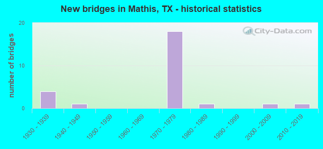
- New bridges - historical statistics
- 41930-1939
- 11940-1949
- 181970-1979
- 11980-1989
- 12000-2009
- 12010-2019

- Reconstructed bridges - Historical Statistics
- 21950-1959
- 01960-1969
- 01970-1979
- 01980-1989
- 21990-1999


- Bridge Condition - Deck
- 84.6%Good
- 15.4%Satisfactory

- Bridge Condition - Superstructure
- 7.7%Very good
- 61.5%Good
- 30.8%Satisfactory

- Bridge Condition - Substructure
- 61.5%Good
- 38.5%Satisfactory

- Bridge Condition - Channel
- 7.1%Very good
- 57.1%Good
- 28.6%Satisfactory
- 7.1%Fair

- Bridge Condition - Culverts
- 50.0%Good
- 50.0%Satisfactory
Find on map >> Show street view
Structure Number: 162050007403123, Location: 1.6 MI SE OF SH 359 (Lat: 28.091022, Lng: -97.809831), Route carried "on" structure: Interstate 37, Year Built: 1971, Status: Open, Structure Length: 7.32m (24.02ft), Average Daily Traffic: 12,288 (year 2019), Truck Traffic: 22%, Average Future Daily Traffic: 15,570 (year 2033), Design Load: HS 20, Features Intersected: SPUR 459
Minimum Vertical Clearance: 30+ m (98+ ft), Kilometerpoint: 0.713, Lanes on structure: 2, Lanes under structure: 4, Base Highway Network: Yes, Owner: State Highway Agency, Approaching Roadway Width: 11.6m (38.1ft), Material/Design: Prestressed concrete, Design/Construction: Stringer/Multi-beam, Number Of Spans In Main Unit: 4, Length of Maximum Span: 18.3m (60.0ft), Curb-To-Curb Width: 13.0m (42.7ft), Out-to-Out Width: 13.5m (44.3ft)
Condition: Deck: Good, Superstructure: Satisfactory, Substructure: Good, Operating Rating: 66.2 metric tons, Method Used To Determine Operating Rating: Load Factor (LF), Inventory Rating: 32.7 metric tons, Method Used To Determine Inventory Rating: Load Factor (LF), Structural Evaluation: Equal to present minimum criteria, Deck Geometry: Superior to present desirable criteria, Underclear: Equal to present minimum criteria, Approach Roadway Alignment: Equal to present desirable criteria, Designated Inspection Frequency: Every 24 months, Inspection Date: April 2020, Deck Structure Type: Concrete Cast-file-Place, Wearing Surface/Protective System: Wearing Surface: Bituminous
Find on map >> Show street view
Structure Number: 162050007403124, Location: 1.6 MI SE OF SH 359 (Lat: 28.091069, Lng: -97.809631), Route carried "on" structure: Interstate 37, Year Built: 1971, Status: Open, Structure Length: 7.32m (24.02ft), Average Daily Traffic: 10,694 (year 2019), Truck Traffic: 22%, Average Future Daily Traffic: 15,570 (year 2033), Design Load: HS 20, Features Intersected: SPUR 459
Minimum Vertical Clearance: 30+ m (98+ ft), Kilometerpoint: 0.713, Lanes on structure: 2, Lanes under structure: 4, Base Highway Network: Yes, Owner: State Highway Agency, Approaching Roadway Width: 11.6m (38.1ft), Material/Design: Prestressed concrete, Design/Construction: Stringer/Multi-beam, Number Of Spans In Main Unit: 4, Length of Maximum Span: 18.3m (60.0ft), Curb-To-Curb Width: 13.0m (42.7ft), Out-to-Out Width: 13.5m (44.3ft)
Condition: Deck: Good, Superstructure: Satisfactory, Substructure: Good, Operating Rating: 66.2 metric tons, Method Used To Determine Operating Rating: Load Factor (LF), Inventory Rating: 32.7 metric tons, Method Used To Determine Inventory Rating: Load Factor (LF), Structural Evaluation: Equal to present minimum criteria, Deck Geometry: Superior to present desirable criteria, Underclear: Equal to present minimum criteria, Approach Roadway Alignment: Equal to present desirable criteria, Designated Inspection Frequency: Every 24 months, Inspection Date: April 2020, Deck Structure Type: Concrete Cast-file-Place, Wearing Surface/Protective System: Wearing Surface: Bituminous
Find on map >> Show street view
Structure Number: 162050007403125, Location: 0.4 MI SE OF SH 359 (Lat: 28.108544, Lng: -97.814753), Route carried "on" structure: Interstate 37, Year Built: 1971, Status: Open, Structure Length: 5.49m (18.01ft), Average Daily Traffic: 12,288 (year 2019), Truck Traffic: 20%, Average Future Daily Traffic: 12,030 (year 2033), Design Load: HS 20, Features Intersected: ABANDONED RR
Minimum Vertical Clearance: 30+ m (98+ ft), Kilometerpoint: 2.747, Lanes on structure: 2, Base Highway Network: Yes, Owner: State Highway Agency, Approaching Roadway Width: 11.6m (38.1ft), Skew: 1 degrees, Material/Design: Prestressed concrete, Design/Construction: Stringer/Multi-beam, Number Of Spans In Main Unit: 3, Length of Maximum Span: 18.3m (60.0ft), Curb-To-Curb Width: 14.9m (48.9ft), Out-to-Out Width: 15.3m (50.2ft)
Condition: Deck: Good, Superstructure: Good, Substructure: Satisfactory, Operating Rating: 64.4 metric tons, Method Used To Determine Operating Rating: Load Factor (LF), Inventory Rating: 33.6 metric tons, Method Used To Determine Inventory Rating: Load Factor (LF), Structural Evaluation: Equal to present minimum criteria, Deck Geometry: Superior to present desirable criteria, Approach Roadway Alignment: Equal to present desirable criteria, Designated Inspection Frequency: Every 24 months, Inspection Date: April 2020, Deck Structure Type: Concrete Cast-file-Place, Wearing Surface/Protective System: Wearing Surface: Bituminous
Find on map >> Show street view
Structure Number: 162050007403126, Location: 0.4 MI SE OF SH 359 (Lat: 28.108636, Lng: -97.814575), Route carried "on" structure: Interstate 37, Year Built: 1971, Status: Open, Structure Length: 5.49m (18.01ft), Average Daily Traffic: 10,694 (year 2019), Truck Traffic: 20%, Average Future Daily Traffic: 12,030 (year 2033), Design Load: HS 20, Features Intersected: ABANDONED RR
Minimum Vertical Clearance: 30+ m (98+ ft), Kilometerpoint: 2.747, Lanes on structure: 2, Base Highway Network: Yes, Owner: State Highway Agency, Approaching Roadway Width: 11.6m (38.1ft), Skew: 1 degrees, Material/Design: Prestressed concrete, Design/Construction: Stringer/Multi-beam, Number Of Spans In Main Unit: 3, Length of Maximum Span: 18.3m (60.0ft), Curb-To-Curb Width: 13.0m (42.7ft), Out-to-Out Width: 13.5m (44.3ft)
Condition: Deck: Good, Superstructure: Good, Substructure: Satisfactory, Operating Rating: 68.0 metric tons, Method Used To Determine Operating Rating: Load Factor (LF), Inventory Rating: 38.1 metric tons, Method Used To Determine Inventory Rating: Load Factor (LF), Structural Evaluation: Equal to present minimum criteria, Deck Geometry: Superior to present desirable criteria, Approach Roadway Alignment: Equal to present desirable criteria, Designated Inspection Frequency: Every 24 months, Inspection Date: April 2020, Deck Structure Type: Concrete Cast-file-Place, Wearing Surface/Protective System: Wearing Surface: Bituminous
Find on map >> Show street view
Structure Number: 162050007403127, Location: 1.8 MI SE OF FM 3377 (Lat: 28.112956, Lng: -97.818197), Route carried "on" structure: Interstate 37, Year Built: 1971, Status: Open, Structure Length: 9.14m (29.99ft), Average Daily Traffic: 11,250 (year 2019), Truck Traffic: 20%, Average Future Daily Traffic: 12,030 (year 2033), Design Load: HS 20, Features Intersected: SH 359
Minimum Vertical Clearance: 30+ m (98+ ft), Kilometerpoint: 3.320, Lanes on structure: 2, Lanes under structure: 5, Base Highway Network: Yes, Owner: State Highway Agency, Approaching Roadway Width: 11.6m (38.1ft), Material/Design: Prestressed concrete, Design/Construction: Stringer/Multi-beam, Number Of Spans In Main Unit: 2, Number Of Approach Spans: 2, Length of Maximum Span: 27.4m (89.9ft), Curb-To-Curb Width: 13.0m (42.7ft), Out-to-Out Width: 13.5m (44.3ft)
Condition: Deck: Good, Superstructure: Good, Substructure: Good, Operating Rating: 67.1 metric tons, Method Used To Determine Operating Rating: Load Factor (LF), Inventory Rating: 34.5 metric tons, Method Used To Determine Inventory Rating: Load Factor (LF), Structural Evaluation: Better than present minimum criteria, Deck Geometry: Superior to present desirable criteria, Underclear: Superior to present desirable criteria, Approach Roadway Alignment: Equal to present desirable criteria, Designated Inspection Frequency: Every 24 months, Inspection Date: April 2020, Deck Structure Type: Concrete Cast-file-Place, Wearing Surface/Protective System: Wearing Surface: Bituminous
Find on map >> Show street view
Structure Number: 162050007403128, Location: 1.8 MI SE OF FM 3377 (Lat: 28.113058, Lng: -97.818031), Route carried "on" structure: Interstate 37, Year Built: 1971, Status: Open, Structure Length: 9.14m (29.99ft), Average Daily Traffic: 9,590 (year 2019), Truck Traffic: 20%, Average Future Daily Traffic: 12,030 (year 2033), Design Load: HS 20, Features Intersected: SH 359
Minimum Vertical Clearance: 30+ m (98+ ft), Kilometerpoint: 3.320, Lanes on structure: 2, Lanes under structure: 4, Base Highway Network: Yes, Owner: State Highway Agency, Approaching Roadway Width: 11.6m (38.1ft), Material/Design: Prestressed concrete, Design/Construction: Stringer/Multi-beam, Number Of Spans In Main Unit: 2, Number Of Approach Spans: 2, Length of Maximum Span: 27.4m (89.9ft), Curb-To-Curb Width: 13.0m (42.7ft), Out-to-Out Width: 13.5m (44.3ft)
Condition: Deck: Good, Superstructure: Good, Substructure: Good, Operating Rating: 64.4 metric tons, Method Used To Determine Operating Rating: Load Factor (LF), Inventory Rating: 31.7 metric tons, Method Used To Determine Inventory Rating: Load Factor (LF), Structural Evaluation: Better than present minimum criteria, Deck Geometry: Superior to present desirable criteria, Underclear: Equal to present desirable criteria, Approach Roadway Alignment: Equal to present desirable criteria, Designated Inspection Frequency: Every 24 months, Inspection Date: April 2020, Deck Structure Type: Concrete Cast-file-Place, Wearing Surface/Protective System: Wearing Surface: Bituminous
Find on map >> Show street view
Structure Number: 162050007403129, Location: 1.3 MI NW OF SH 359 (Lat: 28.128622, Lng: -97.830353), Route carried "on" structure: Interstate 37, Year Built: 1971, Status: Open, Structure Length: 0.79m (2.59ft), Average Daily Traffic: 17,922 (year 2020), Truck Traffic: 20%, Average Future Daily Traffic: 21,820 (year 2033), Features Intersected: DRAW
Minimum Vertical Clearance: 30+ m (98+ ft), Kilometerpoint: 5.489, Lanes on structure: 6, Base Highway Network: Yes, Owner: State Highway Agency, Approaching Roadway Width: 30.5m (100.1ft), Skew: 20 degrees, Material/Design: Concrete, Design/Construction: Culvert, Number Of Spans In Main Unit: 4, Length of Maximum Span: 1.8m (5.9ft)
Condition: Channel: Good, Culverts: Satisfactory, Operating Rating: 32.7 metric tons, Method Used To Determine Operating Rating: Field evaluation and documented engineering judgment, Inventory Rating: 24.5 metric tons, Method Used To Determine Inventory Rating: Field evaluation and documented engineering judgment, Structural Evaluation: Equal to present minimum criteria, Waterway Adequacy: Equal to present minimum criteria, Approach Roadway Alignment: Equal to present desirable criteria, Designated Inspection Frequency: Every 24 months, Inspection Date: March 2020
Find on map >> Show street view
Structure Number: 162050007403135, Location: 1.4 MI S OF SH 359 (Lat: 28.094150, Lng: -97.810506), Route carried "on" structure: Interstate 37, Year Built: 1971, Status: Open, Structure Length: 0.85m (2.79ft), Average Daily Traffic: 19,764 (year 2020), Truck Traffic: 20%, Average Future Daily Traffic: 24,060 (year 2033), Features Intersected: DRAINAGE DITCH
Minimum Vertical Clearance: 30+ m (98+ ft), Kilometerpoint: 1.090, Lanes on structure: 8, Base Highway Network: Yes, Owner: State Highway Agency, Approaching Roadway Width: 40.8m (133.9ft), Skew: 21 degrees, Material/Design: Concrete, Design/Construction: Culvert, Number Of Spans In Main Unit: 5, Length of Maximum Span: 1.5m (4.9ft)
Condition: Channel: Good, Culverts: Good, Operating Rating: 32.7 metric tons, Method Used To Determine Operating Rating: Field evaluation and documented engineering judgment, Inventory Rating: 24.5 metric tons, Method Used To Determine Inventory Rating: Field evaluation and documented engineering judgment, Structural Evaluation: Equal to present minimum criteria, Waterway Adequacy: Equal to present minimum criteria, Approach Roadway Alignment: Equal to present desirable criteria, Designated Inspection Frequency: Every 24 months, Inspection Date: March 2020
Find on map >> Show street view
Structure Number: 162050007404009, Location: 0.5 MI SE OF SH 188 (Lat: 28.050075, Lng: -97.763786), Route carried "on" structure: ServiceInterstate 37, Year Built: 1934, Year Reconstructed: 1956, Status: Open, Structure Length: 4.42m (14.50ft), Average Daily Traffic: 570 (year 2013), Truck Traffic: 23%, Average Future Daily Traffic: 790 (year 2033), Design Load: H 15, Features Intersected: ARROYO NOMBRE DE DIOS
Minimum Vertical Clearance: 30+ m (98+ ft), Kilometerpoint: 22.476, Lanes on structure: 2, Owner: State Highway Agency, Approaching Roadway Width: 9.1m (29.9ft), Material/Design: Concrete, Design/Construction: Tee Beam, Number Of Spans In Main Unit: 5, Length of Maximum Span: 8.8m (28.9ft), Curb-To-Curb Width: 11.5m (37.7ft), Out-to-Out Width: 12.8m (42.0ft)
Condition: Deck: Good, Superstructure: Good, Substructure: Good, Channel: Satisfactory, Operating Rating: 59.0 metric tons, Method Used To Determine Operating Rating: Load Factor (LF), Inventory Rating: 35.4 metric tons, Method Used To Determine Inventory Rating: Load Factor (LF), Structural Evaluation: Better than present minimum criteria, Deck Geometry: Better than present minimum criteria, Waterway Adequacy: Better than present minimum criteria, Approach Roadway Alignment: Equal to present desirable criteria, Designated Inspection Frequency: Every 24 months, Inspection Date: March 2020, Deck Structure Type: Concrete Cast-file-Place, Wearing Surface/Protective System: Wearing Surface: Bituminous
Find on map >> Show street view
Structure Number: 162050007404118, Location: 0.5 MI SE OF SH 188 (Lat: 28.049625, Lng: -97.764231), Route carried "on" structure: Interstate 37, Year Built: 1970, Status: Open, Structure Length: 4.75m (15.58ft), Average Daily Traffic: 12,004 (year 2019), Truck Traffic: 20%, Average Future Daily Traffic: 15,960 (year 2033), Design Load: HS 20, Features Intersected: ARROYO NOMBRE DE DIOS
Minimum Vertical Clearance: 30+ m (98+ ft), Kilometerpoint: 22.412, Lanes on structure: 2, Owner: State Highway Agency, Approaching Roadway Width: 11.6m (38.1ft), Skew: 1 degrees, Material/Design: Concrete, Design/Construction: Stringer/Multi-beam, Number Of Spans In Main Unit: 5, Length of Maximum Span: 9.4m (30.8ft), Curb-To-Curb Width: 13.0m (42.7ft), Out-to-Out Width: 13.5m (44.3ft)
Condition: Deck: Good, Superstructure: Good, Substructure: Satisfactory, Channel: Good, Operating Rating: 68.0 metric tons, Method Used To Determine Operating Rating: Load Factor (LF), Inventory Rating: 40.8 metric tons, Method Used To Determine Inventory Rating: Load Factor (LF), Structural Evaluation: Equal to present minimum criteria, Deck Geometry: Superior to present desirable criteria, Waterway Adequacy: Superior to present desirable criteria, Approach Roadway Alignment: Equal to present desirable criteria, Length Of Structure Improvement: 4.75m (15.58ft), Designated Inspection Frequency: Every 24 months, Inspection Date: April 2020, Bridge Improvement Cost: $13,000, Roadway Improvement Cost: $3,000, Total Project Cost: $16,000, Deck Structure Type: Concrete Cast-file-Place, Wearing Surface/Protective System: Wearing Surface: Bituminous
Find on map >> Show street view
Structure Number: 162050007404119, Location: 0.5 MI SE OF SH 188 (Lat: 28.049564, Lng: -97.764289), Route carried "on" structure: Interstate 37, Year Built: 1970, Status: Open, Structure Length: 5.03m (16.50ft), Average Daily Traffic: 13,737 (year 2019), Truck Traffic: 20%, Average Future Daily Traffic: 15,960 (year 2033), Design Load: HS 20, Features Intersected: ARROYO NOMBRE DE DIOS
Minimum Vertical Clearance: 30+ m (98+ ft), Kilometerpoint: 22.421, Lanes on structure: 2, Owner: State Highway Agency, Approaching Roadway Width: 11.6m (38.1ft), Skew: 3 degrees, Material/Design: Concrete, Design/Construction: Stringer/Multi-beam, Number Of Spans In Main Unit: 5, Length of Maximum Span: 10.1m (33.1ft), Curb-To-Curb Width: 13.0m (42.7ft), Out-to-Out Width: 13.5m (44.3ft)
Condition: Deck: Satisfactory, Superstructure: Satisfactory, Substructure: Satisfactory, Channel: Good, Operating Rating: 68.0 metric tons, Method Used To Determine Operating Rating: Load Factor (LF), Inventory Rating: 40.8 metric tons, Method Used To Determine Inventory Rating: Load Factor (LF), Structural Evaluation: Equal to present minimum criteria, Deck Geometry: Superior to present desirable criteria, Waterway Adequacy: Superior to present desirable criteria, Approach Roadway Alignment: Equal to present desirable criteria, Designated Inspection Frequency: Every 24 months, Inspection Date: April 2020, Deck Structure Type: Concrete Cast-file-Place, Wearing Surface/Protective System: Wearing Surface: Bituminous
Find on map >> Show street view
Structure Number: 16205000740412, Location: 0.5 MI S OF SH 188 (Lat: 28.049075, Lng: -97.764717), Route carried "on" structure: ServiceInterstate 37, Year Built: 1970, Status: Open, Structure Length: 4.18m (13.71ft), Average Daily Traffic: 570 (year 2013), Truck Traffic: 23%, Average Future Daily Traffic: 790 (year 2033), Design Load: H 20, Features Intersected: ARROYO NOMBRE DE DIOS
Minimum Vertical Clearance: 30+ m (98+ ft), Kilometerpoint: 22.412, Lanes on structure: 2, Owner: State Highway Agency, Approaching Roadway Width: 6.7m (22.0ft), Skew: 4 degrees, Material/Design: Concrete, Design/Construction: Stringer/Multi-beam, Number Of Spans In Main Unit: 4, Length of Maximum Span: 10.4m (34.1ft), Curb-To-Curb Width: 10.3m (33.8ft), Out-to-Out Width: 11.1m (36.4ft)
Condition: Deck: Satisfactory, Superstructure: Satisfactory, Substructure: Satisfactory, Channel: Satisfactory, Operating Rating: 68.0 metric tons, Method Used To Determine Operating Rating: Load Factor (LF), Inventory Rating: 40.8 metric tons, Method Used To Determine Inventory Rating: Load Factor (LF), Structural Evaluation: Equal to present minimum criteria, Deck Geometry: Equal to present minimum criteria, Waterway Adequacy: Equal to present minimum criteria, Approach Roadway Alignment: Equal to present desirable criteria, Designated Inspection Frequency: Every 24 months, Inspection Date: April 2020, Deck Structure Type: Concrete Cast-file-Place
Find on map >> Show street view
Structure Number: 162050007404121, Location: 2.6 MI NW OF FM 630 (Lat: 28.054319, Lng: -97.771625), Route carried "on" structure: State highway 188, Year Built: 1970, Status: Open, Structure Length: 10.15m (33.30ft), Average Daily Traffic: 1,370 (year 2013), Truck Traffic: 10%, Average Future Daily Traffic: 1,930 (year 2033), Design Load: H 20, Features Intersected: IH 37
Minimum Vertical Clearance: 30+ m (98+ ft), Kilometerpoint: 0.032, Lanes on structure: 2, Lanes under structure: 4, Owner: State Highway Agency, Approaching Roadway Width: 7.3m (24.0ft), Skew: 3 degrees, Material/Design: Prestressed concrete, Design/Construction: Stringer/Multi-beam, Number Of Spans In Main Unit: 2, Number Of Approach Spans: 2, Length of Maximum Span: 31.7m (104.0ft), Curb-To-Curb Width: 13.4m (44.0ft), Out-to-Out Width: 14.1m (46.3ft)
Condition: Deck: Good, Superstructure: Good, Substructure: Good, Operating Rating: 68.0 metric tons, Method Used To Determine Operating Rating: Load Factor (LF), Inventory Rating: 29.9 metric tons, Method Used To Determine Inventory Rating: Load Factor (LF), Structural Evaluation: Better than present minimum criteria, Deck Geometry: Equal to present desirable criteria, Underclear: Better than present minimum criteria, Approach Roadway Alignment: Equal to present desirable criteria, Designated Inspection Frequency: Every 24 months, Inspection Date: April 2020, Deck Structure Type: Concrete Cast-file-Place
Find on map >> Show street view
Structure Number: 162050008703015, Location: 1.35 MI SW OF FM 666 (Lat: 28.074217, Lng: -97.835786), Route carried "on" structure: State highway 359, Year Built: 1932, Year Reconstructed: 1955, Status: Open, Structure Length: 1.49m (4.89ft), Average Daily Traffic: 4,806 (year 2020), Truck Traffic: 23%, Average Future Daily Traffic: 6,100 (year 2033), Design Load: H 15, Features Intersected: SIXMILE CREEK
Minimum Vertical Clearance: 30+ m (98+ ft), Kilometerpoint: 5.102, Lanes on structure: 2, Owner: State Highway Agency, Approaching Roadway Width: 11.0m (36.1ft), Material/Design: Concrete, Design/Construction: Culvert, Number Of Spans In Main Unit: 7, Length of Maximum Span: 1.8m (5.9ft), Curb-To-Curb Width: 13.4m (44.0ft), Out-to-Out Width: 13.8m (45.3ft)
Condition: Channel: Good, Culverts: Satisfactory, Operating Rating: 39.9 metric tons, Method Used To Determine Operating Rating: Load Factor (LF), Inventory Rating: 23.6 metric tons, Method Used To Determine Inventory Rating: Load Factor (LF), Structural Evaluation: Equal to present minimum criteria, Deck Geometry: Better than present minimum criteria, Waterway Adequacy: Equal to present minimum criteria, Approach Roadway Alignment: Equal to present desirable criteria, Designated Inspection Frequency: Every 24 months, Inspection Date: April 2020, Deck Structure Type: Concrete Cast-file-Place, Wearing Surface/Protective System: Wearing Surface: Bituminous
Find on map >> Show street view
Structure Number: 162050008704016, Location: 2.1 MI NE OF IH 37 (Lat: 28.132736, Lng: -97.792186), Route carried "on" structure: State highway 359, Year Built: 1931, Year Reconstructed: 1990, Status: Open, Structure Length: 2.38m (7.81ft), Average Daily Traffic: 5,308 (year 2020), Truck Traffic: 21%, Average Future Daily Traffic: 6,720 (year 2033), Design Load: H 15, Features Intersected: ARROYO NOMBRE DE DIOS
Minimum Vertical Clearance: 30+ m (98+ ft), Kilometerpoint: 6.309, Lanes on structure: 2, Base Highway Network: Yes, Owner: State Highway Agency, Approaching Roadway Width: 13.4m (44.0ft), Material/Design: Concrete, Design/Construction: Culvert, Number Of Spans In Main Unit: 7, Length of Maximum Span: 3.0m (9.8ft), Curb-To-Curb Width: 13.4m (44.0ft), Out-to-Out Width: 15.2m (49.9ft)
Condition: Channel: Satisfactory, Culverts: Satisfactory, Operating Rating: 39.9 metric tons, Method Used To Determine Operating Rating: Load Factor (LF), Inventory Rating: 23.6 metric tons, Method Used To Determine Inventory Rating: Load Factor (LF), Structural Evaluation: Somewhat better than minimum adequacy, Deck Geometry: Equal to present minimum criteria, Waterway Adequacy: Equal to present minimum criteria, Approach Roadway Alignment: Equal to present desirable criteria, Designated Inspection Frequency: Every 24 months, Inspection Date: April 2020, Deck Structure Type: Concrete Cast-file-Place, Wearing Surface/Protective System: Wearing Surface: Bituminous
Find on map >> Show street view
Structure Number: 162050008704023, Location: 0.15 MI NE OF IH 37 (Lat: 28.113919, Lng: -97.815278), Route carried "on" structure: State highway 359, Year Built: 1937, Year Reconstructed: 1990, Status: Open, Structure Length: 1.04m (3.41ft), Average Daily Traffic: 5,308 (year 2020), Truck Traffic: 21%, Average Future Daily Traffic: 6,720 (year 2033), Design Load: H 15, Features Intersected: DRAINAGE DITCH
Minimum Vertical Clearance: 30+ m (98+ ft), Kilometerpoint: 3.119, Lanes on structure: 4, Base Highway Network: Yes, Owner: State Highway Agency, Approaching Roadway Width: 23.2m (76.1ft), Skew: 20 degrees, Material/Design: Concrete, Design/Construction: Culvert, Number Of Spans In Main Unit: 6, Length of Maximum Span: 1.5m (4.9ft)
Condition: Channel: Good, Culverts: Good, Operating Rating: 39.9 metric tons, Method Used To Determine Operating Rating: Load Factor (LF), Inventory Rating: 23.6 metric tons, Method Used To Determine Inventory Rating: Load Factor (LF), Structural Evaluation: Somewhat better than minimum adequacy, Waterway Adequacy: Equal to present minimum criteria, Approach Roadway Alignment: Equal to present desirable criteria, Designated Inspection Frequency: Every 24 months, Inspection Date: April 2020
Find on map >> Show street view
Structure Number: 162050105203038, Location: 3.8 MI SE OF SH 359 (Lat: 28.043744, Lng: -97.789111), Route carried "on" structure: State highway 666, Year Built: 1980, Status: Open, Structure Length: 4.63m (15.19ft), Average Daily Traffic: 1,419 (year 2020), Truck Traffic: 13%, Average Future Daily Traffic: 1,340 (year 2033), Design Load: HS 20, Features Intersected: ARROYO NOMBRE DE DIOS
Minimum Vertical Clearance: 30+ m (98+ ft), Kilometerpoint: 6.087, Lanes on structure: 2, Owner: State Highway Agency, Approaching Roadway Width: 13.4m (44.0ft), Material/Design: Concrete, Design/Construction: Stringer/Multi-beam, Number Of Spans In Main Unit: 5, Length of Maximum Span: 9.1m (29.9ft), Curb-To-Curb Width: 12.2m (40.0ft), Out-to-Out Width: 12.9m (42.3ft)
Condition: Deck: Good, Superstructure: Good, Substructure: Good, Channel: Fair, Operating Rating: 50.8 metric tons, Method Used To Determine Operating Rating: Load Factor (LF), Inventory Rating: 37.2 metric tons, Method Used To Determine Inventory Rating: Load Factor (LF), Structural Evaluation: Better than present minimum criteria, Deck Geometry: Better than present minimum criteria, Waterway Adequacy: Superior to present desirable criteria, Approach Roadway Alignment: Equal to present desirable criteria, Designated Inspection Frequency: Every 24 months, Inspection Date: April 2020, Deck Structure Type: Concrete Cast-file-Place, Wearing Surface/Protective System: Wearing Surface: Bituminous
Find on map >> Show street view
Structure Number: 162050120801122, Location: 0.3 MI E OF IH 37 (Lat: 28.055906, Lng: -97.766450), Route carried "on" structure: State highway 188, Year Built: 2011, Status: Open, Structure Length: 14.63m (48.00ft), Average Daily Traffic: 2,950 (year 2020), Truck Traffic: 13%, Average Future Daily Traffic: 2,700 (year 2034), Design Load: HL 93, Features Intersected: BAYOU CREEK
Minimum Vertical Clearance: 30+ m (98+ ft), Kilometerpoint: 0.565, Lanes on structure: 2, Owner: State Highway Agency, Approaching Roadway Width: 13.4m (44.0ft), Skew: 9 degrees, Material/Design: Prestressed concrete, Design/Construction: Stringer/Multi-beam, Number Of Spans In Main Unit: 6, Length of Maximum Span: 24.4m (80.1ft), Curb-To-Curb Width: 13.2m (43.3ft), Out-to-Out Width: 14.0m (45.9ft)
Condition: Deck: Good, Superstructure: Very good, Substructure: Good, Channel: Very good, Operating Rating: 54.4 metric tons, Method Used To Determine Operating Rating: Assigned ratings based on Load and Resistance Factor Design (LRFD) reported in metric tons, Inventory Rating: 32.7 metric tons, Method Used To Determine Inventory Rating: Assigned ratings based on Load and Resistance Factor Design (LRFD) reported in metric tons, Structural Evaluation: Better than present minimum criteria, Deck Geometry: Equal to present minimum criteria, Waterway Adequacy: Superior to present desirable criteria, Approach Roadway Alignment: Equal to present desirable criteria, Designated Inspection Frequency: Every 24 months, Inspection Date: April 2020, Deck Structure Type: Concrete Precast Panels
Find on map >> Show street view
Structure Number: 162050252101002, Location: 0.75 MI SW OF SAN PAT AVE (Lat: 28.086519, Lng: -97.836336), Route carried "on" structure: State highway 1068, Year Built: 2008, Status: Open, Structure Length: 1.13m (3.71ft), Average Daily Traffic: 1,624 (year 2020), Truck Traffic: 10%, Average Future Daily Traffic: 3,000 (year 2034), Features Intersected: DRAW
Minimum Vertical Clearance: 30+ m (98+ ft), Kilometerpoint: 1.207, Lanes on structure: 2, Owner: State Highway Agency, Approaching Roadway Width: 7.3m (24.0ft), Skew: 1 degrees, Material/Design: Concrete, Design/Construction: Culvert, Number Of Spans In Main Unit: 3, Length of Maximum Span: 3.0m (9.8ft), Curb-To-Curb Width: 9.8m (32.2ft), Out-to-Out Width: 10.5m (34.4ft)
Condition: Channel: Good, Culverts: Good, Operating Rating: 32.7 metric tons, Method Used To Determine Operating Rating: No rating analysis performed, Inventory Rating: 24.5 metric tons, Method Used To Determine Inventory Rating: No rating analysis performed, Structural Evaluation: Equal to present minimum criteria, Deck Geometry: Somewhat better than minimum adequacy, Waterway Adequacy: Equal to present minimum criteria, Approach Roadway Alignment: Better than present minimum criteria, Designated Inspection Frequency: Every 24 months, Inspection Date: April 2020, Deck Structure Type: Concrete Precast Panels, Wearing Surface/Protective System: Wearing Surface: Bituminous
Find on map >> Show street view
Structure Number: 162050AA0168001, Location: 1.40 MI SE OF SH 359 (Lat: 28.111078, Lng: -97.782761), Route carried "on" structure: County highway 556, Year Built: 1948, Status: Open, Structure Length: 0.91m (2.99ft), Average Daily Traffic: 320 (year 2015), Truck Traffic: 1%, Average Future Daily Traffic: 400 (year 2035), Features Intersected: ARROYO NOMBRE DE DIOS
Minimum Vertical Clearance: 30+ m (98+ ft), Kilometerpoint: 2.173, Lanes on structure: 2, Owner: County Highway Agency, Approaching Roadway Width: 6.1m (20.0ft), Skew: 4 degrees, Material/Design: Concrete, Design/Construction: Culvert, Number Of Spans In Main Unit: 3, Length of Maximum Span: 2.7m (8.9ft), Curb-To-Curb Width: 6.2m (20.3ft), Out-to-Out Width: 6.6m (21.7ft)
Condition: Channel: Satisfactory, Culverts: Satisfactory, Operating Rating: 32.7 metric tons, Method Used To Determine Operating Rating: Field evaluation and documented engineering judgment, Inventory Rating: 24.5 metric tons, Method Used To Determine Inventory Rating: Field evaluation and documented engineering judgment, Structural Evaluation: Equal to present minimum criteria, Deck Geometry: Meets minimum limits, Waterway Adequacy: Better than present minimum criteria, Approach Roadway Alignment: Equal to present desirable criteria, Designated Inspection Frequency: Every 24 months, Inspection Date: June 2021, Deck Structure Type: Concrete Cast-file-Place
Find on map >> Show street view
Structure Number: 162050C00080001, Location: 0.25 MI NW OF SH 359 BUS (Lat: 28.096947, Lng: -97.831781), Route carried "on" structure: City street 511, Year Built: 1977, Status: Open, Structure Length: 0.98m (3.22ft), Average Daily Traffic: 890 (year 2015), Average Future Daily Traffic: 1,000 (year 2035), Features Intersected: DRAIN, Facility Carried by Structure: W SAN PATRICIO AVE
Minimum Vertical Clearance: 30+ m (98+ ft), Kilometerpoint: 0.402, Lanes on structure: 2, Owner: City or Municipal Highway Agency, Approaching Roadway Width: 9.1m (29.9ft), Skew: 4 degrees, Material/Design: Concrete, Design/Construction: Culvert, Number Of Spans In Main Unit: 4, Length of Maximum Span: 1.5m (4.9ft), Curb-To-Curb Width: 11.0m (36.1ft), Out-to-Out Width: 17.7m (58.1ft)
Condition: Channel: Good, Culverts: Good, Operating Rating: 32.7 metric tons, Method Used To Determine Operating Rating: Field evaluation and documented engineering judgment, Inventory Rating: 24.5 metric tons, Method Used To Determine Inventory Rating: Field evaluation and documented engineering judgment, Structural Evaluation: Equal to present minimum criteria, Deck Geometry: Better than present minimum criteria, Waterway Adequacy: Equal to present minimum criteria, Approach Roadway Alignment: Equal to present desirable criteria, Designated Inspection Frequency: Every 24 months, Inspection Date: June 2021, Deck Structure Type: Concrete Cast-file-Place, Wearing Surface/Protective System: Wearing Surface: Bituminous
Find on map >> Show street view
Structure Number: 162050007403123, Location: 1.6 MI SE OF SH 359 (Lat: 28.091022, Lng: -97.809831), Route carried "under" structure: Spur State highway 459, Year Built: 1971, Structure Length: 0. m, Average Daily Traffic: 4,800 (year 2013), Truck Traffic: 11%, Features Intersected: SPUR 459, Facility Carried by Structure: IH 37 SB
Minimum Vertical Clearance: 4.88m (16.01ft), Kilometerpoint: 17.576, Lanes on structure: 2, Lanes under structure: 4, Material/Design: Prestressed concrete, Design/Construction: Stringer/Multi-beam, Length of Maximum Span: 18.3m (60.0ft)
Find on map >> Show street view
Structure Number: 162050007403124, Location: 1.6 MI SE OF SH 359 (Lat: 28.091069, Lng: -97.809631), Route carried "under" structure: Spur State highway 459, Year Built: 1971, Structure Length: 0. m, Average Daily Traffic: 4,800 (year 2013), Truck Traffic: 11%, Features Intersected: SPUR 459, Facility Carried by Structure: IH 37 NB
Minimum Vertical Clearance: 4.78m (15.68ft), Kilometerpoint: 17.590, Lanes on structure: 2, Lanes under structure: 4, Material/Design: Prestressed concrete, Design/Construction: Stringer/Multi-beam, Length of Maximum Span: 18.3m (60.0ft)
Find on map >> Show street view
Structure Number: 162050007403127, Location: 1.8 MI SE OF FM 3377 (Lat: 28.112956, Lng: -97.818197), Route carried "under" structure: State highway 359, Year Built: 1971, Structure Length: 0. m, Average Daily Traffic: 4,800 (year 2013), Truck Traffic: 21%, Features Intersected: SH 359, Facility Carried by Structure: IH 37 SB
Minimum Vertical Clearance: 5.54m (18.18ft), Kilometerpoint: 2.882, Lanes on structure: 2, Lanes under structure: 5, Material/Design: Prestressed concrete, Design/Construction: Stringer/Multi-beam, Length of Maximum Span: 27.4m (89.9ft)
Find on map >> Show street view
Structure Number: 162050007403128, Location: 1.8 MI SE OF FM 3377 (Lat: 28.113058, Lng: -97.818031), Route carried "under" structure: State highway 359, Year Built: 1971, Structure Length: 0. m, Average Daily Traffic: 4,800 (year 2013), Truck Traffic: 21%, Features Intersected: SH 359, Facility Carried by Structure: IH 37 NB
Minimum Vertical Clearance: 5.87m (19.26ft), Kilometerpoint: 2.915, Lanes on structure: 2, Lanes under structure: 4, Material/Design: Prestressed concrete, Design/Construction: Stringer/Multi-beam, Length of Maximum Span: 27.4m (89.9ft)
Find on map >> Show street view
Structure Number: 162050007404121, Location: 2.6 MI NW OF FM 630 (Lat: 28.054319, Lng: -97.771625), Route carried "under" structure: Interstate 37, Year Built: 1970, Structure Length: 0. m, Average Daily Traffic: 22,800 (year 2013), Truck Traffic: 20%, Features Intersected: IH 37, Facility Carried by Structure: SH 188
Minimum Vertical Clearance: 5.21m (17.09ft), Kilometerpoint: 23.323, Material/Design: Prestressed concrete, Design/Construction: Stringer/Multi-beam, Length of Maximum Span: 31.7m (104.0ft)