Bridge Statistics for Maurertown, Virginia (VA)
Condition, Traffic, Stress, Structural Evaluation, Project Costs
- National Bridge Inventory (NBI) Statistics
- 19Number of bridges
- 151ft / 46.2mTotal length
- $770,000Total costs
- 219,694Total average daily traffic
- 34,451Total average daily truck traffic
- National Bridge Inventory (NBI) Registered Bridges for Maurertown
- No street view available for this location
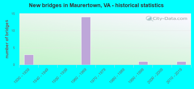
- New bridges - historical statistics
- 31930-1939
- 141960-1969
- 11990-1999
- 12010-2019

- Reconstructed bridges - Historical Statistics
- 11980-1989
- 01990-1999
- 02000-2009
- 02010-2019
- 12020-2022


- Bridge Condition - Deck
- 9.1%Excellent
- 27.3%Very good
- 18.2%Good
- 18.2%Satisfactory
- 27.3%Fair

- Bridge Condition - Superstructure
- 9.1%Excellent
- 18.2%Very good
- 18.2%Good
- 27.3%Satisfactory
- 27.3%Fair

- Bridge Condition - Substructure
- 18.2%Very good
- 9.1%Good
- 45.5%Satisfactory
- 27.3%Fair

- Bridge Condition - Channel
- 80.0%Very good
- 20.0%Good
Find on map >> Show street view
Structure Number: 16959, Location: 0.11 TO 740 - 0.13 TO 650 (Lat: 38.938894, Lng: -78.450489), Route carried "on" structure: US 11, Year Built: 1932, Status: Open, Structure Length: 0.82m (2.69ft), Average Daily Traffic: 6,550 (year 2020), Truck Traffic: 2%, Average Future Daily Traffic: 7,205 (year 2040), Design Load: HS 20, Features Intersected: JORDON RUN, Facility Carried by Structure: OLD VALLEY PK
Minimum Vertical Clearance: 30+ m (98+ ft), Kilometerpoint: 491.075, Lanes on structure: 3, Owner: State Highway Agency, Approaching Roadway Width: 9.8m (32.2ft), Skew: 4 degrees, Material/Design: Concrete, Design/Construction: Culvert, Number Of Spans In Main Unit: 3, Length of Maximum Span: 1.8m (5.9ft)
Condition: Channel: Good, Culverts: Satisfactory, Operating Rating: 89.8 metric tons, Method Used To Determine Operating Rating: Field evaluation and documented engineering judgment, Inventory Rating: 88.9 metric tons, Method Used To Determine Inventory Rating: Field evaluation and documented engineering judgment, Structural Evaluation: Equal to present minimum criteria, Waterway Adequacy: Equal to present minimum criteria, Approach Roadway Alignment: Equal to present minimum criteria, Length Of Structure Improvement: 0.91m (2.99ft), Designated Inspection Frequency: Every 24 months, Inspection Date: July 2021, Bridge Improvement Cost: $120,000, Roadway Improvement Cost: $40,000, Total Project Cost: $161,000
Find on map >> Show street view
Structure Number: 16999, Location: 4.42 TO 42 - 3.94 TO 651 (Lat: 38.926050, Lng: -78.484694), Route carried "on" structure: Interstate 81, Year Built: 1965, Status: Open, Structure Length: 3.41m (11.19ft), Average Daily Traffic: 18,608 (year 2020), Truck Traffic: 24%, Average Future Daily Traffic: 26,051 (year 2040), Design Load: HS 20+Mod, Features Intersected: SAUMSVILLE RD (RTE 600)
Minimum Vertical Clearance: 30+ m (98+ ft), Kilometerpoint: 464.020, Lanes on structure: 2, Lanes under structure: 2, Base Highway Network: Yes, Owner: State Highway Agency, Approaching Roadway Width: 11.3m (37.1ft), Material/Design: Concrete, Design/Construction: Tee Beam, Number Of Spans In Main Unit: 3, Length of Maximum Span: 11.3m (37.1ft), Curb-To-Curb Width: 12.8m (42.0ft), Out-to-Out Width: 13.4m (44.0ft)
Condition: Deck: Fair, Superstructure: Satisfactory, Substructure: Fair, Operating Rating: 67.1 metric tons, Method Used To Determine Operating Rating: Load and Resistance Factor (LRFR), Inventory Rating: 51.7 metric tons, Method Used To Determine Inventory Rating: Load and Resistance Factor (LRFR), Structural Evaluation: Somewhat better than minimum adequacy, Deck Geometry: Equal to present desirable criteria, Underclear: Meets minimum limits, Approach Roadway Alignment: Equal to present desirable criteria, Designated Inspection Frequency: Every 24 months, Inspection Date: Febuary 2021, Bridge Improvement Cost: $70,000, Roadway Improvement Cost: $1,000, Total Project Cost: $72,000, Deck Structure Type: Concrete Cast-file-Place, Wearing Surface/Protective System: Wearing Surface: Latex Concrete
Find on map >> Show street view
Structure Number: 17001, Location: 4.42 TO 42 - 3.94 TO 651 (Lat: 38.926225, Lng: -78.485025), Route carried "on" structure: Interstate 81, Year Built: 1965, Status: Open, Structure Length: 3.41m (11.19ft), Average Daily Traffic: 19,823 (year 2020), Truck Traffic: 24%, Average Future Daily Traffic: 27,752 (year 2040), Design Load: HS 20+Mod, Features Intersected: SAUMSVILLE RD (RT 600)
Minimum Vertical Clearance: 30+ m (98+ ft), Kilometerpoint: 464.454, Lanes on structure: 2, Lanes under structure: 2, Base Highway Network: Yes, Owner: State Highway Agency, Approaching Roadway Width: 11.3m (37.1ft), Material/Design: Concrete, Design/Construction: Tee Beam, Number Of Spans In Main Unit: 3, Length of Maximum Span: 11.3m (37.1ft), Curb-To-Curb Width: 12.8m (42.0ft), Out-to-Out Width: 13.4m (44.0ft)
Condition: Deck: Good, Superstructure: Fair, Substructure: Good, Operating Rating: 67.1 metric tons, Method Used To Determine Operating Rating: Load and Resistance Factor (LRFR), Inventory Rating: 51.7 metric tons, Method Used To Determine Inventory Rating: Load and Resistance Factor (LRFR), Structural Evaluation: Somewhat better than minimum adequacy, Deck Geometry: Equal to present desirable criteria, Underclear: Meets minimum limits, Approach Roadway Alignment: Equal to present desirable criteria, Designated Inspection Frequency: Every 24 months, Inspection Date: June 2020, Bridge Improvement Cost: $70,000, Roadway Improvement Cost: $1,000, Total Project Cost: $72,000, Deck Structure Type: Concrete Cast-file-Place, Wearing Surface/Protective System: Wearing Surface: Epoxy Overlay
Find on map >> Show street view
Structure Number: 17003, Location: 4.89 TO 42 - 3.25 TO 651 (Lat: 38.931236, Lng: -78.479178), Route carried "on" structure: Interstate 81, Year Built: 1965, Status: Open, Structure Length: 3.35m (10.99ft), Average Daily Traffic: 18,608 (year 2020), Truck Traffic: 24%, Average Future Daily Traffic: 26,051 (year 2040), Design Load: HS 20+Mod, Features Intersected: HARMAN RD
Minimum Vertical Clearance: 30+ m (98+ ft), Kilometerpoint: 464.776, Lanes on structure: 2, Lanes under structure: 2, Base Highway Network: Yes, Owner: State Highway Agency, Approaching Roadway Width: 11.3m (37.1ft), Material/Design: Concrete, Design/Construction: Tee Beam, Number Of Spans In Main Unit: 3, Length of Maximum Span: 11.6m (38.1ft), Curb-To-Curb Width: 12.8m (42.0ft), Out-to-Out Width: 13.4m (44.0ft)
Condition: Deck: Fair, Superstructure: Fair, Substructure: Fair, Operating Rating: 65.3 metric tons, Method Used To Determine Operating Rating: Load and Resistance Factor (LRFR), Inventory Rating: 50.8 metric tons, Method Used To Determine Inventory Rating: Load and Resistance Factor (LRFR), Structural Evaluation: Somewhat better than minimum adequacy, Deck Geometry: Equal to present desirable criteria, Underclear: Meets minimum limits, Approach Roadway Alignment: Equal to present desirable criteria, Designated Inspection Frequency: Every 24 months, Inspection Date: Febuary 2021, Bridge Improvement Cost: $43,000, Roadway Improvement Cost: $1,000, Total Project Cost: $45,000, Deck Structure Type: Concrete Cast-file-Place, Wearing Surface/Protective System: Wearing Surface: Latex Concrete
Find on map >> Show street view
Structure Number: 17005, Location: 4.89 TO 42 - 3.25 TO 651 (Lat: 38.931600, Lng: -78.479822), Route carried "on" structure: Interstate 81, Year Built: 1965, Status: Open, Structure Length: 3.35m (10.99ft), Average Daily Traffic: 19,823 (year 2020), Truck Traffic: 24%, Average Future Daily Traffic: 27,752 (year 2040), Design Load: HS 20+Mod, Features Intersected: HARMAN RD (RT 625)
Minimum Vertical Clearance: 30+ m (98+ ft), Kilometerpoint: 465.213, Lanes on structure: 2, Lanes under structure: 2, Base Highway Network: Yes, Owner: State Highway Agency, Approaching Roadway Width: 11.3m (37.1ft), Material/Design: Concrete, Design/Construction: Tee Beam, Number Of Spans In Main Unit: 3, Length of Maximum Span: 11.6m (38.1ft), Curb-To-Curb Width: 12.8m (42.0ft), Out-to-Out Width: 13.4m (44.0ft)
Condition: Deck: Fair, Superstructure: Fair, Substructure: Fair, Operating Rating: 65.3 metric tons, Method Used To Determine Operating Rating: Load and Resistance Factor (LRFR), Inventory Rating: 50.8 metric tons, Method Used To Determine Inventory Rating: Load and Resistance Factor (LRFR), Structural Evaluation: Somewhat better than minimum adequacy, Deck Geometry: Equal to present desirable criteria, Underclear: Meets minimum limits, Approach Roadway Alignment: Better than present minimum criteria, Designated Inspection Frequency: Every 24 months, Inspection Date: May 2021, Bridge Improvement Cost: $43,000, Total Project Cost: $45,000, Deck Structure Type: Concrete Cast-file-Place, Wearing Surface/Protective System: Wearing Surface: Latex Concrete
Find on map >> Show street view
Structure Number: 17125, Location: 0.40 TO 636 - 0.50 TO 656 (Lat: 38.966983, Lng: -78.473467), Route carried "on" structure: County highway 623, Year Built: 1932, Year Reconstructed: 1980, Status: Open, Structure Length: 0.67m (2.20ft), Average Daily Traffic: 1,494 (year 2020), Truck Traffic: 3%, Average Future Daily Traffic: 1,886 (year 2040), Design Load: HS 20+Mod, Features Intersected: TOMS BROOK, Facility Carried by Structure: BACK RD
Minimum Vertical Clearance: 30+ m (98+ ft), Kilometerpoint: 18.680, Lanes on structure: 2, Owner: State Highway Agency, Approaching Roadway Width: 6.4m (21.0ft), Skew: 2 degrees, Material/Design: Concrete, Design/Construction: Slab, Number Of Spans In Main Unit: 1, Length of Maximum Span: 5.8m (19.0ft), Curb or Sidewalk Widths: Left: 0.3m (1.0ft), Right: 0.3m (1.0ft), Curb-To-Curb Width: 9.1m (29.9ft), Out-to-Out Width: 9.8m (32.2ft)
Condition: Deck: Satisfactory, Superstructure: Satisfactory, Substructure: Satisfactory, Channel: Very good, Operating Rating: 86.2 metric tons, Method Used To Determine Operating Rating: Load and Resistance Factor (LRFR), Inventory Rating: 66.5 metric tons, Method Used To Determine Inventory Rating: Load and Resistance Factor (LRFR), Structural Evaluation: Equal to present minimum criteria, Deck Geometry: Somewhat better than minimum adequacy, Waterway Adequacy: Better than present minimum criteria, Approach Roadway Alignment: Equal to present minimum criteria, Designated Inspection Frequency: Every 24 months, Inspection Date: January 2022, Deck Structure Type: Other, Wearing Surface/Protective System: Wearing Surface: Bituminous, Membrane: Epoxy
Find on map >> Show street view
Structure Number: 17151, Location: 0.10 TO 653 - 1.30 TO 11 (Lat: 38.937189, Lng: -78.433367), Route carried "on" structure: County highway 650, Year Built: 1932, Year Reconstructed: 2020, Status: Open, Structure Length: 0.70m (2.30ft), Average Daily Traffic: 41 (year 2020), Average Future Daily Traffic: 57 (year 2040), Design Load: HS 20, Features Intersected: TOMS BROOK, Facility Carried by Structure: TEA BERRY RD
Minimum Vertical Clearance: 30+ m (98+ ft), Kilometerpoint: 2.085, Lanes on structure: 2, Owner: State Highway Agency, Approaching Roadway Width: 3.7m (12.1ft), Skew: 3 degrees, Material/Design: Concrete, Design/Construction: Slab, Number Of Spans In Main Unit: 1, Length of Maximum Span: 7.0m (23.0ft), Curb-To-Curb Width: 5.7m (18.7ft), Out-to-Out Width: 6.1m (20.0ft)
Condition: Deck: Excellent, Superstructure: Excellent, Substructure: Satisfactory, Channel: Very good, Operating Rating: 58.8 metric tons, Method Used To Determine Operating Rating: Load and Resistance Factor (LRFR), Inventory Rating: 46.1 metric tons, Method Used To Determine Inventory Rating: Load and Resistance Factor (LRFR), Structural Evaluation: Equal to present minimum criteria, Deck Geometry: Meets minimum limits, Waterway Adequacy: Equal to present minimum criteria, Approach Roadway Alignment: Equal to present minimum criteria, Length Of Structure Improvement: 0.76m (2.49ft), Designated Inspection Frequency: Every 24 months, Inspection Date: August 2020, Bridge Improvement Cost: $25,000, Roadway Improvement Cost: $5,000, Total Project Cost: $31,000, Deck Structure Type: Other, Wearing Surface/Protective System: Wearing Surface: Bituminous, Membrane: Epoxy
Find on map >> Show street view
Structure Number: 17157, Location: 0.00 TO 642 - 0.90 TO 655 (Lat: 38.959272, Lng: -78.454125), Route carried "on" structure: County highway 653, Year Built: 1991, Status: Open, Structure Length: 1.13m (3.71ft), Average Daily Traffic: 485 (year 2020), Average Future Daily Traffic: 534 (year 2040), Features Intersected: TOMS BROOK, Facility Carried by Structure: BROOK CREEK RD
Minimum Vertical Clearance: 30+ m (98+ ft), Kilometerpoint: 1.609, Lanes on structure: 2, Owner: State Highway Agency, Approaching Roadway Width: 4.3m (14.1ft), Skew: 4 degrees, Material/Design: Prestressed concrete, Design/Construction: Slab, Number Of Spans In Main Unit: 1, Length of Maximum Span: 11.3m (37.1ft), Curb-To-Curb Width: 7.5m (24.6ft), Out-to-Out Width: 8.6m (28.2ft)
Condition: Deck: Very good, Superstructure: Very good, Substructure: Very good, Channel: Very good, Operating Rating: 89.8 metric tons, Method Used To Determine Operating Rating: Load and Resistance Factor (LRFR), Inventory Rating: 69.9 metric tons, Method Used To Determine Inventory Rating: Load and Resistance Factor (LRFR), Structural Evaluation: Equal to present desirable criteria, Deck Geometry: Meets minimum limits, Waterway Adequacy: Meets minimum limits, Approach Roadway Alignment: Somewhat better than minimum adequacy, Designated Inspection Frequency: Every 24 months, Inspection Date: June 2021, Deck Structure Type: Other, Wearing Surface/Protective System: Wearing Surface: Bituminous, Membrane: Epoxy
Find on map >> Show street view
Structure Number: 17162, Location: 0.40 TO 655 - 0.40 TO 642 (Lat: 38.954619, Lng: -78.452392), Route carried "on" structure: County highway 653, Year Built: 1965, Status: Open, Structure Length: 7.89m (25.89ft), Average Daily Traffic: 485 (year 2020), Average Future Daily Traffic: 534 (year 2040), Design Load: HS 20+Mod, Features Intersected: I-81, Facility Carried by Structure: BROOK CREEK RD
Minimum Vertical Clearance: 30+ m (98+ ft), Kilometerpoint: 2.253, Lanes on structure: 2, Lanes under structure: 4, Owner: State Highway Agency, Approaching Roadway Width: 3.4m (11.2ft), Skew: 1 degrees, Material/Design: Steel, Design/Construction: Stringer/Multi-beam, Number Of Spans In Main Unit: 4, Length of Maximum Span: 23.5m (77.1ft), Curb or Sidewalk Widths: Left: 0.5m (1.6ft), Right: 0.5m (1.6ft), Curb-To-Curb Width: 7.3m (24.0ft), Out-to-Out Width: 8.8m (28.9ft)
Condition: Deck: Very good, Superstructure: Good, Substructure: Satisfactory, Operating Rating: 59.9 metric tons, Method Used To Determine Operating Rating: Load and Resistance Factor (LRFR), Inventory Rating: 46.3 metric tons, Method Used To Determine Inventory Rating: Load and Resistance Factor (LRFR), Structural Evaluation: Equal to present minimum criteria, Deck Geometry: Meets minimum limits, Underclear: Somewhat better than minimum adequacy, Approach Roadway Alignment: Better than present minimum criteria, Length Of Structure Improvement: 7.89m (25.89ft), Designated Inspection Frequency: Every 24 months, Inspection Date: March 2020, Bridge Improvement Cost: $76,000, Roadway Improvement Cost: $10,000, Total Project Cost: $87,000, Deck Structure Type: Concrete Cast-file-Place, Wearing Surface/Protective System: Wearing Surface: Epoxy Overlay
Find on map >> Show street view
Structure Number: 17165, Location: 0.40 TO 642 - 0.60 TO 653 (Lat: 38.949208, Lng: -78.459144), Route carried "on" structure: County highway 655, Year Built: 1965, Status: Open, Structure Length: 7.92m (25.98ft), Average Daily Traffic: 306 (year 2020), Average Future Daily Traffic: 337 (year 2040), Design Load: HS 20+Mod, Features Intersected: I-81, Facility Carried by Structure: HARRISVILLE RD
Minimum Vertical Clearance: 30+ m (98+ ft), Kilometerpoint: 2.817, Lanes on structure: 2, Lanes under structure: 4, Owner: State Highway Agency, Approaching Roadway Width: 5.5m (18.0ft), Material/Design: Steel, Design/Construction: Stringer/Multi-beam, Number Of Spans In Main Unit: 5, Length of Maximum Span: 17.7m (58.1ft), Curb or Sidewalk Widths: Left: 0.5m (1.6ft), Right: 0.5m (1.6ft), Curb-To-Curb Width: 7.3m (24.0ft), Out-to-Out Width: 8.8m (28.9ft)
Condition: Deck: Satisfactory, Superstructure: Satisfactory, Substructure: Satisfactory, Operating Rating: 60.8 metric tons, Method Used To Determine Operating Rating: Load and Resistance Factor (LRFR), Inventory Rating: 47.2 metric tons, Method Used To Determine Inventory Rating: Load and Resistance Factor (LRFR), Structural Evaluation: Equal to present minimum criteria, Deck Geometry: Somewhat better than minimum adequacy, Underclear: Somewhat better than minimum adequacy, Approach Roadway Alignment: Better than present minimum criteria, Length Of Structure Improvement: 7.92m (25.98ft), Designated Inspection Frequency: Every 24 months, Inspection Date: Febuary 2021, Bridge Improvement Cost: $170,000, Roadway Improvement Cost: $20,000, Total Project Cost: $191,000, Deck Structure Type: Concrete Cast-file-Place, Wearing Surface/Protective System: Wearing Surface: Epoxy Overlay
Find on map >> Show street view
Structure Number: 17168, Location: 0.50 TO 642 - 1.00 TO 11 (Lat: 38.940800, Lng: -78.468856), Route carried "on" structure: County highway 657, Year Built: 1965, Status: Open, Structure Length: 8.35m (27.40ft), Average Daily Traffic: 739 (year 2020), Average Future Daily Traffic: 813 (year 2040), Design Load: HS 20+Mod, Features Intersected: I-81, Facility Carried by Structure: MAURERTOWN MILL RD
Minimum Vertical Clearance: 30+ m (98+ ft), Kilometerpoint: 0.883, Lanes on structure: 2, Lanes under structure: 4, Owner: State Highway Agency, Approaching Roadway Width: 4.9m (16.1ft), Skew: 1 degrees, Material/Design: Prestressed concrete, Design/Construction: Box Beam or Girders - Multiple, Number Of Spans In Main Unit: 5, Length of Maximum Span: 18.9m (62.0ft), Curb or Sidewalk Widths: Left: 0.5m (1.6ft), Right: 0.5m (1.6ft), Curb-To-Curb Width: 7.3m (24.0ft), Out-to-Out Width: 8.8m (28.9ft)
Condition: Deck: Good, Superstructure: Good, Substructure: Satisfactory, Operating Rating: 61.7 metric tons, Method Used To Determine Operating Rating: Load and Resistance Factor (LRFR), Inventory Rating: 47.2 metric tons, Method Used To Determine Inventory Rating: Load and Resistance Factor (LRFR), Structural Evaluation: Equal to present minimum criteria, Deck Geometry: Meets minimum limits, Underclear: Somewhat better than minimum adequacy, Approach Roadway Alignment: Better than present minimum criteria, Length Of Structure Improvement: 8.35m (27.40ft), Designated Inspection Frequency: Every 24 months, Inspection Date: Febuary 2021, Bridge Improvement Cost: $60,000, Roadway Improvement Cost: $5,000, Total Project Cost: $66,000, Deck Structure Type: Concrete Cast-file-Place, Wearing Surface/Protective System: Wearing Surface: Epoxy Overlay
Find on map >> Show street view
Structure Number: 2838, Location: 0.10 TO 654 - 0.10 TO END (Lat: 38.909867, Lng: -78.426600), Route carried "on" structure: County highway 600, Year Built: 2018, Status: Open, Structure Length: 5.24m (17.19ft), Average Daily Traffic: 15 (year 2017), Average Future Daily Traffic: 21 (year 2040), Features Intersected: N FORK SHENANDOAH RIVER, Facility Carried by Structure: HEADLY ROAD
Minimum Vertical Clearance: 30+ m (98+ ft), Kilometerpoint: 0.000, Lanes on structure: 1, Owner: State Highway Agency, Approaching Roadway Width: 4.3m (14.1ft), Material/Design: Prestressed concrete, Design/Construction: Slab, Number Of Spans In Main Unit: 4, Length of Maximum Span: 13.1m (43.0ft), Curb-To-Curb Width: 4.8m (15.7ft), Out-to-Out Width: 5.5m (18.0ft)
Condition: Deck: Very good, Superstructure: Very good, Substructure: Very good, Channel: Very good, Operating Rating: 71.7 metric tons, Method Used To Determine Operating Rating: Load and Resistance Factor (LRFR), Inventory Rating: 55.3 metric tons, Method Used To Determine Inventory Rating: Load and Resistance Factor (LRFR), Structural Evaluation: Equal to present desirable criteria, Deck Geometry: Equal to present desirable criteria, Waterway Adequacy: Meets minimum limits, Approach Roadway Alignment: Somewhat better than minimum adequacy, Designated Inspection Frequency: Every 24 months, Inspection Date: Febuary 2022, Deck Structure Type: Other, Wearing Surface/Protective System: Wearing Surface: Integral Concrete, Deck Protection: Other Coated Reinforcing
Find on map >> Show street view
Structure Number: 16999, Location: 4.42 TO 42 - 3.94 TO 651 (Lat: 38.926050, Lng: -78.484694), Route carried "under" structure: County highway 600, Year Built: 1965, Structure Length: 0. m, Average Daily Traffic: 269 (year 2008), Truck Traffic: 1%, Features Intersected: SAUMSVILLE RD (RTE 600), Facility Carried by Structure: I-81 NBL
Minimum Vertical Clearance: 4.47m (14.67ft), Kilometerpoint: 7.530, Lanes on structure: 2, Lanes under structure: 2, Material/Design: Concrete, Design/Construction: Tee Beam, Length of Maximum Span: 11.3m (37.1ft)
Find on map >> Show street view
Structure Number: 17001, Location: 4.42 TO 42 - 3.94 TO 651 (Lat: 38.926225, Lng: -78.485025), Route carried "under" structure: County highway 600, Year Built: 1965, Structure Length: 0. m, Average Daily Traffic: 269 (year 2008), Truck Traffic: 1%, Features Intersected: SAUMSVILLE RD (RT 600), Facility Carried by Structure: I-81 SBL
Minimum Vertical Clearance: 4.39m (14.40ft), Kilometerpoint: 7.530, Lanes on structure: 2, Lanes under structure: 2, Material/Design: Concrete, Design/Construction: Tee Beam, Length of Maximum Span: 11.3m (37.1ft)
Find on map >> Show street view
Structure Number: 17003, Location: 4.89 TO 42 - 3.25 TO 651 (Lat: 38.931236, Lng: -78.479178), Route carried "under" structure: County highway 625, Year Built: 1965, Structure Length: 0. m, Average Daily Traffic: 136 (year 2005), Features Intersected: HARMAN RD, Facility Carried by Structure: I-81 NBL
Minimum Vertical Clearance: 4.37m (14.34ft), Kilometerpoint: 0.965, Lanes on structure: 2, Lanes under structure: 2, Material/Design: Concrete, Design/Construction: Tee Beam, Length of Maximum Span: 11.6m (38.1ft)
Find on map >> Show street view
Structure Number: 17005, Location: 4.89 TO 42 - 3.25 TO 651 (Lat: 38.931600, Lng: -78.479822), Route carried "under" structure: County highway 625, Year Built: 1965, Structure Length: 0. m, Average Daily Traffic: 136 (year 2005), Features Intersected: HARMAN RD (RT 625), Facility Carried by Structure: I-81 SBL
Minimum Vertical Clearance: 5.08m (16.67ft), Kilometerpoint: 0.885, Lanes on structure: 2, Lanes under structure: 2, Material/Design: Concrete, Design/Construction: Tee Beam, Length of Maximum Span: 11.6m (38.1ft)
Find on map >> Show street view
Structure Number: 17162, Location: 0.40 TO 655 - 0.40 TO 642 (Lat: 38.954619, Lng: -78.452392), Route carried "under" structure: Interstate 81, Year Built: 1965, Structure Length: 0. m, Average Daily Traffic: 43,969 (year 2008), Truck Traffic: 12%, Features Intersected: I-81, Facility Carried by Structure: BROOK CREEK RD
Minimum Vertical Clearance: 5.18m (16.99ft), Kilometerpoint: 468.203, Lanes on structure: 2, Lanes under structure: 4, Material/Design: Steel, Design/Construction: Stringer/Multi-beam, Length of Maximum Span: 23.5m (77.1ft)
Find on map >> Show street view
Structure Number: 17165, Location: 0.40 TO 642 - 0.60 TO 653 (Lat: 38.949208, Lng: -78.459144), Route carried "under" structure: Interstate 81, Year Built: 1965, Structure Length: 0. m, Average Daily Traffic: 43,969 (year 2008), Truck Traffic: 12%, Features Intersected: I-81, Facility Carried by Structure: HARRISVILLE RD
Minimum Vertical Clearance: 5.03m (16.50ft), Kilometerpoint: 467.382, Lanes on structure: 2, Lanes under structure: 4, Material/Design: Steel, Design/Construction: Stringer/Multi-beam, Length of Maximum Span: 17.7m (58.1ft)
Find on map >> Show street view
Structure Number: 17168, Location: 0.50 TO 642 - 1.00 TO 11 (Lat: 38.940800, Lng: -78.468856), Route carried "under" structure: Interstate 81, Year Built: 1965, Structure Length: 0. m, Average Daily Traffic: 43,969 (year 2008), Truck Traffic: 12%, Features Intersected: I-81, Facility Carried by Structure: MAURERTOWN MILL RD
Minimum Vertical Clearance: 5.28m (17.32ft), Kilometerpoint: 466.111, Lanes on structure: 2, Lanes under structure: 4, Material/Design: Prestressed concrete, Design/Construction: Box Beam or Girders - Multiple, Length of Maximum Span: 18.9m (62.0ft)