Bridge Statistics for Maurice, Louisiana (LA)
Condition, Traffic, Stress, Structural Evaluation, Project Costs
- National Bridge Inventory (NBI) Statistics
- 22Number of bridges
- 144ft / 44.4mTotal length
- $1,054,000Total costs
- 94,380Total average daily traffic
- 16,848Total average daily truck traffic
- 126,520Total future (year 2036) average daily traffic
- National Bridge Inventory (NBI) Registered Bridges for Maurice
- No street view available for this location
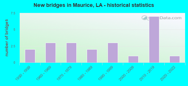
- New bridges - historical statistics
- 21950-1959
- 31960-1969
- 31970-1979
- 21980-1989
- 31990-1999
- 12000-2009
- 72010-2019
- 12020-2022


- Bridge Condition - Deck
- 16.7%Very good
- 38.9%Good
- 33.3%Satisfactory
- 11.1%Fair

- Bridge Condition - Superstructure
- 27.8%Very good
- 27.8%Good
- 33.3%Satisfactory
- 11.1%Fair

- Bridge Condition - Substructure
- 27.8%Very good
- 38.9%Good
- 11.1%Satisfactory
- 11.1%Fair
- 5.6%Poor
- 5.6%Imminent failure

- Bridge Condition - Channel
- 36.4%Very good
- 45.5%Good
- 18.2%Satisfactory
Find on map >> Show street view
Structure Number: 32800000030523, Location: 1.1 MI. W. OF US 167 (Lat: 30.122961, Lng: -92.132711), Route carried "on" structure: County highway , Year Built: 2018, Status: Open, Structure Length: 2.44m (8.01ft), Average Daily Traffic: 1,153 (year 2020), Average Future Daily Traffic: 2,834 (year 2040), Design Load: Greater than HL93, Features Intersected: COULEE, Facility Carried by Structure: LEBLANC RD
Minimum Vertical Clearance: 30+ m (98+ ft), Kilometerpoint: 1.767, Lanes on structure: 2, Owner: County Highway Agency, Approaching Roadway Width: 6.3m (20.7ft), Material/Design: Prestressed concrete, Design/Construction: Stringer/Multi-beam, Number Of Spans In Main Unit: 1, Number Of Approach Spans: 2, Length of Maximum Span: 12.2m (40.0ft), Curb-To-Curb Width: 9.0m (29.5ft), Out-to-Out Width: 10.1m (33.1ft)
Condition: Deck: Very good, Superstructure: Very good, Substructure: Very good, Channel: Very good, Operating Rating: 50.2 metric tons, Method Used To Determine Operating Rating: Load and Resistance Factor Rating (LRFR) rating reported by rating factor(RF) method using HL-93 loadings, Inventory Rating: 32.7 metric tons, Method Used To Determine Inventory Rating: Load and Resistance Factor Rating (LRFR) rating reported by rating factor(RF) method using HL-93 loadings, Structural Evaluation: Equal to present desirable criteria, Deck Geometry: Somewhat better than minimum adequacy, Waterway Adequacy: Equal to present desirable criteria, Approach Roadway Alignment: Equal to present desirable criteria, Designated Inspection Frequency: Every 24 months, Inspection Date: October 2021, Deck Structure Type: Concrete Cast-file-Place
Find on map >> Show street view
Structure Number: 32800000200062, Location: 1.65 MI E of LA 343 (Lat: 30.137061, Lng: -92.148650), Route carried "on" structure: County highway , Year Built: 2013, Status: Open, Structure Length: 1.83m (6.00ft), Average Daily Traffic: 594 (year 2020), Average Future Daily Traffic: 1,460 (year 2040), Design Load: HL 93, Features Intersected: COULEE GRANGES, Facility Carried by Structure: Sellers Rd
Minimum Vertical Clearance: 30+ m (98+ ft), Kilometerpoint: 0.000, Lanes on structure: 2, Owner: County Highway Agency, Approaching Roadway Width: 5.5m (18.0ft), Skew: 31 degrees, Material/Design: Concrete, Design/Construction: Slab, Number Of Spans In Main Unit: 3, Length of Maximum Span: 7.6m (24.9ft), Curb-To-Curb Width: 8.5m (27.9ft), Out-to-Out Width: 9.4m (30.8ft)
Condition: Deck: Very good, Superstructure: Very good, Substructure: Good, Channel: Very good, Operating Rating: 35.6 metric tons, Method Used To Determine Operating Rating: Load and Resistance Factor Rating (LRFR) rating reported by rating factor(RF) method using HL-93 loadings, Inventory Rating: 27.5 metric tons, Method Used To Determine Inventory Rating: Load and Resistance Factor Rating (LRFR) rating reported by rating factor(RF) method using HL-93 loadings, Structural Evaluation: Equal to present minimum criteria, Deck Geometry: Somewhat better than minimum adequacy, Waterway Adequacy: Equal to present desirable criteria, Approach Roadway Alignment: Equal to present desirable criteria, Designated Inspection Frequency: Every 24 months, Inspection Date: October 2021, Deck Structure Type: Other
Find on map >> Show street view
Structure Number: 32800000200143, Location: 0.30 Mi W of US 167 (Lat: 30.125211, Lng: -92.119800), Route carried "on" structure: County highway , Year Built: 2013, Status: Open, Structure Length: 3.66m (12.01ft), Average Daily Traffic: 620 (year 2020), Average Future Daily Traffic: 1,524 (year 2040), Design Load: HS 20, Features Intersected: ILE DES CANNES COULEE, Facility Carried by Structure: Leblanc Rd.
Minimum Vertical Clearance: 30+ m (98+ ft), Kilometerpoint: 0.000, Lanes on structure: 2, Owner: County Highway Agency, Approaching Roadway Width: 6.1m (20.0ft), Skew: 37 degrees, Material/Design: Prestressed concrete continuous, Design/Construction: Stringer/Multi-beam, Number Of Spans In Main Unit: 3, Length of Maximum Span: 12.2m (40.0ft), Curb-To-Curb Width: 9.0m (29.5ft), Out-to-Out Width: 9.9m (32.5ft)
Condition: Deck: Good, Superstructure: Very good, Substructure: Very good, Channel: Good, Operating Rating: 51.5 metric tons, Method Used To Determine Operating Rating: Load and Resistance Factor Rating (LRFR) rating reported by rating factor(RF) method using HL-93 loadings, Inventory Rating: 39.9 metric tons, Method Used To Determine Inventory Rating: Load and Resistance Factor Rating (LRFR) rating reported by rating factor(RF) method using HL-93 loadings, Structural Evaluation: Equal to present desirable criteria, Deck Geometry: Somewhat better than minimum adequacy, Waterway Adequacy: Equal to present minimum criteria, Approach Roadway Alignment: Equal to present desirable criteria, Designated Inspection Frequency: Every 24 months, Underwater Inspection Frequency: Every 60 months, Inspection Date: October 2021, Underwater Inspection Date: July 2018, Deck Structure Type: Concrete Precast Panels, Wearing Surface/Protective System: Wearing Surface: Monolithic Concrete
Find on map >> Show street view
Structure Number: 32800800200002, Location: 2.54 Mi SW of LA 733 (Lat: 30.121669, Lng: -92.119289), Route carried "on" structure: US 167, Year Built: 1984, Status: Open, Structure Length: 5.49m (18.01ft), Average Daily Traffic: 14,900 (year 2016), Truck Traffic: 10%, Average Future Daily Traffic: 22,226 (year 2036), Design Load: HS 20, Features Intersected: COULEE ILE DES CANNES
Minimum Vertical Clearance: 30+ m (98+ ft), Kilometerpoint: 16.219, Lanes on structure: 2, Base Highway Network: Yes (Inventory Route: 80-02-2, Subroute: 10), Owner: State Highway Agency, Approaching Roadway Width: 11.6m (38.1ft), Skew: 10 degrees, Material/Design: Concrete, Design/Construction: Slab, Number Of Spans In Main Unit: 9, Length of Maximum Span: 6.1m (20.0ft), Curb-To-Curb Width: 12.2m (40.0ft), Out-to-Out Width: 13.1m (43.0ft)
Condition: Deck: Satisfactory, Superstructure: Satisfactory, Substructure: Good, Channel: Satisfactory, Operating Rating: 68.0 metric tons, Method Used To Determine Operating Rating: Load Factor (LF), Inventory Rating: 40.8 metric tons, Method Used To Determine Inventory Rating: Load Factor (LF), Structural Evaluation: Equal to present minimum criteria, Deck Geometry: Better than present minimum criteria, Waterway Adequacy: Equal to present desirable criteria, Approach Roadway Alignment: Equal to present desirable criteria, Designated Inspection Frequency: Every 24 months, Underwater Inspection Frequency: Every 60 months, Inspection Date: May 2020, Underwater Inspection Date: August 2018, Deck Structure Type: Concrete Cast-file-Place
Find on map >> Show street view
Structure Number: 32830077920801, Location: 1.29 MI SW of US 167 (Lat: 30.124511, Lng: -92.134300), Route carried "on" structure: County highway , Year Built: 1978, Status: Posted for load, Structure Length: 1.19m (3.90ft), Average Daily Traffic: 210 (year 2020), Average Future Daily Traffic: 516 (year 2040), Design Load: HS 20, Features Intersected: COULEE, Facility Carried by Structure: Denais Rd.
Minimum Vertical Clearance: 30+ m (98+ ft), Kilometerpoint: 0.000, Lanes on structure: 2, Owner: County Highway Agency, Approaching Roadway Width: 5.9m (19.4ft), Material/Design: Concrete, Design/Construction: Slab, Number Of Spans In Main Unit: 2, Length of Maximum Span: 5.8m (19.0ft), Curb-To-Curb Width: 7.4m (24.3ft), Out-to-Out Width: 8.3m (27.2ft)
Condition: Deck: Satisfactory, Superstructure: Satisfactory, Substructure: Poor, Channel: Satisfactory, Operating Rating: 24.6 metric tons, Method Used To Determine Operating Rating: Load and Resistance Factor Rating (LRFR) rating reported by rating factor(RF) method using HL-93 loadings, Inventory Rating: 18.8 metric tons, Method Used To Determine Inventory Rating: Load and Resistance Factor Rating (LRFR) rating reported by rating factor(RF) method using HL-93 loadings, Structural Evaluation: Meets minimum limits, Deck Geometry: Somewhat better than minimum adequacy, Waterway Adequacy: Equal to present minimum criteria, Approach Roadway Alignment: Equal to present desirable criteria, Bridge Posting: Required (Relationship of Operating Rating to Maximum Legal Load: 0.1 - 9.9% below), Designated Inspection Frequency: Every 24 months, Other Special Inspection Frequency: Every 12 months, Inspection Date: October 2021, Other Special Inspection Date: October 2020, Deck Structure Type: Concrete Precast Panels
Find on map >> Show street view
Structure Number: 32830080920671, Location: 1.9 Mi NW of US 167 (Lat: 30.134489, Lng: -92.114731), Route carried "on" structure: County highway , Year Built: 1974, Year Reconstructed: 1992, Status: Posted for load, Structure Length: 3.51m (11.52ft), Average Daily Traffic: 800 (year 2020), Average Future Daily Traffic: 1,967 (year 2040), Design Load: HS 20, Features Intersected: ILE DES CANNES COULEE, Facility Carried by Structure: Bourque Rd
Minimum Vertical Clearance: 30+ m (98+ ft), Kilometerpoint: 0.000, Lanes on structure: 2, Owner: County Highway Agency, Approaching Roadway Width: 6.4m (21.0ft), Material/Design: Concrete, Design/Construction: Slab, Number Of Spans In Main Unit: 6, Length of Maximum Span: 5.8m (19.0ft), Curb-To-Curb Width: 7.4m (24.3ft), Out-to-Out Width: 8.4m (27.6ft)
Condition: Deck: Fair, Superstructure: Fair, Substructure: Fair, Channel: Good, Operating Rating: 21.4 metric tons, Method Used To Determine Operating Rating: Load and Resistance Factor Rating (LRFR) rating reported by rating factor(RF) method using HL-93 loadings, Inventory Rating: 16.5 metric tons, Method Used To Determine Inventory Rating: Load and Resistance Factor Rating (LRFR) rating reported by rating factor(RF) method using HL-93 loadings, Structural Evaluation: Meets minimum limits, Deck Geometry: Meets minimum limits, Waterway Adequacy: Equal to present minimum criteria, Approach Roadway Alignment: High priority of corrective action, Bridge Posting: Required (Relationship of Operating Rating to Maximum Legal Load: 20.0 - 29.9% below), Length Of Structure Improvement: 4.39m (14.40ft), Designated Inspection Frequency: Every 24 months, Underwater Inspection Frequency: Every 60 months, Inspection Date: October 2021, Underwater Inspection Date: August 2018, Bridge Improvement Cost: $262,000, Total Project Cost: $393,000 ( Estimate for 2016), Deck Structure Type: Concrete Precast Panels
Find on map >> Show street view
Structure Number: 32830093920851, Location: 0.3 MI S of LA 342 (Lat: 30.155189, Lng: -92.141750), Route carried "on" structure: County highway , Year Built: 1996, Status: Open, Structure Length: 2.32m (7.61ft), Average Daily Traffic: 1,400 (year 2020), Average Future Daily Traffic: 3,442 (year 2040), Design Load: HS 20, Features Intersected: GRANGES COULEE, Facility Carried by Structure: S. Fieldspan Rd.
Minimum Vertical Clearance: 30+ m (98+ ft), Kilometerpoint: 0.000, Lanes on structure: 2, Base Highway Network: Yes, Owner: County Highway Agency, Approaching Roadway Width: 6.2m (20.3ft), Material/Design: Concrete, Design/Construction: Slab, Number Of Spans In Main Unit: 4, Length of Maximum Span: 5.8m (19.0ft), Curb-To-Curb Width: 8.5m (27.9ft), Out-to-Out Width: 9.4m (30.8ft)
Condition: Deck: Good, Superstructure: Good, Substructure: Good, Channel: Very good, Operating Rating: 25.3 metric tons, Method Used To Determine Operating Rating: Load and Resistance Factor Rating (LRFR) rating reported by rating factor(RF) method using HL-93 loadings, Inventory Rating: 19.8 metric tons, Method Used To Determine Inventory Rating: Load and Resistance Factor Rating (LRFR) rating reported by rating factor(RF) method using HL-93 loadings, Structural Evaluation: Somewhat better than minimum adequacy, Deck Geometry: Somewhat better than minimum adequacy, Waterway Adequacy: Equal to present desirable criteria, Approach Roadway Alignment: Equal to present desirable criteria, Designated Inspection Frequency: Every 24 months, Inspection Date: October 2021, Deck Structure Type: Concrete Cast-file-Place, Wearing Surface/Protective System: Wearing Surface: Monolithic Concrete
Find on map >> Show street view
Structure Number: 35700000030002, Location: 1 Mi E of La 14 (Lat: 30.021711, Lng: -92.479519), Route carried "on" structure: County highway , Year Built: 2019, Status: Open, Structure Length: 1.80m (5.91ft), Average Daily Traffic: 58 (year 2019), Average Future Daily Traffic: 64 (year 2039), Features Intersected: Maree Michel Canal, Facility Carried by Structure: Maree Michel Rd
Minimum Vertical Clearance: 30+ m (98+ ft), Kilometerpoint: 3.296, Lanes on structure: 2, Owner: County Highway Agency, Approaching Roadway Width: 4.7m (15.4ft), Material/Design: Wood or Timber, Design/Construction: Stringer/Multi-beam, Number Of Spans In Main Unit: 3, Length of Maximum Span: 6.1m (20.0ft), Curb-To-Curb Width: 6.9m (22.6ft), Out-to-Out Width: 7.3m (24.0ft)
Condition: Deck: Good, Superstructure: Very good, Substructure: Good, Channel: Good, Operating Rating: 34.5 metric tons, Method Used To Determine Operating Rating: Allowable Stress (AS), Inventory Rating: 25.4 metric tons, Method Used To Determine Inventory Rating: Allowable Stress (AS), Structural Evaluation: Equal to present minimum criteria, Deck Geometry: Somewhat better than minimum adequacy, Waterway Adequacy: Equal to present desirable criteria, Approach Roadway Alignment: Equal to present desirable criteria, Designated Inspection Frequency: Every 24 months, Underwater Inspection Frequency: Every 60 months, Inspection Date: July 2021, Underwater Inspection Date: June 2021, Deck Structure Type: Wood or Timber
Find on map >> Show street view
Structure Number: 35700000030073, Location: 0.8 MI S. OF LA 699 (Lat: 30.067319, Lng: -92.132839), Route carried "on" structure: County highway , Year Built: 2014, Status: Posted for load, Structure Length: 1.16m (3.81ft), Average Daily Traffic: 725 (year 2021), Average Future Daily Traffic: 798 (year 2041), Design Load: HS 20, Features Intersected: COULEE, Facility Carried by Structure: Beau Rd
Minimum Vertical Clearance: 30+ m (98+ ft), Kilometerpoint: 0.000, Lanes on structure: 2, Owner: County Highway Agency, Approaching Roadway Width: 4.9m (16.1ft), Skew: 32 degrees, Material/Design: Concrete, Design/Construction: Slab, Number Of Spans In Main Unit: 2, Length of Maximum Span: 5.8m (19.0ft), Curb-To-Curb Width: 6.8m (22.3ft), Out-to-Out Width: 6.9m (22.6ft)
Condition: Deck: Satisfactory, Superstructure: Satisfactory, Substructure: Very good, Channel: Very good, Operating Rating: 40.8 metric tons, Method Used To Determine Operating Rating: Load and Resistance Factor Rating (LRFR) rating reported by rating factor(RF) method using HL-93 loadings, Inventory Rating: 31.4 metric tons, Method Used To Determine Inventory Rating: Load and Resistance Factor Rating (LRFR) rating reported by rating factor(RF) method using HL-93 loadings, Structural Evaluation: Equal to present minimum criteria, Deck Geometry: Meets minimum limits, Waterway Adequacy: Equal to present desirable criteria, Approach Roadway Alignment: Equal to present desirable criteria, Designated Inspection Frequency: Every 24 months, Inspection Date: September 2021, Deck Structure Type: Concrete Cast-file-Place, Wearing Surface/Protective System: Wearing Surface: Bituminous
Find on map >> Show street view
Structure Number: 35700000030479, Location: 0.01 MI. S. OF LA 92 (Lat: 30.106600, Lng: -92.155981), Route carried "on" structure: County highway , Year Built: 2016, Status: Posted for load, Structure Length: 0.98m (3.22ft), Average Daily Traffic: 150 (year 2022), Average Future Daily Traffic: 190 (year 2042), Features Intersected: Granger Coulee, Facility Carried by Structure: Bella Rd
Minimum Vertical Clearance: 30+ m (98+ ft), Kilometerpoint: 0.016, Lanes on structure: 2, Owner: County Highway Agency, Approaching Roadway Width: 4.3m (14.1ft), Material/Design: Wood or Timber, Design/Construction: Stringer/Multi-beam, Number Of Spans In Main Unit: 3, Length of Maximum Span: 5.8m (19.0ft), Curb-To-Curb Width: 6.8m (22.3ft), Out-to-Out Width: 7.2m (23.6ft)
Condition: Deck: Good, Superstructure: Good, Substructure: Good, Channel: Good, Operating Rating: 31.7 metric tons, Method Used To Determine Operating Rating: Allowable Stress (AS), Inventory Rating: 23.6 metric tons, Method Used To Determine Inventory Rating: Allowable Stress (AS), Structural Evaluation: Equal to present minimum criteria, Deck Geometry: Meets minimum limits, Waterway Adequacy: Better than present minimum criteria, Approach Roadway Alignment: Equal to present desirable criteria, Designated Inspection Frequency: Every 24 months, Inspection Date: September 2021, Deck Structure Type: Wood or Timber
Find on map >> Show street view
Structure Number: 35700000035701, Location: 0.2 Mi E. of US167 (Lat: 30.064900, Lng: -92.119269), Route carried "on" structure: County highway , Year Built: 2020, Status: Posted for load, Structure Length: 1.10m (3.61ft), Average Daily Traffic: 749 (year 2022), Average Future Daily Traffic: 935 (year 2042), Design Load: HS 20, Features Intersected: Coulee, Facility Carried by Structure: Placide Rd
Minimum Vertical Clearance: 30+ m (98+ ft), Kilometerpoint: 3.323, Lanes on structure: 2, Owner: County Highway Agency, Approaching Roadway Width: 5.7m (18.7ft), Material/Design: Wood or Timber, Design/Construction: Stringer/Multi-beam, Number Of Spans In Main Unit: 2, Length of Maximum Span: 5.5m (18.0ft), Curb-To-Curb Width: 6.9m (22.6ft), Out-to-Out Width: 7.6m (24.9ft)
Condition: Deck: Very good, Superstructure: Very good, Substructure: Very good, Channel: Very good, Operating Rating: 34.5 metric tons, Method Used To Determine Operating Rating: Allowable Stress (AS), Inventory Rating: 25.4 metric tons, Method Used To Determine Inventory Rating: Allowable Stress (AS), Structural Evaluation: Equal to present minimum criteria, Deck Geometry: Meets minimum limits, Waterway Adequacy: Equal to present desirable criteria, Approach Roadway Alignment: Superior to present desirable criteria, Designated Inspection Frequency: Every 24 months, Inspection Date: September 2021, Deck Structure Type: Wood or Timber, Wearing Surface/Protective System: Wearing Surface: Bituminous
Find on map >> Show street view
Structure Number: 35700000300036, Location: 1.12 MI E OF LA 343 (Lat: 30.119361, Lng: -92.160900), Route carried "on" structure: County highway , Year Built: 2000, Status: Open, Structure Length: 1.83m (6.00ft), Average Daily Traffic: 200 (year 2021), Average Future Daily Traffic: 220 (year 2041), Design Load: HS 20, Features Intersected: GRANGERS CANAL, Facility Carried by Structure: Cedric Rd
Minimum Vertical Clearance: 30+ m (98+ ft), Kilometerpoint: 0.000, Lanes on structure: 2, Owner: County Highway Agency, Approaching Roadway Width: 5.0m (16.4ft), Skew: 30 degrees, Material/Design: Concrete, Design/Construction: Slab, Number Of Spans In Main Unit: 3, Length of Maximum Span: 6.1m (20.0ft), Curb-To-Curb Width: 7.3m (24.0ft), Out-to-Out Width: 8.3m (27.2ft)
Condition: Deck: Good, Superstructure: Good, Substructure: Very good, Channel: Very good, Operating Rating: 51.5 metric tons, Method Used To Determine Operating Rating: Load and Resistance Factor Rating (LRFR) rating reported by rating factor(RF) method using HL-93 loadings, Inventory Rating: 39.9 metric tons, Method Used To Determine Inventory Rating: Load and Resistance Factor Rating (LRFR) rating reported by rating factor(RF) method using HL-93 loadings, Structural Evaluation: Better than present minimum criteria, Deck Geometry: Somewhat better than minimum adequacy, Waterway Adequacy: Better than present minimum criteria, Approach Roadway Alignment: Equal to present desirable criteria, Designated Inspection Frequency: Every 24 months, Inspection Date: September 2021, Deck Structure Type: Concrete Cast-file-Place, Wearing Surface/Protective System: Wearing Surface: Monolithic Concrete
Find on map >> Show street view
Structure Number: 35700800105551, Location: 0.5 MI N. OF LA 696 (Lat: 30.049969, Lng: -92.124139), Route carried "on" structure: US 167, Year Built: 1954, Status: Open, Structure Length: 1.34m (4.40ft), Average Daily Traffic: 19,800 (year 2016), Truck Traffic: 24%, Average Future Daily Traffic: 24,570 (year 2036), Design Load: HS 20, Features Intersected: CANAL
Minimum Vertical Clearance: 30+ m (98+ ft), Kilometerpoint: 8.901, Lanes on structure: 5, Base Highway Network: Yes (Inventory Route: 80-01-1, Subroute: 10), Owner: State Highway Agency, Approaching Roadway Width: 25.9m (85.0ft), Skew: 10 degrees, Material/Design: Concrete, Design/Construction: Culvert, Number Of Spans In Main Unit: 4, Length of Maximum Span: 3.0m (9.8ft)
Condition: Channel: Good, Culverts: Good, Operating Rating: 42.1 metric tons, Method Used To Determine Operating Rating: Load and Resistance Factor Rating (LRFR) rating reported by rating factor(RF) method using HL-93 loadings, Inventory Rating: 32.4 metric tons, Method Used To Determine Inventory Rating: Load and Resistance Factor Rating (LRFR) rating reported by rating factor(RF) method using HL-93 loadings, Structural Evaluation: Better than present minimum criteria, Waterway Adequacy: Better than present minimum criteria, Approach Roadway Alignment: Equal to present desirable criteria, Designated Inspection Frequency: Every 24 months, Inspection Date: June 2020, Deck Structure Type: Concrete Cast-file-Place
Find on map >> Show street view
Structure Number: 35700800106111, Location: 1.04 MI N. OF LA 696 (Lat: 30.057639, Lng: -92.123911), Route carried "on" structure: US 167, Year Built: 1988, Status: Open, Structure Length: 1.31m (4.30ft), Average Daily Traffic: 19,800 (year 2016), Truck Traffic: 24%, Average Future Daily Traffic: 24,570 (year 2036), Design Load: HS 20, Features Intersected: DRAINAGE CANAL
Minimum Vertical Clearance: 30+ m (98+ ft), Kilometerpoint: 10.057, Lanes on structure: 2, Base Highway Network: Yes (Inventory Route: 80-01-1, Subroute: 10), Owner: State Highway Agency, Approaching Roadway Width: 7.3m (24.0ft), Material/Design: Concrete, Design/Construction: Culvert, Number Of Spans In Main Unit: 4, Length of Maximum Span: 2.4m (7.9ft), Curb-To-Curb Width: 16.5m (54.1ft), Out-to-Out Width: 17.1m (56.1ft)
Condition: Channel: Very good, Culverts: Good, Operating Rating: 42.1 metric tons, Method Used To Determine Operating Rating: Load and Resistance Factor Rating (LRFR) rating reported by rating factor(RF) method using HL-93 loadings, Inventory Rating: 32.4 metric tons, Method Used To Determine Inventory Rating: Load and Resistance Factor Rating (LRFR) rating reported by rating factor(RF) method using HL-93 loadings, Structural Evaluation: Better than present minimum criteria, Deck Geometry: Superior to present desirable criteria, Waterway Adequacy: Equal to present desirable criteria, Approach Roadway Alignment: Equal to present desirable criteria, Designated Inspection Frequency: Every 24 months, Inspection Date: June 2021, Deck Structure Type: Concrete Cast-file-Place
Find on map >> Show street view
Structure Number: 35700800106291, Location: 1.22 MI N. OF LA 696 (Lat: 30.060481, Lng: -92.124031), Route carried "on" structure: US 167, Year Built: 1954, Year Reconstructed: 1988, Status: Open, Structure Length: 1.95m (6.40ft), Average Daily Traffic: 19,800 (year 2016), Truck Traffic: 24%, Average Future Daily Traffic: 24,570 (year 2036), Design Load: HS 20, Features Intersected: CANAL
Minimum Vertical Clearance: 30+ m (98+ ft), Kilometerpoint: 10.058, Lanes on structure: 4, Base Highway Network: Yes (Inventory Route: 80-01-1, Subroute: 10), Owner: State Highway Agency, Approaching Roadway Width: 23.2m (76.1ft), Skew: 14 degrees, Material/Design: Concrete, Design/Construction: Culvert, Number Of Spans In Main Unit: 5, Length of Maximum Span: 2.4m (7.9ft), Curb-To-Curb Width: 23.2m (76.1ft), Out-to-Out Width: 63.4m (208.0ft)
Condition: Channel: Good, Culverts: Good, Operating Rating: 42.1 metric tons, Method Used To Determine Operating Rating: Load and Resistance Factor Rating (LRFR) rating reported by rating factor(RF) method using HL-93 loadings, Inventory Rating: 32.4 metric tons, Method Used To Determine Inventory Rating: Load and Resistance Factor Rating (LRFR) rating reported by rating factor(RF) method using HL-93 loadings, Structural Evaluation: Better than present minimum criteria, Deck Geometry: Superior to present desirable criteria, Waterway Adequacy: Better than present minimum criteria, Approach Roadway Alignment: Equal to present desirable criteria, Designated Inspection Frequency: Every 24 months, Inspection Date: June 2020, Deck Structure Type: Concrete Cast-file-Place
Find on map >> Show street view
Structure Number: 35702130305001, Location: 1.0 MI E. OF LA 343 (Lat: 30.108439, Lng: -92.159400), Route carried "on" structure: State highway 92, Year Built: 1961, Status: Open, Structure Length: 0.70m (2.30ft), Average Daily Traffic: 5,300 (year 2016), Truck Traffic: 9%, Average Future Daily Traffic: 6,552 (year 2036), Design Load: H 15, Features Intersected: CREEK
Minimum Vertical Clearance: 30+ m (98+ ft), Kilometerpoint: 8.010, Lanes on structure: 2, Owner: State Highway Agency, Approaching Roadway Width: 13.4m (44.0ft), Material/Design: Concrete, Design/Construction: Culvert, Number Of Spans In Main Unit: 4, Length of Maximum Span: 1.5m (4.9ft), Curb-To-Curb Width: 11.9m (39.0ft), Out-to-Out Width: 11.9m (39.0ft)
Condition: Channel: Good, Culverts: Good, Operating Rating: 42.1 metric tons, Method Used To Determine Operating Rating: Load and Resistance Factor Rating (LRFR) rating reported by rating factor(RF) method using HL-93 loadings, Inventory Rating: 32.4 metric tons, Method Used To Determine Inventory Rating: Load and Resistance Factor Rating (LRFR) rating reported by rating factor(RF) method using HL-93 loadings, Structural Evaluation: Better than present minimum criteria, Deck Geometry: Somewhat better than minimum adequacy, Waterway Adequacy: Better than present minimum criteria, Approach Roadway Alignment: Equal to present desirable criteria, Designated Inspection Frequency: Every 24 months, Inspection Date: December 2020, Deck Structure Type: Concrete Cast-file-Place
Find on map >> Show street view
Structure Number: 35702130306431, Location: 2.43 MI E. OF LA 343 (Lat: 30.108581, Lng: -92.136000), Route carried "on" structure: State highway 92, Year Built: 1961, Status: Open, Structure Length: 3.05m (10.01ft), Average Daily Traffic: 5,300 (year 2016), Truck Traffic: 9%, Average Future Daily Traffic: 6,552 (year 2036), Design Load: HS 20, Features Intersected: COULEE GRANGES
Minimum Vertical Clearance: 30+ m (98+ ft), Kilometerpoint: 10.263, Lanes on structure: 2, Owner: State Highway Agency, Approaching Roadway Width: 11.9m (39.0ft), Skew: 4 degrees, Material/Design: Concrete, Design/Construction: Slab, Number Of Spans In Main Unit: 5, Length of Maximum Span: 6.1m (20.0ft), Curb-To-Curb Width: 7.4m (24.3ft), Out-to-Out Width: 9.1m (29.9ft)
Condition: Deck: Good, Superstructure: Good, Substructure: Good, Channel: Satisfactory, Operating Rating: 45.4 metric tons, Method Used To Determine Operating Rating: Load Factor (LF), Inventory Rating: 27.2 metric tons, Method Used To Determine Inventory Rating: Load Factor (LF), Structural Evaluation: Equal to present minimum criteria, Deck Geometry: High priority of replacement, Waterway Adequacy: Equal to present minimum criteria, Approach Roadway Alignment: Equal to present desirable criteria, Length Of Structure Improvement: 3.90m (12.80ft), Designated Inspection Frequency: Every 24 months, Inspection Date: December 2020, Bridge Improvement Cost: $332,000, Total Project Cost: $498,000 ( Estimate for 2016), Deck Structure Type: Concrete Cast-file-Place
Find on map >> Show street view
Structure Number: 35708570606201, Location: 0.3 MI W OF LA 167 (Lat: 30.042961, Lng: -92.129000), Route carried "on" structure: State highway 697, Year Built: 1976, Status: Open, Structure Length: 2.32m (7.61ft), Average Daily Traffic: 990 (year 2016), Truck Traffic: 15%, Average Future Daily Traffic: 1,285 (year 2036), Design Load: HS 20, Features Intersected: COULEE KENNYS
Minimum Vertical Clearance: 30+ m (98+ ft), Kilometerpoint: 5.238, Lanes on structure: 2, Owner: State Highway Agency, Approaching Roadway Width: 7.6m (24.9ft), Material/Design: Concrete, Design/Construction: Slab, Number Of Spans In Main Unit: 4, Length of Maximum Span: 5.8m (19.0ft), Curb-To-Curb Width: 8.6m (28.2ft), Out-to-Out Width: 9.4m (30.8ft)
Condition: Deck: Satisfactory, Superstructure: Satisfactory, Substructure: Fair, Channel: Good, Operating Rating: 32.1 metric tons, Method Used To Determine Operating Rating: Load and Resistance Factor Rating (LRFR) rating reported by rating factor(RF) method using HL-93 loadings, Inventory Rating: 24.6 metric tons, Method Used To Determine Inventory Rating: Load and Resistance Factor Rating (LRFR) rating reported by rating factor(RF) method using HL-93 loadings, Structural Evaluation: Somewhat better than minimum adequacy, Deck Geometry: Somewhat better than minimum adequacy, Waterway Adequacy: Equal to present desirable criteria, Approach Roadway Alignment: Equal to present desirable criteria, Designated Inspection Frequency: Every 24 months, Inspection Date: December 2021, Deck Structure Type: Concrete Precast Panels, Wearing Surface/Protective System: Wearing Surface: Bituminous
Find on map >> Show street view
Structure Number: 35730038920761, Location: 0.01 Mi S of Placide Rd (Lat: 30.064319, Lng: -92.128531), Route carried "on" structure: County highway , Year Built: 1992, Status: Closed, Structure Length: 1.13m (3.71ft), Average Daily Traffic: 100 (year 2022), Average Future Daily Traffic: 125 (year 2042), Design Load: H 15, Features Intersected: COULEE, Facility Carried by Structure: Roy Rd
Minimum Vertical Clearance: 30+ m (98+ ft), Kilometerpoint: 0.000, Lanes on structure: 2, Owner: County Highway Agency, Approaching Roadway Width: 6.7m (22.0ft), Material/Design: Wood or Timber, Design/Construction: Stringer/Multi-beam, Number Of Spans In Main Unit: 3, Length of Maximum Span: 5.8m (19.0ft), Curb-To-Curb Width: 7.1m (23.3ft), Out-to-Out Width: 7.5m (24.6ft)
Condition: Deck: Fair, Superstructure: Fair, Substructure: Imminent failure, Channel: Good, Deck Geometry: Somewhat better than minimum adequacy, Waterway Adequacy: Somewhat better than minimum adequacy, Approach Roadway Alignment: Equal to present desirable criteria, Bridge Posting: Required (Relationship of Operating Rating to Maximum Legal Load: > 39.9% below), Designated Inspection Frequency: Every 24 months, Other Special Inspection Frequency: Every 6 months, Inspection Date: September 2021, Other Special Inspection Date: August 2021, Deck Structure Type: Wood or Timber, Wearing Surface/Protective System: Wearing Surface: Other
Find on map >> Show street view
Structure Number: 35730039920751, Location: 0.02 Mi W of US 167 (Lat: 30.064861, Lng: -92.124611), Route carried "on" structure: County highway , Year Built: 1996, Status: Open, Structure Length: 1.74m (5.71ft), Average Daily Traffic: 720 (year 2022), Average Future Daily Traffic: 900 (year 2042), Design Load: HS 20, Features Intersected: COULEE, Facility Carried by Structure: Placide Rd
Minimum Vertical Clearance: 30+ m (98+ ft), Kilometerpoint: 0.000, Lanes on structure: 2, Base Highway Network: Yes, Owner: County Highway Agency, Approaching Roadway Width: 5.6m (18.4ft), Skew: 7 degrees, Material/Design: Concrete, Design/Construction: Slab, Number Of Spans In Main Unit: 3, Length of Maximum Span: 5.8m (19.0ft), Curb-To-Curb Width: 8.5m (27.9ft), Out-to-Out Width: 9.4m (30.8ft)
Condition: Deck: Satisfactory, Superstructure: Satisfactory, Substructure: Good, Channel: Very good, Operating Rating: 48.6 metric tons, Method Used To Determine Operating Rating: Load and Resistance Factor Rating (LRFR) rating reported by rating factor(RF) method using HL-93 loadings, Inventory Rating: 37.6 metric tons, Method Used To Determine Inventory Rating: Load and Resistance Factor Rating (LRFR) rating reported by rating factor(RF) method using HL-93 loadings, Structural Evaluation: Equal to present minimum criteria, Deck Geometry: Somewhat better than minimum adequacy, Waterway Adequacy: Equal to present desirable criteria, Approach Roadway Alignment: Equal to present desirable criteria, Designated Inspection Frequency: Every 24 months, Inspection Date: September 2021, Deck Structure Type: Concrete Precast Panels, Wearing Surface/Protective System: Wearing Surface: Monolithic Concrete
Find on map >> Show street view
Structure Number: 35730039920771, Location: 0.3 Mi W of US 167 (Lat: 30.064831, Lng: -92.129411), Route carried "on" structure: County highway , Year Built: 1965, Status: Posted for load, Structure Length: 1.19m (3.90ft), Average Daily Traffic: 720 (year 2022), Average Future Daily Traffic: 900 (year 2042), Design Load: H 10, Features Intersected: COULEE, Facility Carried by Structure: Placide Rd.
Minimum Vertical Clearance: 30+ m (98+ ft), Kilometerpoint: 0.000, Lanes on structure: 2, Owner: County Highway Agency, Approaching Roadway Width: 7.6m (24.9ft), Material/Design: Wood or Timber, Design/Construction: Stringer/Multi-beam, Number Of Spans In Main Unit: 2, Length of Maximum Span: 6.1m (20.0ft), Curb-To-Curb Width: 5.8m (19.0ft), Out-to-Out Width: 6.2m (20.3ft)
Condition: Deck: Satisfactory, Superstructure: Satisfactory, Substructure: Satisfactory, Channel: Satisfactory, Operating Rating: 16.3 metric tons, Method Used To Determine Operating Rating: Allowable Stress (AS), Inventory Rating: 10.9 metric tons, Method Used To Determine Inventory Rating: Allowable Stress (AS), Structural Evaluation: High priority of replacement, Deck Geometry: High priority of replacement, Waterway Adequacy: Equal to present minimum criteria, Approach Roadway Alignment: Equal to present desirable criteria, Bridge Posting: Required (Relationship of Operating Rating to Maximum Legal Load: 20.0 - 29.9% below), Length Of Structure Improvement: 1.83m (6.00ft), Designated Inspection Frequency: Every 24 months, Inspection Date: September 2021, Bridge Improvement Cost: $109,000, Total Project Cost: $163,000 ( Estimate for 2016), Deck Structure Type: Wood or Timber, Wearing Surface/Protective System: Wearing Surface: Bituminous
Find on map >> Show street view
Structure Number: 35730064920841, Location: 0.1 Mi S of LA 92 (Lat: 30.106700, Lng: -92.140000), Route carried "on" structure: County highway , Year Built: 2011, Status: Open, Structure Length: 2.32m (7.61ft), Average Daily Traffic: 291 (year 2021), Average Future Daily Traffic: 320 (year 2041), Design Load: H 10, Features Intersected: GRANGES COULEE, Facility Carried by Structure: Pressley Rd
Minimum Vertical Clearance: 30+ m (98+ ft), Kilometerpoint: 0.000, Lanes on structure: 2, Owner: County Highway Agency, Approaching Roadway Width: 5.1m (16.7ft), Skew: 30 degrees, Material/Design: Concrete, Design/Construction: Slab, Number Of Spans In Main Unit: 4, Length of Maximum Span: 5.8m (19.0ft), Curb-To-Curb Width: 7.3m (24.0ft), Out-to-Out Width: 8.2m (26.9ft)
Condition: Deck: Good, Superstructure: Good, Substructure: Satisfactory, Channel: Good, Operating Rating: 47.3 metric tons, Method Used To Determine Operating Rating: Load and Resistance Factor Rating (LRFR) rating reported by rating factor(RF) method using HL-93 loadings, Inventory Rating: 36.3 metric tons, Method Used To Determine Inventory Rating: Load and Resistance Factor Rating (LRFR) rating reported by rating factor(RF) method using HL-93 loadings, Structural Evaluation: Equal to present minimum criteria, Deck Geometry: Somewhat better than minimum adequacy, Waterway Adequacy: Equal to present minimum criteria, Approach Roadway Alignment: Equal to present minimum criteria, Designated Inspection Frequency: Every 24 months, Inspection Date: September 2021, Deck Structure Type: Wood or Timber, Wearing Surface/Protective System: Wearing Surface: Wood or Timber