Bridge Statistics for Mayer, Arizona (AZ)
Condition, Traffic, Stress, Structural Evaluation, Project Costs
- National Bridge Inventory (NBI) Statistics
- 16Number of bridges
- 269ft / 81.8mTotal length
- $90,000Total costs
- 202,175Total average daily traffic
- 21,898Total average daily truck traffic
- 216,101Total future (year 2037) average daily traffic
- National Bridge Inventory (NBI) Registered Bridges for Mayer
- No street view available for this location
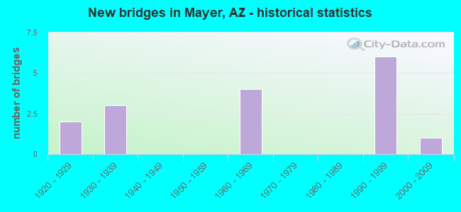
- New bridges - historical statistics
- 21920-1929
- 31930-1939
- 41960-1969
- 61990-1999
- 12000-2009

- Reconstructed bridges - Historical Statistics
- 11940-1949
- 21950-1959
- 11960-1969


- Bridge Condition - Deck
- 33.3%Good
- 33.3%Satisfactory
- 33.3%Fair

- Bridge Condition - Superstructure
- 6.7%Very good
- 40.0%Good
- 33.3%Satisfactory
- 20.0%Fair

- Bridge Condition - Substructure
- 6.7%Very good
- 60.0%Good
- 26.7%Satisfactory
- 6.7%Fair

- Bridge Condition - Channel
- 10.0%Very good
- 70.0%Good
- 20.0%Satisfactory
Find on map >> Show street view
Structure Number: 98, Location: 9.7 mi N Jct SR 82 (Lat: 31.856400, Lng: -110.201900), Route carried "on" structure: State highway 80, Year Built: 1933, Year Reconstructed: 1956, Status: Open, Structure Length: 1.40m (4.59ft), Average Daily Traffic: 3,206 (year 2019), Truck Traffic: 18%, Average Future Daily Traffic: 4,987 (year 2039), Design Load: HS 20, Features Intersected: Dry Wash
Minimum Vertical Clearance: 30+ m (98+ ft), Kilometerpoint: 489.466, Lanes on structure: 2, Owner: State Highway Agency, Approaching Roadway Width: 10.4m (34.1ft), Material/Design: Concrete continuous, Design/Construction: Slab, Number Of Spans In Main Unit: 2, Length of Maximum Span: 6.7m (22.0ft), Curb-To-Curb Width: 10.5m (34.4ft), Out-to-Out Width: 11.5m (37.7ft)
Condition: Deck: Satisfactory, Superstructure: Satisfactory, Substructure: Satisfactory, Channel: Satisfactory, Operating Rating: 65.3 metric tons, Method Used To Determine Operating Rating: Load Factor (LF), Inventory Rating: 39.0 metric tons, Method Used To Determine Inventory Rating: Load Factor (LF), Structural Evaluation: Equal to present minimum criteria, Deck Geometry: Somewhat better than minimum adequacy, Waterway Adequacy: Better than present minimum criteria, Approach Roadway Alignment: Equal to present desirable criteria, Designated Inspection Frequency: Every 24 months, Inspection Date: March 2021, Deck Structure Type: Concrete Cast-file-Place, Wearing Surface/Protective System: Wearing Surface: Bituminous
Find on map >> Show street view
Structure Number: 99, Location: 16.3 mi E Jct SR 88 (Lat: 33.587600, Lng: -110.648700), Route carried "on" structure: US 60, Year Built: 1933, Year Reconstructed: 1960, Status: Open, Structure Length: 4.88m (16.01ft), Average Daily Traffic: 2,788 (year 2019), Truck Traffic: 11%, Average Future Daily Traffic: 4,309 (year 2040), Design Load: HS 20, Features Intersected: Seven Mile Wash
Minimum Vertical Clearance: 30+ m (98+ ft), Kilometerpoint: 431.626, Lanes on structure: 2, Owner: State Highway Agency, Approaching Roadway Width: 10.7m (35.1ft), Skew: 3 degrees, Material/Design: Concrete, Design/Construction: Tee Beam, Number Of Spans In Main Unit: 4, Length of Maximum Span: 12.2m (40.0ft), Curb-To-Curb Width: 10.8m (35.4ft), Out-to-Out Width: 11.6m (38.1ft)
Condition: Deck: Fair, Superstructure: Fair, Substructure: Fair, Channel: Good, Operating Rating: 64.4 metric tons, Method Used To Determine Operating Rating: Load Factor (LF), Inventory Rating: 38.1 metric tons, Method Used To Determine Inventory Rating: Load Factor (LF), Structural Evaluation: Somewhat better than minimum adequacy, Deck Geometry: Somewhat better than minimum adequacy, Waterway Adequacy: Better than present minimum criteria, Approach Roadway Alignment: Equal to present desirable criteria, Designated Inspection Frequency: Every 24 months, Inspection Date: October 2020, Deck Structure Type: Concrete Cast-file-Place, Wearing Surface/Protective System: Wearing Surface: Bituminous
Find on map >> Show street view
Structure Number: 1, Location: 0.1 mi W Jct US 93 (Lat: 33.968200, Lng: -112.730900), Route carried "on" structure: City street , Year Built: 1937, Year Reconstructed: 1958, Status: Open, Structure Length: 1.92m (6.30ft), Average Daily Traffic: 500 (year 2019), Truck Traffic: 5%, Average Future Daily Traffic: 510 (year 2039), Design Load: HS 20, Features Intersected: US 60, Facility Carried by Structure: Frontier Street
Minimum Vertical Clearance: 30+ m (98+ ft), Kilometerpoint: 0.000, Lanes on structure: 2, Lanes under structure: 4, Owner: State Highway Agency, Approaching Roadway Width: 11.0m (36.1ft), Material/Design: Concrete continuous, Design/Construction: Frame, Number Of Spans In Main Unit: 2, Length of Maximum Span: 10.1m (33.1ft), Curb or Sidewalk Widths: Left: 0.4m (1.3ft), Right: 1.2m (3.9ft), Curb-To-Curb Width: 7.3m (24.0ft), Out-to-Out Width: 9.5m (31.2ft)
Condition: Deck: Satisfactory, Superstructure: Satisfactory, Substructure: Good, Operating Rating: 37.2 metric tons, Method Used To Determine Operating Rating: Load Factor (LF), Inventory Rating: 21.8 metric tons, Method Used To Determine Inventory Rating: Load Factor (LF), Structural Evaluation: Equal to present minimum criteria, Deck Geometry: Meets minimum limits, Underclear: High priority of replacement, Approach Roadway Alignment: Equal to present minimum criteria, Length Of Structure Improvement: 2.71m (8.89ft), Designated Inspection Frequency: Every 24 months, Inspection Date: November 2021, Total Project Cost: $1,000 ( Estimate for 2021), Deck Structure Type: Concrete Cast-file-Place, Wearing Surface/Protective System: Wearing Surface: Monolithic Concrete
Find on map >> Show street view
Structure Number: 101, Location: 6.1 mi W Jct SR 85 (Lat: 32.927500, Lng: -112.835600), Route carried "on" structure: ServiceState highway 8, Year Built: 1923, Year Reconstructed: 1949, Status: Open, Structure Length: 1.62m (5.31ft), Average Daily Traffic: 130 (year 2021), Truck Traffic: 26%, Average Future Daily Traffic: 140 (year 2041), Design Load: H 15, Features Intersected: Gillespie Canal
Minimum Vertical Clearance: 30+ m (98+ ft), Kilometerpoint: 176.304, Lanes on structure: 2, Owner: State Highway Agency, Approaching Roadway Width: 6.1m (20.0ft), Material/Design: Concrete continuous, Design/Construction: Slab, Number Of Spans In Main Unit: 2, Length of Maximum Span: 8.2m (26.9ft), Curb or Sidewalk Widths: Left: 0.3m (1.0ft), Right: 0.3m (1.0ft), Curb-To-Curb Width: 13.7m (44.9ft), Out-to-Out Width: 14.6m (47.9ft)
Condition: Deck: Fair, Superstructure: Fair, Substructure: Satisfactory, Channel: Satisfactory, Operating Rating: 29.0 metric tons, Method Used To Determine Operating Rating: Load Factor (LF), Inventory Rating: 17.2 metric tons, Method Used To Determine Inventory Rating: Load Factor (LF), Structural Evaluation: Somewhat better than minimum adequacy, Deck Geometry: Superior to present desirable criteria, Waterway Adequacy: Equal to present desirable criteria, Approach Roadway Alignment: Equal to present desirable criteria, Bridge Posting: Required (Relationship of Operating Rating to Maximum Legal Load: 20.0 - 29.9% below), Length Of Structure Improvement: 4.57m (14.99ft), Designated Inspection Frequency: Every 24 months, Inspection Date: November 2021, Bridge Improvement Cost: $1,000, Roadway Improvement Cost: $1,000, Total Project Cost: $1,000 ( Estimate for 2021), Deck Structure Type: Concrete Cast-file-Place, Wearing Surface/Protective System: Wearing Surface: Bituminous
Find on map >> Show street view
Structure Number: 121, Location: 1.9 mi W Jct US 60 (Lat: 33.410500, Lng: -111.978200), Route carried "on" structure: City street , Year Built: 1965, Status: Open, Structure Length: 8.72m (28.61ft), Average Daily Traffic: 56,963 (year 2019), Truck Traffic: 5%, Average Future Daily Traffic: 56,973 (year 2039), Design Load: HS 20, Features Intersected: I 10, Facility Carried by Structure: 48th Street
Minimum Vertical Clearance: 6.07m (19.91ft), Kilometerpoint: 0.000, Lanes on structure: 6, Lanes under structure: 12, Owner: State Highway Agency, Approaching Roadway Width: 12.2m (40.0ft), Skew: 30 degrees, Material/Design: Steel continuous, Design/Construction: Stringer/Multi-beam, Number Of Spans In Main Unit: 4, Length of Maximum Span: 28.7m (94.2ft), Curb-To-Curb Width: 25.0m (82.0ft), Out-to-Out Width: 29.6m (97.1ft)
Condition: Deck: Satisfactory, Superstructure: Good, Substructure: Good, Operating Rating: 49.0 metric tons, Method Used To Determine Operating Rating: Load Factor (LF), Inventory Rating: 29.0 metric tons, Method Used To Determine Inventory Rating: Load Factor (LF), Structural Evaluation: Better than present minimum criteria, Deck Geometry: Somewhat better than minimum adequacy, Underclear: High priority of corrective action, Approach Roadway Alignment: Equal to present desirable criteria, Length Of Structure Improvement: 8.72m (28.61ft), Designated Inspection Frequency: Every 24 months, Inspection Date: July 2020, Bridge Improvement Cost: $1,000, Total Project Cost: $1,000 ( Estimate for 2020), Deck Structure Type: Concrete Cast-file-Place, Wearing Surface/Protective System: Wearing Surface: Monolithic Concrete
Find on map >> Show street view
Structure Number: 122, Location: 4.0 mi E Jct I 19 (Lat: 32.162500, Lng: -110.917900), Route carried "on" structure: Interstate 10, Year Built: 1967, Status: Open, Structure Length: 5.94m (19.49ft), Average Daily Traffic: 39,504 (year 2018), Truck Traffic: 15%, Average Future Daily Traffic: 39,514 (year 2040), Design Load: HS 20, Features Intersected: Palo Verde Road
Minimum Vertical Clearance: 30+ m (98+ ft), Kilometerpoint: 425.462, Lanes on structure: 2, Lanes under structure: 6, Owner: State Highway Agency, Approaching Roadway Width: 12.8m (42.0ft), Skew: 3 degrees, Material/Design: Steel continuous, Design/Construction: Stringer/Multi-beam, Number Of Spans In Main Unit: 4, Length of Maximum Span: 18.9m (62.0ft), Curb or Sidewalk Widths: Left: 0.3m (1.0ft), Right: 0.3m (1.0ft), Curb-To-Curb Width: 12.8m (42.0ft), Out-to-Out Width: 14.3m (46.9ft)
Condition: Deck: Good, Superstructure: Satisfactory, Substructure: Good, Operating Rating: 65.3 metric tons, Method Used To Determine Operating Rating: Load Factor (LF), Inventory Rating: 39.0 metric tons, Method Used To Determine Inventory Rating: Load Factor (LF), Structural Evaluation: Equal to present minimum criteria, Deck Geometry: Equal to present desirable criteria, Underclear: Meets minimum limits, Approach Roadway Alignment: Equal to present desirable criteria, Designated Inspection Frequency: Every 24 months, Inspection Date: August 2020, Deck Structure Type: Concrete Cast-file-Place, Wearing Surface/Protective System: Wearing Surface: Bituminous
Find on map >> Show street view
Structure Number: 127, Location: 9.5 mi E Jct I 17 (Lat: 35.208200, Lng: -111.517300), Route carried "on" structure: ServiceState highway 40, Year Built: 1966, Status: Open, Structure Length: 4.39m (14.40ft), Average Daily Traffic: 965 (year 2019), Truck Traffic: 33%, Average Future Daily Traffic: 975 (year 2039), Design Load: HS 20, Features Intersected: I 40 EB
Minimum Vertical Clearance: 30+ m (98+ ft), Kilometerpoint: 329.835, Lanes on structure: 2, Lanes under structure: 2, Owner: State Highway Agency, Approaching Roadway Width: 9.1m (29.9ft), Skew: 2 degrees, Material/Design: Steel continuous, Design/Construction: Stringer/Multi-beam, Number Of Spans In Main Unit: 3, Length of Maximum Span: 18.0m (59.1ft), Curb-To-Curb Width: 9.1m (29.9ft), Out-to-Out Width: 10.7m (35.1ft)
Condition: Deck: Fair, Superstructure: Satisfactory, Substructure: Satisfactory, Operating Rating: 60.8 metric tons, Method Used To Determine Operating Rating: Load Factor (LF), Inventory Rating: 36.3 metric tons, Method Used To Determine Inventory Rating: Load Factor (LF), Structural Evaluation: Equal to present minimum criteria, Deck Geometry: Equal to present minimum criteria, Underclear: High priority of corrective action, Approach Roadway Alignment: Better than present minimum criteria, Designated Inspection Frequency: Every 24 months, Inspection Date: September 2020, Deck Structure Type: Concrete Cast-file-Place, Wearing Surface/Protective System: Wearing Surface: Monolithic Concrete
Find on map >> Show street view
Structure Number: 128, Location: 6.5 mi E Jct US 95 (Lat: 32.678000, Lng: -114.503600), Route carried "on" structure: Interstate 8, Year Built: 1968, Status: Open, Structure Length: 8.56m (28.08ft), Average Daily Traffic: 20,406 (year 2017), Truck Traffic: 26%, Average Future Daily Traffic: 30,900 (year 2037), Design Load: HS 20, Features Intersected: Fortuna SPRR
Minimum Vertical Clearance: 30+ m (98+ ft), Kilometerpoint: 14.010, Lanes on structure: 2, Owner: State Highway Agency, Approaching Roadway Width: 11.6m (38.1ft), Skew: 6 degrees, Material/Design: Steel continuous, Design/Construction: Stringer/Multi-beam, Number Of Spans In Main Unit: 3, Length of Maximum Span: 32.0m (105.0ft), Curb or Sidewalk Widths: Left: 0.2m (0.7ft), Right: 0.2m (0.7ft), Curb-To-Curb Width: 10.1m (33.1ft), Out-to-Out Width: 10.9m (35.8ft)
Condition: Deck: Fair, Superstructure: Fair, Substructure: Good, Operating Rating: 59.0 metric tons, Method Used To Determine Operating Rating: Load Factor (LF), Inventory Rating: 33.6 metric tons, Method Used To Determine Inventory Rating: Load Factor (LF), Structural Evaluation: Somewhat better than minimum adequacy, Deck Geometry: Meets minimum limits, Underclear: Better than present minimum criteria, Approach Roadway Alignment: Better than present minimum criteria, Length Of Structure Improvement: 8.56m (28.08ft), Designated Inspection Frequency: Every 24 months, Inspection Date: October 2020, Bridge Improvement Cost: $84,000, Total Project Cost: $86,000 ( Estimate for 2020), Deck Structure Type: Concrete Cast-file-Place, Wearing Surface/Protective System: Wearing Surface: Monolithic Concrete
Find on map >> Show street view
Structure Number: 2438, Location: 5.6 mi NW Jct I 17 (Lat: 34.381400, Lng: -112.199200), Route carried "on" structure: State highway 69, Year Built: 1998, Status: Open, Structure Length: 5.33m (17.49ft), Average Daily Traffic: 7,003 (year 2018), Truck Traffic: 7%, Average Future Daily Traffic: 7,013 (year 2038), Design Load: HS 20, Features Intersected: Big Bug Creek
Minimum Vertical Clearance: 30+ m (98+ ft), Kilometerpoint: 432.012, Lanes on structure: 2, Owner: State Highway Agency, Approaching Roadway Width: 11.6m (38.1ft), Skew: 2 degrees, Material/Design: Prestressed concrete, Design/Construction: Stringer/Multi-beam, Number Of Spans In Main Unit: 2, Length of Maximum Span: 26.5m (86.9ft), Curb-To-Curb Width: 12.8m (42.0ft), Out-to-Out Width: 13.8m (45.3ft)
Condition: Deck: Good, Superstructure: Very good, Substructure: Very good, Channel: Very good, Operating Rating: 86.2 metric tons, Method Used To Determine Operating Rating: Load Factor (LF), Inventory Rating: 33.6 metric tons, Method Used To Determine Inventory Rating: Load Factor (LF), Structural Evaluation: Equal to present desirable criteria, Deck Geometry: Equal to present desirable criteria, Waterway Adequacy: Better than present minimum criteria, Approach Roadway Alignment: Equal to present desirable criteria, Designated Inspection Frequency: Every 24 months, Inspection Date: July 2021, Deck Structure Type: Concrete Cast-file-Place, Wearing Surface/Protective System: Wearing Surface: Monolithic Concrete
Find on map >> Show street view
Structure Number: 2439, Location: 5.6 mi NW Jct I 17 (Lat: 34.381200, Lng: -112.199300), Route carried "on" structure: State highway 69, Year Built: 1997, Status: Open, Structure Length: 5.33m (17.49ft), Average Daily Traffic: 6,570 (year 2018), Truck Traffic: 7%, Average Future Daily Traffic: 6,580 (year 2038), Design Load: HS 20, Features Intersected: Big Bug Creek
Minimum Vertical Clearance: 30+ m (98+ ft), Kilometerpoint: 432.012, Lanes on structure: 2, Owner: State Highway Agency, Approaching Roadway Width: 11.6m (38.1ft), Skew: 2 degrees, Material/Design: Prestressed concrete, Design/Construction: Stringer/Multi-beam, Number Of Spans In Main Unit: 2, Length of Maximum Span: 26.5m (86.9ft), Curb-To-Curb Width: 12.8m (42.0ft), Out-to-Out Width: 13.8m (45.3ft)
Condition: Deck: Good, Superstructure: Good, Substructure: Good, Channel: Good, Operating Rating: 86.2 metric tons, Method Used To Determine Operating Rating: Load Factor (LF), Inventory Rating: 33.6 metric tons, Method Used To Determine Inventory Rating: Load Factor (LF), Structural Evaluation: Better than present minimum criteria, Deck Geometry: Equal to present desirable criteria, Waterway Adequacy: Better than present minimum criteria, Approach Roadway Alignment: Equal to present desirable criteria, Designated Inspection Frequency: Every 24 months, Inspection Date: July 2021, Deck Structure Type: Concrete Cast-file-Place, Wearing Surface/Protective System: Wearing Surface: Monolithic Concrete
Find on map >> Show street view
Structure Number: 2441, Location: 5.9 mi NW Jct I 17 (Lat: 34.382200, Lng: -112.205100), Route carried "on" structure: State highway 69, Year Built: 1998, Status: Open, Structure Length: 6.13m (20.11ft), Average Daily Traffic: 6,570 (year 2018), Truck Traffic: 7%, Average Future Daily Traffic: 6,580 (year 2038), Design Load: HS 20, Features Intersected: Big Bug Creek
Minimum Vertical Clearance: 30+ m (98+ ft), Kilometerpoint: 432.592, Lanes on structure: 2, Owner: State Highway Agency, Approaching Roadway Width: 11.6m (38.1ft), Skew: 4 degrees, Material/Design: Prestressed concrete, Design/Construction: Stringer/Multi-beam, Number Of Spans In Main Unit: 2, Length of Maximum Span: 30.5m (100.1ft), Curb-To-Curb Width: 12.8m (42.0ft), Out-to-Out Width: 13.8m (45.3ft)
Condition: Deck: Good, Superstructure: Good, Substructure: Good, Channel: Good, Operating Rating: 89.8 metric tons, Method Used To Determine Operating Rating: Load Factor (LF), Inventory Rating: 36.3 metric tons, Method Used To Determine Inventory Rating: Load Factor (LF), Structural Evaluation: Better than present minimum criteria, Deck Geometry: Equal to present desirable criteria, Waterway Adequacy: Equal to present desirable criteria, Approach Roadway Alignment: Equal to present desirable criteria, Designated Inspection Frequency: Every 24 months, Inspection Date: July 2021, Deck Structure Type: Concrete Cast-file-Place, Wearing Surface/Protective System: Wearing Surface: Monolithic Concrete
Find on map >> Show street view
Structure Number: 2442, Location: 8.0 mi NW Jct I 17 (Lat: 34.400400, Lng: -112.231900), Route carried "on" structure: State highway 69, Year Built: 1998, Status: Open, Structure Length: 6.61m (21.69ft), Average Daily Traffic: 9,068 (year 2018), Truck Traffic: 7%, Average Future Daily Traffic: 9,078 (year 2038), Design Load: HS 20, Features Intersected: Big Bug Creek
Minimum Vertical Clearance: 30+ m (98+ ft), Kilometerpoint: 435.971, Lanes on structure: 2, Owner: State Highway Agency, Approaching Roadway Width: 11.6m (38.1ft), Skew: 4 degrees, Material/Design: Prestressed concrete continuous, Design/Construction: Stringer/Multi-beam, Number Of Spans In Main Unit: 3, Length of Maximum Span: 21.6m (70.9ft), Curb-To-Curb Width: 12.8m (42.0ft), Out-to-Out Width: 13.8m (45.3ft)
Condition: Deck: Satisfactory, Superstructure: Good, Substructure: Good, Channel: Good, Operating Rating: 82.6 metric tons, Method Used To Determine Operating Rating: Load Factor (LF), Inventory Rating: 32.7 metric tons, Method Used To Determine Inventory Rating: Load Factor (LF), Structural Evaluation: Better than present minimum criteria, Deck Geometry: Equal to present desirable criteria, Waterway Adequacy: Better than present minimum criteria, Approach Roadway Alignment: Equal to present desirable criteria, Designated Inspection Frequency: Every 24 months, Inspection Date: July 2021, Deck Structure Type: Concrete Cast-file-Place, Wearing Surface/Protective System: Wearing Surface: Monolithic Concrete
Find on map >> Show street view
Structure Number: 2443, Location: 8.0 mi NW Jct I 17 (Lat: 34.400200, Lng: -112.232200), Route carried "on" structure: State highway 69, Year Built: 1998, Status: Open, Structure Length: 6.61m (21.69ft), Average Daily Traffic: 6,997 (year 2018), Truck Traffic: 7%, Average Future Daily Traffic: 7,007 (year 2038), Design Load: HS 20, Features Intersected: Big Bug Creek
Minimum Vertical Clearance: 30+ m (98+ ft), Kilometerpoint: 435.971, Lanes on structure: 2, Owner: State Highway Agency, Approaching Roadway Width: 11.6m (38.1ft), Skew: 4 degrees, Material/Design: Prestressed concrete continuous, Design/Construction: Stringer/Multi-beam, Number Of Spans In Main Unit: 3, Length of Maximum Span: 21.6m (70.9ft), Curb-To-Curb Width: 12.8m (42.0ft), Out-to-Out Width: 13.8m (45.3ft)
Condition: Deck: Satisfactory, Superstructure: Good, Substructure: Good, Channel: Good, Operating Rating: 82.6 metric tons, Method Used To Determine Operating Rating: Load Factor (LF), Inventory Rating: 32.7 metric tons, Method Used To Determine Inventory Rating: Load Factor (LF), Structural Evaluation: Better than present minimum criteria, Deck Geometry: Equal to present desirable criteria, Waterway Adequacy: Better than present minimum criteria, Approach Roadway Alignment: Equal to present desirable criteria, Designated Inspection Frequency: Every 24 months, Inspection Date: July 2021, Deck Structure Type: Concrete Cast-file-Place, Wearing Surface/Protective System: Wearing Surface: Monolithic Concrete
Find on map >> Show street view
Structure Number: 265, Location: B. Home @ 51st Ave (Lat: 33.523800, Lng: -112.169200), Route carried "on" structure: City street , Year Built: 2004, Status: Open, Structure Length: 11.00m (36.09ft), Average Daily Traffic: 31,022 (year 2019), Truck Traffic: 10%, Average Future Daily Traffic: 31,032 (year 2039), Design Load: HS 20, Features Intersected: Grand Ave & Bethany Home, Facility Carried by Structure: 51st Avenue
Minimum Vertical Clearance: 30+ m (98+ ft), Kilometerpoint: 0.000, Lanes on structure: 5, Lanes under structure: 13, Owner: State Highway Agency, Approaching Roadway Width: 20.4m (66.9ft), Skew: 32 degrees, Material/Design: Prestressed concrete continuous, Design/Construction: Stringer/Multi-beam, Number Of Spans In Main Unit: 2, Length of Maximum Span: 53.9m (176.8ft), Curb-To-Curb Width: 19.8m (65.0ft), Out-to-Out Width: 21.3m (69.9ft)
Condition: Deck: Good, Superstructure: Good, Substructure: Good, Operating Rating: 89.8 metric tons, Method Used To Determine Operating Rating: Load Factor (LF), Inventory Rating: 32.7 metric tons, Method Used To Determine Inventory Rating: Load Factor (LF), Structural Evaluation: Better than present minimum criteria, Deck Geometry: Meets minimum limits, Underclear: High priority of corrective action, Approach Roadway Alignment: Equal to present desirable criteria, Designated Inspection Frequency: Every 24 months, Inspection Date: September 2020, Deck Structure Type: Concrete Cast-file-Place, Wearing Surface/Protective System: Wearing Surface: Monolithic Concrete
Find on map >> Show street view
Structure Number: 7012, Location: 6.6 mi NW of Jct W/ I 17 (Lat: 34.385100, Lng: -112.216500), Route carried "on" structure: State highway 69, Year Built: 1997, Status: Open, Structure Length: 0.82m (2.69ft), Average Daily Traffic: 10,303 (year 2020), Truck Traffic: 9%, Average Future Daily Traffic: 10,313 (year 2040), Design Load: HS 20, Features Intersected: Cemetary Wash
Minimum Vertical Clearance: 30+ m (98+ ft), Kilometerpoint: 433.830, Lanes on structure: 4, Owner: State Highway Agency, Approaching Roadway Width: 23.2m (76.1ft), Skew: 24 degrees, Material/Design: Concrete continuous, Design/Construction: Culvert, Number Of Spans In Main Unit: 2, Length of Maximum Span: 3.0m (9.8ft)
Condition: Channel: Good, Culverts: Good, Operating Rating: 89.8 metric tons, Method Used To Determine Operating Rating: Load Factor (LF), Inventory Rating: 89.8 metric tons, Method Used To Determine Inventory Rating: Load Factor (LF), Structural Evaluation: Better than present minimum criteria, Waterway Adequacy: Better than present minimum criteria, Approach Roadway Alignment: Better than present minimum criteria, Length Of Structure Improvement: 1.46m (4.79ft), Designated Inspection Frequency: Every 48 months, Inspection Date: July 2021, Total Project Cost: $1,000 ( Estimate for 2017)
Find on map >> Show street view
Structure Number: 8252, Location: 0.6 mi SW Jct SR 69 (Lat: 34.406000, Lng: -112.245300), Route carried "on" structure: County highway , Year Built: 1927, Status: Posted for load, Structure Length: 2.50m (8.20ft), Average Daily Traffic: 180 (year 2021), Truck Traffic: 1%, Average Future Daily Traffic: 190 (year 2041), Design Load: H 15, Features Intersected: Big Bug Creek, Facility Carried by Structure: Main Street
Minimum Vertical Clearance: 7.62m (25.00ft), Kilometerpoint: 0.000, Lanes on structure: 1, Owner: County Highway Agency, Approaching Roadway Width: 4.9m (16.1ft), Material/Design: Steel, Design/Construction: Stringer/Multi-beam, Number Of Spans In Main Unit: 2, Length of Maximum Span: 11.9m (39.0ft), Curb or Sidewalk Widths: Left: 0.2m (0.7ft), Right: 0.2m (0.7ft), Curb-To-Curb Width: 5.2m (17.1ft), Out-to-Out Width: 5.5m (18.0ft)
Condition: Deck: Fair, Superstructure: Satisfactory, Substructure: Satisfactory, Channel: Good, Operating Rating: 29.9 metric tons, Method Used To Determine Operating Rating: Load Factor (LF), Inventory Rating: 21.8 metric tons, Method Used To Determine Inventory Rating: Load Factor (LF), Structural Evaluation: Equal to present minimum criteria, Deck Geometry: High priority of replacement, Waterway Adequacy: Better than present minimum criteria, Approach Roadway Alignment: Equal to present minimum criteria, Bridge Posting: Required (Relationship of Operating Rating to Maximum Legal Load: 10.0 - 19.9% below), Length Of Structure Improvement: 2.59m (8.50ft), Designated Inspection Frequency: Every 24 months, Inspection Date: July 2021, Deck Structure Type: Concrete Cast-file-Place, Wearing Surface/Protective System: Wearing Surface: Monolithic Concrete