Bridge Statistics for Mayfield Heights, Ohio (OH)
Condition, Traffic, Stress, Structural Evaluation, Project Costs
- National Bridge Inventory (NBI) Statistics
- 26Number of bridges
- 276ft / 83.5mTotal length
- 1,179,248Total average daily traffic
- 101,577Total average daily truck traffic
- National Bridge Inventory (NBI) Registered Bridges for Mayfield Heights
- No street view available for this location
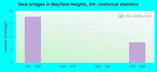
- New bridges - historical statistics
- 181960-1969
- 81990-1999

- Reconstructed bridges - Historical Statistics
- 21980-1989
- 41990-1999


- Bridge Condition - Deck
- 25.0%Very good
- 33.3%Good
- 41.7%Satisfactory

- Bridge Condition - Superstructure
- 58.3%Very good
- 41.7%Good

- Bridge Condition - Substructure
- 25.0%Very good
- 41.7%Good
- 33.3%Satisfactory
Find on map >> Show street view
Structure Number: 1811525, Location: 1.26 MI. S. OF JCT US-322 (Lat: 41.508919, Lng: -81.463289), Route carried "on" structure: County highway C0020, Year Built: 1963, Year Reconstructed: 1993, Status: Open, Structure Length: 13.14m (43.11ft), Average Daily Traffic: 13,032 (year 2015), Truck Traffic: 5%, Average Future Daily Traffic: 18,088 (year 2035), Design Load: H 20, Features Intersected: IR271&271X (LANDER), Facility Carried by Structure: LANDER RD
Minimum Vertical Clearance: 30+ m (98+ ft), Kilometerpoint: 1.609, Lanes on structure: 2, Lanes under structure: 6, Owner: State Highway Agency, Approaching Roadway Width: 11.9m (39.0ft), Skew: 2 degrees, Material/Design: Steel continuous, Design/Construction: Stringer/Multi-beam, Number Of Spans In Main Unit: 6, Length of Maximum Span: 24.4m (80.1ft), Curb or Sidewalk Widths: Left: 1.3m (4.3ft), Right: 1.3m (4.3ft), Curb-To-Curb Width: 8.5m (27.9ft), Out-to-Out Width: 11.8m (38.7ft)
Condition: Deck: Good, Superstructure: Good, Substructure: Good, Operating Rating: 42.1 metric tons, Method Used To Determine Operating Rating: Load Factor (LF) rating reported by rating factor (RF) method using MS18 loading, Inventory Rating: 32.4 metric tons, Method Used To Determine Inventory Rating: Load Factor (LF) rating reported by rating factor (RF) method using MS18 loading, Structural Evaluation: Better than present minimum criteria, Deck Geometry: Meets minimum limits, Underclear: High priority of corrective action, Approach Roadway Alignment: Equal to present desirable criteria, Designated Inspection Frequency: Every 24 months, Inspection Date: October 2021, Deck Structure Type: Concrete Cast-file-Place, Wearing Surface/Protective System: Wearing Surface: Low Slump Concrete
Find on map >> Show street view
Structure Number: 1811584, Location: .41 MI. S. OF JCT. US-322 (Lat: 41.515069, Lng: -81.449589), Route carried "on" structure: Interstate 271, Year Built: 1963, Year Reconstructed: 2001, Status: Open, Structure Length: 3.75m (12.30ft), Average Daily Traffic: 64,977 (year 2015), Truck Traffic: 9%, Average Future Daily Traffic: 90,188 (year 2035), Design Load: HS 20+Mod, Features Intersected: MARSOL RD @ MP 34.5
Minimum Vertical Clearance: 30+ m (98+ ft), Kilometerpoint: 20.503, Lanes on structure: 3, Lanes under structure: 2, Base Highway Network: Yes, Owner: State Highway Agency, Approaching Roadway Width: 17.7m (58.1ft), Skew: 3 degrees, Material/Design: Steel continuous, Design/Construction: Stringer/Multi-beam, Number Of Spans In Main Unit: 3, Length of Maximum Span: 14.6m (47.9ft), Curb-To-Curb Width: 18.3m (60.0ft), Out-to-Out Width: 19.2m (63.0ft)
Condition: Deck: Very good, Superstructure: Very good, Substructure: Very good, Operating Rating: 64.8 metric tons, Method Used To Determine Operating Rating: Load and Resistance Factor Rating (LRFR) rating reported by rating factor(RF) method using HL-93 loadings, Inventory Rating: 48.6 metric tons, Method Used To Determine Inventory Rating: Load and Resistance Factor Rating (LRFR) rating reported by rating factor(RF) method using HL-93 loadings, Structural Evaluation: Equal to present desirable criteria, Deck Geometry: Better than present minimum criteria, Underclear: Meets minimum limits, Approach Roadway Alignment: Equal to present desirable criteria, Designated Inspection Frequency: Every 24 months, Inspection Date: January 2021, Deck Structure Type: Concrete Cast-file-Place, Wearing Surface/Protective System: Wearing Surface: Monolithic Concrete, Deck Protection: Epoxy Coated Reinforcing
Find on map >> Show street view
Structure Number: 1811592, Location: 0.41 MI. S. OF JCT US 322 (Lat: 41.514861, Lng: -81.449350), Route carried "on" structure: Interstate 271X, Year Built: 1994, Status: Open, Structure Length: 3.75m (12.30ft), Average Daily Traffic: 64,977 (year 2015), Truck Traffic: 9%, Average Future Daily Traffic: 90,188 (year 2035), Design Load: HS 20+Mod, Features Intersected: MARSOL ROAD
Minimum Vertical Clearance: 30+ m (98+ ft), Kilometerpoint: 20.503, Lanes on structure: 2, Lanes under structure: 2, Base Highway Network: Yes, Owner: State Highway Agency, Approaching Roadway Width: 14.9m (48.9ft), Skew: 3 degrees, Material/Design: Steel continuous, Design/Construction: Stringer/Multi-beam, Number Of Spans In Main Unit: 3, Length of Maximum Span: 14.6m (47.9ft), Curb-To-Curb Width: 15.0m (49.2ft), Out-to-Out Width: 15.9m (52.2ft)
Condition: Deck: Good, Superstructure: Very good, Substructure: Good, Operating Rating: 42.1 metric tons, Method Used To Determine Operating Rating: Load Factor (LF) rating reported by rating factor (RF) method using MS18 loading, Inventory Rating: 32.4 metric tons, Method Used To Determine Inventory Rating: Load Factor (LF) rating reported by rating factor (RF) method using MS18 loading, Structural Evaluation: Better than present minimum criteria, Deck Geometry: Superior to present desirable criteria, Underclear: Meets minimum limits, Approach Roadway Alignment: Equal to present desirable criteria, Designated Inspection Frequency: Every 24 months, Inspection Date: January 2021, Deck Structure Type: Concrete Cast-file-Place, Wearing Surface/Protective System: Wearing Surface: Monolithic Concrete, Deck Protection: Epoxy Coated Reinforcing
Find on map >> Show street view
Structure Number: 1811606, Location: 0.41 MI. S. OF JCT US 322 (Lat: 41.514769, Lng: -81.449281), Route carried "on" structure: Interstate 271X, Year Built: 1994, Status: Open, Structure Length: 3.75m (12.30ft), Average Daily Traffic: 64,977 (year 2015), Truck Traffic: 9%, Average Future Daily Traffic: 90,188 (year 2035), Design Load: HS 20+Mod, Features Intersected: MARSOL ROAD
Minimum Vertical Clearance: 30+ m (98+ ft), Kilometerpoint: 20.503, Lanes on structure: 2, Lanes under structure: 2, Base Highway Network: Yes, Owner: State Highway Agency, Approaching Roadway Width: 14.9m (48.9ft), Skew: 3 degrees, Material/Design: Steel continuous, Design/Construction: Stringer/Multi-beam, Number Of Spans In Main Unit: 3, Length of Maximum Span: 14.6m (47.9ft), Curb-To-Curb Width: 15.0m (49.2ft), Out-to-Out Width: 15.9m (52.2ft)
Condition: Deck: Very good, Superstructure: Very good, Substructure: Very good, Operating Rating: 42.1 metric tons, Method Used To Determine Operating Rating: Load Factor (LF) rating reported by rating factor (RF) method using MS18 loading, Inventory Rating: 32.4 metric tons, Method Used To Determine Inventory Rating: Load Factor (LF) rating reported by rating factor (RF) method using MS18 loading, Structural Evaluation: Equal to present desirable criteria, Deck Geometry: Superior to present desirable criteria, Underclear: Meets minimum limits, Approach Roadway Alignment: Equal to present desirable criteria, Designated Inspection Frequency: Every 24 months, Inspection Date: January 2021, Deck Structure Type: Concrete Cast-file-Place, Wearing Surface/Protective System: Wearing Surface: Monolithic Concrete, Deck Protection: Epoxy Coated Reinforcing
Find on map >> Show street view
Structure Number: 1811614, Location: .41 MI. S. OF JCT. US-322 (Lat: 41.514711, Lng: -81.448889), Route carried "on" structure: Interstate 271, Year Built: 1963, Year Reconstructed: 2003, Status: Open, Structure Length: 3.75m (12.30ft), Average Daily Traffic: 64,977 (year 2015), Truck Traffic: 9%, Average Future Daily Traffic: 90,188 (year 2035), Design Load: HS 20+Mod, Features Intersected: MARSOL RD @ MP 34.5
Minimum Vertical Clearance: 30+ m (98+ ft), Kilometerpoint: 20.503, Lanes on structure: 3, Lanes under structure: 2, Base Highway Network: Yes, Owner: State Highway Agency, Approaching Roadway Width: 18.3m (60.0ft), Skew: 3 degrees, Material/Design: Steel continuous, Design/Construction: Stringer/Multi-beam, Number Of Spans In Main Unit: 3, Length of Maximum Span: 14.6m (47.9ft), Curb-To-Curb Width: 18.3m (60.0ft), Out-to-Out Width: 19.2m (63.0ft)
Condition: Deck: Very good, Superstructure: Very good, Substructure: Good, Operating Rating: 58.3 metric tons, Method Used To Determine Operating Rating: Load and Resistance Factor Rating (LRFR) rating reported by rating factor(RF) method using HL-93 loadings, Inventory Rating: 45.4 metric tons, Method Used To Determine Inventory Rating: Load and Resistance Factor Rating (LRFR) rating reported by rating factor(RF) method using HL-93 loadings, Structural Evaluation: Better than present minimum criteria, Deck Geometry: Better than present minimum criteria, Underclear: Meets minimum limits, Approach Roadway Alignment: Equal to present desirable criteria, Designated Inspection Frequency: Every 24 months, Inspection Date: January 2021, Deck Structure Type: Concrete Cast-file-Place, Wearing Surface/Protective System: Wearing Surface: Monolithic Concrete, Deck Protection: Epoxy Coated Reinforcing
Find on map >> Show street view
Structure Number: 1811649, Location: JCT. US-322 WITH I-27 (Lat: 41.519800, Lng: -81.445781), Route carried "on" structure: Ramp Interstate 271, Year Built: 1961, Status: Open, Structure Length: 7.19m (23.59ft), Average Daily Traffic: 39,660 (year 1988), Truck Traffic: 8%, Average Future Daily Traffic: 55,048 (year 2008), Design Load: HS 20+Mod, Features Intersected: USR 322 (1340) @ MP 34.9
Minimum Vertical Clearance: 30+ m (98+ ft), Kilometerpoint: 21.163, Lanes on structure: 2, Lanes under structure: 6, Owner: State Highway Agency, Approaching Roadway Width: 11.6m (38.1ft), Skew: 1 degrees, Material/Design: Steel continuous, Design/Construction: Stringer/Multi-beam, Number Of Spans In Main Unit: 4, Length of Maximum Span: 19.8m (65.0ft), Curb-To-Curb Width: 11.6m (38.1ft), Out-to-Out Width: 12.3m (40.4ft)
Condition: Deck: Satisfactory, Superstructure: Good, Substructure: Satisfactory, Operating Rating: 42.1 metric tons, Method Used To Determine Operating Rating: Allowable Stress (AS) rating reported by rating factor (RF) method using MS18 loading, Inventory Rating: 32.4 metric tons, Method Used To Determine Inventory Rating: Allowable Stress (AS) rating reported by rating factor (RF) method using MS18 loading, Structural Evaluation: Equal to present minimum criteria, Deck Geometry: Superior to present desirable criteria, Underclear: Meets minimum limits, Approach Roadway Alignment: Equal to present desirable criteria, Designated Inspection Frequency: Every 12 months, Inspection Date: January 2021, Deck Structure Type: Concrete Cast-file-Place, Wearing Surface/Protective System: Wearing Surface: Low Slump Concrete
Find on map >> Show street view
Structure Number: 1811673, Location: JCT. US-322 WITH I-271 (Lat: 41.519769, Lng: -81.445581), Route carried "on" structure: Interstate 271, Year Built: 1963, Year Reconstructed: 2001, Status: Open, Structure Length: 7.19m (23.59ft), Average Daily Traffic: 49,428 (year 2015), Truck Traffic: 9%, Average Future Daily Traffic: 68,606 (year 2035), Design Load: HS 20+Mod, Features Intersected: USR 322 (1341) @ MP 34.9
Minimum Vertical Clearance: 30+ m (98+ ft), Kilometerpoint: 21.163, Lanes on structure: 2, Lanes under structure: 6, Base Highway Network: Yes, Owner: State Highway Agency, Approaching Roadway Width: 11.6m (38.1ft), Skew: 1 degrees, Material/Design: Steel continuous, Design/Construction: Stringer/Multi-beam, Number Of Spans In Main Unit: 4, Length of Maximum Span: 19.8m (65.0ft), Curb-To-Curb Width: 12.2m (40.0ft), Out-to-Out Width: 13.3m (43.6ft)
Condition: Deck: Satisfactory, Superstructure: Very good, Substructure: Satisfactory, Operating Rating: 42.1 metric tons, Method Used To Determine Operating Rating: Allowable Stress (AS) rating reported by rating factor (RF) method using MS18 loading, Inventory Rating: 32.4 metric tons, Method Used To Determine Inventory Rating: Allowable Stress (AS) rating reported by rating factor (RF) method using MS18 loading, Structural Evaluation: Equal to present minimum criteria, Deck Geometry: Better than present minimum criteria, Underclear: Meets minimum limits, Approach Roadway Alignment: Equal to present desirable criteria, Designated Inspection Frequency: Every 12 months, Inspection Date: January 2021, Deck Structure Type: Concrete Cast-file-Place, Wearing Surface/Protective System: Wearing Surface: Monolithic Concrete, Deck Protection: Epoxy Coated Reinforcing
Find on map >> Show street view
Structure Number: 1811681, Location: 3.5 MI S. OF CUY/LAK LINE (Lat: 41.519789, Lng: -81.445269), Route carried "on" structure: Interstate 271X, Year Built: 1994, Status: Open, Structure Length: 7.19m (23.59ft), Average Daily Traffic: 49,428 (year 2015), Truck Traffic: 9%, Average Future Daily Traffic: 68,606 (year 2035), Design Load: HS 20+Mod, Features Intersected: USR 322 (MAYFIELD RD)
Minimum Vertical Clearance: 30+ m (98+ ft), Kilometerpoint: 21.163, Lanes on structure: 2, Lanes under structure: 4, Base Highway Network: Yes, Owner: State Highway Agency, Approaching Roadway Width: 14.9m (48.9ft), Skew: 1 degrees, Material/Design: Steel continuous, Design/Construction: Stringer/Multi-beam, Number Of Spans In Main Unit: 4, Length of Maximum Span: 19.8m (65.0ft), Curb-To-Curb Width: 15.0m (49.2ft), Out-to-Out Width: 15.9m (52.2ft)
Condition: Deck: Good, Superstructure: Very good, Substructure: Good, Operating Rating: 42.1 metric tons, Method Used To Determine Operating Rating: Load Factor (LF) rating reported by rating factor (RF) method using MS18 loading, Inventory Rating: 32.4 metric tons, Method Used To Determine Inventory Rating: Load Factor (LF) rating reported by rating factor (RF) method using MS18 loading, Structural Evaluation: Better than present minimum criteria, Deck Geometry: Superior to present desirable criteria, Underclear: Meets minimum limits, Approach Roadway Alignment: Equal to present desirable criteria, Designated Inspection Frequency: Every 24 months, Inspection Date: January 2021, Deck Structure Type: Concrete Cast-file-Place, Wearing Surface/Protective System: Wearing Surface: Monolithic Concrete, Deck Protection: Epoxy Coated Reinforcing
Find on map >> Show street view
Structure Number: 1811703, Location: JCT. US-322 WITH I-271 (Lat: 41.519789, Lng: -81.444781), Route carried "on" structure: Interstate 271, Year Built: 1963, Year Reconstructed: 2001, Status: Open, Structure Length: 7.19m (23.59ft), Average Daily Traffic: 49,428 (year 2015), Truck Traffic: 9%, Average Future Daily Traffic: 68,606 (year 2035), Design Load: HS 20+Mod, Features Intersected: USR 322 (1345) @ MP 34.9
Minimum Vertical Clearance: 30+ m (98+ ft), Kilometerpoint: 21.163, Lanes on structure: 2, Lanes under structure: 6, Base Highway Network: Yes, Owner: State Highway Agency, Approaching Roadway Width: 11.6m (38.1ft), Skew: 1 degrees, Material/Design: Steel continuous, Design/Construction: Stringer/Multi-beam, Number Of Spans In Main Unit: 4, Length of Maximum Span: 19.8m (65.0ft), Curb-To-Curb Width: 12.2m (40.0ft), Out-to-Out Width: 13.3m (43.6ft)
Condition: Deck: Satisfactory, Superstructure: Good, Substructure: Satisfactory, Operating Rating: 42.1 metric tons, Method Used To Determine Operating Rating: Allowable Stress (AS) rating reported by rating factor (RF) method using MS18 loading, Inventory Rating: 32.4 metric tons, Method Used To Determine Inventory Rating: Allowable Stress (AS) rating reported by rating factor (RF) method using MS18 loading, Structural Evaluation: Equal to present minimum criteria, Deck Geometry: Better than present minimum criteria, Underclear: Meets minimum limits, Approach Roadway Alignment: Equal to present desirable criteria, Designated Inspection Frequency: Every 12 months, Inspection Date: January 2021, Deck Structure Type: Concrete Cast-file-Place, Wearing Surface/Protective System: Wearing Surface: Monolithic Concrete, Deck Protection: Epoxy Coated Reinforcing
Find on map >> Show street view
Structure Number: 1811711, Location: 3.5 MI S. OF CUY/LAK LINE (Lat: 41.519789, Lng: -81.445061), Route carried "on" structure: Interstate 271X, Year Built: 1994, Status: Open, Structure Length: 7.19m (23.59ft), Average Daily Traffic: 49,428 (year 2015), Truck Traffic: 9%, Average Future Daily Traffic: 68,606 (year 2035), Design Load: HS 20+Mod, Features Intersected: USR 322 (MAYFIELD RD)
Minimum Vertical Clearance: 30+ m (98+ ft), Kilometerpoint: 21.163, Lanes on structure: 2, Lanes under structure: 4, Base Highway Network: Yes, Owner: State Highway Agency, Approaching Roadway Width: 14.9m (48.9ft), Skew: 1 degrees, Material/Design: Steel continuous, Design/Construction: Stringer/Multi-beam, Number Of Spans In Main Unit: 4, Length of Maximum Span: 19.8m (65.0ft), Curb-To-Curb Width: 15.0m (49.2ft), Out-to-Out Width: 15.9m (52.2ft)
Condition: Deck: Satisfactory, Superstructure: Very good, Substructure: Very good, Operating Rating: 42.1 metric tons, Method Used To Determine Operating Rating: Load Factor (LF) rating reported by rating factor (RF) method using MS18 loading, Inventory Rating: 32.4 metric tons, Method Used To Determine Inventory Rating: Load Factor (LF) rating reported by rating factor (RF) method using MS18 loading, Structural Evaluation: Equal to present desirable criteria, Deck Geometry: Superior to present desirable criteria, Underclear: Meets minimum limits, Approach Roadway Alignment: Equal to present desirable criteria, Designated Inspection Frequency: Every 12 months, Inspection Date: January 2021, Deck Structure Type: Concrete Cast-file-Place, Wearing Surface/Protective System: Wearing Surface: Monolithic Concrete, Deck Protection: Epoxy Coated Reinforcing
Find on map >> Show street view
Structure Number: 1811738, Location: JCT. US-322 WITH I-271 (Lat: 41.519789, Lng: -81.444539), Route carried "on" structure: Ramp Interstate 271, Year Built: 1961, Status: Open, Structure Length: 7.19m (23.59ft), Average Daily Traffic: 39,660 (year 1988), Truck Traffic: 8%, Average Future Daily Traffic: 55,048 (year 2008), Design Load: HS 20+Mod, Features Intersected: USR 322 (1346) @ MP 34.9
Minimum Vertical Clearance: 30+ m (98+ ft), Kilometerpoint: 21.163, Lanes on structure: 2, Lanes under structure: 6, Owner: State Highway Agency, Approaching Roadway Width: 11.6m (38.1ft), Skew: 1 degrees, Material/Design: Steel continuous, Design/Construction: Stringer/Multi-beam, Number Of Spans In Main Unit: 4, Length of Maximum Span: 19.8m (65.0ft), Curb-To-Curb Width: 11.6m (38.1ft), Out-to-Out Width: 12.3m (40.4ft)
Condition: Deck: Satisfactory, Superstructure: Good, Substructure: Satisfactory, Operating Rating: 42.1 metric tons, Method Used To Determine Operating Rating: Allowable Stress (AS) rating reported by rating factor (RF) method using MS18 loading, Inventory Rating: 32.4 metric tons, Method Used To Determine Inventory Rating: Allowable Stress (AS) rating reported by rating factor (RF) method using MS18 loading, Structural Evaluation: Equal to present minimum criteria, Deck Geometry: Superior to present desirable criteria, Underclear: Meets minimum limits, Approach Roadway Alignment: Equal to present desirable criteria, Designated Inspection Frequency: Every 12 months, Inspection Date: January 2021, Deck Structure Type: Concrete Cast-file-Place, Wearing Surface/Protective System: Wearing Surface: Low Slump Concrete
Find on map >> Show street view
Structure Number: 1811762, Location: .75 MI. N. OF JCT. US-322 (Lat: 41.530461, Lng: -81.447269), Route carried "on" structure: County highway C0054, Year Built: 1963, Year Reconstructed: 1994, Status: Open, Structure Length: 12.25m (40.19ft), Average Daily Traffic: 9,462 (year 2015), Truck Traffic: 5%, Average Future Daily Traffic: 13,133 (year 2035), Design Load: H 15, Features Intersected: IR271&271X (RIDGEBURY), Facility Carried by Structure: RIDGEBURY BLVD.
Minimum Vertical Clearance: 30+ m (98+ ft), Kilometerpoint: 1.609, Lanes on structure: 2, Lanes under structure: 6, Owner: State Highway Agency, Approaching Roadway Width: 11.3m (37.1ft), Skew: 1 degrees, Material/Design: Steel continuous, Design/Construction: Stringer/Multi-beam, Number Of Spans In Main Unit: 6, Length of Maximum Span: 22.9m (75.1ft), Curb or Sidewalk Widths: Left: 1.3m (4.3ft), Right: 1.3m (4.3ft), Curb-To-Curb Width: 8.5m (27.9ft), Out-to-Out Width: 11.8m (38.7ft)
Condition: Deck: Good, Superstructure: Good, Substructure: Good, Operating Rating: 42.1 metric tons, Method Used To Determine Operating Rating: Load Factor (LF) rating reported by rating factor (RF) method using MS18 loading, Inventory Rating: 32.4 metric tons, Method Used To Determine Inventory Rating: Load Factor (LF) rating reported by rating factor (RF) method using MS18 loading, Structural Evaluation: Better than present minimum criteria, Deck Geometry: Meets minimum limits, Underclear: High priority of corrective action, Approach Roadway Alignment: Equal to present desirable criteria, Designated Inspection Frequency: Every 24 months, Inspection Date: January 2021, Deck Structure Type: Concrete Cast-file-Place, Wearing Surface/Protective System: Wearing Surface: Monolithic Concrete, Deck Protection: Epoxy Coated Reinforcing
Find on map >> Show street view
Structure Number: 1811525, Location: 1.26 MI. S. OF JCT US-322 (Lat: 41.508919, Lng: -81.463289), Route carried "under" structure: Interstate 271, Year Built: 1963, Structure Length: 0. m, Average Daily Traffic: 129,954 (year 2015), Truck Traffic: 9%, Features Intersected: CR-20 (Lander Rd), Facility Carried by Structure: LANDER RD
Minimum Vertical Clearance: 5.04m (16.54ft), Kilometerpoint: 19.135, Lanes on structure: 2, Lanes under structure: 6, Material/Design: Steel continuous, Design/Construction: Stringer/Multi-beam, Length of Maximum Span: 24.4m (80.1ft)
Find on map >> Show street view
Structure Number: 1811525, Location: 1.26 MI. S. OF JCT US-322 (Lat: 41.508919, Lng: -81.463289), Route carried "under" structure: Interstate 271X, Year Built: 1963, Structure Length: 0. m, Average Daily Traffic: 113,670 (year 2010), Truck Traffic: 11%, Features Intersected: CR-20 (Lander Rd), Facility Carried by Structure: LANDER RD
Minimum Vertical Clearance: 5.39m (17.68ft), Kilometerpoint: 19.135, Lanes on structure: 2, Lanes under structure: 6, Material/Design: Steel continuous, Design/Construction: Stringer/Multi-beam, Length of Maximum Span: 24.4m (80.1ft)
Find on map >> Show street view
Structure Number: 1811584, Location: .41 MI. S. OF JCT. US-322 (Lat: 41.515069, Lng: -81.449589), Route carried "under" structure: City street MSLRD, Year Built: 1963, Structure Length: 0. m, Average Daily Traffic: 100 (year 1970), Features Intersected: I-271, Facility Carried by Structure: IR 271 S.B
Minimum Vertical Clearance: 4.29m (14.07ft), Kilometerpoint: 0.000, Lanes on structure: 3, Lanes under structure: 2, Material/Design: Steel continuous, Design/Construction: Stringer/Multi-beam, Length of Maximum Span: 14.6m (47.9ft)
Find on map >> Show street view
Structure Number: 1811592, Location: 0.41 MI. S. OF JCT US 322 (Lat: 41.514861, Lng: -81.449350), Route carried "under" structure: City street MSLRD, Year Built: 1994, Structure Length: 0. m, Average Daily Traffic: 100 (year 1970), Features Intersected: IR-271X, Facility Carried by Structure: IR 271X SB
Minimum Vertical Clearance: 4.42m (14.50ft), Kilometerpoint: 0.000, Lanes on structure: 2, Lanes under structure: 2, Material/Design: Steel continuous, Design/Construction: Stringer/Multi-beam, Length of Maximum Span: 14.6m (47.9ft)
Find on map >> Show street view
Structure Number: 1811606, Location: 0.41 MI. S. OF JCT US 322 (Lat: 41.514769, Lng: -81.449281), Route carried "under" structure: City street MSLRD, Year Built: 1994, Structure Length: 0. m, Average Daily Traffic: 100 (year 1970), Features Intersected: IR-271X, Facility Carried by Structure: IR 271X NB
Minimum Vertical Clearance: 4.93m (16.17ft), Kilometerpoint: 0.000, Lanes on structure: 2, Lanes under structure: 2, Material/Design: Steel continuous, Design/Construction: Stringer/Multi-beam, Length of Maximum Span: 14.6m (47.9ft)
Find on map >> Show street view
Structure Number: 1811614, Location: .41 MI. S. OF JCT. US-322 (Lat: 41.514711, Lng: -81.448889), Route carried "under" structure: City street MSLRD, Year Built: 1963, Structure Length: 0. m, Average Daily Traffic: 100 (year 1970), Features Intersected: I-271, Facility Carried by Structure: IR 271 N.B.
Minimum Vertical Clearance: 4.32m (14.17ft), Kilometerpoint: 0.000, Lanes on structure: 3, Lanes under structure: 2, Material/Design: Steel continuous, Design/Construction: Stringer/Multi-beam, Length of Maximum Span: 14.6m (47.9ft)
Find on map >> Show street view
Structure Number: 1811649, Location: JCT. US-322 WITH I-27 (Lat: 41.519800, Lng: -81.445781), Route carried "under" structure: US 322, Year Built: 1961, Structure Length: 0. m, Average Daily Traffic: 26,582 (year 2010), Truck Traffic: 3%, Features Intersected: I-271 SB RAMP (1315W), Facility Carried by Structure: RAMP WEST OF I-271
Minimum Vertical Clearance: 4.74m (15.55ft), Kilometerpoint: 21.565, Lanes on structure: 2, Lanes under structure: 6, Material/Design: Steel continuous, Design/Construction: Stringer/Multi-beam, Length of Maximum Span: 19.8m (65.0ft)
Find on map >> Show street view
Structure Number: 1811673, Location: JCT. US-322 WITH I-271 (Lat: 41.519769, Lng: -81.445581), Route carried "under" structure: US 322, Year Built: 1963, Structure Length: 0. m, Average Daily Traffic: 26,582 (year 2010), Truck Traffic: 3%, Features Intersected: I-271 SB (CUY-271-1315L), Facility Carried by Structure: IR 271 S.B
Minimum Vertical Clearance: 4.93m (16.17ft), Kilometerpoint: 21.581, Lanes on structure: 2, Lanes under structure: 6, Material/Design: Steel continuous, Design/Construction: Stringer/Multi-beam, Length of Maximum Span: 19.8m (65.0ft)
Find on map >> Show street view
Structure Number: 1811681, Location: 3.5 MI S. OF CUY/LAK LINE (Lat: 41.519789, Lng: -81.445269), Route carried "under" structure: US 322, Year Built: 1994, Structure Length: 0. m, Average Daily Traffic: 26,582 (year 2010), Truck Traffic: 3%, Features Intersected: IR-271X, Facility Carried by Structure: IR 271X SB
Minimum Vertical Clearance: 5.36m (17.59ft), Kilometerpoint: 21.597, Lanes on structure: 2, Lanes under structure: 4, Material/Design: Steel continuous, Design/Construction: Stringer/Multi-beam, Length of Maximum Span: 19.8m (65.0ft)
Find on map >> Show street view
Structure Number: 1811703, Location: JCT. US-322 WITH I-271 (Lat: 41.519789, Lng: -81.444781), Route carried "under" structure: US 322, Year Built: 1963, Structure Length: 0. m, Average Daily Traffic: 26,582 (year 2010), Truck Traffic: 3%, Features Intersected: I-271 NB (CUY-271-1315R), Facility Carried by Structure: IR 271 N.B
Minimum Vertical Clearance: 6.22m (20.41ft), Kilometerpoint: 21.646, Lanes on structure: 2, Lanes under structure: 6, Material/Design: Steel continuous, Design/Construction: Stringer/Multi-beam, Length of Maximum Span: 19.8m (65.0ft)
Find on map >> Show street view
Structure Number: 1811711, Location: 3.5 MI S. OF CUY/LAK LINE (Lat: 41.519789, Lng: -81.445061), Route carried "under" structure: US 322, Year Built: 1994, Structure Length: 0. m, Average Daily Traffic: 26,582 (year 2010), Truck Traffic: 3%, Features Intersected: IR-271X, Facility Carried by Structure: IR 271X NB
Minimum Vertical Clearance: 5.74m (18.83ft), Kilometerpoint: 21.613, Lanes on structure: 2, Lanes under structure: 4, Material/Design: Steel continuous, Design/Construction: Stringer/Multi-beam, Length of Maximum Span: 19.8m (65.0ft)
Find on map >> Show street view
Structure Number: 1811738, Location: JCT. US-322 WITH I-271 (Lat: 41.519789, Lng: -81.444539), Route carried "under" structure: US 322, Year Built: 1961, Structure Length: 0. m, Average Daily Traffic: 28,120 (year 2010), Truck Traffic: 4%, Features Intersected: I-271 NB RAMP (1315E), Facility Carried by Structure: RAMP EAST OF I-271
Minimum Vertical Clearance: 6.81m (22.34ft), Kilometerpoint: 21.662, Lanes on structure: 2, Lanes under structure: 6, Material/Design: Steel continuous, Design/Construction: Stringer/Multi-beam, Length of Maximum Span: 19.8m (65.0ft)
Find on map >> Show street view
Structure Number: 1811762, Location: .75 MI. N. OF JCT. US-322 (Lat: 41.530461, Lng: -81.447269), Route carried "under" structure: Interstate 271X, Year Built: 1963, Structure Length: 0. m, Average Daily Traffic: 107,380 (year 2010), Truck Traffic: 11%, Features Intersected: CR-54 (Ridgebury Blvd.), Facility Carried by Structure: RIDGEBURY BLVD.
Minimum Vertical Clearance: 5.23m (17.16ft), Kilometerpoint: 22.370, Lanes on structure: 2, Lanes under structure: 6, Material/Design: Steel continuous, Design/Construction: Stringer/Multi-beam, Length of Maximum Span: 22.9m (75.1ft)
Find on map >> Show street view
Structure Number: 1811762, Location: .75 MI. N. OF JCT. US-322 (Lat: 41.530461, Lng: -81.447269), Route carried "under" structure: Interstate 271, Year Built: 1963, Structure Length: 0. m, Average Daily Traffic: 107,380 (year 2010), Truck Traffic: 11%, Features Intersected: CR-54 (Ridgebury Blvd), Facility Carried by Structure: RIDGEBURY BLVD.
Minimum Vertical Clearance: 4.90m (16.08ft), Kilometerpoint: 22.370, Lanes on structure: 2, Lanes under structure: 6, Material/Design: Steel continuous, Design/Construction: Stringer/Multi-beam, Length of Maximum Span: 22.9m (75.1ft)