Bridge Statistics for Maytown, Pennsylvania (PA)
Condition, Traffic, Stress, Structural Evaluation, Project Costs
- National Bridge Inventory (NBI) Statistics
- 19Number of bridges
- 102ft / 31.1mTotal length
- $3,268,000Total costs
- 55,527Total average daily traffic
- 9,207Total average daily truck traffic
- 77,540Total future (year 2011) average daily traffic
- National Bridge Inventory (NBI) Registered Bridges for Maytown
- No street view available for this location
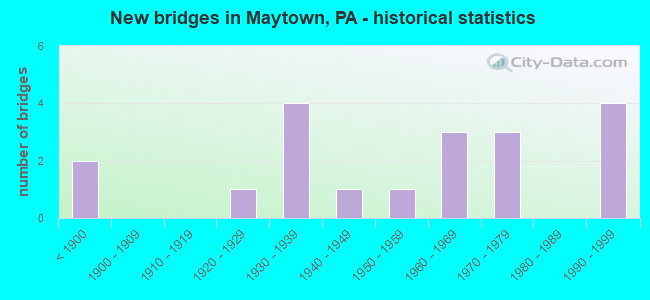
- New bridges - historical statistics
- 2Before 1900
- 11920-1929
- 41930-1939
- 11940-1949
- 11950-1959
- 31960-1969
- 31970-1979
- 41990-1999

- Reconstructed bridges - Historical Statistics
- 21940-1949
- 11950-1959
- 01960-1969
- 11970-1979
- 01980-1989
- 11990-1999
- 22000-2009


- Bridge Condition - Deck
- 14.3%Very good
- 7.1%Good
- 42.9%Satisfactory
- 21.4%Fair
- 14.3%Poor

- Bridge Condition - Superstructure
- 6.7%Excellent
- 20.0%Good
- 26.7%Satisfactory
- 26.7%Fair
- 20.0%Poor

- Bridge Condition - Substructure
- 26.7%Good
- 13.3%Satisfactory
- 20.0%Fair
- 33.3%Poor
- 6.7%Serious

- Bridge Condition - Channel
- 22.2%Good
- 16.7%Satisfactory
- 33.3%Fair
- 27.8%Poor

- Bridge Condition - Culverts
- 75.0%Good
- 25.0%Satisfactory
Find on map >> Show street view
Structure Number: 7583, Location: CREAMERY IRON BRG.2582-D8 (Lat: 40.516100, Lng: -75.292356), Route carried "on" structure: City street , Year Built: 1882, Year Reconstructed: 1950, Status: Posted for load, Structure Length: 1.68m (5.51ft), Average Daily Traffic: 250 (year 1998), Average Future Daily Traffic: 840 (year 2011), Features Intersected: COOKS CREEK, Facility Carried by Structure: BRIDGE STREET
Minimum Vertical Clearance: 1.98m (6.50ft), Kilometerpoint: 0.000, Lanes on structure: 1, Owner: County Highway Agency, Approaching Roadway Width: 5.5m (18.0ft), Skew: 2 degrees, Material/Design: Steel, Design/Construction: Truss - Thru, Number Of Spans In Main Unit: 1, Length of Maximum Span: 16.2m (53.1ft), Curb-To-Curb Width: 4.3m (14.1ft), Out-to-Out Width: 4.9m (16.1ft)
Condition: Deck: Very good, Superstructure: Good, Substructure: Good, Channel: Fair, Operating Rating: 15.4 metric tons, Method Used To Determine Operating Rating: Allowable Stress (AS), Inventory Rating: 10.9 metric tons, Method Used To Determine Inventory Rating: Allowable Stress (AS), Structural Evaluation: Meets minimum limits, Deck Geometry: High priority of replacement, Waterway Adequacy: Equal to present minimum criteria, Approach Roadway Alignment: Somewhat better than minimum adequacy, Bridge Posting: Required (Relationship of Operating Rating to Maximum Legal Load: > 39.9% below), Length Of Structure Improvement: 2.00m (6.56ft), Designated Inspection Frequency: Every 24 months, Critical Feature Inspection Frequency: Every 12 months, Other Special Inspection Frequency: Every 12 months, Inspection Date: August 2020, Critical Feature Inspection Date: August 2021, Other Special Inspection Date: August 2021, Bridge Improvement Cost: $39,000, Roadway Improvement Cost: $116,000, Total Project Cost: $531,000, Deck Structure Type: Open Grating
Find on map >> Show street view
Structure Number: 8676, Location: 1 MI.W.OF ST.MICHAEL (Lat: 40.346286, Lng: -78.783228), Route carried "on" structure: State highway , Year Built: 1965, Status: Open, Structure Length: 1.16m (3.81ft), Average Daily Traffic: 1,933 (year 2021), Truck Traffic: 6%, Average Future Daily Traffic: 2,641 (year 2032), Design Load: H 20, Features Intersected: SANDY RUN, Facility Carried by Structure: SR 3048 WAS SR 869
Minimum Vertical Clearance: 30+ m (98+ ft), Kilometerpoint: 0.000, Lanes on structure: 2, Owner: State Highway Agency, Approaching Roadway Width: 11.0m (36.1ft), Skew: 1 degrees, Material/Design: Concrete, Design/Construction: Culvert, Number Of Spans In Main Unit: 2, Length of Maximum Span: 5.5m (18.0ft)
Condition: Channel: Satisfactory, Culverts: Good, Operating Rating: 72.6 metric tons, Method Used To Determine Operating Rating: Load Factor (LF), Inventory Rating: 43.5 metric tons, Method Used To Determine Inventory Rating: Load Factor (LF), Structural Evaluation: Better than present minimum criteria, Waterway Adequacy: Equal to present desirable criteria, Approach Roadway Alignment: Equal to present desirable criteria, Length Of Structure Improvement: 1.80m (5.91ft), Designated Inspection Frequency: Every 24 months, Inspection Date: January 2021
Find on map >> Show street view
Structure Number: 8677, Location: 1 MI.W.OF SAINT MICHAEL (Lat: 40.347100, Lng: -78.783703), Route carried "on" structure: State highway , Year Built: 1977, Status: Open, Structure Length: 1.10m (3.61ft), Average Daily Traffic: 2,081 (year 2021), Truck Traffic: 6%, Average Future Daily Traffic: 2,573 (year 2032), Design Load: HS 20, Features Intersected: SANDY RUN, Facility Carried by Structure: SR 3048 WAS SR 869
Minimum Vertical Clearance: 30+ m (98+ ft), Kilometerpoint: 0.000, Lanes on structure: 2, Owner: State Highway Agency, Approaching Roadway Width: 9.8m (32.2ft), Skew: 1 degrees, Material/Design: Steel, Design/Construction: Culvert, Number Of Spans In Main Unit: 2, Length of Maximum Span: 5.2m (17.1ft)
Condition: Channel: Fair, Culverts: Satisfactory, Operating Rating: 89.8 metric tons, Method Used To Determine Operating Rating: Allowable Stress (AS), Inventory Rating: 88.9 metric tons, Method Used To Determine Inventory Rating: Allowable Stress (AS), Structural Evaluation: Equal to present minimum criteria, Waterway Adequacy: Equal to present desirable criteria, Approach Roadway Alignment: Equal to present desirable criteria, Length Of Structure Improvement: 1.70m (5.58ft), Designated Inspection Frequency: Every 48 months, Inspection Date: Febuary 2019
Find on map >> Show street view
Structure Number: 9905, Location: NEAR AVONDALE 46D4/3800E5 (Lat: 39.845242, Lng: -75.786083), Route carried "on" structure: US 1, Year Built: 1965, Status: Open, Structure Length: 1.19m (3.90ft), Average Daily Traffic: 16,463 (year 2020), Truck Traffic: 11%, Average Future Daily Traffic: 18,602 (year 2032), Design Load: HS 20, Features Intersected: E.FRK BR. WHITE CLAY CR
Minimum Vertical Clearance: 30+ m (98+ ft), Kilometerpoint: 27.856, Lanes on structure: 2, Base Highway Network: Yes, Owner: State Highway Agency, Approaching Roadway Width: 12.2m (40.0ft), Skew: 12 degrees, Material/Design: Prestressed concrete, Design/Construction: Box Beam or Girders - Single/Spread, Number Of Spans In Main Unit: 1, Length of Maximum Span: 11.3m (37.1ft), Curb or Sidewalk Widths: Left: 0.2m (0.7ft), Right: 0.2m (0.7ft), Curb-To-Curb Width: 12.2m (40.0ft), Out-to-Out Width: 13.1m (43.0ft)
Condition: Deck: Satisfactory, Superstructure: Satisfactory, Substructure: Good, Channel: Poor, Operating Rating: 66.2 metric tons, Method Used To Determine Operating Rating: Load Factor (LF), Inventory Rating: 39.0 metric tons, Method Used To Determine Inventory Rating: Load Factor (LF), Structural Evaluation: Equal to present minimum criteria, Deck Geometry: Better than present minimum criteria, Waterway Adequacy: Superior to present desirable criteria, Approach Roadway Alignment: Equal to present desirable criteria, Length Of Structure Improvement: 1.80m (5.91ft), Designated Inspection Frequency: Every 24 months, Inspection Date: June 2020, Deck Structure Type: Concrete Cast-file-Place, Wearing Surface/Protective System: Wearing Surface: Monolithic Concrete
Find on map >> Show street view
Structure Number: 21677, Location: DONEGAL SPRINGS (Lat: 40.100867, Lng: -76.561039), Route carried "on" structure: State highway , Year Built: 1995, Status: Open, Structure Length: 0.88m (2.89ft), Average Daily Traffic: 1,432 (year 2022), Truck Traffic: 3%, Average Future Daily Traffic: 1,946 (year 2032), Design Load: HS 25 or greater, Features Intersected: DONEGAL CREEK, Facility Carried by Structure: SR 4002; TWP RD
Minimum Vertical Clearance: 30+ m (98+ ft), Kilometerpoint: 2.865, Lanes on structure: 2, Owner: State Highway Agency, Approaching Roadway Width: 9.8m (32.2ft), Skew: 1 degrees, Material/Design: Concrete, Design/Construction: Culvert, Number Of Spans In Main Unit: 2, Length of Maximum Span: 3.7m (12.1ft), Curb-To-Curb Width: 9.8m (32.2ft), Out-to-Out Width: 11.0m (36.1ft)
Condition: Channel: Good, Culverts: Good, Operating Rating: 74.4 metric tons, Method Used To Determine Operating Rating: Load Factor (LF), Inventory Rating: 44.5 metric tons, Method Used To Determine Inventory Rating: Load Factor (LF), Structural Evaluation: Better than present minimum criteria, Deck Geometry: Somewhat better than minimum adequacy, Waterway Adequacy: Better than present minimum criteria, Approach Roadway Alignment: Equal to present desirable criteria, Length Of Structure Improvement: 1.40m (4.59ft), Designated Inspection Frequency: Every 24 months, Inspection Date: May 2021, Wearing Surface/Protective System: Wearing Surface: Bituminous, Membrane: Preformed Fabric, Deck Protection: Epoxy Coated Reinforcing
Find on map >> Show street view
Structure Number: 21901, Location: 2000 FT WEST OF SR 4017 (Lat: 40.085883, Lng: -76.539769), Route carried "on" structure: City street , Year Built: 1973, Year Reconstructed: 2012, Status: Open, Structure Length: 1.01m (3.31ft), Average Daily Traffic: 200 (year 2012), Truck Traffic: 3%, Average Future Daily Traffic: 270 (year 2032), Design Load: HS 20, Features Intersected: DONEGAL CREEK, Facility Carried by Structure: T-809 TROUT RUN RD
Minimum Vertical Clearance: 30+ m (98+ ft), Kilometerpoint: 0.000, Lanes on structure: 2, Owner: Town or Township Highway Agency, Approaching Roadway Width: 6.1m (20.0ft), Material/Design: Prestressed concrete, Design/Construction: Box Beam or Girders - Multiple, Number Of Spans In Main Unit: 1, Length of Maximum Span: 9.8m (32.2ft), Curb or Sidewalk Widths: Left: 0.2m (0.7ft), Right: 0.2m (0.7ft), Curb-To-Curb Width: 6.6m (21.7ft), Out-to-Out Width: 7.8m (25.6ft)
Condition: Deck: Good, Superstructure: Excellent, Substructure: Satisfactory, Channel: Satisfactory, Operating Rating: 70.8 metric tons, Method Used To Determine Operating Rating: Load and Resistance Factor (LRFR), Inventory Rating: 54.4 metric tons, Method Used To Determine Inventory Rating: Load and Resistance Factor (LRFR), Structural Evaluation: Equal to present minimum criteria, Deck Geometry: Meets minimum limits, Waterway Adequacy: Superior to present desirable criteria, Approach Roadway Alignment: Somewhat better than minimum adequacy, Length Of Structure Improvement: 1.00m (3.28ft), Designated Inspection Frequency: Every 24 months, Underwater Inspection Frequency: Every 60 months, Inspection Date: September 2021, Underwater Inspection Date: November 2017, Deck Structure Type: Concrete Cast-file-Place, Wearing Surface/Protective System: Wearing Surface: Monolithic Concrete, Deck Protection: Epoxy Coated Reinforcing
Find on map >> Show street view
Structure Number: 21903, Location: 1/2 MI NE OF SR 4046 (Lat: 40.092567, Lng: -76.547631), Route carried "on" structure: City street , Year Built: 1930, Status: Open, Structure Length: 1.25m (4.10ft), Average Daily Traffic: 310 (year 2011), Truck Traffic: 1%, Average Future Daily Traffic: 415 (year 2031), Features Intersected: W BR DONEGAL CREEK, Facility Carried by Structure: KRAYBILL CHURCH RD
Minimum Vertical Clearance: 30+ m (98+ ft), Kilometerpoint: 0.000, Lanes on structure: 1, Owner: Town or Township Highway Agency, Approaching Roadway Width: 5.2m (17.1ft), Skew: 4 degrees, Material/Design: Concrete, Design/Construction: Tee Beam, Number Of Spans In Main Unit: 1, Length of Maximum Span: 11.6m (38.1ft), Curb-To-Curb Width: 5.4m (17.7ft), Out-to-Out Width: 6.1m (20.0ft)
Condition: Deck: Satisfactory, Superstructure: Satisfactory, Substructure: Poor, Channel: Fair, Operating Rating: 49.0 metric tons, Method Used To Determine Operating Rating: Field evaluation and documented engineering judgment, Inventory Rating: 32.7 metric tons, Method Used To Determine Inventory Rating: Field evaluation and documented engineering judgment, Structural Evaluation: Meets minimum limits, Deck Geometry: High priority of replacement, Waterway Adequacy: Equal to present desirable criteria, Approach Roadway Alignment: Somewhat better than minimum adequacy, Length Of Structure Improvement: 1.20m (3.94ft), Designated Inspection Frequency: Every 24 months, Inspection Date: October 2019, Bridge Improvement Cost: $4,000, Roadway Improvement Cost: $12,000, Total Project Cost: $54,000, Deck Structure Type: Concrete Cast-file-Place, Wearing Surface/Protective System: Wearing Surface: Bituminous
Find on map >> Show street view
Structure Number: 23708, Location: DORRANCE TWP OVER SR 3007 (Lat: 41.082453, Lng: -75.964344), Route carried "on" structure: Interstate 81, Year Built: 1965, Year Reconstructed: 2009, Status: Open, Structure Length: 3.75m (12.30ft), Average Daily Traffic: 18,874 (year 2021), Truck Traffic: 32%, Average Future Daily Traffic: 28,779 (year 2032), Design Load: HS 20+Mod, Features Intersected: SR 3007 (BLUE RIDGE TR)
Minimum Vertical Clearance: 30+ m (98+ ft), Kilometerpoint: 23.799, Lanes on structure: 3, Lanes under structure: 2, Base Highway Network: Yes, Owner: State Highway Agency, Approaching Roadway Width: 16.2m (53.1ft), Skew: 13 degrees, Material/Design: Prestressed concrete, Design/Construction: Box Beam or Girders - Single/Spread, Number Of Spans In Main Unit: 3, Length of Maximum Span: 15.2m (49.9ft), Curb or Sidewalk Widths: Left: 0.2m (0.7ft), Right: 0.2m (0.7ft), Curb-To-Curb Width: 16.3m (53.5ft), Out-to-Out Width: 17.7m (58.1ft)
Condition: Deck: Fair, Superstructure: Satisfactory, Substructure: Serious, Operating Rating: 50.8 metric tons, Method Used To Determine Operating Rating: Load Factor (LF), Inventory Rating: 30.8 metric tons, Method Used To Determine Inventory Rating: Load Factor (LF), Structural Evaluation: High priority of corrective action, Deck Geometry: Equal to present minimum criteria, Underclear: Meets minimum limits, Approach Roadway Alignment: Equal to present desirable criteria, Length Of Structure Improvement: 3.70m (12.14ft), Designated Inspection Frequency: Every 24 months, Other Special Inspection Frequency: Every 6 months, Inspection Date: September 2021, Other Special Inspection Date: September 2021, Bridge Improvement Cost: $25,000, Roadway Improvement Cost: $100,000, Total Project Cost: $335,000, Deck Structure Type: Concrete Cast-file-Place, Wearing Surface/Protective System: Wearing Surface: Latex Concrete
Find on map >> Show street view
Structure Number: 24249, Location: BLACK CRK TWP INT SR 3016 (Lat: 40.998433, Lng: -76.164639), Route carried "on" structure: State highway , Year Built: 1958, Status: Open, Structure Length: 6.04m (19.82ft), Average Daily Traffic: 222 (year 2020), Truck Traffic: 4%, Average Future Daily Traffic: 297 (year 2033), Design Load: HS 20, Features Intersected: NESCOPECK CREEK, Facility Carried by Structure: SR 3038
Minimum Vertical Clearance: 30+ m (98+ ft), Kilometerpoint: 0.005, Lanes on structure: 2, Owner: State Highway Agency, Approaching Roadway Width: 5.5m (18.0ft), Skew: 1 degrees, Material/Design: Prestressed concrete, Design/Construction: Box Beam or Girders - Multiple, Number Of Spans In Main Unit: 3, Length of Maximum Span: 22.6m (74.1ft), Curb or Sidewalk Widths: Left: 0.5m (1.6ft), Right: 0.5m (1.6ft), Curb-To-Curb Width: 8.5m (27.9ft), Out-to-Out Width: 10.2m (33.5ft)
Condition: Deck: Satisfactory, Superstructure: Fair, Substructure: Fair, Channel: Good, Operating Rating: 99.8 metric tons, Method Used To Determine Operating Rating: Load Factor (LF), Inventory Rating: 49.0 metric tons, Method Used To Determine Inventory Rating: Load Factor (LF), Structural Evaluation: Somewhat better than minimum adequacy, Deck Geometry: Equal to present minimum criteria, Waterway Adequacy: Superior to present desirable criteria, Approach Roadway Alignment: Better than present minimum criteria, Length Of Structure Improvement: 6.00m (19.69ft), Designated Inspection Frequency: Every 24 months, Inspection Date: January 2021, Bridge Improvement Cost: $35,000, Roadway Improvement Cost: $102,000, Total Project Cost: $469,000, Deck Structure Type: Concrete Cast-file-Place, Wearing Surface/Protective System: Wearing Surface: Latex Concrete
Find on map >> Show street view
Structure Number: 24261, Location: HUNLOCK TWP 1 M N SR 4016 (Lat: 41.222806, Lng: -76.066997), Route carried "on" structure: State highway , Year Built: 1949, Year Reconstructed: 1983, Status: Open, Structure Length: 1.10m (3.61ft), Average Daily Traffic: 183 (year 2021), Truck Traffic: 6%, Average Future Daily Traffic: 259 (year 2032), Design Load: HS 20, Features Intersected: BRANCH HUNLOCK CREEK, Facility Carried by Structure: SR 4001
Minimum Vertical Clearance: 30+ m (98+ ft), Kilometerpoint: 1.485, Lanes on structure: 2, Owner: State Highway Agency, Approaching Roadway Width: 6.7m (22.0ft), Skew: 4 degrees, Material/Design: Steel, Design/Construction: Stringer/Multi-beam, Number Of Spans In Main Unit: 1, Length of Maximum Span: 10.4m (34.1ft), Curb-To-Curb Width: 7.3m (24.0ft), Out-to-Out Width: 8.2m (26.9ft)
Condition: Deck: Satisfactory, Superstructure: Satisfactory, Substructure: Poor, Channel: Poor, Operating Rating: 84.4 metric tons, Method Used To Determine Operating Rating: Load Factor (LF), Inventory Rating: 50.8 metric tons, Method Used To Determine Inventory Rating: Load Factor (LF), Structural Evaluation: Meets minimum limits, Deck Geometry: Somewhat better than minimum adequacy, Waterway Adequacy: Better than present minimum criteria, Approach Roadway Alignment: Equal to present minimum criteria, Length Of Structure Improvement: 1.10m (3.61ft), Designated Inspection Frequency: Every 24 months, Inspection Date: November 2020, Deck Structure Type: Concrete Cast-file-Place, Wearing Surface/Protective System: Wearing Surface: Monolithic Concrete, Deck Protection: Epoxy Coated Reinforcing
Find on map >> Show street view
Structure Number: 24386, Location: WEST OF HONEY HOLE/309 (Lat: 41.036761, Lng: -75.962961), Route carried "on" structure: City street , Year Built: 1920, Year Reconstructed: 1995, Status: Posted for load, Structure Length: 1.65m (5.41ft), Average Daily Traffic: 280 (year 2012), Truck Traffic: 1%, Average Future Daily Traffic: 350 (year 2032), Features Intersected: NESCOPECK CREEK, Facility Carried by Structure: SLEEPY HOLLOW ROAD
Minimum Vertical Clearance: 30+ m (98+ ft), Kilometerpoint: 0.000, Lanes on structure: 1, Owner: County Highway Agency, Approaching Roadway Width: 4.9m (16.1ft), Material/Design: Steel, Design/Construction: Girder and Floorbeam System, Number Of Spans In Main Unit: 1, Length of Maximum Span: 16.2m (53.1ft), Curb-To-Curb Width: 2.9m (9.5ft), Out-to-Out Width: 3.0m (9.8ft)
Condition: Deck: Satisfactory, Superstructure: Poor, Substructure: Poor, Channel: Fair, Operating Rating: 20.9 metric tons, Method Used To Determine Operating Rating: Load Factor (LF), Inventory Rating: 12.7 metric tons, Method Used To Determine Inventory Rating: Load Factor (LF), Structural Evaluation: Meets minimum limits, Deck Geometry: High priority of replacement, Waterway Adequacy: Equal to present desirable criteria, Approach Roadway Alignment: Equal to present minimum criteria, Bridge Posting: Required (Relationship of Operating Rating to Maximum Legal Load: > 39.9% below), Length Of Structure Improvement: 2.20m (7.22ft), Designated Inspection Frequency: Every 24 months, Critical Feature Inspection Frequency: Every 12 months, Other Special Inspection Frequency: Every 6 months, Inspection Date: October 2020, Critical Feature Inspection Date: October 2020, Other Special Inspection Date: April 2021, Bridge Improvement Cost: $28,000, Roadway Improvement Cost: $81,000, Total Project Cost: $373,000, Deck Structure Type: Wood or Timber
Find on map >> Show street view
Structure Number: 24417, Location: NEAR HILLSIDE COUNTY RD (Lat: 41.303000, Lng: -75.965408), Route carried "on" structure: City street , Year Built: 1975, Status: Posted for load, Structure Length: 1.04m (3.41ft), Average Daily Traffic: 130 (year 2012), Truck Traffic: 2%, Average Future Daily Traffic: 175 (year 2032), Design Load: HS 20, Features Intersected: HUNTSVILLE CREEK, Facility Carried by Structure: GROSS ROAD
Minimum Vertical Clearance: 30+ m (98+ ft), Kilometerpoint: 0.000, Lanes on structure: 2, Owner: County Highway Agency, Approaching Roadway Width: 5.8m (19.0ft), Skew: 1 degrees, Material/Design: Prestressed concrete, Design/Construction: Box Beam or Girders - Multiple, Number Of Spans In Main Unit: 1, Length of Maximum Span: 9.8m (32.2ft), Curb or Sidewalk Widths: Left: 0.2m (0.7ft), Right: 0.2m (0.7ft), Curb-To-Curb Width: 5.6m (18.4ft), Out-to-Out Width: 6.6m (21.7ft)
Condition: Deck: Poor, Superstructure: Poor, Substructure: Satisfactory, Channel: Satisfactory, Operating Rating: 46.3 metric tons, Method Used To Determine Operating Rating: Load Factor (LF), Inventory Rating: 18.1 metric tons, Method Used To Determine Inventory Rating: Load Factor (LF), Structural Evaluation: Meets minimum limits, Deck Geometry: High priority of corrective action, Waterway Adequacy: Equal to present desirable criteria, Approach Roadway Alignment: Equal to present desirable criteria, Length Of Structure Improvement: 1.70m (5.58ft), Designated Inspection Frequency: Every 24 months, Other Special Inspection Frequency: Every 12 months, Inspection Date: October 2020, Other Special Inspection Date: October 2020, Deck Structure Type: Other, Wearing Surface/Protective System: Wearing Surface: Bituminous
Find on map >> Show street view
Structure Number: 24597, Location: 1 MI E OF HUGHESVILLE (Lat: 41.232058, Lng: -76.706314), Route carried "on" structure: State highway 118, Year Built: 1930, Status: Open, Structure Length: 1.16m (3.81ft), Average Daily Traffic: 4,001 (year 2020), Truck Traffic: 10%, Average Future Daily Traffic: 7,726 (year 2032), Features Intersected: OVER SUGAR RUN
Minimum Vertical Clearance: 30+ m (98+ ft), Kilometerpoint: 1.429, Lanes on structure: 2, Base Highway Network: Yes, Owner: State Highway Agency, Approaching Roadway Width: 9.1m (29.9ft), Skew: 2 degrees, Material/Design: Concrete, Design/Construction: Tee Beam, Number Of Spans In Main Unit: 1, Length of Maximum Span: 10.7m (35.1ft), Curb-To-Curb Width: 9.1m (29.9ft), Out-to-Out Width: 10.0m (32.8ft)
Condition: Deck: Fair, Superstructure: Fair, Substructure: Fair, Channel: Fair, Operating Rating: 48.1 metric tons, Method Used To Determine Operating Rating: Load Factor (LF), Inventory Rating: 29.0 metric tons, Method Used To Determine Inventory Rating: Load Factor (LF), Structural Evaluation: Somewhat better than minimum adequacy, Deck Geometry: Meets minimum limits, Waterway Adequacy: Better than present minimum criteria, Approach Roadway Alignment: Equal to present desirable criteria, Length Of Structure Improvement: 1.20m (3.94ft), Designated Inspection Frequency: Every 24 months, Inspection Date: December 2020, Bridge Improvement Cost: $12,000, Roadway Improvement Cost: $50,000, Total Project Cost: $164,000, Deck Structure Type: Concrete Cast-file-Place, Wearing Surface/Protective System: Wearing Surface: Bituminous
Find on map >> Show street view
Structure Number: 31113, Location: VILLAGE OF BEAVER SPRINGS (Lat: 40.748350, Lng: -77.210739), Route carried "on" structure: US 522, Year Built: 1990, Status: Open, Structure Length: 2.68m (8.79ft), Average Daily Traffic: 6,145 (year 2021), Truck Traffic: 7%, Average Future Daily Traffic: 7,535 (year 2032), Design Load: HS 25 or greater, Features Intersected: TRIBUTARY MIDDLE CREEK
Minimum Vertical Clearance: 30+ m (98+ ft), Kilometerpoint: 12.340, Lanes on structure: 2, Base Highway Network: Yes, Owner: State Highway Agency, Approaching Roadway Width: 12.5m (41.0ft), Skew: 2 degrees, Material/Design: Prestressed concrete, Design/Construction: Box Beam or Girders - Multiple, Number Of Spans In Main Unit: 1, Length of Maximum Span: 26.5m (86.9ft), Curb or Sidewalk Widths: Left: 0.2m (0.7ft), Right: 1.6m (5.2ft), Curb-To-Curb Width: 12.3m (40.4ft), Out-to-Out Width: 14.9m (48.9ft)
Condition: Deck: Satisfactory, Superstructure: Good, Substructure: Good, Channel: Good, Inventory Rating: 59.9 metric tons, Method Used To Determine Inventory Rating: Load Factor (LF), Structural Evaluation: Better than present minimum criteria, Deck Geometry: Somewhat better than minimum adequacy, Waterway Adequacy: Superior to present desirable criteria, Approach Roadway Alignment: Equal to present desirable criteria, Length Of Structure Improvement: 2.70m (8.86ft), Designated Inspection Frequency: Every 48 months, Inspection Date: Febuary 2020, Deck Structure Type: Concrete Cast-file-Place, Wearing Surface/Protective System: Wearing Surface: Epoxy Overlay, Deck Protection: Epoxy Coated Reinforcing
Find on map >> Show street view
Structure Number: 31686, Location: 1.5 MI.E.OF HUMBERT (Lat: 39.856494, Lng: -79.316764), Route carried "on" structure: State highway , Year Built: 1938, Year Reconstructed: 1949, Status: Posted for load, Structure Length: 0.79m (2.59ft), Average Daily Traffic: 243 (year 2022), Truck Traffic: 9%, Average Future Daily Traffic: 328 (year 2032), Design Load: HS 20, Features Intersected: SMITH RUN, Facility Carried by Structure: SR 3007
Minimum Vertical Clearance: 30+ m (98+ ft), Kilometerpoint: 4.484, Lanes on structure: 2, Owner: State Highway Agency, Approaching Roadway Width: 5.8m (19.0ft), Skew: 1 degrees, Material/Design: Steel, Design/Construction: Stringer/Multi-beam, Number Of Spans In Main Unit: 1, Length of Maximum Span: 7.0m (23.0ft), Curb or Sidewalk Widths: Left: 0.2m (0.7ft), Right: 0.2m (0.7ft), Curb-To-Curb Width: 6.7m (22.0ft), Out-to-Out Width: 7.6m (24.9ft)
Condition: Deck: Poor, Superstructure: Poor, Substructure: Poor, Channel: Poor, Operating Rating: 39.9 metric tons, Method Used To Determine Operating Rating: Load Factor (LF), Inventory Rating: 23.6 metric tons, Method Used To Determine Inventory Rating: Load Factor (LF), Structural Evaluation: Meets minimum limits, Deck Geometry: Meets minimum limits, Waterway Adequacy: Better than present minimum criteria, Approach Roadway Alignment: Equal to present desirable criteria, Bridge Posting: Required (Relationship of Operating Rating to Maximum Legal Load: 10.0 - 19.9% below), Length Of Structure Improvement: 1.00m (3.28ft), Designated Inspection Frequency: Every 24 months, Other Special Inspection Frequency: Every 12 months, Inspection Date: December 2020, Other Special Inspection Date: December 2021, Bridge Improvement Cost: $39,000, Roadway Improvement Cost: $214,000, Total Project Cost: $522,000, Deck Structure Type: Concrete Cast-file-Place, Wearing Surface/Protective System: Wearing Surface: Bituminous
Find on map >> Show street view
Structure Number: 31687, Location: 3 MI.N.OF URSINA (Lat: 39.861986, Lng: -79.316992), Route carried "on" structure: State highway , Year Built: 1937, Year Reconstructed: 1946, Status: Open, Structure Length: 0.82m (2.69ft), Average Daily Traffic: 243 (year 2022), Truck Traffic: 9%, Average Future Daily Traffic: 328 (year 2032), Design Load: H 20, Features Intersected: RED RUN, Facility Carried by Structure: SR 3007
Minimum Vertical Clearance: 30+ m (98+ ft), Kilometerpoint: 5.156, Lanes on structure: 1, Owner: State Highway Agency, Approaching Roadway Width: 4.6m (15.1ft), Skew: 4 degrees, Material/Design: Steel, Design/Construction: Stringer/Multi-beam, Number Of Spans In Main Unit: 1, Length of Maximum Span: 7.0m (23.0ft), Curb or Sidewalk Widths: Left: 0.6m (2.0ft), Right: 0.6m (2.0ft), Curb-To-Curb Width: 4.3m (14.1ft), Out-to-Out Width: 5.6m (18.4ft)
Condition: Deck: Fair, Superstructure: Fair, Substructure: Poor, Channel: Poor, Operating Rating: 68.9 metric tons, Method Used To Determine Operating Rating: Load Factor (LF), Inventory Rating: 40.8 metric tons, Method Used To Determine Inventory Rating: Load Factor (LF), Structural Evaluation: Meets minimum limits, Deck Geometry: High priority of replacement, Waterway Adequacy: Equal to present desirable criteria, Approach Roadway Alignment: Better than present minimum criteria, Length Of Structure Improvement: 0.90m (2.95ft), Designated Inspection Frequency: Every 24 months, Inspection Date: December 2020, Bridge Improvement Cost: $39,000, Roadway Improvement Cost: $225,000, Total Project Cost: $523,000, Deck Structure Type: Concrete Cast-file-Place, Wearing Surface/Protective System: Wearing Surface: Bituminous, Membrane: Preformed Fabric
Find on map >> Show street view
Structure Number: 32161, Location: GREAT BND TP .1M N SR1029 (Lat: 41.982339, Lng: -75.749789), Route carried "on" structure: US 11, Year Built: 1992, Status: Open, Structure Length: 2.35m (7.71ft), Average Daily Traffic: 2,439 (year 2022), Truck Traffic: 7%, Average Future Daily Traffic: 4,346 (year 2032), Design Load: HS 25 or greater, Features Intersected: TROWBRIDGE CREEK
Minimum Vertical Clearance: 30+ m (98+ ft), Kilometerpoint: 41.985, Lanes on structure: 2, Owner: State Highway Agency, Approaching Roadway Width: 12.2m (40.0ft), Material/Design: Prestressed concrete, Design/Construction: Box Beam or Girders - Single/Spread, Number Of Spans In Main Unit: 1, Length of Maximum Span: 23.2m (76.1ft), Curb or Sidewalk Widths: Left: 0.2m (0.7ft), Right: 0.2m (0.7ft), Curb-To-Curb Width: 12.3m (40.4ft), Out-to-Out Width: 13.3m (43.6ft)
Condition: Deck: Very good, Superstructure: Good, Substructure: Good, Channel: Poor, Operating Rating: 88.9 metric tons, Method Used To Determine Operating Rating: Load Factor (LF), Inventory Rating: 43.5 metric tons, Method Used To Determine Inventory Rating: Load Factor (LF), Structural Evaluation: Better than present minimum criteria, Deck Geometry: Equal to present minimum criteria, Waterway Adequacy: Better than present minimum criteria, Approach Roadway Alignment: Equal to present desirable criteria, Length Of Structure Improvement: 3.20m (10.50ft), Designated Inspection Frequency: Every 48 months, Inspection Date: January 2020, Deck Structure Type: Concrete Cast-file-Place, Wearing Surface/Protective System: Wearing Surface: Monolithic Concrete, Deck Protection: Epoxy Coated Reinforcing
Find on map >> Show street view
Structure Number: 35868, Location: PRESTON TWP 0.85MI W 247 (Lat: 41.811619, Lng: -75.352389), Route carried "on" structure: City street , Year Built: 1897, Status: Open, Structure Length: 0.61m (2.00ft), Average Daily Traffic: 68 (year 1997), Truck Traffic: 6%, Average Future Daily Traffic: 80 (year 2032), Features Intersected: EQUINUNK CREEK, Facility Carried by Structure: BR.30 DOLANS,T-682
Minimum Vertical Clearance: 30+ m (98+ ft), Kilometerpoint: 0.000, Lanes on structure: 2, Owner: County Highway Agency, Approaching Roadway Width: 4.3m (14.1ft), Material/Design: Masonry, Design/Construction: Arch - Deck, Number Of Spans In Main Unit: 1, Length of Maximum Span: 6.1m (20.0ft), Curb-To-Curb Width: 4.3m (14.1ft), Out-to-Out Width: 5.4m (17.7ft)
Condition: Superstructure: Fair, Substructure: Fair, Channel: Fair, Operating Rating: 49.0 metric tons, Method Used To Determine Operating Rating: Field evaluation and documented engineering judgment, Inventory Rating: 32.7 metric tons, Method Used To Determine Inventory Rating: Field evaluation and documented engineering judgment, Structural Evaluation: Somewhat better than minimum adequacy, Deck Geometry: High priority of replacement, Waterway Adequacy: Somewhat better than minimum adequacy, Approach Roadway Alignment: Equal to present desirable criteria, Length Of Structure Improvement: 0.90m (2.95ft), Designated Inspection Frequency: Every 22 months, Inspection Date: June 2021, Bridge Improvement Cost: $22,000, Roadway Improvement Cost: $135,000, Total Project Cost: $297,000
Find on map >> Show street view
Structure Number: 57569, Location: 1 THOUSAND FT W OF MUSSER (Lat: 40.086189, Lng: -76.538189), Route carried "on" structure: City street , Year Built: 1996, Status: Open, Structure Length: 0.85m (2.79ft), Average Daily Traffic: 30 (year 2020), Average Future Daily Traffic: 50 (year 2040), Design Load: H 20, Features Intersected: TRIB DONEGAL CREEK, Facility Carried by Structure: TROUT RUN RD
Minimum Vertical Clearance: 30+ m (98+ ft), Kilometerpoint: 0.000, Lanes on structure: 2, Owner: Town or Township Highway Agency, Approaching Roadway Width: 0.3m (1.0ft), Skew: 8 degrees, Material/Design: Steel, Design/Construction: Culvert, Number Of Spans In Main Unit: 1, Length of Maximum Span: 0.3m (1.0ft), Curb-To-Curb Width: 6.3m (20.7ft), Out-to-Out Width: 9.1m (29.9ft)
Condition: Channel: Good, Culverts: Good, Operating Rating: 45.4 metric tons, Method Used To Determine Operating Rating: Load and Resistance Factor (LRFR), Inventory Rating: 34.5 metric tons, Method Used To Determine Inventory Rating: Load and Resistance Factor (LRFR), Structural Evaluation: Better than present minimum criteria, Deck Geometry: Somewhat better than minimum adequacy, Waterway Adequacy: Better than present minimum criteria, Approach Roadway Alignment: Equal to present desirable criteria, Designated Inspection Frequency: Every 24 months, Inspection Date: May 2020, Wearing Surface/Protective System: Wearing Surface: Bituminous