Bridge Statistics for McGregor, Texas (TX)
Condition, Traffic, Stress, Structural Evaluation, Project Costs
- National Bridge Inventory (NBI) Statistics
- 40Number of bridges
- 305ft / 92.8mTotal length
- $13,605,000Total costs
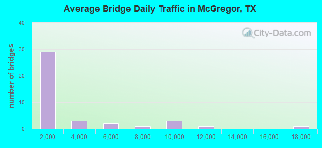
- 90,198Total average daily traffic
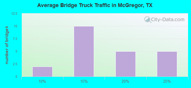
- 9,647Total average daily truck traffic
- 125,717Total future (year 2030) average daily traffic
- National Bridge Inventory (NBI) Registered Bridges for McGregor
- No street view available for this location
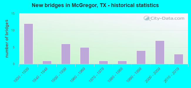
- New bridges - historical statistics
- 121930-1939
- 11940-1949
- 61950-1959
- 51960-1969
- 11970-1979
- 11980-1989
- 41990-1999
- 72000-2009
- 32010-2019
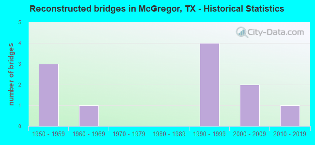
- Reconstructed bridges - Historical Statistics
- 31950-1959
- 11960-1969
- 01970-1979
- 01980-1989
- 41990-1999
- 22000-2009
- 12010-2019
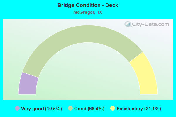
- Bridge Condition - Deck
- 10.5%Very good
- 68.4%Good
- 21.1%Satisfactory
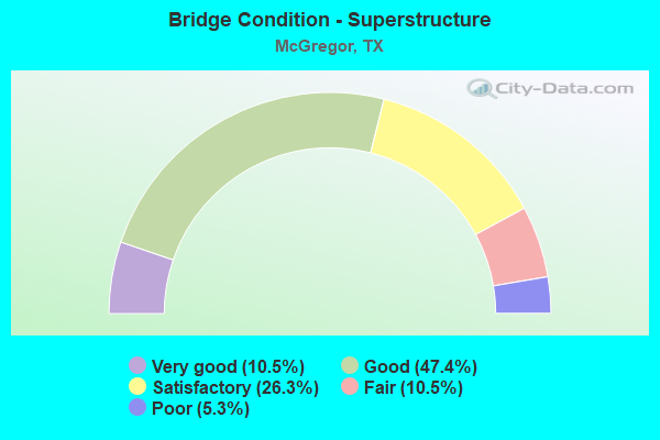
- Bridge Condition - Superstructure
- 10.5%Very good
- 47.4%Good
- 26.3%Satisfactory
- 10.5%Fair
- 5.3%Poor
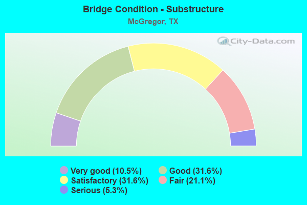
- Bridge Condition - Substructure
- 10.5%Very good
- 31.6%Good
- 31.6%Satisfactory
- 21.1%Fair
- 5.3%Serious
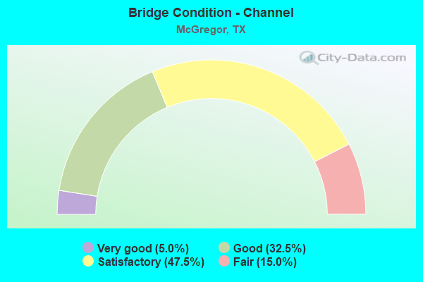
- Bridge Condition - Channel
- 5.0%Very good
- 32.5%Good
- 47.5%Satisfactory
- 15.0%Fair
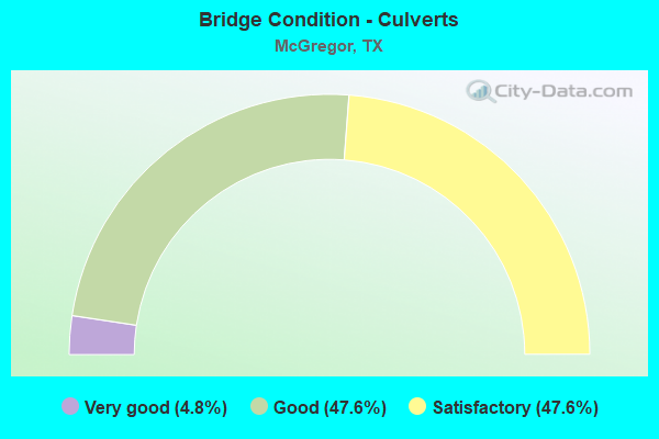
- Bridge Condition - Culverts
- 4.8%Very good
- 47.6%Good
- 47.6%Satisfactory
Find on map >> Show street view
Structure Number: 90500056701005, Location: 1.55 MI SE OF FM 1996 (Lat: 31.367269, Lng: -97.496539), Route carried "on" structure: State highway 107, Year Built: 1953, Year Reconstructed: 2007, Status: Open, Structure Length: 1.77m (5.81ft), Average Daily Traffic: 799 (year 2020), Truck Traffic: 20%, Average Future Daily Traffic: 1,330 (year 2033), Design Load: HS 20, Features Intersected: STATION CREEK
Minimum Vertical Clearance: 30+ m (98+ ft), Kilometerpoint: 9.785, Lanes on structure: 2, Owner: State Highway Agency, Approaching Roadway Width: 13.7m (44.9ft), Skew: 9 degrees, Material/Design: Concrete, Design/Construction: Culvert, Number Of Spans In Main Unit: 5, Length of Maximum Span: 3.0m (9.8ft)
Condition: Channel: Good, Culverts: Good, Operating Rating: 39.9 metric tons, Method Used To Determine Operating Rating: Load Factor (LF), Inventory Rating: 23.6 metric tons, Method Used To Determine Inventory Rating: Load Factor (LF), Structural Evaluation: Equal to present minimum criteria, Waterway Adequacy: Equal to present minimum criteria, Approach Roadway Alignment: Equal to present desirable criteria, Length Of Structure Improvement: 1.83m (6.00ft), Designated Inspection Frequency: Every 24 months, Inspection Date: October 2020, Bridge Improvement Cost: $200,000, Roadway Improvement Cost: $100,000, Total Project Cost: $300,000
Find on map >> Show street view
Structure Number: 90500056701012, Location: 3.10 MI SE OF FM 1996 (Lat: 31.351792, Lng: -97.479400), Route carried "on" structure: State highway 107, Year Built: 2007, Status: Open, Structure Length: 3.51m (11.52ft), Average Daily Traffic: 1,469 (year 2020), Truck Traffic: 19%, Average Future Daily Traffic: 1,330 (year 2030), Design Load: HL 93, Features Intersected: ONION CREEK
Minimum Vertical Clearance: 30+ m (98+ ft), Kilometerpoint: 12.229, Lanes on structure: 2, Owner: State Highway Agency, Approaching Roadway Width: 14.0m (45.9ft), Material/Design: Prestressed concrete, Design/Construction: Stringer/Multi-beam, Number Of Spans In Main Unit: 1, Length of Maximum Span: 35.1m (115.2ft), Curb-To-Curb Width: 13.3m (43.6ft), Out-to-Out Width: 14.0m (45.9ft)
Condition: Deck: Good, Superstructure: Good, Substructure: Good, Channel: Good, Operating Rating: 54.4 metric tons, Method Used To Determine Operating Rating: Assigned ratings based on Load and Resistance Factor Design (LRFD) reported in metric tons, Inventory Rating: 32.7 metric tons, Method Used To Determine Inventory Rating: Assigned ratings based on Load and Resistance Factor Design (LRFD) reported in metric tons, Structural Evaluation: Better than present minimum criteria, Deck Geometry: Better than present minimum criteria, Waterway Adequacy: Superior to present desirable criteria, Approach Roadway Alignment: Equal to present desirable criteria, Designated Inspection Frequency: Every 24 months, Inspection Date: October 2020, Deck Structure Type: Concrete Precast Panels
Find on map >> Show street view
Structure Number: 9050025050201, Location: 0.95 MI NW OF FM 1996 (Lat: 31.382594, Lng: -97.534597), Route carried "on" structure: State highway 107, Year Built: 1964, Year Reconstructed: 2000, Status: Open, Structure Length: 3.35m (10.99ft), Average Daily Traffic: 956 (year 2020), Truck Traffic: 22%, Average Future Daily Traffic: 1,260 (year 2033), Design Load: H 20, Features Intersected: PEW BRANCH
Minimum Vertical Clearance: 30+ m (98+ ft), Kilometerpoint: 18.421, Lanes on structure: 2, Owner: State Highway Agency, Approaching Roadway Width: 14.0m (45.9ft), Material/Design: Concrete continuous, Design/Construction: Slab, Number Of Spans In Main Unit: 4, Length of Maximum Span: 9.1m (29.9ft), Curb-To-Curb Width: 11.8m (38.7ft), Out-to-Out Width: 12.7m (41.7ft)
Condition: Deck: Good, Superstructure: Good, Substructure: Good, Channel: Good, Operating Rating: 51.7 metric tons, Method Used To Determine Operating Rating: Load Factor (LF), Inventory Rating: 30.8 metric tons, Method Used To Determine Inventory Rating: Load Factor (LF), Structural Evaluation: Better than present minimum criteria, Deck Geometry: Better than present minimum criteria, Waterway Adequacy: Equal to present minimum criteria, Approach Roadway Alignment: Equal to present desirable criteria, Length Of Structure Improvement: 4.57m (14.99ft), Designated Inspection Frequency: Every 24 months, Inspection Date: October 2020, Bridge Improvement Cost: $500,000, Roadway Improvement Cost: $200,000, Total Project Cost: $800,000, Deck Structure Type: Concrete Cast-file-Place, Wearing Surface/Protective System: Wearing Surface: Bituminous
Find on map >> Show street view
Structure Number: 90500267401001, Location: 1.76 MI N OF FM 107 (Lat: 31.363850, Lng: -97.451550), Route carried "on" structure: State highway 2671, Year Built: 1963, Status: Open, Structure Length: 0.85m (2.79ft), Average Daily Traffic: 653 (year 2020), Truck Traffic: 19%, Average Future Daily Traffic: 700 (year 2033), Design Load: HS 20, Features Intersected: TRIB OF LEON RIVER
Minimum Vertical Clearance: 30+ m (98+ ft), Kilometerpoint: 0.274, Lanes on structure: 2, Owner: State Highway Agency, Approaching Roadway Width: 7.3m (24.0ft), Skew: 4 degrees, Material/Design: Concrete, Design/Construction: Culvert, Number Of Spans In Main Unit: 3, Length of Maximum Span: 1.8m (5.9ft), Curb-To-Curb Width: 7.3m (24.0ft), Out-to-Out Width: 10.5m (34.4ft)
Condition: Channel: Satisfactory, Culverts: Satisfactory, Operating Rating: 39.9 metric tons, Method Used To Determine Operating Rating: Load Factor (LF), Inventory Rating: 23.6 metric tons, Method Used To Determine Inventory Rating: Load Factor (LF), Structural Evaluation: Equal to present minimum criteria, Deck Geometry: Meets minimum limits, Waterway Adequacy: Equal to present minimum criteria, Approach Roadway Alignment: Equal to present desirable criteria, Length Of Structure Improvement: 1.83m (6.00ft), Designated Inspection Frequency: Every 24 months, Inspection Date: October 2020, Bridge Improvement Cost: $200,000, Roadway Improvement Cost: $100,000, Total Project Cost: $400,000, Deck Structure Type: Concrete Cast-file-Place, Wearing Surface/Protective System: Wearing Surface: Bituminous
Find on map >> Show street view
Structure Number: 90500AA0314002, Location: 4.30 MI NW OF SH 236 (Lat: 31.354219, Lng: -97.515822), Route carried "on" structure: County highway 314, Year Built: 1935, Status: Posted for load, Structure Length: 1.40m (4.59ft), Average Daily Traffic: 66 (year 2016), Average Future Daily Traffic: 35 (year 2036), Features Intersected: BR OF LEON RI #25
Minimum Vertical Clearance: 30+ m (98+ ft), Kilometerpoint: 6.276, Lanes on structure: 1, Owner: County Highway Agency, Approaching Roadway Width: 4.9m (16.1ft), Material/Design: Wood or Timber, Design/Construction: Stringer/Multi-beam, Number Of Spans In Main Unit: 3, Length of Maximum Span: 4.6m (15.1ft), Curb-To-Curb Width: 7.2m (23.6ft), Out-to-Out Width: 7.3m (24.0ft)
Condition: Deck: Good, Superstructure: Fair, Substructure: Fair, Channel: Satisfactory, Operating Rating: 17.2 metric tons, Method Used To Determine Operating Rating: Allowable Stress (AS), Inventory Rating: 12.7 metric tons, Method Used To Determine Inventory Rating: Allowable Stress (AS), Structural Evaluation: Meets minimum limits, Deck Geometry: Somewhat better than minimum adequacy, Waterway Adequacy: Meets minimum limits, Approach Roadway Alignment: Better than present minimum criteria, Bridge Posting: Required (Relationship of Operating Rating to Maximum Legal Load: > 39.9% below), Length Of Structure Improvement: 1.83m (6.00ft), Designated Inspection Frequency: Every 24 months, Inspection Date: April 2020, Bridge Improvement Cost: $167,000, Roadway Improvement Cost: $41,000, Total Project Cost: $208,000, Deck Structure Type: Wood or Timber, Wearing Surface/Protective System: Wearing Surface: Wood or Timber
Find on map >> Show street view
Structure Number: 90500AA0315001, Location: 0.90 MI W OF FM 107 (Lat: 31.374911, Lng: -97.537889), Route carried "on" structure: County highway 315, Year Built: 1930, Year Reconstructed: 2004, Status: Open, Structure Length: 1.25m (4.10ft), Average Daily Traffic: 44 (year 2016), Average Future Daily Traffic: 120 (year 2036), Features Intersected: PEW BRANCH #22
Minimum Vertical Clearance: 30+ m (98+ ft), Kilometerpoint: 1.448, Lanes on structure: 1, Owner: County Highway Agency, Approaching Roadway Width: 4.3m (14.1ft), Material/Design: Steel continuous, Number Of Spans In Main Unit: 3, Length of Maximum Span: 5.5m (18.0ft), Curb-To-Curb Width: 5.1m (16.7ft), Out-to-Out Width: 5.1m (16.7ft)
Condition: Deck: Good, Superstructure: Fair, Substructure: Satisfactory, Channel: Fair, Operating Rating: 55.3 metric tons, Method Used To Determine Operating Rating: Allowable Stress (AS), Inventory Rating: 39.0 metric tons, Method Used To Determine Inventory Rating: Allowable Stress (AS), Structural Evaluation: Somewhat better than minimum adequacy, Deck Geometry: High priority of corrective action, Waterway Adequacy: Meets minimum limits, Approach Roadway Alignment: Meets minimum limits, Length Of Structure Improvement: 1.83m (6.00ft), Designated Inspection Frequency: Every 24 months, Inspection Date: April 2020, Bridge Improvement Cost: $167,000, Roadway Improvement Cost: $41,000, Total Project Cost: $208,000, Deck Structure Type: Concrete Cast-file-Place
Find on map >> Show street view
Structure Number: 90500AA0344001, Location: 3.50 MI E OF FM 931 (Lat: 31.352081, Lng: -97.532892), Route carried "on" structure: County highway 344, Year Built: 1995, Status: Open, Structure Length: 7.32m (24.02ft), Average Daily Traffic: 100 (year 2020), Average Future Daily Traffic: 100 (year 2036), Design Load: HS 20, Features Intersected: LEON RI #24
Minimum Vertical Clearance: 30+ m (98+ ft), Kilometerpoint: 2.253, Lanes on structure: 2, Owner: County Highway Agency, Approaching Roadway Width: 6.1m (20.0ft), Skew: 3 degrees, Material/Design: Prestressed concrete, Design/Construction: Stringer/Multi-beam, Number Of Spans In Main Unit: 3, Length of Maximum Span: 24.4m (80.1ft), Curb-To-Curb Width: 7.0m (23.0ft), Out-to-Out Width: 7.9m (25.9ft)
Condition: Deck: Good, Superstructure: Good, Substructure: Satisfactory, Channel: Fair, Operating Rating: 54.4 metric tons, Method Used To Determine Operating Rating: Assigned rating based on Load Factor Design (LFD) reported in metric tons, Inventory Rating: 32.7 metric tons, Method Used To Determine Inventory Rating: Assigned rating based on Load Factor Design (LFD) reported in metric tons, Structural Evaluation: Equal to present minimum criteria, Deck Geometry: Somewhat better than minimum adequacy, Waterway Adequacy: Equal to present minimum criteria, Approach Roadway Alignment: Better than present minimum criteria, Designated Inspection Frequency: Every 24 months, Inspection Date: April 2020, Deck Structure Type: Concrete Precast Panels
Find on map >> Show street view
Structure Number: 91610005507011, Location: 1.10 Mi E of FM 938 (Lat: 31.439283, Lng: -97.443200), Route carried "on" structure: US 84, Year Built: 1933, Year Reconstructed: 2016, Status: Open, Structure Length: 0.70m (2.30ft), Average Daily Traffic: 8,262 (year 2020), Truck Traffic: 11%, Average Future Daily Traffic: 10,770 (year 2037), Design Load: H 15, Features Intersected: Trib Harris Creek
Minimum Vertical Clearance: 30+ m (98+ ft), Kilometerpoint: 5.502, Lanes on structure: 3, Base Highway Network: Yes, Owner: State Highway Agency, Approaching Roadway Width: 14.6m (47.9ft), Material/Design: Concrete, Design/Construction: Culvert, Number Of Spans In Main Unit: 5, Length of Maximum Span: 1.2m (3.9ft), Curb-To-Curb Width: 14.9m (48.9ft), Out-to-Out Width: 17.1m (56.1ft)
Condition: Channel: Satisfactory, Culverts: Satisfactory, Operating Rating: 39.9 metric tons, Method Used To Determine Operating Rating: Load Factor (LF), Inventory Rating: 23.6 metric tons, Method Used To Determine Inventory Rating: Load Factor (LF), Structural Evaluation: Somewhat better than minimum adequacy, Deck Geometry: Equal to present minimum criteria, Waterway Adequacy: Equal to present minimum criteria, Approach Roadway Alignment: Equal to present desirable criteria, Length Of Structure Improvement: 1.83m (6.00ft), Designated Inspection Frequency: Every 24 months, Inspection Date: December 2020, Bridge Improvement Cost: $200,000, Roadway Improvement Cost: $100,000, Total Project Cost: $400,000, Deck Structure Type: Concrete Cast-file-Place, Wearing Surface/Protective System: Wearing Surface: Bituminous
Find on map >> Show street view
Structure Number: 91610005507012, Location: 1.90 Mi E of FM 938 (Lat: 31.439797, Lng: -97.430611), Route carried "on" structure: US 84, Year Built: 1933, Year Reconstructed: 1956, Status: Open, Structure Length: 1.95m (6.40ft), Average Daily Traffic: 8,262 (year 2020), Truck Traffic: 11%, Average Future Daily Traffic: 10,770 (year 2037), Features Intersected: Harris Creek
Minimum Vertical Clearance: 30+ m (98+ ft), Kilometerpoint: 6.696, Lanes on structure: 2, Base Highway Network: Yes, Owner: State Highway Agency, Approaching Roadway Width: 13.4m (44.0ft), Skew: 4 degrees, Material/Design: Concrete, Design/Construction: Culvert, Number Of Spans In Main Unit: 4, Length of Maximum Span: 3.0m (9.8ft), Curb-To-Curb Width: 13.0m (42.7ft), Out-to-Out Width: 14.4m (47.2ft)
Condition: Channel: Satisfactory, Culverts: Satisfactory, Operating Rating: 32.7 metric tons, Method Used To Determine Operating Rating: Field evaluation and documented engineering judgment, Inventory Rating: 24.5 metric tons, Method Used To Determine Inventory Rating: Field evaluation and documented engineering judgment, Structural Evaluation: Equal to present minimum criteria, Deck Geometry: Somewhat better than minimum adequacy, Waterway Adequacy: Equal to present minimum criteria, Approach Roadway Alignment: Equal to present desirable criteria, Length Of Structure Improvement: 2.74m (8.99ft), Designated Inspection Frequency: Every 24 months, Inspection Date: December 2020, Bridge Improvement Cost: $300,000, Roadway Improvement Cost: $100,000, Total Project Cost: $500,000, Deck Structure Type: Concrete Cast-file-Place, Wearing Surface/Protective System: Wearing Surface: Bituminous
Find on map >> Show street view
Structure Number: 91610005507013, Location: 2.40 Mi E of FM 938 (Lat: 31.440261, Lng: -97.421978), Route carried "on" structure: US 84, Year Built: 1933, Year Reconstructed: 1956, Status: Open, Structure Length: 1.04m (3.41ft), Average Daily Traffic: 8,262 (year 2020), Truck Traffic: 11%, Average Future Daily Traffic: 10,777 (year 2037), Design Load: H 15, Features Intersected: Br Harris Creek
Minimum Vertical Clearance: 30+ m (98+ ft), Kilometerpoint: 7.520, Lanes on structure: 2, Base Highway Network: Yes, Owner: State Highway Agency, Approaching Roadway Width: 12.8m (42.0ft), Material/Design: Concrete, Design/Construction: Culvert, Number Of Spans In Main Unit: 5, Length of Maximum Span: 1.8m (5.9ft), Curb-To-Curb Width: 11.6m (38.1ft), Out-to-Out Width: 14.5m (47.6ft)
Condition: Channel: Satisfactory, Culverts: Satisfactory, Operating Rating: 39.9 metric tons, Method Used To Determine Operating Rating: Load Factor (LF), Inventory Rating: 23.6 metric tons, Method Used To Determine Inventory Rating: Load Factor (LF), Structural Evaluation: Somewhat better than minimum adequacy, Deck Geometry: Somewhat better than minimum adequacy, Waterway Adequacy: Equal to present minimum criteria, Approach Roadway Alignment: Equal to present desirable criteria, Length Of Structure Improvement: 1.83m (6.00ft), Designated Inspection Frequency: Every 24 months, Inspection Date: December 2020, Bridge Improvement Cost: $200,000, Roadway Improvement Cost: $100,000, Total Project Cost: $400,000, Deck Structure Type: Concrete Cast-file-Place, Wearing Surface/Protective System: Wearing Surface: Bituminous
Find on map >> Show street view
Structure Number: 91610005507063, Location: 5.60 Mi E of SH 317 (Lat: 31.475050, Lng: -97.320569), Route carried "on" structure: US 84, Year Built: 1966, Status: Open, Structure Length: 6.46m (21.19ft), Average Daily Traffic: 10,350 (year 2020), Truck Traffic: 7%, Average Future Daily Traffic: 16,055 (year 2037), Design Load: H 20, Features Intersected: Harris Creek
Minimum Vertical Clearance: 30+ m (98+ ft), Kilometerpoint: 17.844, Lanes on structure: 3, Base Highway Network: Yes, Owner: State Highway Agency, Approaching Roadway Width: 13.7m (44.9ft), Material/Design: Concrete, Design/Construction: Stringer/Multi-beam, Number Of Spans In Main Unit: 7, Length of Maximum Span: 9.1m (29.9ft), Curb-To-Curb Width: 13.0m (42.7ft), Out-to-Out Width: 13.9m (45.6ft)
Condition: Deck: Good, Superstructure: Good, Substructure: Good, Channel: Satisfactory, Operating Rating: 59.9 metric tons, Method Used To Determine Operating Rating: Load Factor (LF), Inventory Rating: 35.4 metric tons, Method Used To Determine Inventory Rating: Load Factor (LF), Structural Evaluation: Better than present minimum criteria, Deck Geometry: Meets minimum limits, Waterway Adequacy: Equal to present minimum criteria, Approach Roadway Alignment: Equal to present desirable criteria, Length Of Structure Improvement: 8.23m (27.00ft), Designated Inspection Frequency: Every 24 months, Inspection Date: December 2020, Bridge Improvement Cost: $800,000, Roadway Improvement Cost: $200,000, Total Project Cost: $1,200,000, Deck Structure Type: Concrete Cast-file-Place, Wearing Surface/Protective System: Wearing Surface: Bituminous
Find on map >> Show street view
Structure Number: 91610005507073, Location: 3.1 Mi E of FM 938 (Lat: 31.443983, Lng: -97.409756), Route carried "on" structure: US 84, Year Built: 1995, Status: Open, Structure Length: 1.31m (4.30ft), Average Daily Traffic: 16,464 (year 2020), Truck Traffic: 8%, Average Future Daily Traffic: 20,160 (year 2037), Design Load: HS 20, Features Intersected: Trib Harris Creek
Minimum Vertical Clearance: 30+ m (98+ ft), Kilometerpoint: 8.764, Lanes on structure: 7, Base Highway Network: Yes, Owner: State Highway Agency, Approaching Roadway Width: 20.7m (67.9ft), Material/Design: Concrete, Design/Construction: Culvert, Number Of Spans In Main Unit: 5, Length of Maximum Span: 2.4m (7.9ft), Curb-To-Curb Width: 26.8m (87.9ft), Out-to-Out Width: 29.7m (97.4ft)
Condition: Channel: Good, Culverts: Good, Operating Rating: 39.9 metric tons, Method Used To Determine Operating Rating: Load Factor (LF), Inventory Rating: 23.6 metric tons, Method Used To Determine Inventory Rating: Load Factor (LF), Structural Evaluation: Somewhat better than minimum adequacy, Deck Geometry: Somewhat better than minimum adequacy, Waterway Adequacy: Equal to present minimum criteria, Approach Roadway Alignment: Equal to present desirable criteria, Length Of Structure Improvement: 1.83m (6.00ft), Designated Inspection Frequency: Every 48 months, Inspection Date: May 2019, Bridge Improvement Cost: $200,000, Roadway Improvement Cost: $100,000, Total Project Cost: $400,000, Deck Structure Type: Concrete Cast-file-Place, Wearing Surface/Protective System: Wearing Surface: Bituminous
Find on map >> Show street view
Structure Number: 91610039802036, Location: 2.2 Mi N of US 84 (Lat: 31.474308, Lng: -97.418850), Route carried "on" structure: State highway 317, Year Built: 1958, Status: Open, Structure Length: 3.35m (10.99ft), Average Daily Traffic: 2,888 (year 2020), Truck Traffic: 14%, Average Future Daily Traffic: 3,960 (year 2037), Design Load: H 20, Features Intersected: Pecan Creek
Minimum Vertical Clearance: 30+ m (98+ ft), Kilometerpoint: 20.542, Lanes on structure: 2, Base Highway Network: Yes, Owner: State Highway Agency, Approaching Roadway Width: 13.4m (44.0ft), Skew: 3 degrees, Material/Design: Concrete continuous, Design/Construction: Slab, Number Of Spans In Main Unit: 4, Length of Maximum Span: 9.1m (29.9ft), Curb-To-Curb Width: 13.0m (42.7ft), Out-to-Out Width: 13.8m (45.3ft)
Condition: Deck: Good, Superstructure: Good, Substructure: Good, Channel: Satisfactory, Operating Rating: 49.9 metric tons, Method Used To Determine Operating Rating: Load Factor (LF), Inventory Rating: 29.9 metric tons, Method Used To Determine Inventory Rating: Load Factor (LF), Structural Evaluation: Better than present minimum criteria, Deck Geometry: Equal to present minimum criteria, Waterway Adequacy: Equal to present minimum criteria, Approach Roadway Alignment: Equal to present desirable criteria, Length Of Structure Improvement: 4.57m (14.99ft), Designated Inspection Frequency: Every 24 months, Inspection Date: January 2021, Bridge Improvement Cost: $500,000, Roadway Improvement Cost: $200,000, Total Project Cost: $900,000, Deck Structure Type: Concrete Cast-file-Place, Wearing Surface/Protective System: Wearing Surface: Bituminous
Find on map >> Show street view
Structure Number: 91610039803006, Location: 0.3 Mi N of US 84 (Lat: 31.446164, Lng: -97.410458), Route carried "on" structure: State highway 317, Year Built: 1939, Year Reconstructed: 1963, Status: Open, Structure Length: 4.27m (14.01ft), Average Daily Traffic: 6,431 (year 2019), Truck Traffic: 10%, Average Future Daily Traffic: 9,070 (year 2037), Design Load: H 15, Features Intersected: Harris Creek
Minimum Vertical Clearance: 30+ m (98+ ft), Kilometerpoint: 23.728, Lanes on structure: 2, Owner: State Highway Agency, Approaching Roadway Width: 13.4m (44.0ft), Skew: 4 degrees, Material/Design: Concrete, Design/Construction: Slab, Number Of Spans In Main Unit: 6, Length of Maximum Span: 7.0m (23.0ft), Curb-To-Curb Width: 12.6m (41.3ft), Out-to-Out Width: 13.5m (44.3ft)
Condition: Deck: Good, Superstructure: Good, Substructure: Satisfactory, Channel: Satisfactory, Operating Rating: 40.8 metric tons, Method Used To Determine Operating Rating: Load Factor (LF), Inventory Rating: 24.5 metric tons, Method Used To Determine Inventory Rating: Load Factor (LF), Structural Evaluation: Equal to present minimum criteria, Deck Geometry: Somewhat better than minimum adequacy, Waterway Adequacy: Equal to present minimum criteria, Approach Roadway Alignment: Equal to present desirable criteria, Length Of Structure Improvement: 5.49m (18.01ft), Designated Inspection Frequency: Every 24 months, Inspection Date: December 2020, Bridge Improvement Cost: $600,000, Roadway Improvement Cost: $200,000, Total Project Cost: $1,000,000, Deck Structure Type: Concrete Cast-file-Place, Wearing Surface/Protective System: Wearing Surface: Bituminous
Find on map >> Show street view
Structure Number: 91610039803007, Location: 2.3 Mi S of US 84 (Lat: 31.413858, Lng: -97.391817), Route carried "on" structure: State highway 317, Year Built: 1939, Year Reconstructed: 1998, Status: Open, Structure Length: 1.19m (3.90ft), Average Daily Traffic: 5,753 (year 2020), Truck Traffic: 11%, Average Future Daily Traffic: 7,700 (year 2037), Design Load: H 15, Features Intersected: Tributary S Bosque River
Minimum Vertical Clearance: 30+ m (98+ ft), Kilometerpoint: 27.755, Lanes on structure: 2, Base Highway Network: Yes, Owner: State Highway Agency, Approaching Roadway Width: 10.4m (34.1ft), Material/Design: Concrete, Design/Construction: Culvert, Number Of Spans In Main Unit: 5, Length of Maximum Span: 2.1m (6.9ft), Curb-To-Curb Width: 9.4m (30.8ft), Out-to-Out Width: 18.2m (59.7ft)
Condition: Channel: Satisfactory, Culverts: Good, Operating Rating: 39.9 metric tons, Method Used To Determine Operating Rating: Load Factor (LF), Inventory Rating: 23.6 metric tons, Method Used To Determine Inventory Rating: Load Factor (LF), Structural Evaluation: Somewhat better than minimum adequacy, Deck Geometry: High priority of corrective action, Waterway Adequacy: Equal to present minimum criteria, Approach Roadway Alignment: Equal to present desirable criteria, Length Of Structure Improvement: 1.83m (6.00ft), Designated Inspection Frequency: Every 24 months, Inspection Date: December 2020, Bridge Improvement Cost: $200,000, Roadway Improvement Cost: $100,000, Total Project Cost: $400,000, Deck Structure Type: Concrete Cast-file-Place, Wearing Surface/Protective System: Wearing Surface: Bituminous
Find on map >> Show street view
Structure Number: 91610039803008, Location: 3.4 Mi S of US 84 (Lat: 31.399386, Lng: -97.383706), Route carried "on" structure: State highway 317, Year Built: 1939, Year Reconstructed: 1998, Status: Open, Structure Length: 0.88m (2.89ft), Average Daily Traffic: 5,753 (year 2020), Truck Traffic: 11%, Average Future Daily Traffic: 7,700 (year 2037), Design Load: H 15, Features Intersected: Tributary S Bosque River
Minimum Vertical Clearance: 30+ m (98+ ft), Kilometerpoint: 29.538, Lanes on structure: 2, Base Highway Network: Yes, Owner: State Highway Agency, Approaching Roadway Width: 10.4m (34.1ft), Material/Design: Concrete, Design/Construction: Culvert, Number Of Spans In Main Unit: 5, Length of Maximum Span: 1.5m (4.9ft), Curb-To-Curb Width: 10.1m (33.1ft), Out-to-Out Width: 17.6m (57.7ft)
Condition: Channel: Good, Culverts: Satisfactory, Operating Rating: 39.9 metric tons, Method Used To Determine Operating Rating: Load Factor (LF), Inventory Rating: 23.6 metric tons, Method Used To Determine Inventory Rating: Load Factor (LF), Structural Evaluation: Somewhat better than minimum adequacy, Deck Geometry: Meets minimum limits, Waterway Adequacy: Equal to present minimum criteria, Approach Roadway Alignment: Equal to present desirable criteria, Length Of Structure Improvement: 1.83m (6.00ft), Designated Inspection Frequency: Every 24 months, Inspection Date: December 2020, Bridge Improvement Cost: $200,000, Roadway Improvement Cost: $100,000, Total Project Cost: $400,000, Deck Structure Type: Concrete Cast-file-Place, Wearing Surface/Protective System: Wearing Surface: Bituminous
Find on map >> Show street view
Structure Number: 91610039803009, Location: 4.1 Mi S of US 84 (Lat: 31.389372, Lng: -97.382156), Route carried "on" structure: State highway 317, Year Built: 1939, Year Reconstructed: 1960, Status: Temporarily open, Structure Length: 6.40m (21.00ft), Average Daily Traffic: 3,957 (year 2020), Truck Traffic: 14%, Average Future Daily Traffic: 5,370 (year 2037), Design Load: H 15, Features Intersected: S Bosque River
Minimum Vertical Clearance: 30+ m (98+ ft), Kilometerpoint: 30.615, Lanes on structure: 2, Base Highway Network: Yes, Owner: State Highway Agency, Approaching Roadway Width: 10.4m (34.1ft), Material/Design: Concrete, Design/Construction: Tee Beam, Number Of Spans In Main Unit: 7, Length of Maximum Span: 9.1m (29.9ft), Curb-To-Curb Width: 13.1m (43.0ft), Out-to-Out Width: 13.8m (45.3ft)
Condition: Deck: Satisfactory, Superstructure: Poor, Substructure: Fair, Channel: Satisfactory, Operating Rating: 29.0 metric tons, Method Used To Determine Operating Rating: Load Factor (LF), Inventory Rating: 17.2 metric tons, Method Used To Determine Inventory Rating: Load Factor (LF), Structural Evaluation: Meets minimum limits, Deck Geometry: Equal to present minimum criteria, Waterway Adequacy: Equal to present minimum criteria, Approach Roadway Alignment: Equal to present desirable criteria, Length Of Structure Improvement: 8.23m (27.00ft), Designated Inspection Frequency: Every 24 months, Inspection Date: December 2020, Bridge Improvement Cost: $800,000, Roadway Improvement Cost: $200,000, Total Project Cost: $1,200,000, Deck Structure Type: Concrete Cast-file-Place, Wearing Surface/Protective System: Wearing Surface: Bituminous
Find on map >> Show street view
Structure Number: 9161003980301, Location: 5.3 Mi S of US 84 (Lat: 31.370831, Lng: -97.382169), Route carried "on" structure: State highway 317, Year Built: 1939, Year Reconstructed: 1998, Status: Open, Structure Length: 0.73m (2.40ft), Average Daily Traffic: 3,957 (year 2020), Truck Traffic: 14%, Average Future Daily Traffic: 5,370 (year 2037), Design Load: H 15, Features Intersected: Tributary S Bosque River
Minimum Vertical Clearance: 30+ m (98+ ft), Kilometerpoint: 32.485, Lanes on structure: 2, Base Highway Network: Yes, Owner: State Highway Agency, Approaching Roadway Width: 10.4m (34.1ft), Material/Design: Concrete, Design/Construction: Culvert, Number Of Spans In Main Unit: 3, Length of Maximum Span: 2.1m (6.9ft)
Condition: Channel: Fair, Culverts: Good, Operating Rating: 39.9 metric tons, Method Used To Determine Operating Rating: Load Factor (LF), Inventory Rating: 23.6 metric tons, Method Used To Determine Inventory Rating: Load Factor (LF), Structural Evaluation: Equal to present minimum criteria, Waterway Adequacy: Equal to present minimum criteria, Approach Roadway Alignment: Equal to present desirable criteria, Length Of Structure Improvement: 1.83m (6.00ft), Designated Inspection Frequency: Every 24 months, Inspection Date: December 2020, Bridge Improvement Cost: $200,000, Roadway Improvement Cost: $100,000, Total Project Cost: $400,000
Find on map >> Show street view
Structure Number: 91610039803039, Location: 6.4 Mi S of US 84 (Lat: 31.358628, Lng: -97.380350), Route carried "on" structure: ServiceState highway 317, Year Built: 1994, Status: Open, Structure Length: 0.70m (2.30ft), Average Daily Traffic: 50 (year 2010), Truck Traffic: 16%, Average Future Daily Traffic: 6,440 (year 2030), Design Load: HS 20, Features Intersected: Trib S Bosque River
Minimum Vertical Clearance: 30+ m (98+ ft), Kilometerpoint: 29.763, Lanes on structure: 2, Owner: State Highway Agency, Approaching Roadway Width: 5.5m (18.0ft), Material/Design: Concrete, Design/Construction: Culvert, Number Of Spans In Main Unit: 3, Length of Maximum Span: 2.1m (6.9ft), Curb-To-Curb Width: 7.8m (25.6ft), Out-to-Out Width: 14.7m (48.2ft)
Condition: Channel: Good, Culverts: Good, Operating Rating: 39.9 metric tons, Method Used To Determine Operating Rating: Load Factor (LF), Inventory Rating: 23.6 metric tons, Method Used To Determine Inventory Rating: Load Factor (LF), Structural Evaluation: Equal to present minimum criteria, Deck Geometry: Equal to present minimum criteria, Waterway Adequacy: Better than present minimum criteria, Approach Roadway Alignment: Somewhat better than minimum adequacy, Length Of Structure Improvement: 1.83m (6.00ft), Designated Inspection Frequency: Every 48 months, Inspection Date: January 2021, Bridge Improvement Cost: $200,000, Roadway Improvement Cost: $100,000, Total Project Cost: $400,000, Deck Structure Type: Concrete Cast-file-Place, Wearing Surface/Protective System: Wearing Surface: Bituminous
Find on map >> Show street view
Structure Number: 91610118702004, Location: 2.1 Mi NW of US 84 (Lat: 31.464203, Lng: -97.480261), Route carried "on" structure: State highway 938, Year Built: 1951, Status: Open, Structure Length: 0.81m (2.66ft), Average Daily Traffic: 162 (year 2020), Truck Traffic: 19%, Average Future Daily Traffic: 260 (year 2037), Features Intersected: Wasp Creek
Minimum Vertical Clearance: 30+ m (98+ ft), Kilometerpoint: 6.313, Lanes on structure: 2, Owner: State Highway Agency, Approaching Roadway Width: 6.7m (22.0ft), Material/Design: Concrete, Design/Construction: Culvert, Number Of Spans In Main Unit: 3, Length of Maximum Span: 2.4m (7.9ft)
Condition: Channel: Fair, Culverts: Satisfactory, Operating Rating: 39.9 metric tons, Method Used To Determine Operating Rating: Load Factor (LF), Inventory Rating: 23.6 metric tons, Method Used To Determine Inventory Rating: Load Factor (LF), Structural Evaluation: Equal to present minimum criteria, Waterway Adequacy: Better than present minimum criteria, Approach Roadway Alignment: Somewhat better than minimum adequacy, Length Of Structure Improvement: 1.83m (6.00ft), Designated Inspection Frequency: Every 24 months, Inspection Date: December 2020, Bridge Improvement Cost: $200,000, Roadway Improvement Cost: $100,000, Total Project Cost: $400,000
Find on map >> Show street view
Structure Number: 91610231001001, Location: 3.6 Mi SE of SH 317 (Lat: 31.426681, Lng: -97.359361), Route carried "on" structure: State highway 2416, Year Built: 1958, Status: Open, Structure Length: 0.70m (2.30ft), Average Daily Traffic: 569 (year 2020), Truck Traffic: 11%, Average Future Daily Traffic: 780 (year 2037), Features Intersected: Tributary S Bosque River
Minimum Vertical Clearance: 30+ m (98+ ft), Kilometerpoint: 5.798, Lanes on structure: 2, Owner: State Highway Agency, Approaching Roadway Width: 7.3m (24.0ft), Skew: 1 degrees, Material/Design: Concrete, Design/Construction: Culvert, Number Of Spans In Main Unit: 4, Length of Maximum Span: 1.5m (4.9ft)
Condition: Channel: Satisfactory, Culverts: Satisfactory, Operating Rating: 39.9 metric tons, Method Used To Determine Operating Rating: Load Factor (LF), Inventory Rating: 23.6 metric tons, Method Used To Determine Inventory Rating: Load Factor (LF), Structural Evaluation: Equal to present minimum criteria, Waterway Adequacy: Better than present minimum criteria, Approach Roadway Alignment: Equal to present minimum criteria, Designated Inspection Frequency: Every 24 months, Inspection Date: December 2020
Find on map >> Show street view
Structure Number: 91610239701001, Location: 0.5 Mi S of US 84 (Lat: 31.460086, Lng: -97.342219), Route carried "on" structure: State highway 2188, Year Built: 1958, Status: Open, Structure Length: 0.79m (2.59ft), Average Daily Traffic: 971 (year 2020), Truck Traffic: 17%, Average Future Daily Traffic: 950 (year 2037), Features Intersected: Harris Creek
Minimum Vertical Clearance: 30+ m (98+ ft), Kilometerpoint: 0.732, Lanes on structure: 2, Owner: State Highway Agency, Approaching Roadway Width: 8.5m (27.9ft), Material/Design: Concrete, Design/Construction: Culvert, Number Of Spans In Main Unit: 3, Length of Maximum Span: 2.4m (7.9ft), Curb-To-Curb Width: 11.0m (36.1ft), Out-to-Out Width: 11.4m (37.4ft)
Condition: Channel: Satisfactory, Culverts: Good, Operating Rating: 39.9 metric tons, Method Used To Determine Operating Rating: Load Factor (LF), Inventory Rating: 23.6 metric tons, Method Used To Determine Inventory Rating: Load Factor (LF), Structural Evaluation: Equal to present minimum criteria, Deck Geometry: Better than present minimum criteria, Waterway Adequacy: Better than present minimum criteria, Approach Roadway Alignment: Equal to present desirable criteria, Designated Inspection Frequency: Every 24 months, Inspection Date: December 2020, Deck Structure Type: Concrete Cast-file-Place, Wearing Surface/Protective System: Wearing Surface: Bituminous
Find on map >> Show street view
Structure Number: 91610267402002, Location: 4.0 Mi W of SH 317 (Lat: 31.378717, Lng: -97.446156), Route carried "on" structure: State highway 2671, Year Built: 1963, Status: Open, Structure Length: 1.01m (3.31ft), Average Daily Traffic: 668 (year 2020), Truck Traffic: 20%, Average Future Daily Traffic: 1,070 (year 2037), Features Intersected: South Bosque River
Minimum Vertical Clearance: 30+ m (98+ ft), Kilometerpoint: 6.527, Lanes on structure: 2, Owner: State Highway Agency, Approaching Roadway Width: 6.7m (22.0ft), Skew: 4 degrees, Material/Design: Concrete, Design/Construction: Culvert, Number Of Spans In Main Unit: 3, Length of Maximum Span: 2.1m (6.9ft)
Condition: Channel: Satisfactory, Culverts: Good, Operating Rating: 39.9 metric tons, Method Used To Determine Operating Rating: Load Factor (LF), Inventory Rating: 23.6 metric tons, Method Used To Determine Inventory Rating: Load Factor (LF), Structural Evaluation: Equal to present minimum criteria, Waterway Adequacy: Equal to present minimum criteria, Approach Roadway Alignment: Equal to present desirable criteria, Designated Inspection Frequency: Every 24 months, Inspection Date: December 2020
Find on map >> Show street view
Structure Number: 91610267402003, Location: 2.1 Mi W of SH 317 (Lat: 31.387147, Lng: -97.417375), Route carried "on" structure: State highway 2671, Year Built: 1963, Status: Open, Structure Length: 0.82m (2.69ft), Average Daily Traffic: 438 (year 2020), Truck Traffic: 22%, Average Future Daily Traffic: 690 (year 2033), Design Load: HS 20, Features Intersected: Branch of S Bosque River
Minimum Vertical Clearance: 30+ m (98+ ft), Kilometerpoint: 3.508, Lanes on structure: 2, Owner: State Highway Agency, Approaching Roadway Width: 7.3m (24.0ft), Skew: 3 degrees, Material/Design: Concrete, Design/Construction: Culvert, Number Of Spans In Main Unit: 3, Length of Maximum Span: 2.1m (6.9ft)
Condition: Channel: Satisfactory, Culverts: Good, Operating Rating: 39.9 metric tons, Method Used To Determine Operating Rating: Load Factor (LF), Inventory Rating: 23.6 metric tons, Method Used To Determine Inventory Rating: Load Factor (LF), Structural Evaluation: Equal to present minimum criteria, Waterway Adequacy: Equal to present minimum criteria, Approach Roadway Alignment: Equal to present desirable criteria, Designated Inspection Frequency: Every 24 months, Inspection Date: December 2020
Find on map >> Show street view
Structure Number: 91610312901001, Location: 5.1 Mi NE of SH 317 (Lat: 31.509008, Lng: -97.366775), Route carried "on" structure: State highway 3047, Year Built: 1976, Status: Open, Structure Length: 9.94m (32.61ft), Average Daily Traffic: 906 (year 2020), Truck Traffic: 22%, Average Future Daily Traffic: 1,150 (year 2037), Design Load: H 15, Features Intersected: Middle Bosque River
Minimum Vertical Clearance: 30+ m (98+ ft), Kilometerpoint: 8.214, Lanes on structure: 2, Owner: State Highway Agency, Approaching Roadway Width: 6.7m (22.0ft), Skew: 3 degrees, Material/Design: Steel continuous, Design/Construction: Stringer/Multi-beam, Number Of Spans In Main Unit: 4, Number Of Approach Spans: 2, Length of Maximum Span: 24.4m (80.1ft), Curb-To-Curb Width: 7.9m (25.9ft), Out-to-Out Width: 8.5m (27.9ft)
Condition: Deck: Satisfactory, Superstructure: Satisfactory, Substructure: Satisfactory, Channel: Satisfactory, Operating Rating: 36.3 metric tons, Method Used To Determine Operating Rating: Load Factor (LF), Inventory Rating: 21.8 metric tons, Method Used To Determine Inventory Rating: Load Factor (LF), Structural Evaluation: Somewhat better than minimum adequacy, Deck Geometry: Somewhat better than minimum adequacy, Waterway Adequacy: Better than present minimum criteria, Approach Roadway Alignment: Better than present minimum criteria, Length Of Structure Improvement: 12.44m (40.81ft), Designated Inspection Frequency: Every 24 months, Inspection Date: January 2021, Bridge Improvement Cost: $1,600,000, Roadway Improvement Cost: $400,000, Total Project Cost: $2,400,000, Deck Structure Type: Concrete Cast-file-Place, Wearing Surface/Protective System: Wearing Surface: Bituminous
Find on map >> Show street view
Structure Number: 91610AA0123001, Location: 0.50 MI SW OF FM 938 (Lat: 31.454961, Lng: -97.482056), Route carried "on" structure: County highway 443, Year Built: 2008, Status: Open, Structure Length: 1.55m (5.09ft), Average Daily Traffic: 100 (year 2020), Average Future Daily Traffic: 65 (year 2036), Features Intersected: WASP CRK #916, Facility Carried by Structure: PLAINVIEW RD
Minimum Vertical Clearance: 30+ m (98+ ft), Kilometerpoint: 2.575, Lanes on structure: 1, Owner: County Highway Agency, Approaching Roadway Width: 4.3m (14.1ft), Material/Design: Steel, Design/Construction: Culvert, Number Of Spans In Main Unit: 6, Length of Maximum Span: 1.8m (5.9ft)
Condition: Channel: Good, Culverts: Good, Operating Rating: 44.4 metric tons, Method Used To Determine Operating Rating: Allowable Stress (AS), Inventory Rating: 32.7 metric tons, Method Used To Determine Inventory Rating: Allowable Stress (AS), Structural Evaluation: Better than present minimum criteria, Waterway Adequacy: Meets minimum limits, Approach Roadway Alignment: Equal to present desirable criteria, Length Of Structure Improvement: 1.83m (6.00ft), Designated Inspection Frequency: Every 24 months, Inspection Date: March 2020, Bridge Improvement Cost: $167,000, Roadway Improvement Cost: $41,000, Total Project Cost: $208,000
Find on map >> Show street view
Structure Number: 91610AA0128002, Location: 0.85 MI SW OF US 84 (Lat: 31.435744, Lng: -97.440669), Route carried "on" structure: County highway 449, Year Built: 1935, Status: Open, Structure Length: 0.70m (2.30ft), Average Daily Traffic: 100 (year 2020), Average Future Daily Traffic: 100 (year 2036), Features Intersected: BR HARRIS CRK #538, Facility Carried by Structure: OLD OGLESBY RD
Minimum Vertical Clearance: 30+ m (98+ ft), Kilometerpoint: 2.575, Lanes on structure: 1, Owner: County Highway Agency, Approaching Roadway Width: 5.5m (18.0ft), Material/Design: Concrete, Design/Construction: Culvert, Number Of Spans In Main Unit: 2, Length of Maximum Span: 3.0m (9.8ft), Curb-To-Curb Width: 5.4m (17.7ft), Out-to-Out Width: 5.4m (17.7ft)
Condition: Channel: Satisfactory, Culverts: Satisfactory, Operating Rating: 39.9 metric tons, Method Used To Determine Operating Rating: Load Factor (LF), Inventory Rating: 23.6 metric tons, Method Used To Determine Inventory Rating: Load Factor (LF), Structural Evaluation: Equal to present minimum criteria, Deck Geometry: High priority of corrective action, Waterway Adequacy: Meets minimum limits, Approach Roadway Alignment: Equal to present minimum criteria, Length Of Structure Improvement: 1.83m (6.00ft), Designated Inspection Frequency: Every 24 months, Inspection Date: March 2020, Bridge Improvement Cost: $167,000, Roadway Improvement Cost: $41,000, Total Project Cost: $208,000, Deck Structure Type: Concrete Cast-file-Place, Wearing Surface/Protective System: Wearing Surface: Bituminous
Find on map >> Show street view
Structure Number: 91610AA0135001, Location: 1.00 MI S OF FM 3047 (Lat: 31.496400, Lng: -97.374472), Route carried "on" structure: County highway 451, Year Built: 1940, Status: Posted for load, Structure Length: 1.28m (4.20ft), Average Daily Traffic: 134 (year 2020), Average Future Daily Traffic: 75 (year 2032), Features Intersected: MIDDLE BOSQUE RI DR #193, Facility Carried by Structure: LIFESTYLE LN
Minimum Vertical Clearance: 30+ m (98+ ft), Kilometerpoint: 2.092, Lanes on structure: 1, Owner: County Highway Agency, Approaching Roadway Width: 5.5m (18.0ft), Skew: 1 degrees, Material/Design: Wood or Timber, Design/Construction: Stringer/Multi-beam, Number Of Spans In Main Unit: 3, Length of Maximum Span: 4.3m (14.1ft), Curb-To-Curb Width: 6.0m (19.7ft), Out-to-Out Width: 6.0m (19.7ft)
Condition: Deck: Satisfactory, Superstructure: Satisfactory, Substructure: Fair, Channel: Fair, Operating Rating: 25.4 metric tons, Method Used To Determine Operating Rating: Allowable Stress (AS), Inventory Rating: 18.1 metric tons, Method Used To Determine Inventory Rating: Allowable Stress (AS), Structural Evaluation: Somewhat better than minimum adequacy, Deck Geometry: High priority of corrective action, Waterway Adequacy: Better than present minimum criteria, Approach Roadway Alignment: Equal to present desirable criteria, Bridge Posting: Required (Relationship of Operating Rating to Maximum Legal Load: 20.0 - 29.9% below), Length Of Structure Improvement: 1.83m (6.00ft), Designated Inspection Frequency: Every 24 months, Inspection Date: Febuary 2020, Bridge Improvement Cost: $167,000, Roadway Improvement Cost: $41,000, Total Project Cost: $208,000, Deck Structure Type: Wood or Timber, Wearing Surface/Protective System: Wearing Surface: Bituminous
Find on map >> Show street view
Structure Number: 91610AA0136001, Location: 0.10 MI NE OF FM 3047 (Lat: 31.487350, Lng: -97.380250), Route carried "on" structure: County highway 445, Year Built: 2009, Status: Open, Structure Length: 1.10m (3.61ft), Average Daily Traffic: 114 (year 2020), Average Future Daily Traffic: 110 (year 2036), Features Intersected: MIDDLE BOSQUE RI DR #495, Facility Carried by Structure: EAGLE RIDGE RD
Minimum Vertical Clearance: 30+ m (98+ ft), Kilometerpoint: 0.161, Lanes on structure: 1, Owner: County Highway Agency, Approaching Roadway Width: 5.5m (18.0ft), Material/Design: Steel, Design/Construction: Culvert, Number Of Spans In Main Unit: 4, Length of Maximum Span: 2.1m (6.9ft)
Condition: Channel: Good, Culverts: Satisfactory, Operating Rating: 51.7 metric tons, Method Used To Determine Operating Rating: Allowable Stress (AS), Inventory Rating: 38.1 metric tons, Method Used To Determine Inventory Rating: Allowable Stress (AS), Structural Evaluation: Equal to present minimum criteria, Waterway Adequacy: Better than present minimum criteria, Approach Roadway Alignment: Equal to present desirable criteria, Designated Inspection Frequency: Every 24 months, Inspection Date: April 2020
Find on map >> Show street view
Structure Number: 91610AA0203003, Location: 2.00 MI SW OF FM 2188 (Lat: 31.439472, Lng: -97.361892), Route carried "on" structure: County highway , Year Built: 1950, Status: Posted for load, Structure Length: 0.88m (2.89ft), Average Daily Traffic: 100 (year 2020), Average Future Daily Traffic: 90 (year 2036), Features Intersected: WILLOW CRK #158, Facility Carried by Structure: WILLOW BR RD
Minimum Vertical Clearance: 30+ m (98+ ft), Kilometerpoint: 3.219, Lanes on structure: 2, Owner: County Highway Agency, Approaching Roadway Width: 6.1m (20.0ft), Material/Design: Wood or Timber, Design/Construction: Stringer/Multi-beam, Number Of Spans In Main Unit: 2, Length of Maximum Span: 4.6m (15.1ft), Curb-To-Curb Width: 6.2m (20.3ft), Out-to-Out Width: 6.2m (20.3ft)
Condition: Deck: Satisfactory, Superstructure: Satisfactory, Substructure: Serious, Channel: Satisfactory, Operating Rating: 10.9 metric tons, Method Used To Determine Operating Rating: Allowable Stress (AS), Inventory Rating: 6.3 metric tons, Method Used To Determine Inventory Rating: Allowable Stress (AS), Structural Evaluation: High priority of corrective action, Deck Geometry: Somewhat better than minimum adequacy, Waterway Adequacy: Meets minimum limits, Approach Roadway Alignment: Equal to present desirable criteria, Bridge Posting: Required (Relationship of Operating Rating to Maximum Legal Load: > 39.9% below), Length Of Structure Improvement: 0.85m (2.79ft), Designated Inspection Frequency: Every 24 months, Inspection Date: March 2020, Bridge Improvement Cost: $153,000, Roadway Improvement Cost: $39,000, Total Project Cost: $192,000, Deck Structure Type: Wood or Timber, Wearing Surface/Protective System: Wearing Surface: Bituminous
Find on map >> Show street view
Structure Number: 91610AA0212001, Location: 1.15 MI N OF FM 107 (Lat: 31.344558, Lng: -97.422922), Route carried "on" structure: County highway 111, Year Built: 2000, Status: Open, Structure Length: 2.10m (6.89ft), Average Daily Traffic: 35 (year 2016), Average Future Daily Traffic: 60 (year 2036), Features Intersected: STAMPEDE CRK #277, Facility Carried by Structure: SW MCLENNAN CR
Minimum Vertical Clearance: 30+ m (98+ ft), Kilometerpoint: 6.437, Lanes on structure: 2, Owner: County Highway Agency, Approaching Roadway Width: 5.5m (18.0ft), Material/Design: Steel, Design/Construction: Stringer/Multi-beam, Number Of Spans In Main Unit: 3, Length of Maximum Span: 8.5m (27.9ft), Curb-To-Curb Width: 7.2m (23.6ft), Out-to-Out Width: 7.4m (24.3ft)
Condition: Deck: Very good, Superstructure: Satisfactory, Substructure: Satisfactory, Channel: Good, Operating Rating: 32.7 metric tons, Method Used To Determine Operating Rating: Allowable Stress (AS), Inventory Rating: 21.8 metric tons, Method Used To Determine Inventory Rating: Allowable Stress (AS), Structural Evaluation: Equal to present minimum criteria, Deck Geometry: Somewhat better than minimum adequacy, Waterway Adequacy: Equal to present minimum criteria, Approach Roadway Alignment: Equal to present desirable criteria, Designated Inspection Frequency: Every 24 months, Inspection Date: March 2020, Deck Structure Type: Corrugated Steel, Wearing Surface/Protective System: Wearing Surface: Gravel
Find on map >> Show street view
Structure Number: 91610AA0216001, Location: 1.40 MI SW OF FM 2188 (Lat: 31.437494, Lng: -97.350556), Route carried "on" structure: County highway , Year Built: 2001, Status: Open, Structure Length: 1.80m (5.91ft), Average Daily Traffic: 65 (year 2016), Average Future Daily Traffic: 60 (year 2036), Design Load: HS 20, Features Intersected: WILLOW CRK #154, Facility Carried by Structure: STEWART RD
Minimum Vertical Clearance: 30+ m (98+ ft), Kilometerpoint: 1.127, Lanes on structure: 2, Owner: County Highway Agency, Approaching Roadway Width: 5.5m (18.0ft), Material/Design: Steel, Design/Construction: Stringer/Multi-beam, Number Of Spans In Main Unit: 1, Number Of Approach Spans: 2, Length of Maximum Span: 8.8m (28.9ft), Curb-To-Curb Width: 7.2m (23.6ft), Out-to-Out Width: 7.3m (24.0ft)
Condition: Deck: Good, Superstructure: Satisfactory, Substructure: Satisfactory, Channel: Satisfactory, Operating Rating: 44.4 metric tons, Method Used To Determine Operating Rating: Allowable Stress (AS), Inventory Rating: 32.7 metric tons, Method Used To Determine Inventory Rating: Allowable Stress (AS), Structural Evaluation: Equal to present minimum criteria, Deck Geometry: Somewhat better than minimum adequacy, Waterway Adequacy: Equal to present minimum criteria, Approach Roadway Alignment: Equal to present desirable criteria, Designated Inspection Frequency: Every 24 months, Inspection Date: March 2020, Deck Structure Type: Concrete Cast-file-Place
Find on map >> Show street view
Structure Number: 91610AA0217002, Location: 0.45 MI NE OF SH 317 (Lat: 31.399478, Lng: -97.379269), Route carried "on" structure: County highway 459, Year Built: 1990, Status: Open, Structure Length: 6.86m (22.51ft), Average Daily Traffic: 187 (year 2020), Average Future Daily Traffic: 205 (year 2036), Design Load: HS 20, Features Intersected: S BOSQUE RI #275, Facility Carried by Structure: MCGREGOR S LP
Minimum Vertical Clearance: 30+ m (98+ ft), Kilometerpoint: 4.748, Lanes on structure: 2, Owner: County Highway Agency, Approaching Roadway Width: 6.1m (20.0ft), Skew: 4 degrees, Material/Design: Prestressed concrete, Design/Construction: Stringer/Multi-beam, Number Of Spans In Main Unit: 3, Length of Maximum Span: 22.9m (75.1ft), Curb-To-Curb Width: 8.3m (27.2ft), Out-to-Out Width: 9.1m (29.9ft)
Condition: Deck: Good, Superstructure: Very good, Substructure: Good, Channel: Good, Operating Rating: 54.4 metric tons, Method Used To Determine Operating Rating: Assigned rating based on Load Factor Design (LFD) reported in metric tons, Inventory Rating: 32.7 metric tons, Method Used To Determine Inventory Rating: Assigned rating based on Load Factor Design (LFD) reported in metric tons, Structural Evaluation: Better than present minimum criteria, Deck Geometry: Somewhat better than minimum adequacy, Waterway Adequacy: Equal to present desirable criteria, Approach Roadway Alignment: Equal to present desirable criteria, Designated Inspection Frequency: Every 24 months, Inspection Date: March 2020, Deck Structure Type: Concrete Precast Panels
Find on map >> Show street view
Structure Number: 91610AA0218001, Location: 1.80 MI SW OF FM 2416 (Lat: 31.408592, Lng: -97.348625), Route carried "on" structure: County highway , Year Built: 1988, Status: Open, Structure Length: 0.79m (2.59ft), Average Daily Traffic: 100 (year 2020), Average Future Daily Traffic: 60 (year 2036), Features Intersected: BR OF S BOSQUE RI #918, Facility Carried by Structure: MCKAMIE RD
Minimum Vertical Clearance: 30+ m (98+ ft), Kilometerpoint: 0.966, Lanes on structure: 2, Owner: County Highway Agency, Approaching Roadway Width: 5.5m (18.0ft), Material/Design: Steel, Design/Construction: Stringer/Multi-beam, Number Of Spans In Main Unit: 1, Length of Maximum Span: 7.6m (24.9ft), Curb-To-Curb Width: 7.9m (25.9ft), Out-to-Out Width: 7.9m (25.9ft)
Condition: Deck: Very good, Superstructure: Good, Substructure: Fair, Channel: Satisfactory, Operating Rating: 66.2 metric tons, Method Used To Determine Operating Rating: Allowable Stress (AS), Inventory Rating: 40.8 metric tons, Method Used To Determine Inventory Rating: Allowable Stress (AS), Structural Evaluation: Somewhat better than minimum adequacy, Deck Geometry: Equal to present minimum criteria, Waterway Adequacy: Meets minimum limits, Approach Roadway Alignment: Equal to present desirable criteria, Length Of Structure Improvement: 1.83m (6.00ft), Designated Inspection Frequency: Every 24 months, Inspection Date: April 2020, Bridge Improvement Cost: $167,000, Roadway Improvement Cost: $41,000, Total Project Cost: $208,000, Deck Structure Type: Concrete Cast-file-Place
Find on map >> Show street view
Structure Number: 91610AA0694003, Location: 5.1 MI S OF FM 185 (Lat: 31.471542, Lng: -97.432761), Route carried "on" structure: County highway 446, Year Built: 2007, Status: Open, Structure Length: 2.77m (9.09ft), Average Daily Traffic: 232 (year 2020), Average Future Daily Traffic: 200 (year 2036), Design Load: HL 93, Features Intersected: PECAN CREEK #281, Facility Carried by Structure: MCGREGOR-CRAWFORD
Minimum Vertical Clearance: 30+ m (98+ ft), Kilometerpoint: 7.564, Lanes on structure: 2, Owner: County Highway Agency, Approaching Roadway Width: 5.5m (18.0ft), Material/Design: Concrete, Design/Construction: Stringer/Multi-beam, Number Of Spans In Main Unit: 3, Length of Maximum Span: 9.1m (29.9ft), Curb-To-Curb Width: 7.2m (23.6ft), Out-to-Out Width: 7.9m (25.9ft)
Condition: Deck: Good, Superstructure: Good, Substructure: Very good, Channel: Good, Operating Rating: 54.4 metric tons, Method Used To Determine Operating Rating: Assigned ratings based on Load and Resistance Factor Design (LRFD) reported in metric tons, Inventory Rating: 32.7 metric tons, Method Used To Determine Inventory Rating: Assigned ratings based on Load and Resistance Factor Design (LRFD) reported in metric tons, Structural Evaluation: Better than present minimum criteria, Deck Geometry: Meets minimum limits, Waterway Adequacy: Superior to present desirable criteria, Approach Roadway Alignment: Equal to present desirable criteria, Length Of Structure Improvement: 3.32m (10.89ft), Designated Inspection Frequency: Every 24 months, Inspection Date: March 2020, Bridge Improvement Cost: $211,000, Roadway Improvement Cost: $53,000, Total Project Cost: $264,000, Deck Structure Type: Concrete Cast-file-Place
Find on map >> Show street view
Structure Number: 91610AA0801001, Location: 0.10 MI SE OF FM 3047 (Lat: 31.485956, Lng: -97.381250), Route carried "on" structure: County highway , Year Built: 2018, Status: Open, Structure Length: 0.88m (2.89ft), Average Daily Traffic: 110 (year 2016), Average Future Daily Traffic: 120 (year 2036), Features Intersected: MIDDLE BOSQUE RIVER DRAW, Facility Carried by Structure: DOUBLE EAGLE RD
Minimum Vertical Clearance: 30+ m (98+ ft), Kilometerpoint: 1.287, Lanes on structure: 1, Owner: County Highway Agency, Approaching Roadway Width: 4.9m (16.1ft), Skew: 2 degrees, Material/Design: Steel, Design/Construction: Culvert, Number Of Spans In Main Unit: 4, Length of Maximum Span: 1.5m (4.9ft)
Condition: Channel: Very good, Culverts: Very good, Operating Rating: 44.4 metric tons, Method Used To Determine Operating Rating: Allowable Stress (AS), Inventory Rating: 32.7 metric tons, Method Used To Determine Inventory Rating: Allowable Stress (AS), Structural Evaluation: Equal to present desirable criteria, Waterway Adequacy: Better than present minimum criteria, Approach Roadway Alignment: Equal to present desirable criteria, Designated Inspection Frequency: Every 24 months, Inspection Date: April 2020
Find on map >> Show street view
Structure Number: 91610AA0805001, Location: 0.50 MI NW OF US 84 (Lat: 31.458617, Lng: -97.386783), Route carried "on" structure: County highway 442, Year Built: 2011, Status: Open, Structure Length: 4.57m (14.99ft), Average Daily Traffic: 406 (year 2020), Average Future Daily Traffic: 310 (year 2036), Design Load: HL 93, Features Intersected: HARRIS CRK #828, Facility Carried by Structure: WINDSOR RD
Minimum Vertical Clearance: 30+ m (98+ ft), Kilometerpoint: 1.046, Lanes on structure: 2, Owner: County Highway Agency, Approaching Roadway Width: 5.5m (18.0ft), Material/Design: Prestressed concrete, Number Of Spans In Main Unit: 3, Length of Maximum Span: 15.2m (49.9ft), Curb-To-Curb Width: 7.1m (23.3ft), Out-to-Out Width: 7.9m (25.9ft)
Condition: Deck: Good, Superstructure: Very good, Substructure: Very good, Channel: Good, Operating Rating: 54.4 metric tons, Method Used To Determine Operating Rating: Assigned ratings based on Load and Resistance Factor Design (LRFD) reported in metric tons, Inventory Rating: 32.7 metric tons, Method Used To Determine Inventory Rating: Assigned ratings based on Load and Resistance Factor Design (LRFD) reported in metric tons, Structural Evaluation: Equal to present desirable criteria, Deck Geometry: Meets minimum limits, Waterway Adequacy: Better than present minimum criteria, Approach Roadway Alignment: Equal to present desirable criteria, Designated Inspection Frequency: Every 24 months, Inspection Date: April 2020, Deck Structure Type: Concrete Cast-file-Place
Find on map >> Show street view
Structure Number: 91610AA0811002, Location: 2.00 MI SW OF FM 2188 (Lat: 31.437333, Lng: -97.357039), Route carried "on" structure: County highway 811, Year Built: 2015, Status: Open, Structure Length: 2.44m (8.01ft), Average Daily Traffic: 100 (year 2020), Average Future Daily Traffic: 90 (year 2036), Features Intersected: WILLOW CREEK #156, Facility Carried by Structure: WILLOW BR RD
Minimum Vertical Clearance: 30+ m (98+ ft), Kilometerpoint: 3.219, Lanes on structure: 2, Owner: County Highway Agency, Approaching Roadway Width: 6.1m (20.0ft), Skew: 1 degrees, Material/Design: Steel, Design/Construction: Stringer/Multi-beam, Number Of Spans In Main Unit: 1, Number Of Approach Spans: 1, Length of Maximum Span: 18.0m (59.1ft), Curb-To-Curb Width: 7.1m (23.3ft), Out-to-Out Width: 7.3m (24.0ft)
Condition: Deck: Good, Superstructure: Good, Substructure: Good, Channel: Good, Operating Rating: 45.4 metric tons, Method Used To Determine Operating Rating: Allowable Stress (AS), Inventory Rating: 31.7 metric tons, Method Used To Determine Inventory Rating: Allowable Stress (AS), Structural Evaluation: Better than present minimum criteria, Deck Geometry: Somewhat better than minimum adequacy, Waterway Adequacy: Meets minimum limits, Approach Roadway Alignment: Equal to present desirable criteria, Designated Inspection Frequency: Every 24 months, Inspection Date: April 2020, Deck Structure Type: Concrete Cast-file-Place
Find on map >> Show street view
Structure Number: 91610E00110001, Location: .1 MI N OF US 84 (Lat: 31.445442, Lng: -97.408564), Route carried "on" structure: City street 110, Year Built: 1930, Status: Open, Structure Length: 1.01m (3.31ft), Average Daily Traffic: 125 (year 2016), Average Future Daily Traffic: 130 (year 2036), Features Intersected: HARRIS CREEK #1 MCGR, Facility Carried by Structure: N JEFFERSON
Minimum Vertical Clearance: 30+ m (98+ ft), Kilometerpoint: 0.484, Lanes on structure: 1, Owner: City or Municipal Highway Agency, Approaching Roadway Width: 4.3m (14.1ft), Material/Design: Concrete, Design/Construction: Culvert, Number Of Spans In Main Unit: 3, Length of Maximum Span: 3.0m (9.8ft), Curb-To-Curb Width: 5.2m (17.1ft), Out-to-Out Width: 5.8m (19.0ft)
Condition: Channel: Fair, Culverts: Satisfactory, Operating Rating: 39.9 metric tons, Method Used To Determine Operating Rating: Load Factor (LF), Inventory Rating: 23.6 metric tons, Method Used To Determine Inventory Rating: Load Factor (LF), Structural Evaluation: Equal to present minimum criteria, Deck Geometry: High priority of replacement, Waterway Adequacy: Meets minimum limits, Approach Roadway Alignment: Equal to present desirable criteria, Length Of Structure Improvement: 1.01m (3.31ft), Designated Inspection Frequency: Every 24 months, Inspection Date: March 2020, Bridge Improvement Cost: $1,000, Total Project Cost: $1,000, Deck Structure Type: Concrete Cast-file-Place
Find on map >> Show street view
Structure Number: 91610E00295001, Location: 0.50 MI NE OF US 84 (Lat: 31.444256, Lng: -97.419314), Route carried "on" structure: City street 449, Year Built: 2009, Status: Open, Structure Length: 1.52m (4.99ft), Average Daily Traffic: 100 (year 2020), Average Future Daily Traffic: 125 (year 2036), Design Load: HS 20, Features Intersected: HARRIS CREEK #2 MCGR, Facility Carried by Structure: N W WINDSOR RD
Minimum Vertical Clearance: 30+ m (98+ ft), Kilometerpoint: 0.483, Lanes on structure: 2, Owner: City or Municipal Highway Agency, Approaching Roadway Width: 4.9m (16.1ft), Skew: 3 degrees, Material/Design: Concrete, Design/Construction: Culvert, Number Of Spans In Main Unit: 4, Length of Maximum Span: 3.0m (9.8ft), Curb-To-Curb Width: 7.2m (23.6ft), Out-to-Out Width: 7.9m (25.9ft)
Condition: Channel: Very good, Culverts: Good, Operating Rating: 54.4 metric tons, Method Used To Determine Operating Rating: Assigned rating based on Load Factor Design (LFD) reported in metric tons, Inventory Rating: 32.7 metric tons, Method Used To Determine Inventory Rating: Assigned rating based on Load Factor Design (LFD) reported in metric tons, Structural Evaluation: Better than present minimum criteria, Deck Geometry: Somewhat better than minimum adequacy, Waterway Adequacy: Better than present minimum criteria, Approach Roadway Alignment: Equal to present desirable criteria, Designated Inspection Frequency: Every 24 months, Inspection Date: March 2020, Deck Structure Type: Concrete Cast-file-Place, Wearing Surface/Protective System: Wearing Surface: Bituminous