Bridge Statistics for McKeesport, Pennsylvania (PA)
Condition, Traffic, Stress, Structural Evaluation, Project Costs
- National Bridge Inventory (NBI) Statistics
- 34Number of bridges
- 305ft / 93.5mTotal length
- $5,634,000Total costs
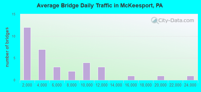
- 177,517Total average daily traffic
- 10,615Total average daily truck traffic
- National Bridge Inventory (NBI) Registered Bridges for McKeesport
- No street view available for this location
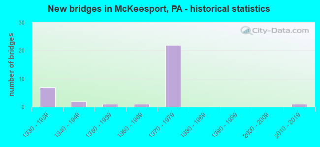
- New bridges - historical statistics
- 71930-1939
- 21940-1949
- 11950-1959
- 11960-1969
- 221970-1979
- 12010-2019
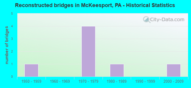
- Reconstructed bridges - Historical Statistics
- 11950-1959
- 01960-1969
- 41970-1979
- 11980-1989
- 01990-1999
- 12000-2009
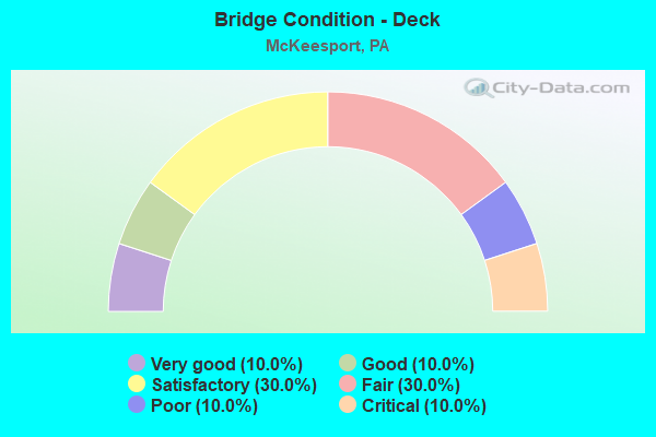
- Bridge Condition - Deck
- 10.0%Very good
- 10.0%Good
- 30.0%Satisfactory
- 30.0%Fair
- 10.0%Poor
- 10.0%Critical
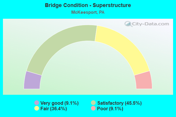
- Bridge Condition - Superstructure
- 9.1%Very good
- 45.5%Satisfactory
- 36.4%Fair
- 9.1%Poor
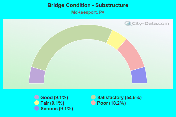
- Bridge Condition - Substructure
- 9.1%Good
- 54.5%Satisfactory
- 9.1%Fair
- 18.2%Poor
- 9.1%Serious
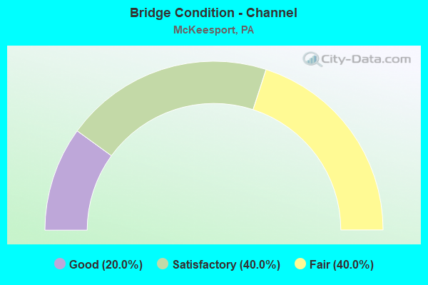
- Bridge Condition - Channel
- 20.0%Good
- 40.0%Satisfactory
- 40.0%Fair
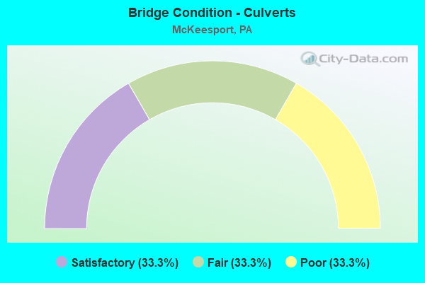
- Bridge Condition - Culverts
- 33.3%Satisfactory
- 33.3%Fair
- 33.3%Poor
Find on map >> Show street view
Structure Number: 29, Location: S.W. OF GETTYSBURG (Lat: 39.794747, Lng: -77.286597), Route carried "on" structure: State highway , Year Built: 1960, Status: Open, Structure Length: 0.67m (2.20ft), Average Daily Traffic: 726 (year 2022), Truck Traffic: 6%, Average Future Daily Traffic: 1,084 (year 2032), Design Load: HS 20, Features Intersected: TRIB MARSH CREEK, Facility Carried by Structure: SR 3005
Minimum Vertical Clearance: 30+ m (98+ ft), Kilometerpoint: 10.438, Lanes on structure: 2, Owner: State Highway Agency, Approaching Roadway Width: 7.3m (24.0ft), Skew: 1 degrees, Material/Design: Steel, Design/Construction: Culvert, Number Of Spans In Main Unit: 3, Length of Maximum Span: 1.8m (5.9ft), Curb or Sidewalk Widths: Left: 0.3m (1.0ft), Right: 0.0m
Condition: Channel: Good, Culverts: Poor, Operating Rating: 49.0 metric tons, Method Used To Determine Operating Rating: Load Factor (LF), Inventory Rating: 32.7 metric tons, Method Used To Determine Inventory Rating: Load Factor (LF), Structural Evaluation: Meets minimum limits, Waterway Adequacy: Meets minimum limits, Approach Roadway Alignment: Equal to present desirable criteria, Length Of Structure Improvement: 1.30m (4.27ft), Designated Inspection Frequency: Every 24 months, Other Special Inspection Frequency: Every 12 months, Inspection Date: December 2020, Other Special Inspection Date: December 2020
Find on map >> Show street view
Structure Number: 685, Location: 0.1 MI S OF SR 0048 (Lat: 40.323467, Lng: -79.838803), Route carried "on" structure: State highway 48, Year Built: 1934, Year Reconstructed: 1963, Status: Open, Structure Length: 0.76m (2.49ft), Average Daily Traffic: 9,499 (year 2020), Truck Traffic: 3%, Average Future Daily Traffic: 15,443 (year 2032), Design Load: HS 20, Features Intersected: LONG RUN
Minimum Vertical Clearance: 30+ m (98+ ft), Kilometerpoint: 12.638, Lanes on structure: 5, Base Highway Network: Yes, Owner: State Highway Agency, Approaching Roadway Width: 19.8m (65.0ft), Skew: 23 degrees, Material/Design: Masonry, Design/Construction: Culvert, Number Of Spans In Main Unit: 1, Length of Maximum Span: 7.6m (24.9ft)
Condition: Channel: Satisfactory, Culverts: Fair, Operating Rating: 49.0 metric tons, Method Used To Determine Operating Rating: Field evaluation and documented engineering judgment, Inventory Rating: 32.7 metric tons, Method Used To Determine Inventory Rating: Field evaluation and documented engineering judgment, Structural Evaluation: Somewhat better than minimum adequacy, Waterway Adequacy: Superior to present desirable criteria, Approach Roadway Alignment: Equal to present desirable criteria, Length Of Structure Improvement: 0.80m (2.62ft), Designated Inspection Frequency: Every 24 months, Inspection Date: March 2021, Bridge Improvement Cost: $13,000, Roadway Improvement Cost: $38,000, Total Project Cost: $174,000
Find on map >> Show street view
Structure Number: 964, Location: 200'S. OF S.INT.W/SR2037 (Lat: 40.357703, Lng: -79.832206), Route carried "on" structure: State highway 148, Year Built: 1950, Status: Open, Structure Length: 0.82m (2.69ft), Average Daily Traffic: 22,192 (year 2020), Truck Traffic: 5%, Average Future Daily Traffic: 25,027 (year 2032), Design Load: HS 20, Features Intersected: CROOKED RUN, Facility Carried by Structure: 5th AVENUE
Minimum Vertical Clearance: 30+ m (98+ ft), Kilometerpoint: 6.762, Lanes on structure: 3, Base Highway Network: Yes, Owner: State Highway Agency, Approaching Roadway Width: 12.2m (40.0ft), Skew: 4 degrees, Material/Design: Concrete, Design/Construction: Culvert, Number Of Spans In Main Unit: 1, Length of Maximum Span: 8.2m (26.9ft), Curb or Sidewalk Widths: Left: 2.1m (6.9ft), Right: 2.1m (6.9ft), Curb-To-Curb Width: 12.2m (40.0ft), Out-to-Out Width: 14.6m (47.9ft)
Condition: Channel: Satisfactory, Culverts: Satisfactory, Operating Rating: 49.0 metric tons, Method Used To Determine Operating Rating: Field evaluation and documented engineering judgment, Inventory Rating: 32.7 metric tons, Method Used To Determine Inventory Rating: Field evaluation and documented engineering judgment, Structural Evaluation: Equal to present minimum criteria, Deck Geometry: Meets minimum limits, Waterway Adequacy: Superior to present desirable criteria, Approach Roadway Alignment: Equal to present desirable criteria, Length Of Structure Improvement: 1.40m (4.59ft), Designated Inspection Frequency: Every 24 months, Inspection Date: Febuary 2021
Find on map >> Show street view
Structure Number: 965, Location: 150 FT N OF SR2037 (Lat: 40.358942, Lng: -79.831239), Route carried "on" structure: State highway 148, Year Built: 1937, Year Reconstructed: 2009, Status: Open, Structure Length: 0.79m (2.59ft), Average Daily Traffic: 18,182 (year 2022), Truck Traffic: 11%, Average Future Daily Traffic: 21,626 (year 2032), Design Load: HS 20, Features Intersected: CROOKED RUN, Facility Carried by Structure: 5TH AVE
Minimum Vertical Clearance: 30+ m (98+ ft), Kilometerpoint: 7.216, Lanes on structure: 4, Base Highway Network: Yes, Owner: State Highway Agency, Approaching Roadway Width: 13.4m (44.0ft), Skew: 3 degrees, Material/Design: Concrete, Design/Construction: Slab, Number Of Spans In Main Unit: 1, Length of Maximum Span: 7.3m (24.0ft), Curb or Sidewalk Widths: Left: 1.3m (4.3ft), Right: 1.2m (3.9ft), Curb-To-Curb Width: 13.4m (44.0ft), Out-to-Out Width: 17.1m (56.1ft)
Condition: Deck: Satisfactory, Superstructure: Satisfactory, Substructure: Satisfactory, Channel: Fair, Operating Rating: 83.5 metric tons, Method Used To Determine Operating Rating: Load Factor (LF), Inventory Rating: 49.9 metric tons, Method Used To Determine Inventory Rating: Load Factor (LF), Structural Evaluation: Equal to present minimum criteria, Deck Geometry: High priority of replacement, Waterway Adequacy: Equal to present minimum criteria, Approach Roadway Alignment: Equal to present desirable criteria, Length Of Structure Improvement: 0.80m (2.62ft), Designated Inspection Frequency: Every 24 months, Inspection Date: September 2021, Deck Structure Type: Concrete Cast-file-Place, Wearing Surface/Protective System: Wearing Surface: Monolithic Concrete, Deck Protection: Epoxy Coated Reinforcing
Find on map >> Show street view
Structure Number: 1651, Location: Jerome Street Bridge (Lat: 40.350403, Lng: -79.870144), Route carried "on" structure: Spur State highway , Year Built: 1937, Year Reconstructed: 1988, Status: Open, Structure Length: 23.20m (76.12ft), Average Daily Traffic: 11,232 (year 2022), Truck Traffic: 5%, Average Future Daily Traffic: 18,013 (year 2032), Design Load: HS 20, Features Intersected: 2027,CSX,LOCAL,& YOUGH R, Facility Carried by Structure: Jerome Street Brg
Minimum Vertical Clearance: 5.03m (16.50ft), Kilometerpoint: 0.000, Lanes on structure: 4, Lanes under structure: 8, Base Highway Network: Yes, Owner: State Highway Agency, Approaching Roadway Width: 12.2m (40.0ft), Navigation Control: Yes ( Vertical Clearance: 999.7m (3,279.9ft), Horizontal Clearance: 9999.9m (32,808.1ft)), Material/Design: Steel, Design/Construction: Arch - Thru, Number Of Spans In Main Unit: 1, Number Of Approach Spans: 5, Length of Maximum Span: 138.7m (455.1ft), Curb or Sidewalk Widths: Left: 2.4m (7.9ft), Right: 2.4m (7.9ft), Curb-To-Curb Width: 12.2m (40.0ft), Out-to-Out Width: 18.3m (60.0ft)
Condition: Deck: Poor, Superstructure: Fair, Substructure: Poor, Channel: Fair, Operating Rating: 45.4 metric tons, Method Used To Determine Operating Rating: Load Factor (LF), Inventory Rating: 27.2 metric tons, Method Used To Determine Inventory Rating: Load Factor (LF), Structural Evaluation: Meets minimum limits, Deck Geometry: High priority of replacement, Underclear: High priority of corrective action, Waterway Adequacy: Superior to present desirable criteria, Approach Roadway Alignment: Equal to present minimum criteria, Length Of Structure Improvement: 23.20m (76.12ft), Designated Inspection Frequency: Every 24 months, Critical Feature Inspection Frequency: Every 24 months, Underwater Inspection Frequency: Every 60 months, Other Special Inspection Frequency: Every 12 months, Inspection Date: September 2021, Critical Feature Inspection Date: September 2021, Underwater Inspection Date: September 2017, Other Special Inspection Date: September 2021, Bridge Improvement Cost: $178,000, Roadway Improvement Cost: $523,000, Total Project Cost: $2,397,000, Deck Structure Type: Concrete Cast-file-Place, Wearing Surface/Protective System: Wearing Surface: Bituminous
Find on map >> Show street view
Structure Number: 1666, Location: 800 FT S OF MCKEESPRT BR (Lat: 40.352522, Lng: -79.841492), Route carried "on" structure: Ramp State highway , Year Built: 1973, Year Reconstructed: 1983, Status: Open, Structure Length: 4.42m (14.50ft), Average Daily Traffic: 8,322 (year 2022), Truck Traffic: 3%, Average Future Daily Traffic: 8,791 (year 2032), Design Load: HS 20, Features Intersected: 5TH AVE, Facility Carried by Structure: S APPR McKEESPORT
Minimum Vertical Clearance: 30+ m (98+ ft), Kilometerpoint: 0.000, Lanes on structure: 1, Lanes under structure: 8, Base Highway Network: Yes, Owner: State Highway Agency, Approaching Roadway Width: 10.1m (33.1ft), Skew: 2 degrees, Material/Design: Steel, Design/Construction: Stringer/Multi-beam, Number Of Spans In Main Unit: 1, Number Of Approach Spans: 2, Length of Maximum Span: 25.9m (85.0ft), Curb or Sidewalk Widths: Left: 0.2m (0.7ft), Right: 0.2m (0.7ft), Curb-To-Curb Width: 9.8m (32.2ft), Out-to-Out Width: 11.0m (36.1ft)
Condition: Deck: Fair, Superstructure: Satisfactory, Substructure: Satisfactory, Operating Rating: 53.5 metric tons, Method Used To Determine Operating Rating: Load Factor (LF), Inventory Rating: 31.8 metric tons, Method Used To Determine Inventory Rating: Load Factor (LF), Structural Evaluation: Equal to present minimum criteria, Deck Geometry: Superior to present desirable criteria, Underclear: Meets minimum limits, Approach Roadway Alignment: Equal to present minimum criteria, Length Of Structure Improvement: 4.40m (14.44ft), Designated Inspection Frequency: Every 24 months, Inspection Date: August 2020, Bridge Improvement Cost: $19,000, Roadway Improvement Cost: $55,000, Total Project Cost: $252,000, Deck Structure Type: Concrete Cast-file-Place, Wearing Surface/Protective System: Wearing Surface: Latex Concrete
Find on map >> Show street view
Structure Number: 1667, Location: @ S.END OF MCKSPRT-DUQ BR (Lat: 40.354153, Lng: -79.842178), Route carried "on" structure: State highway , Year Built: 1973, Status: Open, Structure Length: 11.40m (37.40ft), Average Daily Traffic: 2,021 (year 2022), Truck Traffic: 8%, Average Future Daily Traffic: 8,519 (year 2032), Design Load: HS 20, Features Intersected: 1066,RAMP,G-E,CLIFF ST, Facility Carried by Structure: BOWMAN AV
Minimum Vertical Clearance: 30+ m (98+ ft), Kilometerpoint: 0.000, Lanes on structure: 1, Lanes under structure: 24, Owner: State Highway Agency, Approaching Roadway Width: 9.1m (29.9ft), Material/Design: Steel, Design/Construction: Stringer/Multi-beam, Number Of Spans In Main Unit: 1, Number Of Approach Spans: 4, Length of Maximum Span: 33.2m (108.9ft), Curb or Sidewalk Widths: Left: 0.2m (0.7ft), Right: 0.2m (0.7ft), Curb-To-Curb Width: 7.6m (24.9ft), Out-to-Out Width: 8.8m (28.9ft)
Condition: Deck: Satisfactory, Superstructure: Satisfactory, Substructure: Satisfactory, Operating Rating: 58.1 metric tons, Method Used To Determine Operating Rating: Load Factor (LF), Inventory Rating: 34.5 metric tons, Method Used To Determine Inventory Rating: Load Factor (LF), Structural Evaluation: Equal to present minimum criteria, Deck Geometry: High priority of replacement, Underclear: Somewhat better than minimum adequacy, Approach Roadway Alignment: Better than present minimum criteria, Length Of Structure Improvement: 10.60m (34.78ft), Designated Inspection Frequency: Every 24 months, Inspection Date: July 2020, Bridge Improvement Cost: $17,000, Roadway Improvement Cost: $49,000, Total Project Cost: $224,000, Deck Structure Type: Concrete Cast-file-Place, Wearing Surface/Protective System: Wearing Surface: Latex Concrete
Find on map >> Show street view
Structure Number: 2518, Location: 304004 RMP 2 IN MCKEESPRT (Lat: 40.347436, Lng: -79.881047), Route carried "on" structure: Ramp City street , Year Built: 1949, Status: Open, Structure Length: 2.53m (8.30ft), Average Daily Traffic: 3,300 (year 2005), Truck Traffic: 5%, Average Future Daily Traffic: 3,600 (year 2027), Design Load: HS 20+Mod, Features Intersected: CSX (3RIV)& PACIFIC AVE, Facility Carried by Structure: RAMP-TWO RD
Minimum Vertical Clearance: 30+ m (98+ ft), Kilometerpoint: 0.000, Lanes on structure: 2, Lanes under structure: 2, Owner: City or Municipal Highway Agency, Approaching Roadway Width: 7.9m (25.9ft), Skew: 3 degrees, Material/Design: Steel, Design/Construction: Girder and Floorbeam System, Number Of Spans In Main Unit: 2, Length of Maximum Span: 14.0m (45.9ft), Curb or Sidewalk Widths: Left: 2.1m (6.9ft), Right: 0.2m (0.7ft), Curb-To-Curb Width: 8.5m (27.9ft), Out-to-Out Width: 9.4m (30.8ft)
Condition: Deck: Fair, Superstructure: Fair, Substructure: Poor, Operating Rating: 46.3 metric tons, Method Used To Determine Operating Rating: Load Factor (LF), Inventory Rating: 28.1 metric tons, Method Used To Determine Inventory Rating: Load Factor (LF), Structural Evaluation: Meets minimum limits, Deck Geometry: High priority of corrective action, Underclear: Superior to present desirable criteria, Approach Roadway Alignment: Somewhat better than minimum adequacy, Length Of Structure Improvement: 2.50m (8.20ft), Designated Inspection Frequency: Every 24 months, Critical Feature Inspection Frequency: Every 24 months, Inspection Date: October 2019, Critical Feature Inspection Date: October 2019, Bridge Improvement Cost: $70,000, Roadway Improvement Cost: $206,000, Total Project Cost: $944,000, Deck Structure Type: Concrete Cast-file-Place, Wearing Surface/Protective System: Wearing Surface: Bituminous
Find on map >> Show street view
Structure Number: 2519, Location: 304005 VERSAILLES AVE VIA (Lat: 40.346308, Lng: -79.852692), Route carried "on" structure: City street , Year Built: 1972, Status: Posted for load, Structure Length: 8.66m (28.41ft), Average Daily Traffic: 14,000 (year 2005), Truck Traffic: 10%, Average Future Daily Traffic: 15,400 (year 2026), Design Load: HS 20, Features Intersected: RAVINE STREET, Facility Carried by Structure: VERSAILLES AV
Minimum Vertical Clearance: 30+ m (98+ ft), Kilometerpoint: 0.000, Lanes on structure: 2, Lanes under structure: 2, Owner: City or Municipal Highway Agency, Approaching Roadway Width: 9.1m (29.9ft), Material/Design: Steel, Design/Construction: Stringer/Multi-beam, Number Of Spans In Main Unit: 3, Length of Maximum Span: 28.0m (91.9ft), Curb or Sidewalk Widths: Left: 1.7m (5.6ft), Right: 1.7m (5.6ft), Curb-To-Curb Width: 8.1m (26.6ft), Out-to-Out Width: 11.4m (37.4ft)
Condition: Deck: Critical, Superstructure: Fair, Substructure: Serious, Operating Rating: 19.1 metric tons, Method Used To Determine Operating Rating: Load Factor (LF), Inventory Rating: 11.8 metric tons, Method Used To Determine Inventory Rating: Load Factor (LF), Structural Evaluation: High priority of corrective action, Deck Geometry: High priority of corrective action, Underclear: Superior to present desirable criteria, Approach Roadway Alignment: Equal to present desirable criteria, Bridge Posting: Required (Relationship of Operating Rating to Maximum Legal Load: > 39.9% below), Length Of Structure Improvement: 9.10m (29.86ft), Designated Inspection Frequency: Every 24 months, Other Special Inspection Frequency: Every 6 months, Inspection Date: October 2020, Other Special Inspection Date: October 2021, Bridge Improvement Cost: $17,000, Roadway Improvement Cost: $50,000, Total Project Cost: $224,000, Deck Structure Type: Concrete Cast-file-Place, Wearing Surface/Protective System: Wearing Surface: Bituminous, Deck Protection: Epoxy Coated Reinforcing
Find on map >> Show street view
Structure Number: 2897, Location: 300' S. OF MCKEES.-DUQ.BR (Lat: 40.352608, Lng: -79.842797), Route carried "on" structure: Ramp State highway , Year Built: 1972, Year Reconstructed: 1983, Status: Open, Structure Length: 27.22m (89.30ft), Average Daily Traffic: 4,148 (year 2022), Truck Traffic: 7%, Average Future Daily Traffic: 11,046 (year 2032), Design Load: HS 20, Features Intersected: LOCAL STREETS, Facility Carried by Structure: RAMP F
Minimum Vertical Clearance: 30+ m (98+ ft), Kilometerpoint: 0.000, Lanes on structure: 2, Lanes under structure: 60, Base Highway Network: Yes, Owner: State Highway Agency, Approaching Roadway Width: 11.3m (37.1ft), Skew: 9 degrees, Material/Design: Steel continuous, Design/Construction: Girder and Floorbeam System, Number Of Spans In Main Unit: 2, Number Of Approach Spans: 9, Length of Maximum Span: 34.1m (111.9ft), Curb or Sidewalk Widths: Left: 0.2m (0.7ft), Right: 0.2m (0.7ft), Curb-To-Curb Width: 10.4m (34.1ft), Out-to-Out Width: 11.6m (38.1ft)
Condition: Deck: Good, Superstructure: Satisfactory, Substructure: Satisfactory, Operating Rating: 49.9 metric tons, Method Used To Determine Operating Rating: Load Factor (LF), Inventory Rating: 29.9 metric tons, Method Used To Determine Inventory Rating: Load Factor (LF), Structural Evaluation: Equal to present minimum criteria, Deck Geometry: Better than present minimum criteria, Underclear: High priority of corrective action, Approach Roadway Alignment: Somewhat better than minimum adequacy, Length Of Structure Improvement: 27.20m (89.24ft), Designated Inspection Frequency: Every 24 months, Critical Feature Inspection Frequency: Every 24 months, Inspection Date: August 2020, Critical Feature Inspection Date: August 2020, Bridge Improvement Cost: $17,000, Roadway Improvement Cost: $51,000, Total Project Cost: $233,000, Deck Structure Type: Concrete Cast-file-Place, Wearing Surface/Protective System: Wearing Surface: Latex Concrete, Membrane: Other
Find on map >> Show street view
Structure Number: 2898, Location: S APPR. MCKEESPORT-DUQ (Lat: 40.354236, Lng: -79.843014), Route carried "on" structure: Ramp State highway , Year Built: 1935, Status: Open, Structure Length: 1.07m (3.51ft), Average Daily Traffic: 2,670 (year 2022), Truck Traffic: 7%, Average Future Daily Traffic: 6,709 (year 2032), Design Load: HS 20, Features Intersected: CLIFF STREET, Facility Carried by Structure: RAMP H
Minimum Vertical Clearance: 30+ m (98+ ft), Kilometerpoint: 0.000, Lanes on structure: 1, Lanes under structure: 2, Base Highway Network: Yes, Owner: State Highway Agency, Approaching Roadway Width: 7.0m (23.0ft), Skew: 1 degrees, Material/Design: Concrete, Design/Construction: Frame, Number Of Spans In Main Unit: 1, Length of Maximum Span: 9.8m (32.2ft), Curb or Sidewalk Widths: Left: 0.0m, Right: 2.1m (6.9ft), Curb-To-Curb Width: 7.0m (23.0ft), Out-to-Out Width: 16.8m (55.1ft)
Condition: Superstructure: Poor, Substructure: Fair, Operating Rating: 49.0 metric tons, Method Used To Determine Operating Rating: Field evaluation and documented engineering judgment, Inventory Rating: 32.7 metric tons, Method Used To Determine Inventory Rating: Field evaluation and documented engineering judgment, Structural Evaluation: Meets minimum limits, Deck Geometry: Equal to present minimum criteria, Underclear: Meets minimum limits, Approach Roadway Alignment: Equal to present desirable criteria, Length Of Structure Improvement: 1.10m (3.61ft), Designated Inspection Frequency: Every 24 months, Inspection Date: August 2020, Bridge Improvement Cost: $49,000, Roadway Improvement Cost: $143,000, Total Project Cost: $657,000
Find on map >> Show street view
Structure Number: 2899, Location: 1066 RAMP G OVER LR1066 (Lat: 40.350000, Lng: -79.841667), Route carried "on" structure: Ramp State highway , Year Built: 1973, Year Reconstructed: 1983, Status: Open, Structure Length: 5.03m (16.50ft), Average Daily Traffic: 1,470 (year 2022), Truck Traffic: 7%, Average Future Daily Traffic: 6,905 (year 2032), Design Load: HS 20, Features Intersected: SR 2114 NB SB, Facility Carried by Structure: RAMP G
Minimum Vertical Clearance: 30+ m (98+ ft), Kilometerpoint: 0.000, Lanes on structure: 1, Lanes under structure: 4, Base Highway Network: Yes, Owner: State Highway Agency, Approaching Roadway Width: 11.0m (36.1ft), Skew: 3 degrees, Material/Design: Steel continuous, Design/Construction: Girder and Floorbeam System, Number Of Spans In Main Unit: 3, Length of Maximum Span: 20.7m (67.9ft), Curb or Sidewalk Widths: Left: 0.2m (0.7ft), Right: 0.2m (0.7ft), Curb-To-Curb Width: 10.4m (34.1ft), Out-to-Out Width: 11.6m (38.1ft)
Condition: Deck: Satisfactory, Superstructure: Satisfactory, Substructure: Satisfactory, Operating Rating: 41.7 metric tons, Method Used To Determine Operating Rating: Load Factor (LF), Inventory Rating: 24.5 metric tons, Method Used To Determine Inventory Rating: Load Factor (LF), Structural Evaluation: Equal to present minimum criteria, Deck Geometry: Superior to present desirable criteria, Underclear: Somewhat better than minimum adequacy, Approach Roadway Alignment: Equal to present minimum criteria, Length Of Structure Improvement: 6.00m (19.69ft), Designated Inspection Frequency: Every 24 months, Critical Feature Inspection Frequency: Every 24 months, Inspection Date: August 2020, Critical Feature Inspection Date: August 2020, Bridge Improvement Cost: $28,000, Roadway Improvement Cost: $82,000, Total Project Cost: $376,000, Deck Structure Type: Concrete Cast-file-Place, Wearing Surface/Protective System: Wearing Surface: Latex Concrete
Find on map >> Show street view
Structure Number: 29, Location: RAMP G OVER 1066 RAMP E (Lat: 40.353961, Lng: -79.841164), Route carried "on" structure: Ramp State highway , Year Built: 1973, Year Reconstructed: 1983, Status: Open, Structure Length: 3.84m (12.60ft), Average Daily Traffic: 1,470 (year 2022), Truck Traffic: 7%, Average Future Daily Traffic: 6,905 (year 2032), Design Load: HS 20, Features Intersected: RAMP E, Facility Carried by Structure: RAMP G
Minimum Vertical Clearance: 30+ m (98+ ft), Kilometerpoint: 0.000, Lanes on structure: 1, Lanes under structure: 1, Base Highway Network: Yes, Owner: State Highway Agency, Approaching Roadway Width: 10.1m (33.1ft), Skew: 3 degrees, Material/Design: Steel continuous, Design/Construction: Stringer/Multi-beam, Number Of Spans In Main Unit: 3, Length of Maximum Span: 16.2m (53.1ft), Curb or Sidewalk Widths: Left: 0.2m (0.7ft), Right: 0.2m (0.7ft), Curb-To-Curb Width: 9.1m (29.9ft), Out-to-Out Width: 10.4m (34.1ft)
Condition: Deck: Fair, Superstructure: Fair, Substructure: Satisfactory, Operating Rating: 58.1 metric tons, Method Used To Determine Operating Rating: Load Factor (LF), Inventory Rating: 34.5 metric tons, Method Used To Determine Inventory Rating: Load Factor (LF), Structural Evaluation: Somewhat better than minimum adequacy, Deck Geometry: Superior to present desirable criteria, Underclear: Somewhat better than minimum adequacy, Approach Roadway Alignment: Better than present minimum criteria, Length Of Structure Improvement: 4.60m (15.09ft), Designated Inspection Frequency: Every 24 months, Inspection Date: August 2020, Bridge Improvement Cost: $11,000, Roadway Improvement Cost: $34,000, Total Project Cost: $153,000, Deck Structure Type: Concrete Cast-file-Place, Wearing Surface/Protective System: Wearing Surface: Latex Concrete
Find on map >> Show street view
Structure Number: 46801, Location: FO03 MCKEESPORT FLYOVER (Lat: 40.352911, Lng: -79.856842), Route carried "on" structure: City street , Year Built: 2011, Status: Open, Structure Length: 3.08m (10.10ft), Average Daily Traffic: 500 (year 2011), Truck Traffic: 5%, Average Future Daily Traffic: 3,782 (year 2029), Design Load: HL 93, Features Intersected: CSX & UNION RR, Facility Carried by Structure: COURSIN STREET
Minimum Vertical Clearance: 30+ m (98+ ft), Kilometerpoint: 0.000, Lanes on structure: 2, Owner: County Highway Agency, Approaching Roadway Width: 12.2m (40.0ft), Material/Design: Steel, Design/Construction: Stringer/Multi-beam, Number Of Spans In Main Unit: 1, Length of Maximum Span: 29.9m (98.1ft), Curb or Sidewalk Widths: Left: 2.1m (6.9ft), Right: 0.2m (0.7ft), Curb-To-Curb Width: 12.2m (40.0ft), Out-to-Out Width: 15.1m (49.5ft)
Condition: Deck: Very good, Superstructure: Very good, Substructure: Good, Operating Rating: 48.3 metric tons, Method Used To Determine Operating Rating: Assigned ratings based on Load and Resistance Factor Design (LRFD) reported by rating factor (RF) using HL93 loadings, Inventory Rating: 37.3 metric tons, Method Used To Determine Inventory Rating: Assigned ratings based on Load and Resistance Factor Design (LRFD) reported by rating factor (RF) using HL93 loadings, Structural Evaluation: Better than present minimum criteria, Deck Geometry: Equal to present desirable criteria, Approach Roadway Alignment: Equal to present minimum criteria, Designated Inspection Frequency: Every 24 months, Inspection Date: October 2021, Deck Structure Type: Concrete Cast-file-Place, Wearing Surface/Protective System: Wearing Surface: Monolithic Concrete, Deck Protection: Epoxy Coated Reinforcing
Find on map >> Show street view
Structure Number: 1651, Location: Jerome Street Bridge (Lat: 40.350403, Lng: -79.870144), Route carried "under" structure: State highway , Year Built: 1937, Structure Length: 0. m, Average Daily Traffic: 932 (year 2022), Truck Traffic: 7%, Features Intersected: 2027,CSX,LOCAL,& YOUGH R, Facility Carried by Structure: Jerome Street Brg
Minimum Vertical Clearance: 14.63m (48.00ft), Kilometerpoint: 3.304, Lanes on structure: 4, Lanes under structure: 4, Material/Design: Steel, Design/Construction: Arch - Thru, Length of Maximum Span: 138.7m (455.1ft)
Find on map >> Show street view
Structure Number: 1651, Location: Jerome Street Bridge (Lat: 40.350403, Lng: -79.870144), Route carried "under" structure: City street , Year Built: 1937, Structure Length: 0. m, Average Daily Traffic: 200 (year 1997), Truck Traffic: 5%, Features Intersected: 2027,CSX,LOCAL,& YOUGH R, Facility Carried by Structure: Jerome Street Brg
Minimum Vertical Clearance: 4.60m (15.09ft), Kilometerpoint: 0.000, Lanes on structure: 4, Lanes under structure: 4, Material/Design: Steel, Design/Construction: Arch - Thru, Length of Maximum Span: 138.7m (455.1ft)
Find on map >> Show street view
Structure Number: 1666, Location: 800 FT S OF MCKEESPRT BR (Lat: 40.352522, Lng: -79.841492), Route carried "under" structure: State highway 148, Year Built: 1973, Structure Length: 0. m, Average Daily Traffic: 4,242 (year 2021), Truck Traffic: 6%, Features Intersected: 5TH AVE, Facility Carried by Structure: S APPR McKEESPORT
Minimum Vertical Clearance: 4.40m (14.44ft), Kilometerpoint: 6.096, Lanes on structure: 1, Lanes under structure: 4, Material/Design: Steel, Design/Construction: Stringer/Multi-beam, Length of Maximum Span: 25.9m (85.0ft)
Find on map >> Show street view
Structure Number: 1666, Location: 800 FT S OF MCKEESPRT BR (Lat: 40.352522, Lng: -79.841492), Route carried "under" structure: State highway 148, Year Built: 1973, Structure Length: 0. m, Average Daily Traffic: 3,655 (year 2021), Truck Traffic: 5%, Features Intersected: 5TH AVE, Facility Carried by Structure: S APPR McKEESPORT
Minimum Vertical Clearance: 4.71m (15.45ft), Kilometerpoint: 6.085, Lanes on structure: 1, Lanes under structure: 4, Material/Design: Steel, Design/Construction: Stringer/Multi-beam, Length of Maximum Span: 25.9m (85.0ft)
Find on map >> Show street view
Structure Number: 1667, Location: @ S.END OF MCKSPRT-DUQ BR (Lat: 40.354153, Lng: -79.842178), Route carried "under" structure: Ramp State highway , Year Built: 1973, Structure Length: 0. m, Average Daily Traffic: 2,684 (year 2022), Truck Traffic: 7%, Features Intersected: 1066,RAMP,G-E,CLIFF ST, Facility Carried by Structure: BOWMAN AV
Minimum Vertical Clearance: 4.34m (14.24ft), Kilometerpoint: 0.000, Lanes on structure: 1, Lanes under structure: 6, Material/Design: Steel, Design/Construction: Stringer/Multi-beam, Length of Maximum Span: 33.2m (108.9ft)
Find on map >> Show street view
Structure Number: 1667, Location: @ S.END OF MCKSPRT-DUQ BR (Lat: 40.354153, Lng: -79.842178), Route carried "under" structure: State highway , Year Built: 1973, Structure Length: 0. m, Average Daily Traffic: 11,045 (year 2022), Truck Traffic: 7%, Features Intersected: 1066,RAMP,G-E,CLIFF ST, Facility Carried by Structure: BOWMAN AV
Minimum Vertical Clearance: 10.67m (35.01ft), Kilometerpoint: 0.000, Lanes on structure: 1, Lanes under structure: 6, Material/Design: Steel, Design/Construction: Stringer/Multi-beam, Length of Maximum Span: 33.2m (108.9ft)
Find on map >> Show street view
Structure Number: 1667, Location: @ S.END OF MCKSPRT-DUQ BR (Lat: 40.354153, Lng: -79.842178), Route carried "under" structure: State highway , Year Built: 1973, Structure Length: 0. m, Average Daily Traffic: 11,044 (year 2022), Truck Traffic: 7%, Features Intersected: 1066,RAMP,G-E,CLIFF ST, Facility Carried by Structure: BOWMAN AV
Minimum Vertical Clearance: 10.67m (35.01ft), Kilometerpoint: 0.000, Lanes on structure: 1, Lanes under structure: 6, Material/Design: Steel, Design/Construction: Stringer/Multi-beam, Length of Maximum Span: 33.2m (108.9ft)
Find on map >> Show street view
Structure Number: 1667, Location: @ S.END OF MCKSPRT-DUQ BR (Lat: 40.354153, Lng: -79.842178), Route carried "under" structure: Ramp State highway , Year Built: 1973, Structure Length: 0. m, Average Daily Traffic: 1,470 (year 2022), Truck Traffic: 7%, Features Intersected: 1066,RAMP,G-E,CLIFF ST, Facility Carried by Structure: BOWMAN AV
Minimum Vertical Clearance: 4.88m (16.01ft), Kilometerpoint: 0.000, Lanes on structure: 1, Lanes under structure: 6, Material/Design: Steel, Design/Construction: Stringer/Multi-beam, Length of Maximum Span: 33.2m (108.9ft)
Find on map >> Show street view
Structure Number: 2518, Location: 304004 RMP 2 IN MCKEESPRT (Lat: 40.347436, Lng: -79.881047), Route carried "under" structure: City street , Year Built: 1949, Structure Length: 0. m, Average Daily Traffic: 1,000 (year 2005), Truck Traffic: 5%, Features Intersected: CSX (3RIV)& PACIFIC AVE, Facility Carried by Structure: RAMP-TWO RD
Minimum Vertical Clearance: 5.77m (18.93ft), Kilometerpoint: 0.000, Lanes on structure: 2, Lanes under structure: 2, Material/Design: Steel, Design/Construction: Girder and Floorbeam System, Length of Maximum Span: 14.0m (45.9ft)
Find on map >> Show street view
Structure Number: 2519, Location: 304005 VERSAILLES AVE VIA (Lat: 40.346308, Lng: -79.852692), Route carried "under" structure: City street , Year Built: 1972, Structure Length: 0. m, Average Daily Traffic: 50 (year 2005), Features Intersected: RAVINE STREET, Facility Carried by Structure: VERSAILLES AV
Minimum Vertical Clearance: 11.68m (38.32ft), Kilometerpoint: 0.000, Lanes on structure: 2, Lanes under structure: 2, Material/Design: Steel, Design/Construction: Stringer/Multi-beam, Length of Maximum Span: 28.0m (91.9ft)
Find on map >> Show street view
Structure Number: 2897, Location: 300' S. OF MCKEES.-DUQ.BR (Lat: 40.352608, Lng: -79.842797), Route carried "under" structure: City street , Year Built: 1972, Structure Length: 0. m, Average Daily Traffic: 50 (year 2005), Truck Traffic: 1%, Features Intersected: LOCAL STREETS, Facility Carried by Structure: RAMP F
Minimum Vertical Clearance: 4.42m (14.50ft), Kilometerpoint: 0.000, Lanes on structure: 2, Lanes under structure: 10, Material/Design: Steel continuous, Design/Construction: Girder and Floorbeam System, Length of Maximum Span: 34.1m (111.9ft)
Find on map >> Show street view
Structure Number: 2897, Location: 300' S. OF MCKEES.-DUQ.BR (Lat: 40.352608, Lng: -79.842797), Route carried "under" structure: State highway , Year Built: 1972, Structure Length: 0. m, Average Daily Traffic: 7,019 (year 2022), Truck Traffic: 3%, Features Intersected: LOCAL STREETS, Facility Carried by Structure: RAMP F
Minimum Vertical Clearance: 4.63m (15.19ft), Kilometerpoint: 0.000, Lanes on structure: 2, Lanes under structure: 10, Material/Design: Steel continuous, Design/Construction: Girder and Floorbeam System, Length of Maximum Span: 34.1m (111.9ft)
Find on map >> Show street view
Structure Number: 2897, Location: 300' S. OF MCKEES.-DUQ.BR (Lat: 40.352608, Lng: -79.842797), Route carried "under" structure: State highway 148, Year Built: 1972, Structure Length: 0. m, Average Daily Traffic: 3,655 (year 2021), Truck Traffic: 5%, Features Intersected: LOCAL STREETS, Facility Carried by Structure: RAMP F
Minimum Vertical Clearance: 9.14m (29.99ft), Kilometerpoint: 5.753, Lanes on structure: 2, Lanes under structure: 10, Material/Design: Steel continuous, Design/Construction: Girder and Floorbeam System, Length of Maximum Span: 34.1m (111.9ft)
Find on map >> Show street view
Structure Number: 2897, Location: 300' S. OF MCKEES.-DUQ.BR (Lat: 40.352608, Lng: -79.842797), Route carried "under" structure: State highway , Year Built: 1972, Structure Length: 0. m, Average Daily Traffic: 8,322 (year 2022), Truck Traffic: 3%, Features Intersected: LOCAL STREETS, Facility Carried by Structure: RAMP F
Minimum Vertical Clearance: 4.36m (14.30ft), Kilometerpoint: 0.000, Lanes on structure: 2, Lanes under structure: 10, Material/Design: Steel continuous, Design/Construction: Girder and Floorbeam System, Length of Maximum Span: 34.1m (111.9ft)
Find on map >> Show street view
Structure Number: 2897, Location: 300' S. OF MCKEES.-DUQ.BR (Lat: 40.352608, Lng: -79.842797), Route carried "under" structure: City street , Year Built: 1972, Structure Length: 0. m, Average Daily Traffic: 100 (year 2005), Truck Traffic: 1%, Features Intersected: LOCAL STREETS, Facility Carried by Structure: RAMP F
Minimum Vertical Clearance: 9.14m (29.99ft), Kilometerpoint: 0.000, Lanes on structure: 2, Lanes under structure: 10, Material/Design: Steel continuous, Design/Construction: Girder and Floorbeam System, Length of Maximum Span: 34.1m (111.9ft)
Find on map >> Show street view
Structure Number: 2897, Location: 300' S. OF MCKEES.-DUQ.BR (Lat: 40.352608, Lng: -79.842797), Route carried "under" structure: State highway 148, Year Built: 1972, Structure Length: 0. m, Average Daily Traffic: 4,242 (year 2021), Truck Traffic: 6%, Features Intersected: LOCAL STREETS, Facility Carried by Structure: RAMP F
Minimum Vertical Clearance: 9.14m (29.99ft), Kilometerpoint: 5.741, Lanes on structure: 2, Lanes under structure: 10, Material/Design: Steel continuous, Design/Construction: Girder and Floorbeam System, Length of Maximum Span: 34.1m (111.9ft)
Find on map >> Show street view
Structure Number: 2898, Location: S APPR. MCKEESPORT-DUQ (Lat: 40.354236, Lng: -79.843014), Route carried "under" structure: City street , Year Built: 1935, Structure Length: 0. m, Average Daily Traffic: 50 (year 1998), Truck Traffic: 1%, Features Intersected: CLIFF STREET, Facility Carried by Structure: RAMP H
Minimum Vertical Clearance: 4.47m (14.67ft), Kilometerpoint: 0.000, Lanes on structure: 1, Lanes under structure: 2, Material/Design: Concrete, Design/Construction: Frame, Length of Maximum Span: 9.8m (32.2ft)
Find on map >> Show street view
Structure Number: 2899, Location: 1066 RAMP G OVER LR1066 (Lat: 40.350000, Lng: -79.841667), Route carried "under" structure: State highway , Year Built: 1973, Structure Length: 0. m, Average Daily Traffic: 8,322 (year 2022), Truck Traffic: 3%, Features Intersected: SR 2114 NB SB, Facility Carried by Structure: RAMP G
Minimum Vertical Clearance: 6.25m (20.51ft), Kilometerpoint: 0.000, Lanes on structure: 1, Lanes under structure: 2, Material/Design: Steel continuous, Design/Construction: Girder and Floorbeam System, Length of Maximum Span: 20.7m (67.9ft)
Find on map >> Show street view
Structure Number: 2899, Location: 1066 RAMP G OVER LR1066 (Lat: 40.350000, Lng: -79.841667), Route carried "under" structure: State highway , Year Built: 1973, Structure Length: 0. m, Average Daily Traffic: 7,019 (year 2022), Truck Traffic: 3%, Features Intersected: SR 2114 NB SB, Facility Carried by Structure: RAMP G
Minimum Vertical Clearance: 6.71m (22.01ft), Kilometerpoint: 0.000, Lanes on structure: 1, Lanes under structure: 2, Material/Design: Steel continuous, Design/Construction: Girder and Floorbeam System, Length of Maximum Span: 20.7m (67.9ft)
Find on map >> Show street view
Structure Number: 29, Location: RAMP G OVER 1066 RAMP E (Lat: 40.353961, Lng: -79.841164), Route carried "under" structure: Ramp State highway , Year Built: 1973, Structure Length: 0. m, Average Daily Traffic: 2,684 (year 2022), Truck Traffic: 7%, Features Intersected: RAMP E, Facility Carried by Structure: RAMP G
Minimum Vertical Clearance: 4.40m (14.44ft), Kilometerpoint: 0.000, Lanes on structure: 1, Lanes under structure: 1, Material/Design: Steel continuous, Design/Construction: Stringer/Multi-beam, Length of Maximum Span: 16.2m (53.1ft)