Bridge Statistics for McRae, Arkansas (AR)
Condition, Traffic, Stress, Structural Evaluation, Project Costs
- National Bridge Inventory (NBI) Statistics
- 15Number of bridges
- 102ft / 31.4mTotal length
- $596,000Total costs
- 38,410Total average daily traffic
- 755Total average daily truck traffic
- National Bridge Inventory (NBI) Registered Bridges for McRae
- No street view available for this location
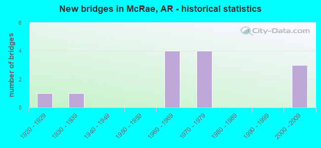
- New bridges - historical statistics
- 11920-1929
- 11930-1939
- 41960-1969
- 41970-1979
- 32000-2009


- Bridge Condition - Deck
- 33.3%Good
- 66.7%Satisfactory

- Bridge Condition - Superstructure
- 33.3%Good
- 50.0%Satisfactory
- 16.7%Fair

- Bridge Condition - Substructure
- 50.0%Good
- 50.0%Satisfactory

- Bridge Condition - Channel
- 16.7%Very good
- 58.3%Good
- 16.7%Satisfactory
- 8.3%Fair

- Bridge Condition - Culverts
- 71.4%Good
- 14.3%Satisfactory
- 14.3%Poor
Find on map >> Show street view
Structure Number: 1446, Location: 065 M S JCT37-367 (Lat: 35.108850, Lng: -91.828639), Route carried "on" structure: State highway 367, Year Built: 1930, Status: Open, Structure Length: 1.49m (4.89ft), Average Daily Traffic: 1,900 (year 2018), Truck Traffic: 1%, Average Future Daily Traffic: 3,117 (year 2028), Design Load: H 15, Features Intersected: LAWRENCE BAYOU
Minimum Vertical Clearance: 30+ m (98+ ft), Kilometerpoint: 12.920, Lanes on structure: 2, Owner: State Highway Agency, Approaching Roadway Width: 7.3m (24.0ft), Material/Design: Concrete, Design/Construction: Tee Beam, Number Of Spans In Main Unit: 2, Length of Maximum Span: 7.3m (24.0ft), Curb or Sidewalk Widths: Left: 0.2m (0.7ft), Right: 0.2m (0.7ft), Curb-To-Curb Width: 8.2m (26.9ft), Out-to-Out Width: 9.1m (29.9ft)
Condition: Deck: Good, Superstructure: Good, Substructure: Good, Channel: Very good, Operating Rating: 53.5 metric tons, Method Used To Determine Operating Rating: Load Factor (LF), Inventory Rating: 32.7 metric tons, Method Used To Determine Inventory Rating: Load Factor (LF), Structural Evaluation: Better than present minimum criteria, Deck Geometry: Meets minimum limits, Waterway Adequacy: Better than present minimum criteria, Approach Roadway Alignment: Equal to present desirable criteria, Length Of Structure Improvement: 2.23m (7.32ft), Designated Inspection Frequency: Every 24 months, Critical Feature Inspection Frequency: Every 24 months, Inspection Date: August 2021, Roadway Improvement Cost: $125,000, Total Project Cost: $281,000, Deck Structure Type: Concrete Cast-file-Place, Wearing Surface/Protective System: Wearing Surface: Bituminous
Find on map >> Show street view
Structure Number: 3759, Location: .4 MI W JCT SH 27 (Lat: 34.652719, Lng: -93.540181), Route carried "on" structure: State highway 88, Year Built: 1966, Status: Open, Structure Length: 2.74m (8.99ft), Average Daily Traffic: 250 (year 2018), Truck Traffic: 1%, Average Future Daily Traffic: 393 (year 2028), Design Load: H 15, Features Intersected: Deer Creek
Minimum Vertical Clearance: 30+ m (98+ ft), Kilometerpoint: 42.422, Lanes on structure: 2, Owner: State Highway Agency, Approaching Roadway Width: 6.1m (20.0ft), Skew: 4 degrees, Material/Design: Concrete, Design/Construction: Slab, Number Of Spans In Main Unit: 3, Length of Maximum Span: 9.1m (29.9ft), Curb or Sidewalk Widths: Left: 0.2m (0.7ft), Right: 0.2m (0.7ft), Curb-To-Curb Width: 7.3m (24.0ft), Out-to-Out Width: 8.7m (28.5ft)
Condition: Deck: Satisfactory, Superstructure: Satisfactory, Substructure: Satisfactory, Channel: Good, Operating Rating: 39.9 metric tons, Method Used To Determine Operating Rating: Load Factor (LF), Inventory Rating: 24.5 metric tons, Method Used To Determine Inventory Rating: Load Factor (LF), Structural Evaluation: Equal to present minimum criteria, Deck Geometry: Somewhat better than minimum adequacy, Waterway Adequacy: Equal to present desirable criteria, Approach Roadway Alignment: Better than present minimum criteria, Designated Inspection Frequency: Every 24 months, Critical Feature Inspection Frequency: Every 24 months, Inspection Date: November 2021, Deck Structure Type: Concrete Cast-file-Place, Wearing Surface/Protective System: Wearing Surface: Bituminous
Find on map >> Show street view
Structure Number: 3983, Location: 2.75 MI NE JCT SH 31 &267 (Lat: 35.143519, Lng: -91.871097), Route carried "on" structure: State highway 267, Year Built: 1966, Status: Open, Structure Length: 3.05m (10.01ft), Average Daily Traffic: 1,300 (year 2018), Truck Traffic: 1%, Average Future Daily Traffic: 1,491 (year 2028), Design Load: H 15, Features Intersected: LITTLE CANE CREEK
Minimum Vertical Clearance: 30+ m (98+ ft), Kilometerpoint: 4.426, Lanes on structure: 2, Owner: State Highway Agency, Approaching Roadway Width: 6.1m (20.0ft), Material/Design: Concrete, Design/Construction: Slab, Number Of Spans In Main Unit: 4, Length of Maximum Span: 7.6m (24.9ft), Curb or Sidewalk Widths: Left: 0.5m (1.6ft), Right: 0.5m (1.6ft), Curb-To-Curb Width: 7.3m (24.0ft), Out-to-Out Width: 9.1m (29.9ft)
Condition: Deck: Satisfactory, Superstructure: Satisfactory, Substructure: Good, Channel: Good, Operating Rating: 42.6 metric tons, Method Used To Determine Operating Rating: Load Factor (LF), Inventory Rating: 25.4 metric tons, Method Used To Determine Inventory Rating: Load Factor (LF), Structural Evaluation: Equal to present minimum criteria, Deck Geometry: Meets minimum limits, Waterway Adequacy: Equal to present desirable criteria, Approach Roadway Alignment: Equal to present desirable criteria, Designated Inspection Frequency: Every 24 months, Critical Feature Inspection Frequency: Every 24 months, Inspection Date: April 2020, Deck Structure Type: Concrete Cast-file-Place, Wearing Surface/Protective System: Wearing Surface: Monolithic Concrete
Find on map >> Show street view
Structure Number: 5356, Location: 1.20 MI N JCT SH 367 (Lat: 35.131950, Lng: -91.820331), Route carried "on" structure: State highway 13, Year Built: 1973, Status: Open, Structure Length: 10.45m (34.28ft), Average Daily Traffic: 1,500 (year 2018), Truck Traffic: 1%, Average Future Daily Traffic: 1,762 (year 2028), Design Load: H 20, Features Intersected: US 67-SEC 12
Minimum Vertical Clearance: 30+ m (98+ ft), Kilometerpoint: 1.931, Lanes on structure: 2, Lanes under structure: 4, Owner: State Highway Agency, Approaching Roadway Width: 13.4m (44.0ft), Skew: 3 degrees, Material/Design: Steel continuous, Design/Construction: Stringer/Multi-beam, Number Of Spans In Main Unit: 4, Length of Maximum Span: 33.8m (110.9ft), Curb or Sidewalk Widths: Left: 0.1m (0.3ft), Right: 0.1m (0.3ft), Curb-To-Curb Width: 8.5m (27.9ft), Out-to-Out Width: 9.4m (30.8ft)
Condition: Deck: Satisfactory, Superstructure: Satisfactory, Substructure: Satisfactory, Operating Rating: 54.4 metric tons, Method Used To Determine Operating Rating: Load Factor (LF), Inventory Rating: 32.7 metric tons, Method Used To Determine Inventory Rating: Load Factor (LF), Structural Evaluation: Equal to present minimum criteria, Deck Geometry: Somewhat better than minimum adequacy, Underclear: Better than present minimum criteria, Approach Roadway Alignment: Equal to present desirable criteria, Designated Inspection Frequency: Every 24 months, Critical Feature Inspection Frequency: Every 24 months, Inspection Date: March 2020, Deck Structure Type: Concrete Cast-file-Place, Wearing Surface/Protective System: Wearing Surface: Monolithic Concrete
Find on map >> Show street view
Structure Number: 6702, Location: 0.1 MI W OF ADONA (Lat: 35.038169, Lng: -92.903561), Route carried "on" structure: State highway 10, Year Built: 2000, Status: Open, Structure Length: 5.06m (16.60ft), Average Daily Traffic: 1,700 (year 2018), Truck Traffic: 22%, Average Future Daily Traffic: 1,900 (year 2038), Design Load: HS 20, Features Intersected: Howell Creek
Minimum Vertical Clearance: 30+ m (98+ ft), Kilometerpoint: 19.211, Lanes on structure: 2, Base Highway Network: Yes, Owner: State Highway Agency, Approaching Roadway Width: 9.8m (32.2ft), Skew: 4 degrees, Material/Design: Steel continuous, Design/Construction: Stringer/Multi-beam, Number Of Spans In Main Unit: 3, Length of Maximum Span: 18.9m (62.0ft), Curb-To-Curb Width: 9.6m (31.5ft), Out-to-Out Width: 10.5m (34.4ft)
Condition: Deck: Good, Superstructure: Good, Substructure: Good, Channel: Good, Operating Rating: 54.4 metric tons, Method Used To Determine Operating Rating: Load Factor (LF), Inventory Rating: 28.1 metric tons, Method Used To Determine Inventory Rating: Load Factor (LF), Structural Evaluation: Better than present minimum criteria, Deck Geometry: Somewhat better than minimum adequacy, Waterway Adequacy: Equal to present desirable criteria, Approach Roadway Alignment: Equal to present desirable criteria, Designated Inspection Frequency: Every 24 months, Critical Feature Inspection Frequency: Every 24 months, Inspection Date: July 2021, Deck Structure Type: Concrete Cast-file-Place, Wearing Surface/Protective System: Wearing Surface: Monolithic Concrete
Find on map >> Show street view
Structure Number: 13087, Location: 1.71 M W SH 23 (Lat: 35.551839, Lng: -93.889672), Route carried "on" structure: County highway 67, Year Built: 1929, Year Reconstructed: 1965, Status: Posted for load, Structure Length: 1.62m (5.31ft), Average Daily Traffic: 410 (year 2018), Truck Traffic: 1%, Average Future Daily Traffic: 226 (year 2007), Design Load: H 10, Features Intersected: Possom Trot Creek, Facility Carried by Structure: Wire Road-Franklin
Minimum Vertical Clearance: 30+ m (98+ ft), Kilometerpoint: 2.750, Lanes on structure: 2, Owner: County Highway Agency, Approaching Roadway Width: 6.7m (22.0ft), Skew: 2 degrees, Material/Design: Steel continuous, Design/Construction: Stringer/Multi-beam, Number Of Spans In Main Unit: 2, Length of Maximum Span: 10.1m (33.1ft), Curb-To-Curb Width: 6.8m (22.3ft), Out-to-Out Width: 6.8m (22.3ft)
Condition: Deck: Satisfactory, Superstructure: Fair, Substructure: Satisfactory, Channel: Fair, Operating Rating: 17.2 metric tons, Method Used To Determine Operating Rating: Load Factor (LF), Inventory Rating: 10.0 metric tons, Method Used To Determine Inventory Rating: Load Factor (LF), Structural Evaluation: High priority of corrective action, Deck Geometry: Meets minimum limits, Waterway Adequacy: Equal to present minimum criteria, Approach Roadway Alignment: Somewhat better than minimum adequacy, Bridge Posting: Required (Relationship of Operating Rating to Maximum Legal Load: > 39.9% below), Length Of Structure Improvement: 1.62m (5.31ft), Designated Inspection Frequency: Every 24 months, Critical Feature Inspection Frequency: Every 24 months, Inspection Date: August 2021, Total Project Cost: $52,000, Deck Structure Type: Concrete Cast-file-Place, Wearing Surface/Protective System: Wearing Surface: Monolithic Concrete
Find on map >> Show street view
Structure Number: 17573, Location: .01 M W JCT CO RD 447 (Lat: 35.094278, Lng: -91.821039), Route carried "on" structure: County highway 443, Year Built: 1976, Status: Open, Structure Length: 1.34m (4.40ft), Average Daily Traffic: 120 (year 2018), Truck Traffic: 1%, Average Future Daily Traffic: 51 (year 2007), Features Intersected: LAWRENCE BR
Minimum Vertical Clearance: 30+ m (98+ ft), Kilometerpoint: 2.430, Lanes on structure: 2, Owner: County Highway Agency, Approaching Roadway Width: 6.7m (22.0ft), Material/Design: Concrete, Design/Construction: Culvert, Number Of Spans In Main Unit: 5, Length of Maximum Span: 2.4m (7.9ft), Curb or Sidewalk Widths: Left: 0.3m (1.0ft), Right: 0.3m (1.0ft), Curb-To-Curb Width: 8.5m (27.9ft), Out-to-Out Width: 9.1m (29.9ft)
Condition: Channel: Good, Culverts: Good, Operating Rating: 47.2 metric tons, Method Used To Determine Operating Rating: Load Factor (LF), Inventory Rating: 28.1 metric tons, Method Used To Determine Inventory Rating: Load Factor (LF), Structural Evaluation: Better than present minimum criteria, Deck Geometry: Equal to present minimum criteria, Waterway Adequacy: Equal to present desirable criteria, Approach Roadway Alignment: Equal to present minimum criteria, Designated Inspection Frequency: Every 24 months, Critical Feature Inspection Frequency: Every 24 months, Inspection Date: March 2021, Deck Structure Type: Concrete Cast-file-Place, Wearing Surface/Protective System: Wearing Surface: Monolithic Concrete
Find on map >> Show street view
Structure Number: 18342, Location: .1 M N JCT CO RD 52 (Lat: 35.083011, Lng: -91.810789), Route carried "on" structure: County highway 447, Year Built: 1976, Status: Open, Structure Length: 1.10m (3.61ft), Average Daily Traffic: 1,155 (year 2018), Truck Traffic: 1%, Average Future Daily Traffic: 458 (year 2007), Features Intersected: DITCH
Minimum Vertical Clearance: 30+ m (98+ ft), Kilometerpoint: 3.121, Lanes on structure: 2, Owner: County Highway Agency, Approaching Roadway Width: 8.5m (27.9ft), Material/Design: Steel, Design/Construction: Culvert, Number Of Spans In Main Unit: 5, Length of Maximum Span: 1.8m (5.9ft), Curb-To-Curb Width: 8.5m (27.9ft), Out-to-Out Width: 13.4m (44.0ft)
Condition: Channel: Satisfactory, Culverts: Poor, Operating Rating: 54.4 metric tons, Method Used To Determine Operating Rating: Load Factor (LF), Inventory Rating: 32.7 metric tons, Method Used To Determine Inventory Rating: Load Factor (LF), Structural Evaluation: Meets minimum limits, Deck Geometry: Somewhat better than minimum adequacy, Waterway Adequacy: Somewhat better than minimum adequacy, Approach Roadway Alignment: Better than present minimum criteria, Length Of Structure Improvement: 1.80m (5.91ft), Designated Inspection Frequency: Every 24 months, Critical Feature Inspection Frequency: Every 24 months, Other Special Inspection Frequency: Every 24 months, Inspection Date: May 2020, Other Special Inspection Date: May 2021, Roadway Improvement Cost: $109,000, Total Project Cost: $263,000
Find on map >> Show street view
Structure Number: 18343, Location: .28 M SO JCT CR 443&446 (Lat: 35.090539, Lng: -91.810589), Route carried "on" structure: County highway 447, Year Built: 1976, Status: Open, Structure Length: 1.65m (5.41ft), Average Daily Traffic: 1,155 (year 2018), Truck Traffic: 1%, Average Future Daily Traffic: 458 (year 2007), Features Intersected: LAWRENCE
Minimum Vertical Clearance: 30+ m (98+ ft), Kilometerpoint: 3.973, Lanes on structure: 2, Owner: County Highway Agency, Approaching Roadway Width: 9.1m (29.9ft), Material/Design: Concrete, Design/Construction: Culvert, Number Of Spans In Main Unit: 5, Length of Maximum Span: 3.0m (9.8ft), Curb-To-Curb Width: 10.7m (35.1ft), Out-to-Out Width: 11.3m (37.1ft)
Condition: Channel: Very good, Culverts: Good, Operating Rating: 41.7 metric tons, Method Used To Determine Operating Rating: Load Factor (LF), Inventory Rating: 25.4 metric tons, Method Used To Determine Inventory Rating: Load Factor (LF), Structural Evaluation: Equal to present minimum criteria, Deck Geometry: Equal to present minimum criteria, Waterway Adequacy: Equal to present desirable criteria, Approach Roadway Alignment: Equal to present desirable criteria, Designated Inspection Frequency: Every 24 months, Critical Feature Inspection Frequency: Every 24 months, Inspection Date: March 2021
Find on map >> Show street view
Structure Number: 23174, Location: .50 m. W. Jct. 445 (Lat: 35.076617, Lng: -91.827825), Route carried "on" structure: County highway 52, Year Built: 2008, Status: Open, Structure Length: 0.80m (2.62ft), Average Daily Traffic: 410 (year 2018), Truck Traffic: 3%, Average Future Daily Traffic: 500 (year 2038), Features Intersected: Bull Creek Relief
Minimum Vertical Clearance: 30+ m (98+ ft), Kilometerpoint: 1.255, Lanes on structure: 2, Owner: County Highway Agency, Approaching Roadway Width: 8.5m (27.9ft), Material/Design: Concrete, Design/Construction: Culvert, Number Of Spans In Main Unit: 2, Length of Maximum Span: 3.7m (12.1ft)
Condition: Channel: Good, Culverts: Good, Operating Rating: 31.8 metric tons, Method Used To Determine Operating Rating: Load Factor (LF), Inventory Rating: 19.1 metric tons, Method Used To Determine Inventory Rating: Load Factor (LF), Structural Evaluation: Somewhat better than minimum adequacy, Waterway Adequacy: Better than present minimum criteria, Approach Roadway Alignment: Better than present minimum criteria, Designated Inspection Frequency: Every 24 months, Critical Feature Inspection Frequency: Every 24 months, Inspection Date: May 2020
Find on map >> Show street view
Structure Number: 23175, Location: .35 m. W. Jct. CR 445 (Lat: 35.077361, Lng: -91.825203), Route carried "on" structure: County highway 52, Year Built: 2008, Status: Open, Structure Length: 0.80m (2.62ft), Average Daily Traffic: 410 (year 2018), Truck Traffic: 3%, Average Future Daily Traffic: 500 (year 2038), Design Load: H 20, Features Intersected: Bull Creek Relief
Minimum Vertical Clearance: 30+ m (98+ ft), Kilometerpoint: 1.497, Lanes on structure: 2, Owner: County Highway Agency, Approaching Roadway Width: 8.5m (27.9ft), Material/Design: Concrete, Design/Construction: Culvert, Number Of Spans In Main Unit: 2, Length of Maximum Span: 3.7m (12.1ft)
Condition: Channel: Good, Culverts: Good, Operating Rating: 31.8 metric tons, Method Used To Determine Operating Rating: Load Factor (LF), Inventory Rating: 19.1 metric tons, Method Used To Determine Inventory Rating: Load Factor (LF), Structural Evaluation: Somewhat better than minimum adequacy, Waterway Adequacy: Equal to present desirable criteria, Approach Roadway Alignment: Better than present minimum criteria, Designated Inspection Frequency: Every 24 months, Critical Feature Inspection Frequency: Every 24 months, Inspection Date: May 2020
Find on map >> Show street view
Structure Number: 30248, Location: 2.19 MI N JCT SH 367 (Lat: 35.145800, Lng: -91.820111), Route carried "on" structure: State highway 13, Year Built: 1962, Status: Open, Structure Length: 0.64m (2.10ft), Average Daily Traffic: 2,800 (year 2018), Truck Traffic: 1%, Average Future Daily Traffic: 1,762 (year 2028), Design Load: H 15, Features Intersected: MCKOWN SLOUGH
Minimum Vertical Clearance: 30+ m (98+ ft), Kilometerpoint: 3.524, Lanes on structure: 2, Owner: State Highway Agency, Approaching Roadway Width: 7.3m (24.0ft), Material/Design: Concrete, Design/Construction: Culvert, Number Of Spans In Main Unit: 3, Length of Maximum Span: 2.1m (6.9ft)
Condition: Channel: Good, Culverts: Satisfactory, Operating Rating: 34.5 metric tons, Method Used To Determine Operating Rating: Load Factor (LF), Inventory Rating: 20.9 metric tons, Method Used To Determine Inventory Rating: Load Factor (LF), Structural Evaluation: Somewhat better than minimum adequacy, Waterway Adequacy: Somewhat better than minimum adequacy, Approach Roadway Alignment: Better than present minimum criteria, Designated Inspection Frequency: Every 24 months, Critical Feature Inspection Frequency: Every 24 months, Inspection Date: August 2021
Find on map >> Show street view
Structure Number: M2616, Location: 2.5 MI SW JCT SH 371& 267 (Lat: 35.168861, Lng: -91.850747), Route carried "on" structure: State highway 267, Year Built: 1966, Status: Open, Structure Length: 0.64m (2.10ft), Average Daily Traffic: 1,300 (year 2018), Truck Traffic: 1%, Average Future Daily Traffic: 1,491 (year 2028), Design Load: H 15, Features Intersected: RODMAN BR.
Minimum Vertical Clearance: 30+ m (98+ ft), Kilometerpoint: 7.884, Lanes on structure: 2, Owner: State Highway Agency, Approaching Roadway Width: 7.3m (24.0ft), Material/Design: Concrete, Design/Construction: Culvert, Number Of Spans In Main Unit: 2, Length of Maximum Span: 3.0m (9.8ft)
Condition: Channel: Satisfactory, Culverts: Good, Operating Rating: 26.3 metric tons, Method Used To Determine Operating Rating: Load Factor (LF), Inventory Rating: 16.3 metric tons, Method Used To Determine Inventory Rating: Load Factor (LF), Structural Evaluation: Meets minimum limits, Waterway Adequacy: Equal to present desirable criteria, Approach Roadway Alignment: Equal to present desirable criteria, Designated Inspection Frequency: Every 24 months, Critical Feature Inspection Frequency: Every 24 months, Inspection Date: Febuary 2022
Find on map >> Show street view
Structure Number: 5356, Location: 1.20 MI N JCT SH 367 (Lat: 35.131950, Lng: -91.820331), Route carried "under" structure: US 67, Structure Length: 0. m, Average Daily Traffic: 12,000 (year 2014), Truck Traffic: 1%, Features Intersected: US 67-SEC 12, Facility Carried by Structure: SH13 OP WHITE CO.
Minimum Vertical Clearance: 5.02m (16.47ft), Kilometerpoint: 15.305, Length of Maximum Span: 0.0m
Find on map >> Show street view
Structure Number: 5356, Location: 1.20 MI N JCT SH 367 (Lat: 35.131950, Lng: -91.820331), Route carried "under" structure: US 67, Structure Length: 0. m, Average Daily Traffic: 12,000 (year 2014), Truck Traffic: 1%, Features Intersected: US 67-SEC 12, Facility Carried by Structure: SH13 OP WHITE CO.
Minimum Vertical Clearance: 5.12m (16.80ft), Kilometerpoint: 15.305, Length of Maximum Span: 0.0m