Bridge Statistics for McVeytown, Pennsylvania (PA)
Condition, Traffic, Stress, Structural Evaluation, Project Costs
- National Bridge Inventory (NBI) Statistics
- 10Number of bridges
- 66ft / 19.5mTotal length
- $2,804,000Total costs
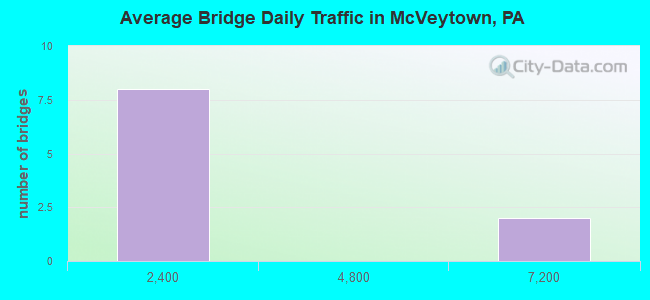
- 16,582Total average daily traffic
- 1,550Total average daily truck traffic
- 19,299Total future (year 2039) average daily traffic
- National Bridge Inventory (NBI) Registered Bridges for McVeytown
- No street view available for this location
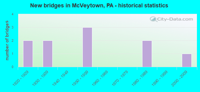
- New bridges - historical statistics
- 21920-1929
- 21930-1939
- 31950-1959
- 21980-1989
- 12000-2009
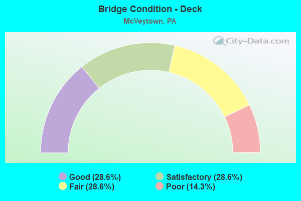
- Bridge Condition - Deck
- 28.6%Good
- 28.6%Satisfactory
- 28.6%Fair
- 14.3%Poor
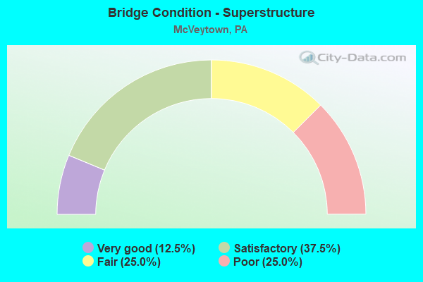
- Bridge Condition - Superstructure
- 12.5%Very good
- 37.5%Satisfactory
- 25.0%Fair
- 25.0%Poor
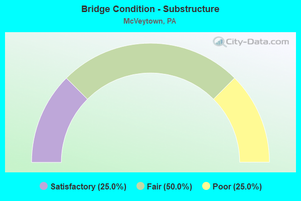
- Bridge Condition - Substructure
- 25.0%Satisfactory
- 50.0%Fair
- 25.0%Poor
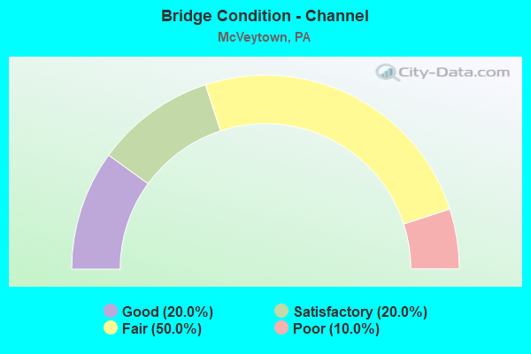
- Bridge Condition - Channel
- 20.0%Good
- 20.0%Satisfactory
- 50.0%Fair
- 10.0%Poor
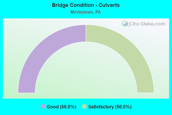
- Bridge Condition - Culverts
- 50.0%Good
- 50.0%Satisfactory
Find on map >> Show street view
Structure Number: 26368, Location: 1 MI SW MCVEYTOWN (Lat: 40.483967, Lng: -77.762733), Route carried "on" structure: US 22, Year Built: 1935, Status: Open, Structure Length: 0.85m (2.79ft), Average Daily Traffic: 6,210 (year 2020), Truck Traffic: 11%, Average Future Daily Traffic: 6,751 (year 2040), Design Load: H 20, Features Intersected: MUSSER RUN
Minimum Vertical Clearance: 30+ m (98+ ft), Kilometerpoint: 15.736, Lanes on structure: 2, Base Highway Network: Yes, Owner: State Highway Agency, Approaching Roadway Width: 10.1m (33.1ft), Material/Design: Concrete, Design/Construction: Arch - Deck, Number Of Spans In Main Unit: 1, Length of Maximum Span: 8.5m (27.9ft), Curb-To-Curb Width: 10.9m (35.8ft), Out-to-Out Width: 12.1m (39.7ft)
Condition: Superstructure: Satisfactory, Substructure: Fair, Channel: Satisfactory, Operating Rating: 75.3 metric tons, Method Used To Determine Operating Rating: Field evaluation and documented engineering judgment, Inventory Rating: 44.5 metric tons, Method Used To Determine Inventory Rating: Field evaluation and documented engineering judgment, Structural Evaluation: Somewhat better than minimum adequacy, Deck Geometry: Meets minimum limits, Waterway Adequacy: Superior to present desirable criteria, Approach Roadway Alignment: Equal to present desirable criteria, Length Of Structure Improvement: 0.90m (2.95ft), Designated Inspection Frequency: Every 24 months, Inspection Date: April 2020, Bridge Improvement Cost: $27,000, Roadway Improvement Cost: $250,000, Total Project Cost: $362,000
Find on map >> Show street view
Structure Number: 26369, Location: MCVEYTOWN (Lat: 40.493789, Lng: -77.742383), Route carried "on" structure: US 22, Year Built: 1933, Status: Open, Structure Length: 1.10m (3.61ft), Average Daily Traffic: 6,210 (year 2020), Truck Traffic: 11%, Average Future Daily Traffic: 6,751 (year 2040), Design Load: H 15, Features Intersected: MUSSER RUN
Minimum Vertical Clearance: 30+ m (98+ ft), Kilometerpoint: 17.225, Lanes on structure: 2, Base Highway Network: Yes, Owner: State Highway Agency, Approaching Roadway Width: 9.8m (32.2ft), Skew: 1 degrees, Material/Design: Concrete, Design/Construction: Tee Beam, Number Of Spans In Main Unit: 1, Length of Maximum Span: 10.4m (34.1ft), Curb-To-Curb Width: 9.6m (31.5ft), Out-to-Out Width: 10.8m (35.4ft)
Condition: Deck: Satisfactory, Superstructure: Satisfactory, Substructure: Fair, Channel: Fair, Operating Rating: 73.5 metric tons, Method Used To Determine Operating Rating: Field evaluation and documented engineering judgment, Inventory Rating: 43.5 metric tons, Method Used To Determine Inventory Rating: Field evaluation and documented engineering judgment, Structural Evaluation: Somewhat better than minimum adequacy, Deck Geometry: High priority of corrective action, Waterway Adequacy: Equal to present minimum criteria, Approach Roadway Alignment: Equal to present desirable criteria, Length Of Structure Improvement: 1.10m (3.61ft), Designated Inspection Frequency: Every 24 months, Inspection Date: April 2020, Bridge Improvement Cost: $35,000, Roadway Improvement Cost: $250,000, Total Project Cost: $468,000, Deck Structure Type: Concrete Cast-file-Place, Wearing Surface/Protective System: Wearing Surface: Bituminous
Find on map >> Show street view
Structure Number: 26557, Location: 1 MILE NW MCVEYTOWN (Lat: 40.503833, Lng: -77.750244), Route carried "on" structure: State highway , Year Built: 1952, Year Reconstructed: 1989, Status: Open, Structure Length: 0.70m (2.30ft), Average Daily Traffic: 452 (year 2020), Truck Traffic: 6%, Average Future Daily Traffic: 649 (year 2040), Design Load: HS 20, Features Intersected: TOWN RUN, Facility Carried by Structure: SR 3009
Minimum Vertical Clearance: 30+ m (98+ ft), Kilometerpoint: 1.136, Lanes on structure: 2, Owner: State Highway Agency, Approaching Roadway Width: 7.9m (25.9ft), Skew: 3 degrees, Material/Design: Prestressed concrete, Design/Construction: Box Beam or Girders - Single/Spread, Number Of Spans In Main Unit: 1, Length of Maximum Span: 6.7m (22.0ft), Curb or Sidewalk Widths: Left: 0.2m (0.7ft), Right: 0.2m (0.7ft), Curb-To-Curb Width: 7.9m (25.9ft), Out-to-Out Width: 8.7m (28.5ft)
Condition: Deck: Good, Superstructure: Very good, Substructure: Satisfactory, Channel: Satisfactory, Operating Rating: 83.5 metric tons, Method Used To Determine Operating Rating: Load Factor (LF), Inventory Rating: 49.9 metric tons, Method Used To Determine Inventory Rating: Load Factor (LF), Structural Evaluation: Equal to present minimum criteria, Deck Geometry: Somewhat better than minimum adequacy, Waterway Adequacy: Better than present minimum criteria, Approach Roadway Alignment: Somewhat better than minimum adequacy, Length Of Structure Improvement: 0.70m (2.30ft), Designated Inspection Frequency: Every 24 months, Inspection Date: June 2020, Bridge Improvement Cost: $22,000, Roadway Improvement Cost: $209,000, Total Project Cost: $296,000, Deck Structure Type: Concrete Cast-file-Place, Wearing Surface/Protective System: Wearing Surface: Monolithic Concrete
Find on map >> Show street view
Structure Number: 26558, Location: 1 MILE NW MCVEYTOWN (Lat: 40.507681, Lng: -77.749856), Route carried "on" structure: State highway , Year Built: 1989, Status: Open, Structure Length: 0.98m (3.22ft), Average Daily Traffic: 452 (year 2020), Truck Traffic: 6%, Average Future Daily Traffic: 649 (year 2040), Design Load: HS 25 or greater, Features Intersected: TOWN RUN, Facility Carried by Structure: SR 3009
Minimum Vertical Clearance: 30+ m (98+ ft), Kilometerpoint: 1.645, Lanes on structure: 2, Owner: State Highway Agency, Approaching Roadway Width: 7.3m (24.0ft), Skew: 4 degrees, Material/Design: Concrete, Design/Construction: Culvert, Number Of Spans In Main Unit: 2, Length of Maximum Span: 4.9m (16.1ft)
Condition: Channel: Fair, Culverts: Satisfactory, Operating Rating: 80.7 metric tons, Method Used To Determine Operating Rating: Load Factor (LF), Inventory Rating: 48.1 metric tons, Method Used To Determine Inventory Rating: Load Factor (LF), Structural Evaluation: Equal to present minimum criteria, Waterway Adequacy: Better than present minimum criteria, Approach Roadway Alignment: Equal to present desirable criteria, Length Of Structure Improvement: 0.70m (2.30ft), Designated Inspection Frequency: Every 24 months, Inspection Date: June 2020, Bridge Improvement Cost: $24,000, Roadway Improvement Cost: $209,000, Total Project Cost: $326,000
Find on map >> Show street view
Structure Number: 26561, Location: MCVEYTOWN (Lat: 40.497942, Lng: -77.738964), Route carried "on" structure: State highway , Year Built: 1985, Status: Open, Structure Length: 11.52m (37.80ft), Average Daily Traffic: 1,779 (year 2022), Truck Traffic: 4%, Average Future Daily Traffic: 2,733 (year 2040), Design Load: HS 20, Features Intersected: JUNIATA RIVER, Facility Carried by Structure: SR 3014
Minimum Vertical Clearance: 30+ m (98+ ft), Kilometerpoint: 0.000, Lanes on structure: 2, Owner: State Highway Agency, Approaching Roadway Width: 7.9m (25.9ft), Material/Design: Prestressed concrete, Design/Construction: Box Beam or Girders - Single/Spread, Number Of Spans In Main Unit: 4, Length of Maximum Span: 29.0m (95.1ft), Curb or Sidewalk Widths: Left: 0.2m (0.7ft), Right: 0.2m (0.7ft), Curb-To-Curb Width: 9.2m (30.2ft), Out-to-Out Width: 10.3m (33.8ft)
Condition: Deck: Good, Superstructure: Fair, Substructure: Satisfactory, Channel: Good, Inventory Rating: 46.3 metric tons, Method Used To Determine Inventory Rating: Load Factor (LF), Structural Evaluation: Somewhat better than minimum adequacy, Deck Geometry: Somewhat better than minimum adequacy, Waterway Adequacy: Superior to present desirable criteria, Approach Roadway Alignment: Equal to present desirable criteria, Length Of Structure Improvement: 11.50m (37.73ft), Designated Inspection Frequency: Every 24 months, Inspection Date: April 2020, Bridge Improvement Cost: $45,000, Roadway Improvement Cost: $250,000, Total Project Cost: $604,000, Deck Structure Type: Concrete Cast-file-Place, Wearing Surface/Protective System: Wearing Surface: Monolithic Concrete, Deck Protection: Epoxy Coated Reinforcing
Find on map >> Show street view
Structure Number: 26563, Location: MCVEYTOWN (Lat: 40.492867, Lng: -77.741547), Route carried "on" structure: State highway , Year Built: 1957, Status: Open, Structure Length: 1.28m (4.20ft), Average Daily Traffic: 422 (year 2020), Truck Traffic: 8%, Average Future Daily Traffic: 418 (year 2040), Design Load: HS 20, Features Intersected: MUSSER RUN, Facility Carried by Structure: ON TSR 329
Minimum Vertical Clearance: 30+ m (98+ ft), Kilometerpoint: 0.000, Lanes on structure: 2, Owner: State Highway Agency, Approaching Roadway Width: 5.5m (18.0ft), Skew: 1 degrees, Material/Design: Prestressed concrete, Design/Construction: Box Beam or Girders - Multiple, Number Of Spans In Main Unit: 1, Length of Maximum Span: 12.2m (40.0ft), Curb-To-Curb Width: 8.2m (26.9ft), Out-to-Out Width: 9.0m (29.5ft)
Condition: Deck: Satisfactory, Superstructure: Satisfactory, Substructure: Fair, Channel: Fair, Inventory Rating: 85.3 metric tons, Method Used To Determine Inventory Rating: Load Factor (LF), Structural Evaluation: Somewhat better than minimum adequacy, Deck Geometry: Somewhat better than minimum adequacy, Waterway Adequacy: Better than present minimum criteria, Approach Roadway Alignment: Equal to present desirable criteria, Length Of Structure Improvement: 1.30m (4.27ft), Designated Inspection Frequency: Every 24 months, Inspection Date: April 2020, Bridge Improvement Cost: $29,000, Roadway Improvement Cost: $250,000, Total Project Cost: $390,000, Deck Structure Type: Other, Wearing Surface/Protective System: Wearing Surface: Bituminous
Find on map >> Show street view
Structure Number: 26592, Location: 1 MI NW MCVEYTOWN (Lat: 40.515861, Lng: -77.755967), Route carried "on" structure: State highway , Year Built: 1950, Status: Open, Structure Length: 0.79m (2.59ft), Average Daily Traffic: 656 (year 2021), Truck Traffic: 3%, Average Future Daily Traffic: 640 (year 2040), Design Load: HS 20, Features Intersected: SPRING RUN, Facility Carried by Structure: ON TSR 328
Minimum Vertical Clearance: 30+ m (98+ ft), Kilometerpoint: 0.021, Lanes on structure: 2, Owner: State Highway Agency, Approaching Roadway Width: 6.1m (20.0ft), Skew: 3 degrees, Material/Design: Concrete, Design/Construction: Tee Beam, Number Of Spans In Main Unit: 1, Length of Maximum Span: 6.7m (22.0ft), Curb or Sidewalk Widths: Left: 0.2m (0.7ft), Right: 0.2m (0.7ft), Curb-To-Curb Width: 7.3m (24.0ft), Out-to-Out Width: 8.5m (27.9ft)
Condition: Deck: Fair, Superstructure: Fair, Substructure: Fair, Channel: Fair, Operating Rating: 52.6 metric tons, Method Used To Determine Operating Rating: Load Factor (LF), Inventory Rating: 31.8 metric tons, Method Used To Determine Inventory Rating: Load Factor (LF), Structural Evaluation: Somewhat better than minimum adequacy, Deck Geometry: Meets minimum limits, Waterway Adequacy: Better than present minimum criteria, Approach Roadway Alignment: Equal to present desirable criteria, Length Of Structure Improvement: 0.80m (2.62ft), Designated Inspection Frequency: Every 24 months, Inspection Date: June 2020, Bridge Improvement Cost: $22,000, Roadway Improvement Cost: $207,000, Total Project Cost: $295,000, Deck Structure Type: Concrete Cast-file-Place, Wearing Surface/Protective System: Wearing Surface: Bituminous
Find on map >> Show street view
Structure Number: 26643, Location: WEST END OF MCVEYTOWN (Lat: 40.495428, Lng: -77.743525), Route carried "on" structure: City street , Year Built: 1922, Status: Open, Structure Length: 0.98m (3.22ft), Average Daily Traffic: 150 (year 2021), Truck Traffic: 1%, Average Future Daily Traffic: 160 (year 2041), Design Load: H 20, Features Intersected: MUSSER RUN, Facility Carried by Structure: T-803
Minimum Vertical Clearance: 30+ m (98+ ft), Kilometerpoint: 0.000, Lanes on structure: 2, Owner: Town or Township Highway Agency, Approaching Roadway Width: 6.1m (20.0ft), Material/Design: Concrete, Design/Construction: Tee Beam, Number Of Spans In Main Unit: 1, Length of Maximum Span: 9.4m (30.8ft), Curb or Sidewalk Widths: Left: 0.2m (0.7ft), Right: 0.2m (0.7ft), Curb-To-Curb Width: 7.1m (23.3ft), Out-to-Out Width: 7.9m (25.9ft)
Condition: Deck: Fair, Superstructure: Poor, Substructure: Poor, Channel: Poor, Operating Rating: 55.3 metric tons, Method Used To Determine Operating Rating: Field evaluation and documented engineering judgment, Inventory Rating: 32.7 metric tons, Method Used To Determine Inventory Rating: Field evaluation and documented engineering judgment, Structural Evaluation: Meets minimum limits, Deck Geometry: Meets minimum limits, Waterway Adequacy: Better than present minimum criteria, Approach Roadway Alignment: Equal to present desirable criteria, Length Of Structure Improvement: 0.90m (2.95ft), Designated Inspection Frequency: Every 24 months, Inspection Date: May 2021, Bridge Improvement Cost: $4,000, Roadway Improvement Cost: $35,000, Total Project Cost: $51,000, Deck Structure Type: Concrete Cast-file-Place, Wearing Surface/Protective System: Wearing Surface: Bituminous
Find on map >> Show street view
Structure Number: 26644, Location: EAST END OF MCVEYTOWN (Lat: 40.500350, Lng: -77.739700), Route carried "on" structure: City street , Year Built: 1922, Status: Open, Structure Length: 0.70m (2.30ft), Average Daily Traffic: 50 (year 2021), Average Future Daily Traffic: 250 (year 2041), Design Load: H 20, Features Intersected: TOWN RUN, Facility Carried by Structure: WATER STREET
Minimum Vertical Clearance: 30+ m (98+ ft), Kilometerpoint: 0.000, Lanes on structure: 2, Owner: Town or Township Highway Agency, Approaching Roadway Width: 5.8m (19.0ft), Material/Design: Concrete, Design/Construction: Tee Beam, Number Of Spans In Main Unit: 1, Length of Maximum Span: 6.7m (22.0ft), Curb or Sidewalk Widths: Left: 0.1m (0.3ft), Right: 0.1m (0.3ft), Curb-To-Curb Width: 7.1m (23.3ft), Out-to-Out Width: 7.9m (25.9ft)
Condition: Deck: Poor, Superstructure: Poor, Substructure: Poor, Channel: Good, Operating Rating: 57.2 metric tons, Method Used To Determine Operating Rating: Field evaluation and documented engineering judgment, Inventory Rating: 34.5 metric tons, Method Used To Determine Inventory Rating: Field evaluation and documented engineering judgment, Structural Evaluation: Meets minimum limits, Deck Geometry: Somewhat better than minimum adequacy, Waterway Adequacy: Superior to present desirable criteria, Approach Roadway Alignment: Equal to present desirable criteria, Length Of Structure Improvement: 0.60m (1.97ft), Designated Inspection Frequency: Every 24 months, Inspection Date: May 2021, Roadway Improvement Cost: $4,000, Total Project Cost: $12,000, Deck Structure Type: Concrete Cast-file-Place, Wearing Surface/Protective System: Wearing Surface: Bituminous
Find on map >> Show street view
Structure Number: 45104, Location: .4 MILES WEST OF SR 3009 (Lat: 40.517764, Lng: -77.760675), Route carried "on" structure: City street , Year Built: 2008, Status: Open, Structure Length: 0.64m (2.10ft), Average Daily Traffic: 201 (year 2019), Truck Traffic: 3%, Average Future Daily Traffic: 298 (year 2039), Design Load: HL 93, Features Intersected: TOWN RUN, Facility Carried by Structure: T-702
Minimum Vertical Clearance: 30+ m (98+ ft), Kilometerpoint: 0.000, Lanes on structure: 2, Owner: Town or Township Highway Agency, Approaching Roadway Width: 5.2m (17.1ft), Material/Design: Concrete, Design/Construction: Culvert, Number Of Spans In Main Unit: 1, Length of Maximum Span: 6.4m (21.0ft), Curb-To-Curb Width: 7.7m (25.3ft), Out-to-Out Width: 8.8m (28.9ft)
Condition: Channel: Fair, Culverts: Good, Operating Rating: 73.5 metric tons, Method Used To Determine Operating Rating: Load and Resistance Factor (LRFR), Inventory Rating: 57.2 metric tons, Method Used To Determine Inventory Rating: Load and Resistance Factor (LRFR), Structural Evaluation: Better than present minimum criteria, Deck Geometry: Somewhat better than minimum adequacy, Waterway Adequacy: Superior to present desirable criteria, Approach Roadway Alignment: Equal to present desirable criteria, Designated Inspection Frequency: Every 24 months, Inspection Date: May 2021, Wearing Surface/Protective System: Wearing Surface: Bituminous, Membrane: Preformed Fabric