Bridge Statistics for Meadow Woods, Florida (FL)
Condition, Traffic, Stress, Structural Evaluation, Project Costs
- National Bridge Inventory (NBI) Statistics
- 26Number of bridges
- 381ft / 116mTotal length
- 755,700Total average daily traffic
- 55,228Total average daily truck traffic
- National Bridge Inventory (NBI) Registered Bridges for Meadow Woods
- No street view available for this location
- New bridges - historical statistics
- 21960-1969
- 11980-1989
- 181990-1999
- 32000-2009
- 12010-2019
- 12020-2022
- Reconstructed bridges - Historical Statistics
- 11980-1989
- 01990-1999
- 22000-2009

- Bridge Condition - Deck
- 10.5%Very good
- 73.7%Good
- 15.8%Satisfactory
- Bridge Condition - Superstructure
- 21.1%Very good
- 78.9%Good
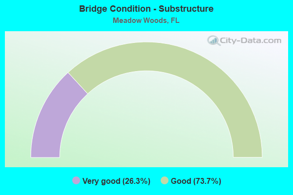
- Bridge Condition - Substructure
- 26.3%Very good
- 73.7%Good
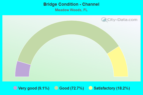
- Bridge Condition - Channel
- 9.1%Very good
- 72.7%Good
- 18.2%Satisfactory
Find on map >> Show street view
Structure Number: 700029, Location: SR-405 WB Over US-1 (Lat: 28.527872, Lng: -80.789506), Route carried "on" structure: State highway 405, Year Built: 1964, Status: Open, Structure Length: 6.75m (22.15ft), Average Daily Traffic: 7,550 (year 2020), Truck Traffic: 4%, Average Future Daily Traffic: 13,099 (year 2042), Design Load: HS 20, Features Intersected: US-1
Minimum Vertical Clearance: 30+ m (98+ ft), Kilometerpoint: 6.774, Lanes on structure: 3, Lanes under structure: 6, Owner: State Highway Agency, Approaching Roadway Width: 10.7m (35.1ft), Skew: 1 degrees, Material/Design: Prestressed concrete, Design/Construction: Stringer/Multi-beam, Number Of Spans In Main Unit: 4, Length of Maximum Span: 20.4m (66.9ft), Curb-To-Curb Width: 12.1m (39.7ft), Out-to-Out Width: 14.1m (46.3ft)
Condition: Deck: Good, Superstructure: Good, Substructure: Good, Operating Rating: 59.3 metric tons, Method Used To Determine Operating Rating: Load Factor (LF), Inventory Rating: 37.3 metric tons, Method Used To Determine Inventory Rating: Load Factor (LF), Structural Evaluation: Better than present minimum criteria, Deck Geometry: Meets minimum limits, Underclear: Equal to present minimum criteria, Approach Roadway Alignment: Equal to present desirable criteria, Designated Inspection Frequency: Every 24 months, Inspection Date: December 2021, Deck Structure Type: Concrete Cast-file-Place, Wearing Surface/Protective System: Wearing Surface: Bituminous
Find on map >> Show street view
Structure Number: 700046, Location: 1.2 Mi N L.Washington Rd. (Lat: 28.163050, Lng: -80.705875), Route carried "on" structure: Interstate 95, Year Built: 1964, Year Reconstructed: 1994, Status: Open, Structure Length: 0.77m (2.53ft), Average Daily Traffic: 91,000 (year 2020), Truck Traffic: 10%, Average Future Daily Traffic: 157,885 (year 2042), Design Load: HS 20, Features Intersected: Milner's Canal
Minimum Vertical Clearance: 30+ m (98+ ft), Kilometerpoint: 42.617, Lanes on structure: 6, Base Highway Network: Yes, Owner: State Highway Agency, Approaching Roadway Width: 35.7m (117.1ft), Skew: 20 degrees, Material/Design: Concrete, Design/Construction: Culvert, Number Of Spans In Main Unit: 3, Length of Maximum Span: 2.4m (7.9ft)
Condition: Channel: Satisfactory, Culverts: Satisfactory, Operating Rating: 62.6 metric tons, Method Used To Determine Operating Rating: Load Factor (LF), Inventory Rating: 37.6 metric tons, Method Used To Determine Inventory Rating: Load Factor (LF), Structural Evaluation: Equal to present minimum criteria, Waterway Adequacy: Equal to present desirable criteria, Approach Roadway Alignment: Equal to present desirable criteria, Designated Inspection Frequency: Every 24 months, Inspection Date: January 2022
Find on map >> Show street view
Structure Number: 750443, Location: SR-417NB-CSX Railroad (Lat: 28.368153, Lng: -81.373183), Route carried "on" structure: State highway 417, Year Built: 1993, Status: Open, Structure Length: 3.58m (11.75ft), Average Daily Traffic: 67,500 (year 2020), Truck Traffic: 7%, Average Future Daily Traffic: 117,113 (year 2042), Design Load: HS 20+Mod, Features Intersected: CSX Railroad
Minimum Vertical Clearance: 30+ m (98+ ft), Kilometerpoint: 11.096, Lanes on structure: 3, Base Highway Network: Yes, Toll: On toll road, Owner: State Toll Authority, Approaching Roadway Width: 8.6m (28.2ft), Skew: 1 degrees, Material/Design: Prestressed concrete, Design/Construction: Stringer/Multi-beam, Number Of Spans In Main Unit: 1, Length of Maximum Span: 35.2m (115.5ft), Curb-To-Curb Width: 8.6m (28.2ft), Out-to-Out Width: 18.0m (59.1ft)
Condition: Deck: Satisfactory, Superstructure: Good, Substructure: Good, Inventory Rating: 54.9 metric tons, Method Used To Determine Inventory Rating: Load Factor (LF), Structural Evaluation: Better than present minimum criteria, Deck Geometry: High priority of replacement, Underclear: Superior to present desirable criteria, Approach Roadway Alignment: Equal to present desirable criteria, Designated Inspection Frequency: Every 24 months, Inspection Date: November 2021, Deck Structure Type: Concrete Cast-file-Place, Wearing Surface/Protective System: Wearing Surface: Monolithic Concrete
Find on map >> Show street view
Structure Number: 750444, Location: SR-417 NB-CSX Railroad (Lat: 28.367950, Lng: -81.373228), Route carried "on" structure: State highway 417, Year Built: 1993, Status: Open, Structure Length: 3.49m (11.45ft), Average Daily Traffic: 7,100 (year 2020), Truck Traffic: 6%, Average Future Daily Traffic: 12,318 (year 2042), Design Load: HS 20+Mod, Features Intersected: CSX Railroad
Minimum Vertical Clearance: 30+ m (98+ ft), Kilometerpoint: 0.029, Lanes on structure: 2, Base Highway Network: Yes, Toll: On toll road, Owner: State Toll Authority, Approaching Roadway Width: 11.4m (37.4ft), Skew: 1 degrees, Material/Design: Prestressed concrete, Design/Construction: Stringer/Multi-beam, Number Of Spans In Main Unit: 1, Length of Maximum Span: 34.3m (112.5ft), Curb-To-Curb Width: 12.2m (40.0ft), Out-to-Out Width: 13.1m (43.0ft)
Condition: Deck: Satisfactory, Superstructure: Good, Substructure: Good, Operating Rating: 82.6 metric tons, Method Used To Determine Operating Rating: Load Factor (LF), Inventory Rating: 49.5 metric tons, Method Used To Determine Inventory Rating: Load Factor (LF), Structural Evaluation: Better than present minimum criteria, Deck Geometry: Better than present minimum criteria, Underclear: Superior to present desirable criteria, Approach Roadway Alignment: Equal to present desirable criteria, Designated Inspection Frequency: Every 24 months, Inspection Date: November 2021, Deck Structure Type: Concrete Cast-file-Place
Find on map >> Show street view
Structure Number: 750445, Location: SR-417 Landstar Blvd (Lat: 28.368856, Lng: -81.366997), Route carried "on" structure: State highway 417, Year Built: 1993, Status: Open, Structure Length: 4.36m (14.30ft), Average Daily Traffic: 33,750 (year 2020), Truck Traffic: 7%, Average Future Daily Traffic: 58,556 (year 2042), Design Load: HS 20+Mod, Features Intersected: Landstar Blvd.
Minimum Vertical Clearance: 30+ m (98+ ft), Kilometerpoint: 11.700, Lanes on structure: 2, Lanes under structure: 5, Base Highway Network: Yes, Toll: On toll road, Owner: State Toll Authority, Approaching Roadway Width: 11.7m (38.4ft), Material/Design: Prestressed concrete, Design/Construction: Stringer/Multi-beam, Number Of Spans In Main Unit: 1, Length of Maximum Span: 43.0m (141.1ft), Curb-To-Curb Width: 12.2m (40.0ft), Out-to-Out Width: 13.1m (43.0ft)
Condition: Deck: Good, Superstructure: Good, Substructure: Good, Inventory Rating: 59.6 metric tons, Method Used To Determine Inventory Rating: Load Factor (LF), Structural Evaluation: Better than present minimum criteria, Deck Geometry: Better than present minimum criteria, Underclear: Better than present minimum criteria, Approach Roadway Alignment: Equal to present desirable criteria, Designated Inspection Frequency: Every 24 months, Inspection Date: September 2021, Deck Structure Type: Concrete Cast-file-Place
Find on map >> Show street view
Structure Number: 750446, Location: SR-417 Landstar Blvd (Lat: 28.368608, Lng: -81.366917), Route carried "on" structure: State highway 417, Year Built: 1993, Status: Open, Structure Length: 4.36m (14.30ft), Average Daily Traffic: 33,750 (year 2020), Truck Traffic: 7%, Average Future Daily Traffic: 58,556 (year 2042), Design Load: HS 20+Mod, Features Intersected: Landstar Blvd.
Minimum Vertical Clearance: 30+ m (98+ ft), Kilometerpoint: 11.703, Lanes on structure: 2, Lanes under structure: 5, Base Highway Network: Yes, Toll: On toll road, Owner: State Toll Authority, Approaching Roadway Width: 11.6m (38.1ft), Material/Design: Prestressed concrete, Design/Construction: Stringer/Multi-beam, Number Of Spans In Main Unit: 1, Length of Maximum Span: 43.0m (141.1ft), Curb-To-Curb Width: 12.2m (40.0ft), Out-to-Out Width: 13.1m (43.0ft)
Condition: Deck: Good, Superstructure: Good, Substructure: Good, Inventory Rating: 59.6 metric tons, Method Used To Determine Inventory Rating: Load Factor (LF), Structural Evaluation: Better than present minimum criteria, Deck Geometry: Better than present minimum criteria, Underclear: Better than present minimum criteria, Approach Roadway Alignment: Equal to present desirable criteria, Designated Inspection Frequency: Every 24 months, Inspection Date: September 2021, Deck Structure Type: Concrete Cast-file-Place
Find on map >> Show street view
Structure Number: 750447, Location: SR-417SB - Rhode Isl. Wds (Lat: 28.368894, Lng: -81.347661), Route carried "on" structure: State highway 417, Year Built: 1993, Status: Open, Structure Length: 2.44m (8.01ft), Average Daily Traffic: 67,500 (year 2020), Truck Traffic: 7%, Average Future Daily Traffic: 117,113 (year 2042), Design Load: HS 20+Mod, Features Intersected: Rhode Island Woods
Minimum Vertical Clearance: 30+ m (98+ ft), Kilometerpoint: 13.610, Lanes on structure: 2, Lanes under structure: 2, Base Highway Network: Yes, Toll: On toll road, Owner: State Toll Authority, Approaching Roadway Width: 10.7m (35.1ft), Skew: 1 degrees, Material/Design: Prestressed concrete, Design/Construction: Stringer/Multi-beam, Number Of Spans In Main Unit: 1, Length of Maximum Span: 23.8m (78.1ft), Curb-To-Curb Width: 12.2m (40.0ft), Out-to-Out Width: 13.1m (43.0ft)
Condition: Deck: Good, Superstructure: Good, Substructure: Good, Operating Rating: 84.6 metric tons, Method Used To Determine Operating Rating: Load Factor (LF), Inventory Rating: 52.5 metric tons, Method Used To Determine Inventory Rating: Load Factor (LF), Structural Evaluation: Better than present minimum criteria, Deck Geometry: Better than present minimum criteria, Underclear: Superior to present desirable criteria, Approach Roadway Alignment: Equal to present desirable criteria, Designated Inspection Frequency: Every 24 months, Inspection Date: November 2021, Deck Structure Type: Concrete Cast-file-Place, Wearing Surface/Protective System: Wearing Surface: Monolithic Concrete
Find on map >> Show street view
Structure Number: 750448, Location: SR-417NB - Rhode Isl. Wds (Lat: 28.368636, Lng: -81.347739), Route carried "on" structure: State highway 417, Year Built: 1993, Status: Open, Structure Length: 2.44m (8.01ft), Average Daily Traffic: 67,500 (year 2020), Truck Traffic: 7%, Average Future Daily Traffic: 117,113 (year 2042), Design Load: HS 20+Mod, Features Intersected: Rhode Island Woods
Minimum Vertical Clearance: 30+ m (98+ ft), Kilometerpoint: 13.604, Lanes on structure: 2, Lanes under structure: 2, Base Highway Network: Yes, Toll: On toll road, Owner: State Toll Authority, Approaching Roadway Width: 9.2m (30.2ft), Skew: 1 degrees, Material/Design: Prestressed concrete, Design/Construction: Stringer/Multi-beam, Number Of Spans In Main Unit: 1, Length of Maximum Span: 23.8m (78.1ft), Curb-To-Curb Width: 9.2m (30.2ft), Out-to-Out Width: 13.1m (43.0ft)
Condition: Deck: Good, Superstructure: Good, Substructure: Very good, Operating Rating: 84.6 metric tons, Method Used To Determine Operating Rating: Load Factor (LF), Inventory Rating: 52.5 metric tons, Method Used To Determine Inventory Rating: Load Factor (LF), Structural Evaluation: Better than present minimum criteria, Deck Geometry: High priority of replacement, Underclear: Superior to present desirable criteria, Approach Roadway Alignment: Equal to present desirable criteria, Designated Inspection Frequency: Every 24 months, Inspection Date: November 2021, Deck Structure Type: Concrete Cast-file-Place, Wearing Surface/Protective System: Wearing Surface: Monolithic Concrete
Find on map >> Show street view
Structure Number: 750449, Location: SR-417SB On Ramp-Boggy Ck (Lat: 28.369478, Lng: -81.310969), Route carried "on" structure: Ramp State highway 417, Year Built: 1992, Status: Open, Structure Length: 7.38m (24.21ft), Average Daily Traffic: 7,000 (year 2020), Truck Traffic: 6%, Average Future Daily Traffic: 12,145 (year 2042), Design Load: HS 20+Mod, Features Intersected: Boggy Creek
Minimum Vertical Clearance: 30.45m (99.90ft), Kilometerpoint: 0.093, Lanes on structure: 1, Toll: On toll road, Owner: State Toll Authority, Approaching Roadway Width: 6.1m (20.0ft), Skew: 2 degrees, Material/Design: Prestressed concrete, Design/Construction: Stringer/Multi-beam, Number Of Spans In Main Unit: 4, Length of Maximum Span: 18.3m (60.0ft), Curb-To-Curb Width: 8.2m (26.9ft), Out-to-Out Width: 9.2m (30.2ft)
Condition: Deck: Good, Superstructure: Very good, Substructure: Good, Channel: Good, Operating Rating: 83.6 metric tons, Method Used To Determine Operating Rating: Load Factor (LF), Inventory Rating: 51.6 metric tons, Method Used To Determine Inventory Rating: Load Factor (LF), Structural Evaluation: Better than present minimum criteria, Deck Geometry: Superior to present desirable criteria, Waterway Adequacy: Superior to present desirable criteria, Approach Roadway Alignment: Equal to present desirable criteria, Designated Inspection Frequency: Every 24 months, Underwater Inspection Frequency: Every 24 months, Inspection Date: November 2021, Underwater Inspection Date: November 2021, Deck Structure Type: Concrete Cast-file-Place, Wearing Surface/Protective System: Wearing Surface: Monolithic Concrete
Find on map >> Show street view
Structure Number: 75045, Location: SR-417 SB - Boggy Creek (Lat: 28.369078, Lng: -81.311031), Route carried "on" structure: State highway 417, Year Built: 1992, Status: Open, Structure Length: 10.42m (34.19ft), Average Daily Traffic: 33,750 (year 2020), Truck Traffic: 7%, Average Future Daily Traffic: 58,556 (year 2042), Design Load: HS 20+Mod, Features Intersected: Boggy Creek
Minimum Vertical Clearance: 30.45m (99.90ft), Kilometerpoint: 17.205, Lanes on structure: 2, Base Highway Network: Yes, Toll: On toll road, Owner: State Toll Authority, Approaching Roadway Width: 11.9m (39.0ft), Skew: 3 degrees, Material/Design: Prestressed concrete, Design/Construction: Stringer/Multi-beam, Number Of Spans In Main Unit: 4, Length of Maximum Span: 25.9m (85.0ft), Curb-To-Curb Width: 12.2m (40.0ft), Out-to-Out Width: 13.1m (43.0ft)
Condition: Deck: Good, Superstructure: Good, Substructure: Good, Channel: Good, Inventory Rating: 58.3 metric tons, Method Used To Determine Inventory Rating: Load Factor (LF), Structural Evaluation: Better than present minimum criteria, Deck Geometry: Better than present minimum criteria, Waterway Adequacy: Superior to present desirable criteria, Approach Roadway Alignment: Equal to present desirable criteria, Designated Inspection Frequency: Every 24 months, Inspection Date: November 2021, Deck Structure Type: Concrete Cast-file-Place, Wearing Surface/Protective System: Wearing Surface: Monolithic Concrete
Find on map >> Show street view
Structure Number: 750451, Location: SR-417 NB - Boggy Creek (Lat: 28.368819, Lng: -81.311061), Route carried "on" structure: State highway 417, Year Built: 1992, Status: Open, Structure Length: 10.42m (34.19ft), Average Daily Traffic: 33,750 (year 2020), Truck Traffic: 7%, Average Future Daily Traffic: 58,556 (year 2042), Design Load: HS 20+Mod, Features Intersected: Boggy Creek
Minimum Vertical Clearance: 30.45m (99.90ft), Kilometerpoint: 17.189, Lanes on structure: 2, Base Highway Network: Yes, Toll: On toll road, Owner: State Toll Authority, Approaching Roadway Width: 10.2m (33.5ft), Skew: 3 degrees, Material/Design: Prestressed concrete, Design/Construction: Stringer/Multi-beam, Number Of Spans In Main Unit: 4, Length of Maximum Span: 25.9m (85.0ft), Curb-To-Curb Width: 12.2m (40.0ft), Out-to-Out Width: 13.1m (43.0ft)
Condition: Deck: Good, Superstructure: Good, Substructure: Good, Channel: Good, Inventory Rating: 58.3 metric tons, Method Used To Determine Inventory Rating: Load Factor (LF), Structural Evaluation: Better than present minimum criteria, Deck Geometry: Better than present minimum criteria, Waterway Adequacy: Superior to present desirable criteria, Approach Roadway Alignment: Equal to present desirable criteria, Designated Inspection Frequency: Every 24 months, Inspection Date: November 2021, Deck Structure Type: Concrete Cast-file-Place, Wearing Surface/Protective System: Wearing Surface: Monolithic Concrete
Find on map >> Show street view
Structure Number: 750452, Location: SR417NB Off Ramp-Boggy Ck (Lat: 28.368325, Lng: -81.311417), Route carried "on" structure: Ramp State highway 417, Year Built: 1992, Status: Open, Structure Length: 7.74m (25.39ft), Average Daily Traffic: 2,800 (year 2020), Truck Traffic: 6%, Average Future Daily Traffic: 4,858 (year 2042), Design Load: HS 20, Features Intersected: Boggy Creek
Minimum Vertical Clearance: 30.45m (99.90ft), Kilometerpoint: 0.224, Lanes on structure: 2, Base Highway Network: Yes, Toll: On toll road, Owner: State Toll Authority, Approaching Roadway Width: 7.2m (23.6ft), Skew: 2 degrees, Material/Design: Prestressed concrete, Design/Construction: Stringer/Multi-beam, Number Of Spans In Main Unit: 4, Length of Maximum Span: 19.2m (63.0ft), Curb-To-Curb Width: 12.2m (40.0ft), Out-to-Out Width: 13.1m (43.0ft)
Condition: Deck: Good, Superstructure: Very good, Substructure: Good, Channel: Good, Operating Rating: 79.4 metric tons, Method Used To Determine Operating Rating: Load Factor (LF), Inventory Rating: 47.7 metric tons, Method Used To Determine Inventory Rating: Load Factor (LF), Structural Evaluation: Better than present minimum criteria, Deck Geometry: Superior to present desirable criteria, Waterway Adequacy: Superior to present desirable criteria, Approach Roadway Alignment: Equal to present desirable criteria, Designated Inspection Frequency: Every 24 months, Underwater Inspection Frequency: Every 24 months, Inspection Date: November 2021, Underwater Inspection Date: November 2021, Deck Structure Type: Concrete Cast-file-Place, Wearing Surface/Protective System: Wearing Surface: Monolithic Concrete
Find on map >> Show street view
Structure Number: 750472, Location: SR-417SB-Wyndham Lakes Bl (Lat: 28.367311, Lng: -81.325442), Route carried "on" structure: State highway 417, Year Built: 1992, Year Reconstructed: 2013, Status: Open, Structure Length: 2.93m (9.61ft), Average Daily Traffic: 67,500 (year 2020), Truck Traffic: 7%, Average Future Daily Traffic: 117,113 (year 2042), Design Load: HL 93, Features Intersected: Wyndham Lakes Blvd
Minimum Vertical Clearance: 30+ m (98+ ft), Kilometerpoint: 15.791, Lanes on structure: 4, Lanes under structure: 4, Base Highway Network: Yes, Toll: On toll road, Owner: State Toll Authority, Approaching Roadway Width: 17.4m (57.1ft), Material/Design: Prestressed concrete, Design/Construction: Stringer/Multi-beam, Number Of Spans In Main Unit: 1, Length of Maximum Span: 28.7m (94.2ft), Curb-To-Curb Width: 18.3m (60.0ft), Out-to-Out Width: 19.2m (63.0ft)
Condition: Deck: Satisfactory, Superstructure: Good, Substructure: Very good, Operating Rating: 49.6 metric tons, Method Used To Determine Operating Rating: Load and Resistance Factor (LRFR), Inventory Rating: 37.9 metric tons, Method Used To Determine Inventory Rating: Load and Resistance Factor (LRFR), Structural Evaluation: Better than present minimum criteria, Deck Geometry: Meets minimum limits, Approach Roadway Alignment: Equal to present desirable criteria, Designated Inspection Frequency: Every 24 months, Inspection Date: November 2021, Deck Structure Type: Concrete Cast-file-Place, Wearing Surface/Protective System: Wearing Surface: Monolithic Concrete
Find on map >> Show street view
Structure Number: 750473, Location: SR-417NB-Wyndham Lakes Bl (Lat: 28.367064, Lng: -81.325431), Route carried "on" structure: State highway 417, Year Built: 1992, Year Reconstructed: 2013, Status: Open, Structure Length: 2.93m (9.61ft), Average Daily Traffic: 67,500 (year 2020), Truck Traffic: 7%, Average Future Daily Traffic: 117,113 (year 2042), Design Load: HL 93, Features Intersected: Wyndham Lakes Blvd
Minimum Vertical Clearance: 30+ m (98+ ft), Kilometerpoint: 15.791, Lanes on structure: 3, Lanes under structure: 4, Base Highway Network: Yes, Toll: On toll road, Owner: State Toll Authority, Approaching Roadway Width: 11.6m (38.1ft), Material/Design: Prestressed concrete, Design/Construction: Stringer/Multi-beam, Number Of Spans In Main Unit: 1, Length of Maximum Span: 28.7m (94.2ft), Curb-To-Curb Width: 11.6m (38.1ft), Out-to-Out Width: 19.2m (63.0ft)
Condition: Deck: Good, Superstructure: Good, Substructure: Very good, Operating Rating: 49.6 metric tons, Method Used To Determine Operating Rating: Load and Resistance Factor (LRFR), Inventory Rating: 37.9 metric tons, Method Used To Determine Inventory Rating: Load and Resistance Factor (LRFR), Structural Evaluation: Better than present minimum criteria, Deck Geometry: High priority of replacement, Approach Roadway Alignment: Equal to present desirable criteria, Designated Inspection Frequency: Every 24 months, Inspection Date: November 2021, Deck Structure Type: Concrete Cast-file-Place, Wearing Surface/Protective System: Wearing Surface: Monolithic Concrete
Find on map >> Show street view
Structure Number: 754072, Location: 0.1 Mi S Of Wetherbee Rd (Lat: 28.391383, Lng: -81.367850), Route carried "on" structure: City street , Year Built: 1984, Status: Posted for load, Structure Length: 3.66m (12.01ft), Average Daily Traffic: 13,700 (year 2021), Truck Traffic: 5%, Average Future Daily Traffic: 23,770 (year 2042), Design Load: HS 20, Features Intersected: Boggy Creek, Facility Carried by Structure: Landstar Blvd.
Minimum Vertical Clearance: 30+ m (98+ ft), Kilometerpoint: 0.599, Lanes on structure: 2, Owner: County Highway Agency, Approaching Roadway Width: 8.2m (26.9ft), Material/Design: Prestressed concrete, Design/Construction: Slab, Number Of Spans In Main Unit: 4, Length of Maximum Span: 9.1m (29.9ft), Curb or Sidewalk Widths: Left: 1.5m (4.9ft), Right: 0.0m, Curb-To-Curb Width: 10.8m (35.4ft), Out-to-Out Width: 13.6m (44.6ft)
Condition: Deck: Good, Superstructure: Good, Substructure: Good, Channel: Good, Operating Rating: 57.3 metric tons, Method Used To Determine Operating Rating: Allowable Stress (AS), Inventory Rating: 47.8 metric tons, Method Used To Determine Inventory Rating: Allowable Stress (AS), Structural Evaluation: Better than present minimum criteria, Deck Geometry: Meets minimum limits, Waterway Adequacy: Equal to present desirable criteria, Approach Roadway Alignment: Equal to present desirable criteria, Designated Inspection Frequency: Every 24 months, Underwater Inspection Frequency: Every 24 months, Inspection Date: October 2021, Underwater Inspection Date: October 2021, Deck Structure Type: Concrete Precast Panels, Wearing Surface/Protective System: Wearing Surface: Bituminous
Find on map >> Show street view
Structure Number: 754119, Location: 3.0 Miles North of SR-417 (Lat: 28.391758, Lng: -81.321825), Route carried "on" structure: County highway 5123, Year Built: 2020, Status: Open, Structure Length: 5.49m (18.01ft), Average Daily Traffic: 18,700 (year 2020), Truck Traffic: 13%, Average Future Daily Traffic: 32,445 (year 2042), Design Load: HL 93, Features Intersected: Boggy Creek, Facility Carried by Structure: Boggy Creek Rd NB
Minimum Vertical Clearance: 30+ m (98+ ft), Kilometerpoint: 5.493, Lanes on structure: 2, Owner: County Highway Agency, Approaching Roadway Width: 10.4m (34.1ft), Material/Design: Prestressed concrete, Design/Construction: Stringer/Multi-beam, Number Of Spans In Main Unit: 3, Length of Maximum Span: 18.3m (60.0ft), Curb or Sidewalk Widths: Left: 0.0m, Right: 1.9m (6.2ft), Curb-To-Curb Width: 9.9m (32.5ft), Out-to-Out Width: 12.8m (42.0ft)
Condition: Deck: Very good, Superstructure: Very good, Substructure: Very good, Channel: Very good, Operating Rating: 66.3 metric tons, Method Used To Determine Operating Rating: Load and Resistance Factor (LRFR), Inventory Rating: 51.0 metric tons, Method Used To Determine Inventory Rating: Load and Resistance Factor (LRFR), Structural Evaluation: Equal to present desirable criteria, Deck Geometry: Meets minimum limits, Waterway Adequacy: Equal to present desirable criteria, Approach Roadway Alignment: Equal to present desirable criteria, Designated Inspection Frequency: Every 24 months, Underwater Inspection Frequency: Every 24 months, Inspection Date: Febuary 2022, Underwater Inspection Date: Febuary 2022, Deck Structure Type: Concrete Cast-file-Place, Wearing Surface/Protective System: Wearing Surface: Monolithic Concrete
Find on map >> Show street view
Structure Number: 75412, Location: 3.0 Miles North of SR 417 (Lat: 28.391575, Lng: -81.321933), Route carried "on" structure: County highway 5123, Year Built: 2012, Status: Open, Structure Length: 5.55m (18.21ft), Average Daily Traffic: 18,700 (year 2020), Truck Traffic: 13%, Average Future Daily Traffic: 32,445 (year 2042), Design Load: HL 93, Features Intersected: Boggy Creek, Facility Carried by Structure: Boggy Creek Road
Minimum Vertical Clearance: 30+ m (98+ ft), Kilometerpoint: 5.493, Lanes on structure: 2, Owner: County Highway Agency, Approaching Roadway Width: 10.4m (34.1ft), Material/Design: Prestressed concrete, Design/Construction: Stringer/Multi-beam, Number Of Spans In Main Unit: 3, Length of Maximum Span: 18.3m (60.0ft), Curb or Sidewalk Widths: Left: 1.9m (6.2ft), Right: 0.0m, Curb-To-Curb Width: 9.9m (32.5ft), Out-to-Out Width: 12.8m (42.0ft)
Condition: Deck: Very good, Superstructure: Very good, Substructure: Very good, Channel: Good, Operating Rating: 66.3 metric tons, Method Used To Determine Operating Rating: Load and Resistance Factor (LRFR), Inventory Rating: 51.3 metric tons, Method Used To Determine Inventory Rating: Load and Resistance Factor (LRFR), Structural Evaluation: Equal to present desirable criteria, Deck Geometry: Meets minimum limits, Waterway Adequacy: Equal to present desirable criteria, Approach Roadway Alignment: Equal to present desirable criteria, Designated Inspection Frequency: Every 24 months, Underwater Inspection Frequency: Every 24 months, Inspection Date: Febuary 2022, Underwater Inspection Date: Febuary 2022, Deck Structure Type: Concrete Cast-file-Place
Find on map >> Show street view
Structure Number: 754141, Location: 0.2 mi. W of Boggy Ck Rd. (Lat: 28.372381, Lng: -81.311897), Route carried "on" structure: County highway , Year Built: 2004, Status: Open, Structure Length: 19.54m (64.11ft), Average Daily Traffic: 7,800 (year 2021), Truck Traffic: 6%, Average Future Daily Traffic: 13,533 (year 2042), Features Intersected: Boggy Creek, Facility Carried by Structure: J. Lawson Blvd.
Minimum Vertical Clearance: 30+ m (98+ ft), Kilometerpoint: 1.485, Lanes on structure: 4, Owner: County Highway Agency, Approaching Roadway Width: 18.0m (59.1ft), Skew: 23 degrees, Material/Design: Prestressed concrete, Design/Construction: Stringer/Multi-beam, Number Of Spans In Main Unit: 9, Length of Maximum Span: 21.6m (70.9ft), Curb or Sidewalk Widths: Left: 1.6m (5.2ft), Right: 1.6m (5.2ft), Curb-To-Curb Width: 18.0m (59.1ft), Out-to-Out Width: 26.7m (87.6ft)
Condition: Deck: Good, Superstructure: Good, Substructure: Good, Channel: Good, Operating Rating: 50.8 metric tons, Method Used To Determine Operating Rating: Load Factor (LF), Inventory Rating: 32.6 metric tons, Method Used To Determine Inventory Rating: Load Factor (LF), Structural Evaluation: Better than present minimum criteria, Deck Geometry: Somewhat better than minimum adequacy, Waterway Adequacy: Better than present minimum criteria, Approach Roadway Alignment: Better than present minimum criteria, Designated Inspection Frequency: Every 24 months, Inspection Date: May 2021, Deck Structure Type: Concrete Cast-file-Place
Find on map >> Show street view
Structure Number: 754148, Location: 1.2 mi from Weatherbee Rd (Lat: 28.385056, Lng: -81.354639), Route carried "on" structure: City street , Year Built: 2006, Status: Open, Structure Length: 3.03m (9.94ft), Average Daily Traffic: 1,850 (year 2020), Truck Traffic: 5%, Average Future Daily Traffic: 3,210 (year 2042), Design Load: HL 93, Features Intersected: Boggy Creek, Facility Carried by Structure: Sawgrass Pl. Blvd.
Minimum Vertical Clearance: 30+ m (98+ ft), Kilometerpoint: 0.053, Lanes on structure: 2, Owner: County Highway Agency, Approaching Roadway Width: 9.1m (29.9ft), Skew: 2 degrees, Material/Design: Prestressed concrete, Design/Construction: Stringer/Multi-beam, Number Of Spans In Main Unit: 2, Length of Maximum Span: 15.2m (49.9ft), Curb or Sidewalk Widths: Left: 1.8m (5.9ft), Right: 2.4m (7.9ft), Curb-To-Curb Width: 7.9m (25.9ft), Out-to-Out Width: 13.1m (43.0ft)
Condition: Deck: Good, Superstructure: Good, Substructure: Good, Channel: Satisfactory, Operating Rating: 67.4 metric tons, Method Used To Determine Operating Rating: Load and Resistance Factor (LRFR), Inventory Rating: 52.0 metric tons, Method Used To Determine Inventory Rating: Load and Resistance Factor (LRFR), Structural Evaluation: Better than present minimum criteria, Deck Geometry: Meets minimum limits, Waterway Adequacy: Better than present minimum criteria, Approach Roadway Alignment: Equal to present desirable criteria, Designated Inspection Frequency: Every 24 months, Inspection Date: September 2020, Deck Structure Type: Concrete Cast-file-Place
Find on map >> Show street view
Structure Number: 754154, Location: 0.1 Mi. East of CR-527 (Lat: 28.392778, Lng: -81.372219), Route carried "on" structure: Alternate County highway , Year Built: 2008, Status: Open, Structure Length: 8.23m (27.00ft), Average Daily Traffic: 21,200 (year 2021), Truck Traffic: 6%, Average Future Daily Traffic: 36,782 (year 2042), Design Load: HL 93, Features Intersected: Boggy Creek, Facility Carried by Structure: Wetherbee Road
Minimum Vertical Clearance: 30.45m (99.90ft), Kilometerpoint: 3.251, Lanes on structure: 4, Owner: County Highway Agency, Approaching Roadway Width: 18.9m (62.0ft), Skew: 23 degrees, Material/Design: Concrete continuous, Design/Construction: Slab, Number Of Spans In Main Unit: 9, Length of Maximum Span: 9.1m (29.9ft), Curb or Sidewalk Widths: Left: 1.8m (5.9ft), Right: 1.8m (5.9ft), Curb-To-Curb Width: 18.9m (62.0ft), Out-to-Out Width: 26.8m (87.9ft)
Condition: Deck: Good, Superstructure: Good, Substructure: Good, Channel: Good, Operating Rating: 36.6 metric tons, Method Used To Determine Operating Rating: Load and Resistance Factor (LRFR), Inventory Rating: 28.2 metric tons, Method Used To Determine Inventory Rating: Load and Resistance Factor (LRFR), Structural Evaluation: Better than present minimum criteria, Deck Geometry: Equal to present minimum criteria, Waterway Adequacy: Equal to present desirable criteria, Approach Roadway Alignment: Equal to present desirable criteria, Designated Inspection Frequency: Every 24 months, Underwater Inspection Frequency: Every 24 months, Inspection Date: April 2021, Underwater Inspection Date: April 2021, Deck Structure Type: Concrete Cast-file-Place
Find on map >> Show street view
Structure Number: 750445, Location: SR-417 Landstar Blvd (Lat: 28.368856, Lng: -81.366997), Route carried "under" structure: County highway , Year Built: 1993, Structure Length: 0. m, Average Daily Traffic: 20,700 (year 2020), Truck Traffic: 6%, Features Intersected: Landstar Blvd., Facility Carried by Structure: SR-417 SB
Minimum Vertical Clearance: 5.18m (16.99ft), Kilometerpoint: 2.517, Lanes on structure: 2, Lanes under structure: 5, Material/Design: Prestressed concrete, Design/Construction: Stringer/Multi-beam, Length of Maximum Span: 43.0m (141.1ft)
Find on map >> Show street view
Structure Number: 750446, Location: SR-417 Landstar Blvd (Lat: 28.368608, Lng: -81.366917), Route carried "under" structure: County highway , Year Built: 1993, Structure Length: 0. m, Average Daily Traffic: 20,700 (year 2020), Truck Traffic: 6%, Features Intersected: Landstar Blvd., Facility Carried by Structure: SR-417 NB
Minimum Vertical Clearance: 5.15m (16.90ft), Kilometerpoint: 2.491, Lanes on structure: 2, Lanes under structure: 5, Material/Design: Prestressed concrete, Design/Construction: Stringer/Multi-beam, Length of Maximum Span: 43.0m (141.1ft)
Find on map >> Show street view
Structure Number: 750447, Location: SR-417SB - Rhode Isl. Wds (Lat: 28.368894, Lng: -81.347661), Route carried "under" structure: City street , Year Built: 1993, Structure Length: 0. m, Average Daily Traffic: 6,800 (year 2020), Truck Traffic: 7%, Features Intersected: Rhode Island Woods, Facility Carried by Structure: SR-417 SB
Minimum Vertical Clearance: 5.76m (18.90ft), Kilometerpoint: 2.491, Lanes on structure: 2, Lanes under structure: 2, Material/Design: Prestressed concrete, Design/Construction: Stringer/Multi-beam, Length of Maximum Span: 23.8m (78.1ft)
Find on map >> Show street view
Structure Number: 750448, Location: SR-417NB - Rhode Isl. Wds (Lat: 28.368636, Lng: -81.347739), Route carried "under" structure: City street , Year Built: 1993, Structure Length: 0. m, Average Daily Traffic: 6,800 (year 2020), Truck Traffic: 7%, Features Intersected: Rhode Island Woods, Facility Carried by Structure: SR-417 NB
Minimum Vertical Clearance: 5.76m (18.90ft), Kilometerpoint: 2.462, Lanes on structure: 2, Lanes under structure: 2, Material/Design: Prestressed concrete, Design/Construction: Stringer/Multi-beam, Length of Maximum Span: 23.8m (78.1ft)
Find on map >> Show street view
Structure Number: 750472, Location: SR-417SB-Wyndham Lakes Bl (Lat: 28.367311, Lng: -81.325442), Route carried "under" structure: County highway , Year Built: 1992, Structure Length: 0. m, Average Daily Traffic: 15,400 (year 2020), Truck Traffic: 3%, Features Intersected: Wyndham Lakes Blvd, Facility Carried by Structure: SR-417
Minimum Vertical Clearance: 5.30m (17.39ft), Kilometerpoint: 3.903, Lanes on structure: 4, Lanes under structure: 4, Material/Design: Prestressed concrete, Design/Construction: Stringer/Multi-beam, Length of Maximum Span: 28.7m (94.2ft)
Find on map >> Show street view
Structure Number: 750473, Location: SR-417NB-Wyndham Lakes Bl (Lat: 28.367064, Lng: -81.325431), Route carried "under" structure: County highway , Year Built: 1992, Structure Length: 0. m, Average Daily Traffic: 15,400 (year 2020), Truck Traffic: 3%, Features Intersected: Wyndham Lakes Blvd, Facility Carried by Structure: SR-417
Minimum Vertical Clearance: 5.61m (18.41ft), Kilometerpoint: 3.867, Lanes on structure: 3, Lanes under structure: 4, Material/Design: Prestressed concrete, Design/Construction: Stringer/Multi-beam, Length of Maximum Span: 28.7m (94.2ft)