Bridge Statistics for Mechanicstown, New York (NY)
Condition, Traffic, Stress, Structural Evaluation, Project Costs
- National Bridge Inventory (NBI) Statistics
- 25Number of bridges
- 266ft / 80.9mTotal length
- $143,169,000Total costs
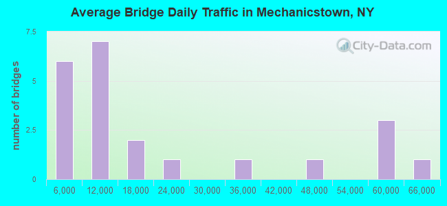
- 434,373Total average daily traffic
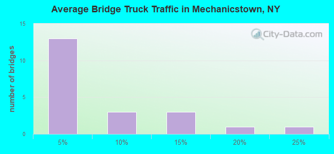
- 33,212Total average daily truck traffic
- National Bridge Inventory (NBI) Registered Bridges for Mechanicstown
- No street view available for this location
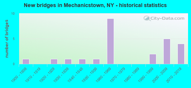
- New bridges - historical statistics
- 11900-1909
- 11920-1929
- 11930-1939
- 11940-1949
- 11950-1959
- 91960-1969
- 21990-1999
- 52000-2009
- 42010-2019
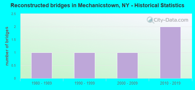
- Reconstructed bridges - Historical Statistics
- 11980-1989
- 11990-1999
- 12000-2009
- 22010-2019
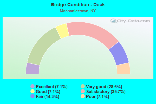
- Bridge Condition - Deck
- 7.1%Excellent
- 28.6%Very good
- 7.1%Good
- 35.7%Satisfactory
- 14.3%Fair
- 7.1%Poor
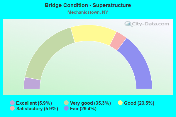
- Bridge Condition - Superstructure
- 5.9%Excellent
- 35.3%Very good
- 23.5%Good
- 5.9%Satisfactory
- 29.4%Fair
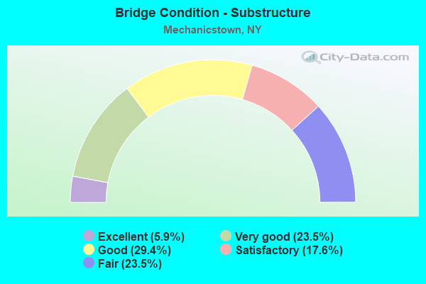
- Bridge Condition - Substructure
- 5.9%Excellent
- 23.5%Very good
- 29.4%Good
- 17.6%Satisfactory
- 23.5%Fair
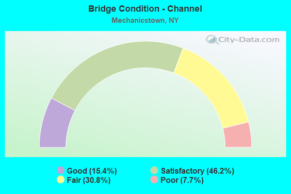
- Bridge Condition - Channel
- 15.4%Good
- 46.2%Satisfactory
- 30.8%Fair
- 7.7%Poor
Find on map >> Show street view
Structure Number: 100313, Location: JCT RTE 6+WALLKILL R (Lat: 41.402125, Lng: -74.389719), Route carried "on" structure: US 6, Year Built: 1931, Year Reconstructed: 1980, Status: Open, Structure Length: 7.50m (24.61ft), Average Daily Traffic: 15,664 (year 2020), Truck Traffic: 8%, Average Future Daily Traffic: 19,028 (year 2040), Design Load: HS 20, Features Intersected: WALLKILL RIVER
Minimum Vertical Clearance: 30+ m (98+ ft), Kilometerpoint: 32.421, Lanes on structure: 2, Base Highway Network: Yes, Owner: State Highway Agency, Approaching Roadway Width: 13.4m (44.0ft), Material/Design: Steel, Design/Construction: Truss - Deck, Number Of Spans In Main Unit: 1, Number Of Approach Spans: 2, Length of Maximum Span: 33.5m (109.9ft), Curb-To-Curb Width: 15.2m (49.9ft), Out-to-Out Width: 15.8m (51.8ft)
Condition: Deck: Satisfactory, Superstructure: Satisfactory, Substructure: Satisfactory, Channel: Fair, Operating Rating: 12.0 metric tons, Method Used To Determine Operating Rating: Load and Resistance Factor Rating (LRFR) rating reported by rating factor(RF) method using HL-93 loadings, Inventory Rating: 9.4 metric tons, Method Used To Determine Inventory Rating: Load and Resistance Factor Rating (LRFR) rating reported by rating factor(RF) method using HL-93 loadings, Structural Evaluation: High priority of corrective action, Deck Geometry: Superior to present desirable criteria, Waterway Adequacy: Meets minimum limits, Approach Roadway Alignment: Meets minimum limits, Length Of Structure Improvement: 7.49m (24.57ft), Designated Inspection Frequency: Every 24 months, Critical Feature Inspection Frequency: Every 24 months, Inspection Date: May 2021, Critical Feature Inspection Date: May 2021, Bridge Improvement Cost: $9,631,000, Roadway Improvement Cost: $5,640,000, Total Project Cost: $15,272,000 ( Estimate for 2021), Deck Structure Type: Concrete Cast-file-Place, Wearing Surface/Protective System: Wearing Surface: Integral Concrete, Deck Protection: Epoxy Coated Reinforcing
Find on map >> Show street view
Structure Number: 101396, Location: .2 MI E JCT SH211 & SH 17 (Lat: 41.457569, Lng: -74.375961), Route carried "on" structure: State highway 17, Year Built: 1949, Year Reconstructed: 2009, Status: Open, Structure Length: 2.13m (6.99ft), Average Daily Traffic: 55,134 (year 2005), Truck Traffic: 11%, Average Future Daily Traffic: 77,777 (year 2040), Design Load: H 20, Features Intersected: MNRR PJ Line/NSRR
Minimum Vertical Clearance: 30+ m (98+ ft), Kilometerpoint: 12.164, Lanes on structure: 5, Base Highway Network: Yes, Owner: State Highway Agency, Approaching Roadway Width: 26.2m (86.0ft), Skew: 23 degrees, Material/Design: Concrete, Design/Construction: Frame, Number Of Spans In Main Unit: 1, Length of Maximum Span: 18.2m (59.7ft), Curb-To-Curb Width: 28.3m (92.8ft), Out-to-Out Width: 31.3m (102.7ft)
Condition: Deck: Fair, Superstructure: Fair, Substructure: Fair, Operating Rating: 55.9 metric tons, Method Used To Determine Operating Rating: Field evaluation and documented engineering judgment, Inventory Rating: 20.3 metric tons, Method Used To Determine Inventory Rating: Field evaluation and documented engineering judgment, Structural Evaluation: Somewhat better than minimum adequacy, Deck Geometry: Superior to present desirable criteria, Underclear: Equal to present minimum criteria, Approach Roadway Alignment: Equal to present desirable criteria, Length Of Structure Improvement: 2.13m (6.99ft), Designated Inspection Frequency: Every 24 months, Inspection Date: August 2021, Bridge Improvement Cost: $8,108,000, Roadway Improvement Cost: $4,748,000, Total Project Cost: $12,856,000 ( Estimate for 2021)
Find on map >> Show street view
Structure Number: 101398, Location: JCT SH17 & WALLKILL RIVER (Lat: 41.439803, Lng: -74.360392), Route carried "on" structure: State highway 17, Year Built: 2005, Status: Open, Structure Length: 11.09m (36.38ft), Average Daily Traffic: 42,145 (year 2015), Truck Traffic: 8%, Average Future Daily Traffic: 59,453 (year 2040), Design Load: HS 25 or greater, Features Intersected: WALLKILL RIVER
Minimum Vertical Clearance: 30+ m (98+ ft), Kilometerpoint: 14.481, Lanes on structure: 4, Base Highway Network: Yes, Owner: State Highway Agency, Approaching Roadway Width: 22.9m (75.1ft), Skew: 20 degrees, Material/Design: Prestressed concrete, Design/Construction: Stringer/Multi-beam, Number Of Spans In Main Unit: 2, Length of Maximum Span: 54.8m (179.8ft), Curb-To-Curb Width: 33.2m (108.9ft), Out-to-Out Width: 35.1m (115.2ft)
Condition: Deck: Satisfactory, Superstructure: Very good, Substructure: Very good, Channel: Satisfactory, Inventory Rating: 40.8 metric tons, Method Used To Determine Inventory Rating: Field evaluation and documented engineering judgment, Structural Evaluation: Equal to present desirable criteria, Deck Geometry: Superior to present desirable criteria, Waterway Adequacy: High priority of corrective action, Approach Roadway Alignment: Equal to present desirable criteria, Length Of Structure Improvement: 11.09m (36.38ft), Designated Inspection Frequency: Every 24 months, Inspection Date: June 2021, Bridge Improvement Cost: $10,084,000, Roadway Improvement Cost: $5,905,000, Total Project Cost: $15,989,000 ( Estimate for 2021), Deck Structure Type: Concrete Cast-file-Place, Wearing Surface/Protective System: Wearing Surface: Integral Concrete, Deck Protection: Epoxy Coated Reinforcing
Find on map >> Show street view
Structure Number: 1040959, Location: 0.5 MI W JCT RTS 211+17 (Lat: 41.455569, Lng: -74.384881), Route carried "on" structure: State highway 211, Year Built: 1969, Status: Open, Structure Length: 1.01m (3.31ft), Average Daily Traffic: 23,019 (year 2018), Truck Traffic: 3%, Average Future Daily Traffic: 27,963 (year 2040), Design Load: H 20, Features Intersected: MASONIC CREEK
Minimum Vertical Clearance: 30+ m (98+ ft), Kilometerpoint: 21.287, Lanes on structure: 8, Base Highway Network: Yes, Owner: State Highway Agency, Approaching Roadway Width: 29.3m (96.1ft), Skew: 31 degrees, Material/Design: Concrete continuous, Design/Construction: Culvert, Number Of Spans In Main Unit: 2, Length of Maximum Span: 4.2m (13.8ft)
Condition: Channel: Satisfactory, Culverts: Satisfactory, Operating Rating: 72.9 metric tons, Method Used To Determine Operating Rating: Field evaluation and documented engineering judgment, Inventory Rating: 32.7 metric tons, Method Used To Determine Inventory Rating: Field evaluation and documented engineering judgment, Structural Evaluation: Equal to present minimum criteria, Waterway Adequacy: Meets minimum limits, Approach Roadway Alignment: Equal to present desirable criteria, Length Of Structure Improvement: 1.00m (3.28ft), Designated Inspection Frequency: Every 24 months, Inspection Date: August 2021, Bridge Improvement Cost: $2,195,000, Roadway Improvement Cost: $1,285,000, Total Project Cost: $3,481,000 ( Estimate for 2021)
Find on map >> Show street view
Structure Number: 1040969, Location: .1 MI W JCT SH 211 & SH17 (Lat: 41.458328, Lng: -74.378811), Route carried "on" structure: State highway 211, Year Built: 1969, Year Reconstructed: 1996, Status: Open, Structure Length: 4.97m (16.31ft), Truck Traffic: 4%, Design Load: HS 20+Mod, Features Intersected: MNRR PJ Line/NSRR
Minimum Vertical Clearance: 30+ m (98+ ft), Kilometerpoint: 21.915, Lanes on structure: 8, Base Highway Network: Yes, Owner: State Highway Agency, Approaching Roadway Width: 30.8m (101.0ft), Skew: 20 degrees, Material/Design: Steel continuous, Design/Construction: Stringer/Multi-beam, Number Of Spans In Main Unit: 3, Length of Maximum Span: 16.7m (54.8ft), Curb-To-Curb Width: 31.8m (104.3ft), Out-to-Out Width: 33.1m (108.6ft)
Condition: Deck: Very good, Superstructure: Very good, Substructure: Good, Inventory Rating: 61.7 metric tons, Method Used To Determine Inventory Rating: Load Factor (LF), Structural Evaluation: Better than present minimum criteria, Deck Geometry: Somewhat better than minimum adequacy, Underclear: Equal to present minimum criteria, Approach Roadway Alignment: Equal to present desirable criteria, Length Of Structure Improvement: 4.96m (16.27ft), Designated Inspection Frequency: Every 24 months, Inspection Date: August 2020, Bridge Improvement Cost: $6,621,000, Roadway Improvement Cost: $3,877,000, Total Project Cost: $10,498,000 ( Estimate for 2021), Deck Structure Type: Concrete Cast-file-Place, Wearing Surface/Protective System: Wearing Surface: Integral Concrete, Deck Protection: Epoxy Coated Reinforcing
Find on map >> Show street view
Structure Number: 1052539, Location: 3.1 MI EAST OF EXIT 3-I84 (Lat: 41.441092, Lng: -74.376719), Route carried "on" structure: Interstate 84, Year Built: 1967, Status: Open, Structure Length: 1.43m (4.69ft), Average Daily Traffic: 32,011 (year 2020), Truck Traffic: 21%, Average Future Daily Traffic: 54,207 (year 2040), Design Load: HS 20, Features Intersected: MASONIC CREEK
Minimum Vertical Clearance: 30+ m (98+ ft), Kilometerpoint: 29.767, Lanes on structure: 4, Base Highway Network: Yes, Owner: State Highway Agency, Approaching Roadway Width: 24.4m (80.1ft), Skew: 20 degrees, Material/Design: Concrete continuous, Design/Construction: Culvert, Number Of Spans In Main Unit: 2, Length of Maximum Span: 6.0m (19.7ft)
Condition: Channel: Fair, Culverts: Satisfactory, Structural Evaluation: Equal to present minimum criteria, Waterway Adequacy: Superior to present desirable criteria, Approach Roadway Alignment: Equal to present desirable criteria, Length Of Structure Improvement: 1.40m (4.59ft), Designated Inspection Frequency: Every 24 months, Inspection Date: November 2021, Bridge Improvement Cost: $963,000, Roadway Improvement Cost: $564,000, Total Project Cost: $1,527,000 ( Estimate for 2021)
Find on map >> Show street view
Structure Number: 105254, Location: 3.8 MI E INT 3 I84 (Lat: 41.441839, Lng: -74.376117), Route carried "on" structure: County highway , Year Built: 1968, Status: Open, Structure Length: 6.64m (21.78ft), Average Daily Traffic: 9,421 (year 2020), Truck Traffic: 4%, Average Future Daily Traffic: 11,444 (year 2040), Design Load: HS 20, Features Intersected: 84I 84I83011186 EB, RTE, Facility Carried by Structure: COUNTY ROAD 67
Minimum Vertical Clearance: 30+ m (98+ ft), Kilometerpoint: 1.754, Lanes on structure: 2, Lanes under structure: 4, Owner: State Highway Agency, Approaching Roadway Width: 12.2m (40.0ft), Material/Design: Steel, Design/Construction: Stringer/Multi-beam, Number Of Spans In Main Unit: 2, Length of Maximum Span: 32.6m (107.0ft), Curb or Sidewalk Widths: Left: 1.5m (4.9ft), Right: 0.5m (1.6ft), Curb-To-Curb Width: 9.1m (29.9ft), Out-to-Out Width: 11.8m (38.7ft)
Condition: Deck: Poor, Superstructure: Fair, Substructure: Satisfactory, Inventory Rating: 66.2 metric tons, Method Used To Determine Inventory Rating: Load Factor (LF), Structural Evaluation: Somewhat better than minimum adequacy, Deck Geometry: Meets minimum limits, Underclear: Meets minimum limits, Approach Roadway Alignment: Equal to present desirable criteria, Length Of Structure Improvement: 6.64m (21.78ft), Designated Inspection Frequency: Every 24 months, Inspection Date: June 2021, Bridge Improvement Cost: $3,530,000, Roadway Improvement Cost: $2,067,000, Total Project Cost: $5,596,000 ( Estimate for 2021), Deck Structure Type: Concrete Cast-file-Place, Wearing Surface/Protective System: Wearing Surface: Integral Concrete
Find on map >> Show street view
Structure Number: 1052559, Location: JCT SH 17 & I84 (Lat: 41.447614, Lng: -74.369767), Route carried "on" structure: State highway 17, Year Built: 1968, Year Reconstructed: 2015, Status: Open, Structure Length: 7.86m (25.79ft), Average Daily Traffic: 55,134 (year 2015), Truck Traffic: 11%, Average Future Daily Traffic: 77,777 (year 2040), Design Load: HS 20, Features Intersected: 84I 84I83011192 SB, RTE
Minimum Vertical Clearance: 30+ m (98+ ft), Kilometerpoint: 13.323, Lanes on structure: 6, Lanes under structure: 6, Base Highway Network: Yes, Owner: State Highway Agency, Approaching Roadway Width: 21.9m (71.9ft), Skew: 21 degrees, Material/Design: Steel, Design/Construction: Stringer/Multi-beam, Number Of Spans In Main Unit: 2, Length of Maximum Span: 37.7m (123.7ft), Curb-To-Curb Width: 35.4m (116.1ft), Out-to-Out Width: 37.2m (122.0ft)
Condition: Deck: Excellent, Superstructure: Good, Substructure: Very good, Inventory Rating: 67.1 metric tons, Method Used To Determine Inventory Rating: Load Factor (LF), Structural Evaluation: Better than present minimum criteria, Deck Geometry: Superior to present desirable criteria, Underclear: Meets minimum limits, Approach Roadway Alignment: Equal to present desirable criteria, Length Of Structure Improvement: 7.86m (25.79ft), Designated Inspection Frequency: Every 24 months, Inspection Date: October 2021, Bridge Improvement Cost: $12,279,000, Roadway Improvement Cost: $7,190,000, Total Project Cost: $19,469,000 ( Estimate for 2021), Deck Structure Type: Concrete Cast-file-Place, Wearing Surface/Protective System: Wearing Surface: Integral Concrete, Deck Protection: Epoxy Coated Reinforcing
Find on map >> Show street view
Structure Number: 107898, Location: .4 mi SE JCT RTS. 211 & 1 (Lat: 41.454144, Lng: -74.373697), Route carried "on" structure: State highway 17, Year Built: 2009, Status: Open, Structure Length: 2.53m (8.30ft), Average Daily Traffic: 55,134 (year 2005), Truck Traffic: 11%, Average Future Daily Traffic: 77,777 (year 2040), Design Load: HL 93, Features Intersected: Wallkill Winning Way
Minimum Vertical Clearance: 30+ m (98+ ft), Kilometerpoint: 12.582, Lanes on structure: 6, Lanes under structure: 3, Base Highway Network: Yes, Owner: State Highway Agency, Approaching Roadway Width: 29.0m (95.1ft), Skew: 31 degrees, Material/Design: Steel, Design/Construction: Stringer/Multi-beam, Number Of Spans In Main Unit: 1, Length of Maximum Span: 23.5m (77.1ft), Curb-To-Curb Width: 36.3m (119.1ft), Out-to-Out Width: 38.2m (125.3ft)
Condition: Deck: Very good, Superstructure: Good, Substructure: Good, Operating Rating: 59.9 metric tons, Method Used To Determine Operating Rating: Load and Resistance Factor Rating (LRFR) rating reported by rating factor(RF) method using HL-93 loadings, Inventory Rating: 46.0 metric tons, Method Used To Determine Inventory Rating: Load and Resistance Factor Rating (LRFR) rating reported by rating factor(RF) method using HL-93 loadings, Structural Evaluation: Better than present minimum criteria, Deck Geometry: Superior to present desirable criteria, Underclear: Equal to present minimum criteria, Approach Roadway Alignment: Equal to present desirable criteria, Length Of Structure Improvement: 2.52m (8.27ft), Designated Inspection Frequency: Every 24 months, Inspection Date: November 2021, Bridge Improvement Cost: $7,161,000, Roadway Improvement Cost: $4,193,000, Total Project Cost: $11,354,000 ( Estimate for 2021), Deck Structure Type: Concrete Cast-file-Place, Wearing Surface/Protective System: Wearing Surface: Integral Concrete, Deck Protection: Epoxy Coated Reinforcing
Find on map >> Show street view
Structure Number: 107918, Location: 600 m E JCT 84-I & Rt.17 (Lat: 41.443964, Lng: -74.365225), Route carried "on" structure: Other road , Year Built: 2015, Status: Open, Structure Length: 3.29m (10.79ft), Average Daily Traffic: 3,460 (year 2020), Truck Traffic: 2%, Average Future Daily Traffic: 4,881 (year 2040), Design Load: HS 25 or greater, Features Intersected: Ramp K, Facility Carried by Structure: Ramp D
Minimum Vertical Clearance: 30+ m (98+ ft), Kilometerpoint: 0.225, Lanes on structure: 1, Owner: State Highway Agency, Approaching Roadway Width: 8.2m (26.9ft), Skew: 7 degrees, Material/Design: Concrete, Design/Construction: Frame, Number Of Spans In Main Unit: 1, Length of Maximum Span: 32.3m (106.0ft), Curb-To-Curb Width: 8.2m (26.9ft), Out-to-Out Width: 20.1m (65.9ft)
Condition: Superstructure: Very good, Substructure: Excellent, Operating Rating: 97.2 metric tons, Method Used To Determine Operating Rating: Load and Resistance Factor Rating (LRFR) rating reported by rating factor(RF) method using HL-93 loadings, Inventory Rating: 97.2 metric tons, Method Used To Determine Inventory Rating: Load and Resistance Factor Rating (LRFR) rating reported by rating factor(RF) method using HL-93 loadings, Structural Evaluation: Equal to present desirable criteria, Deck Geometry: High priority of corrective action, Approach Roadway Alignment: Equal to present desirable criteria, Length Of Structure Improvement: 3.29m (10.79ft), Designated Inspection Frequency: Every 24 months, Inspection Date: August 2021, Bridge Improvement Cost: $7,449,000, Roadway Improvement Cost: $4,362,000, Total Project Cost: $11,812,000 ( Estimate for 2021)
Find on map >> Show street view
Structure Number: 107919, Location: 0.5 MI SE Jct 17 + 84 (Lat: 41.441431, Lng: -74.361889), Route carried "on" structure: County highway , Year Built: 2014, Status: Open, Structure Length: 8.96m (29.40ft), Average Daily Traffic: 15,465 (year 2017), Truck Traffic: 4%, Average Future Daily Traffic: 18,786 (year 2040), Design Load: HL 93, Features Intersected: 17 17 83101090 NB, 17, Facility Carried by Structure: East Main St
Minimum Vertical Clearance: 30+ m (98+ ft), Kilometerpoint: 2.928, Lanes on structure: 4, Lanes under structure: 5, Owner: State Highway Agency, Approaching Roadway Width: 19.2m (63.0ft), Skew: 20 degrees, Material/Design: Steel continuous, Design/Construction: Stringer/Multi-beam, Number Of Spans In Main Unit: 2, Length of Maximum Span: 46.0m (150.9ft), Curb or Sidewalk Widths: Left: 1.8m (5.9ft), Right: 1.8m (5.9ft), Curb-To-Curb Width: 19.2m (63.0ft), Out-to-Out Width: 23.3m (76.4ft)
Condition: Deck: Very good, Superstructure: Excellent, Substructure: Very good, Operating Rating: 38.6 metric tons, Method Used To Determine Operating Rating: Load and Resistance Factor Rating (LRFR) rating reported by rating factor(RF) method using HL-93 loadings, Inventory Rating: 29.8 metric tons, Method Used To Determine Inventory Rating: Load and Resistance Factor Rating (LRFR) rating reported by rating factor(RF) method using HL-93 loadings, Structural Evaluation: Better than present minimum criteria, Deck Geometry: Equal to present minimum criteria, Underclear: High priority of corrective action, Approach Roadway Alignment: Equal to present desirable criteria, Length Of Structure Improvement: 8.96m (29.40ft), Designated Inspection Frequency: Every 24 months, Inspection Date: July 2021, Bridge Improvement Cost: $7,752,000, Roadway Improvement Cost: $4,540,000, Total Project Cost: $12,292,000 ( Estimate for 2021), Deck Structure Type: Concrete Cast-file-Place, Wearing Surface/Protective System: Wearing Surface: Integral Concrete, Deck Protection: Epoxy Coated Reinforcing
Find on map >> Show street view
Structure Number: 222342, Location: 3.0 MI NW OF GOSHEN (Lat: 41.438808, Lng: -74.365422), Route carried "on" structure: Other road , Year Built: 1967, Year Reconstructed: 2017, Status: Open, Structure Length: 10.67m (35.01ft), Average Daily Traffic: 1,488 (year 2017), Truck Traffic: 18%, Average Future Daily Traffic: 2,083 (year 2037), Features Intersected: WALLKILL RIVER, Facility Carried by Structure: MIDWAY ROAD
Minimum Vertical Clearance: 30+ m (98+ ft), Kilometerpoint: 0.080, Lanes on structure: 2, Owner: Town or Township Highway Agency, Approaching Roadway Width: 7.3m (24.0ft), Skew: 2 degrees, Material/Design: Steel, Design/Construction: Stringer/Multi-beam, Number Of Spans In Main Unit: 4, Length of Maximum Span: 25.9m (85.0ft), Curb or Sidewalk Widths: Left: 0.5m (1.6ft), Right: 0.5m (1.6ft), Curb-To-Curb Width: 7.3m (24.0ft), Out-to-Out Width: 8.8m (28.9ft)
Condition: Deck: Satisfactory, Superstructure: Fair, Substructure: Good, Channel: Good, Operating Rating: 86.2 metric tons, Method Used To Determine Operating Rating: Load and Resistance Factor Rating (LRFR) rating reported by rating factor(RF) method using HL-93 loadings, Inventory Rating: 66.4 metric tons, Method Used To Determine Inventory Rating: Load and Resistance Factor Rating (LRFR) rating reported by rating factor(RF) method using HL-93 loadings, Structural Evaluation: Somewhat better than minimum adequacy, Deck Geometry: Meets minimum limits, Waterway Adequacy: Somewhat better than minimum adequacy, Approach Roadway Alignment: Better than present minimum criteria, Length Of Structure Improvement: 10.66m (34.97ft), Designated Inspection Frequency: Every 24 months, Inspection Date: September 2021, Bridge Improvement Cost: $3,237,000, Roadway Improvement Cost: $1,895,000, Total Project Cost: $5,132,000 ( Estimate for 2021), Deck Structure Type: Concrete Cast-file-Place, Wearing Surface/Protective System: Wearing Surface: Integral Concrete
Find on map >> Show street view
Structure Number: 334457, Location: 2.4 MI W OF GOSHEN (Lat: 41.411694, Lng: -74.375289), Route carried "on" structure: Other road , Year Built: 1995, Status: Open, Structure Length: 1.34m (4.40ft), Average Daily Traffic: 1,440 (year 2017), Truck Traffic: 3%, Average Future Daily Traffic: 2,016 (year 2037), Design Load: HS 25 or greater, Features Intersected: CHEECHUNK CREEK, Facility Carried by Structure: ECHO LAKE ROAD
Minimum Vertical Clearance: 30+ m (98+ ft), Kilometerpoint: 2.864, Lanes on structure: 2, Owner: County Highway Agency, Approaching Roadway Width: 7.0m (23.0ft), Skew: 3 degrees, Material/Design: Prestressed concrete, Design/Construction: Box Beam or Girders - Multiple, Number Of Spans In Main Unit: 1, Length of Maximum Span: 13.4m (44.0ft), Curb-To-Curb Width: 9.1m (29.9ft), Out-to-Out Width: 9.8m (32.2ft)
Condition: Deck: Satisfactory, Superstructure: Good, Substructure: Satisfactory, Channel: Satisfactory, Operating Rating: 80.7 metric tons, Method Used To Determine Operating Rating: Load and Resistance Factor Rating (LRFR) rating reported by rating factor(RF) method using HL-93 loadings, Inventory Rating: 62.2 metric tons, Method Used To Determine Inventory Rating: Load and Resistance Factor Rating (LRFR) rating reported by rating factor(RF) method using HL-93 loadings, Structural Evaluation: Equal to present minimum criteria, Deck Geometry: Somewhat better than minimum adequacy, Waterway Adequacy: Superior to present desirable criteria, Approach Roadway Alignment: Equal to present desirable criteria, Length Of Structure Improvement: 1.34m (4.40ft), Designated Inspection Frequency: Every 24 months, Inspection Date: October 2020, Bridge Improvement Cost: $703,000, Roadway Improvement Cost: $411,000, Total Project Cost: $1,114,000 ( Estimate for 2021), Wearing Surface/Protective System: Wearing Surface: Integral Concrete
Find on map >> Show street view
Structure Number: 334461, Location: 3.4 MI SE OF MIDDLETOWN (Lat: 41.412111, Lng: -74.377661), Route carried "on" structure: Other road , Year Built: 1965, Status: Open, Structure Length: 3.51m (11.52ft), Average Daily Traffic: 1,440 (year 2017), Truck Traffic: 3%, Average Future Daily Traffic: 2,016 (year 2037), Design Load: HS 20, Features Intersected: WALLKILL RIVER, Facility Carried by Structure: CHEECHUNK ROAD
Minimum Vertical Clearance: 30+ m (98+ ft), Kilometerpoint: 3.073, Lanes on structure: 2, Owner: County Highway Agency, Approaching Roadway Width: 7.3m (24.0ft), Material/Design: Steel, Design/Construction: Stringer/Multi-beam, Number Of Spans In Main Unit: 1, Length of Maximum Span: 33.5m (109.9ft), Curb-To-Curb Width: 8.0m (26.2ft), Out-to-Out Width: 9.1m (29.9ft)
Condition: Deck: Good, Superstructure: Good, Substructure: Fair, Channel: Good, Operating Rating: 93.0 metric tons, Method Used To Determine Operating Rating: Load and Resistance Factor Rating (LRFR) rating reported by rating factor(RF) method using HL-93 loadings, Inventory Rating: 71.6 metric tons, Method Used To Determine Inventory Rating: Load and Resistance Factor Rating (LRFR) rating reported by rating factor(RF) method using HL-93 loadings, Structural Evaluation: Somewhat better than minimum adequacy, Deck Geometry: Meets minimum limits, Waterway Adequacy: Somewhat better than minimum adequacy, Approach Roadway Alignment: Equal to present minimum criteria, Length Of Structure Improvement: 3.50m (11.48ft), Designated Inspection Frequency: Every 24 months, Inspection Date: September 2021, Bridge Improvement Cost: $2,133,000, Roadway Improvement Cost: $1,249,000, Total Project Cost: $3,382,000 ( Estimate for 2021), Deck Structure Type: Concrete Cast-file-Place, Wearing Surface/Protective System: Wearing Surface: Bituminous
Find on map >> Show street view
Structure Number: 334511, Location: WALLKILL (Lat: 41.437558, Lng: -74.372756), Route carried "on" structure: County highway , Year Built: 2000, Status: Open, Structure Length: 1.31m (4.30ft), Average Daily Traffic: 4,935 (year 2020), Truck Traffic: 7%, Average Future Daily Traffic: 6,106 (year 2040), Design Load: HS 25 or greater, Features Intersected: MASONIC CREEK, Facility Carried by Structure: GOLF LINKS ROAD
Minimum Vertical Clearance: 30+ m (98+ ft), Kilometerpoint: 4.409, Lanes on structure: 2, Owner: County Highway Agency, Approaching Roadway Width: 9.4m (30.8ft), Skew: 3 degrees, Material/Design: Prestressed concrete, Design/Construction: Frame, Number Of Spans In Main Unit: 1, Length of Maximum Span: 12.5m (41.0ft), Curb-To-Curb Width: 9.4m (30.8ft), Out-to-Out Width: 10.4m (34.1ft)
Condition: Superstructure: Very good, Substructure: Good, Channel: Satisfactory, Operating Rating: 69.0 metric tons, Method Used To Determine Operating Rating: Load and Resistance Factor Rating (LRFR) rating reported by rating factor(RF) method using HL-93 loadings, Inventory Rating: 53.5 metric tons, Method Used To Determine Inventory Rating: Load and Resistance Factor Rating (LRFR) rating reported by rating factor(RF) method using HL-93 loadings, Structural Evaluation: Better than present minimum criteria, Deck Geometry: Meets minimum limits, Waterway Adequacy: Somewhat better than minimum adequacy, Approach Roadway Alignment: Equal to present desirable criteria, Length Of Structure Improvement: 1.31m (4.30ft), Designated Inspection Frequency: Every 24 months, Inspection Date: May 2021, Bridge Improvement Cost: $629,000, Roadway Improvement Cost: $368,000, Total Project Cost: $998,000 ( Estimate for 2021)
Find on map >> Show street view
Structure Number: 334513, Location: 2.0 MI E OF MIDDLETOWN (Lat: 41.444517, Lng: -74.381189), Route carried "on" structure: County highway , Year Built: 2008, Status: Open, Structure Length: 1.25m (4.10ft), Average Daily Traffic: 9,421 (year 2020), Truck Traffic: 4%, Average Future Daily Traffic: 11,444 (year 2040), Design Load: HS 25 or greater, Features Intersected: MASONIC CREEK, Facility Carried by Structure: EAST MAIN STREET
Minimum Vertical Clearance: 30+ m (98+ ft), Kilometerpoint: 1.175, Lanes on structure: 3, Owner: County Highway Agency, Approaching Roadway Width: 10.1m (33.1ft), Skew: 3 degrees, Material/Design: Concrete, Design/Construction: Frame, Number Of Spans In Main Unit: 1, Length of Maximum Span: 11.6m (38.1ft), Curb-To-Curb Width: 12.7m (41.7ft), Out-to-Out Width: 13.7m (44.9ft)
Condition: Deck: Very good, Superstructure: Very good, Substructure: Very good, Channel: Satisfactory, Operating Rating: 58.1 metric tons, Method Used To Determine Operating Rating: Load Factor (LF), Inventory Rating: 44.5 metric tons, Method Used To Determine Inventory Rating: Load Factor (LF), Structural Evaluation: Equal to present desirable criteria, Deck Geometry: Meets minimum limits, Waterway Adequacy: Somewhat better than minimum adequacy, Approach Roadway Alignment: Better than present minimum criteria, Length Of Structure Improvement: 1.24m (4.07ft), Designated Inspection Frequency: Every 24 months, Inspection Date: April 2021, Bridge Improvement Cost: $1,058,000, Roadway Improvement Cost: $620,000, Total Project Cost: $1,677,000 ( Estimate for 2021), Wearing Surface/Protective System: Wearing Surface: Bituminous, Membrane: Other
Find on map >> Show street view
Structure Number: 334514, Location: 3.0 MI NW OF GOSHEN (Lat: 41.440167, Lng: -74.364303), Route carried "on" structure: Other road , Year Built: 1957, Status: Open, Structure Length: 0.98m (3.22ft), Truck Traffic: 4%, Design Load: HS 20, Features Intersected: TRIB WALLKILL RIV, Facility Carried by Structure: Old East Main Stre
Minimum Vertical Clearance: 30+ m (98+ ft), Kilometerpoint: 0.113, Lanes on structure: 2, Owner: Town or Township Highway Agency, Approaching Roadway Width: 7.6m (24.9ft), Skew: 3 degrees, Material/Design: Steel, Design/Construction: Stringer/Multi-beam, Number Of Spans In Main Unit: 1, Length of Maximum Span: 9.1m (29.9ft), Curb-To-Curb Width: 8.7m (28.5ft), Out-to-Out Width: 9.6m (31.5ft)
Condition: Deck: Fair, Superstructure: Fair, Substructure: Fair, Channel: Poor, Operating Rating: 52.8 metric tons, Method Used To Determine Operating Rating: Load and Resistance Factor Rating (LRFR) rating reported by rating factor(RF) method using HL-93 loadings, Inventory Rating: 40.8 metric tons, Method Used To Determine Inventory Rating: Load and Resistance Factor Rating (LRFR) rating reported by rating factor(RF) method using HL-93 loadings, Structural Evaluation: Somewhat better than minimum adequacy, Deck Geometry: Better than present minimum criteria, Waterway Adequacy: Meets minimum limits, Approach Roadway Alignment: Somewhat better than minimum adequacy, Length Of Structure Improvement: 0.97m (3.18ft), Designated Inspection Frequency: Every 24 months, Inspection Date: May 2020, Bridge Improvement Cost: $716,000, Roadway Improvement Cost: $419,000, Total Project Cost: $1,135,000 ( Estimate for 2021), Deck Structure Type: Concrete Cast-file-Place, Wearing Surface/Protective System: Wearing Surface: Bituminous
Find on map >> Show street view
Structure Number: 336018, Location: 1.9 MI EAST OF MIDDLETOWN (Lat: 41.456847, Lng: -74.385047), Route carried "on" structure: Other road , Year Built: 1920, Status: Open, Structure Length: 2.23m (7.32ft), Average Daily Traffic: 2,674 (year 2020), Truck Traffic: 2%, Average Future Daily Traffic: 3,744 (year 2040), Features Intersected: MASONIC CREEK, Facility Carried by Structure: MALTESE DRIVE
Minimum Vertical Clearance: 30+ m (98+ ft), Kilometerpoint: 0.708, Lanes on structure: 2, Owner: County Highway Agency, Approaching Roadway Width: 6.7m (22.0ft), Material/Design: Concrete, Design/Construction: Arch - Deck, Number Of Spans In Main Unit: 1, Length of Maximum Span: 9.4m (30.8ft), Curb-To-Curb Width: 7.2m (23.6ft), Out-to-Out Width: 8.4m (27.6ft)
Condition: Deck: Satisfactory, Superstructure: Fair, Substructure: Fair, Channel: Satisfactory, Operating Rating: 46.9 metric tons, Method Used To Determine Operating Rating: Field evaluation and documented engineering judgment, Inventory Rating: 21.0 metric tons, Method Used To Determine Inventory Rating: Field evaluation and documented engineering judgment, Structural Evaluation: Somewhat better than minimum adequacy, Deck Geometry: High priority of replacement, Waterway Adequacy: Equal to present desirable criteria, Approach Roadway Alignment: Equal to present minimum criteria, Length Of Structure Improvement: 2.22m (7.28ft), Designated Inspection Frequency: Every 24 months, Inspection Date: March 2020, Bridge Improvement Cost: $3,299,000, Roadway Improvement Cost: $1,932,000, Total Project Cost: $5,231,000 ( Estimate for 2021), Wearing Surface/Protective System: Wearing Surface: Bituminous
Find on map >> Show street view
Structure Number: 33692, Location: 0.8 MI W JCT SH17 & I84 (Lat: 41.447478, Lng: -74.385869), Route carried "on" structure: County highway , Year Built: 1990, Status: Open, Structure Length: 1.07m (3.51ft), Average Daily Traffic: 9,075 (year 2015), Truck Traffic: 2%, Average Future Daily Traffic: 12,705 (year 2035), Design Load: HS 20, Features Intersected: MASONIC CREEK, Facility Carried by Structure: COUNTY ROAD 108
Minimum Vertical Clearance: 30+ m (98+ ft), Kilometerpoint: 0.338, Lanes on structure: 4, Owner: County Highway Agency, Approaching Roadway Width: 14.6m (47.9ft), Skew: 1 degrees, Material/Design: Concrete, Design/Construction: Culvert, Number Of Spans In Main Unit: 3, Length of Maximum Span: 3.4m (11.2ft)
Condition: Channel: Fair, Culverts: Satisfactory, Operating Rating: 73.5 metric tons, Method Used To Determine Operating Rating: Load Factor (LF), Inventory Rating: 43.5 metric tons, Method Used To Determine Inventory Rating: Load Factor (LF), Structural Evaluation: Equal to present minimum criteria, Waterway Adequacy: Meets minimum limits, Approach Roadway Alignment: Equal to present desirable criteria, Length Of Structure Improvement: 1.06m (3.48ft), Designated Inspection Frequency: Every 24 months, Inspection Date: October 2020, Bridge Improvement Cost: $440,000, Roadway Improvement Cost: $257,000, Total Project Cost: $697,000 ( Estimate for 2021)
Find on map >> Show street view
Structure Number: 337046, Location: 900 M SE JCT 84-I & Rt.17 (Lat: 41.440739, Lng: -74.364386), Route carried "on" structure: County highway , Year Built: 2015, Status: Open, Structure Length: 1.16m (3.81ft), Average Daily Traffic: 9,421 (year 2020), Truck Traffic: 4%, Average Future Daily Traffic: 11,444 (year 2040), Design Load: HS 25 or greater, Features Intersected: PHILLIPSBURG CREE, Facility Carried by Structure: EAST MAIN STREET
Minimum Vertical Clearance: 30+ m (98+ ft), Kilometerpoint: 3.218, Lanes on structure: 4, Owner: County Highway Agency, Approaching Roadway Width: 19.2m (63.0ft), Skew: 2 degrees, Material/Design: Concrete, Design/Construction: Frame, Number Of Spans In Main Unit: 1, Length of Maximum Span: 10.8m (35.4ft), Curb-To-Curb Width: 19.2m (63.0ft), Out-to-Out Width: 41.5m (136.2ft)
Condition: Superstructure: Very good, Substructure: Good, Channel: Fair, Operating Rating: 80.2 metric tons, Method Used To Determine Operating Rating: Field evaluation and documented engineering judgment, Inventory Rating: 40.8 metric tons, Method Used To Determine Inventory Rating: Field evaluation and documented engineering judgment, Structural Evaluation: Better than present minimum criteria, Deck Geometry: Equal to present minimum criteria, Waterway Adequacy: Somewhat better than minimum adequacy, Approach Roadway Alignment: Equal to present desirable criteria, Length Of Structure Improvement: 1.15m (3.77ft), Designated Inspection Frequency: Every 24 months, Inspection Date: August 2021, Bridge Improvement Cost: $2,306,000, Roadway Improvement Cost: $1,351,000, Total Project Cost: $3,657,000 ( Estimate for 2021)
Find on map >> Show street view
Structure Number: 105254, Location: 3.8 MI E INT 3 I84 (Lat: 41.441839, Lng: -74.376117), Route carried "under" structure: Interstate 84, Year Built: 1968, Structure Length: 0. m, Average Daily Traffic: 8,100 (year 1971), Features Intersected: 84I 84I83011186 EB, RTE, Facility Carried by Structure: COUNTY ROAD 67
Minimum Vertical Clearance: 5.21m (17.09ft), Kilometerpoint: 29.895, Lanes on structure: 2, Lanes under structure: 2, Material/Design: Steel, Design/Construction: Stringer/Multi-beam, Length of Maximum Span: 32.6m (107.0ft)
Find on map >> Show street view
Structure Number: 1052559, Location: JCT SH 17 & I84 (Lat: 41.447614, Lng: -74.369767), Route carried "under" structure: Interstate 84, Year Built: 1968, Structure Length: 0. m, Average Daily Traffic: 8,100 (year 1971), Features Intersected: 84I 84I83011192 SB, RTE, Facility Carried by Structure: RTE 17
Minimum Vertical Clearance: 4.88m (16.01ft), Kilometerpoint: 30.861, Lanes on structure: 6, Lanes under structure: 3, Material/Design: Steel, Design/Construction: Stringer/Multi-beam, Length of Maximum Span: 37.7m (123.7ft)
Find on map >> Show street view
Structure Number: 107898, Location: .4 mi SE JCT RTS. 211 & 1 (Lat: 41.454144, Lng: -74.373697), Route carried "under" structure: Other road , Year Built: 2009, Structure Length: 0. m, Features Intersected: Wallkill Winning Way, Facility Carried by Structure: RTE 17
Minimum Vertical Clearance: 4.52m (14.83ft), Kilometerpoint: 0.000, Lanes on structure: 6, Lanes under structure: 3, Material/Design: Steel, Design/Construction: Stringer/Multi-beam, Length of Maximum Span: 23.5m (77.1ft)
Find on map >> Show street view
Structure Number: 107919, Location: 0.5 MI SE Jct 17 + 84 (Lat: 41.441431, Lng: -74.361889), Route carried "under" structure: Interstate , Year Built: 2014, Structure Length: 0. m, Average Daily Traffic: 63,763 (year 2012), Features Intersected: 17 17 83101090 NB, 17, Facility Carried by Structure: East Main St
Minimum Vertical Clearance: 6.96m (22.83ft), Kilometerpoint: 585.676, Lanes on structure: 4, Lanes under structure: 2, Material/Design: Steel continuous, Design/Construction: Stringer/Multi-beam, Length of Maximum Span: 46.0m (150.9ft)
Find on map >> Show street view
Structure Number: 771288, Location: 1.8 MI NE OF MIDDLETOWN (Lat: 41.464975, Lng: -74.387544), Route carried "under" structure: Other road , Year Built: 1906, Structure Length: 0. m, Average Daily Traffic: 7,929 (year 2020), Truck Traffic: 3%, Features Intersected: SLV LK SCTHTWN RD, MASON, Facility Carried by Structure: MNRR PJ LINE
Minimum Vertical Clearance: 3.04m (9.97ft), Kilometerpoint: 0.949, Lanes under structure: 1, Material/Design: Concrete continuous, Design/Construction: Arch - Deck, Length of Maximum Span: 6.7m (22.0ft)