Bridge Statistics for Mechanicville, New York (NY)
Condition, Traffic, Stress, Structural Evaluation, Project Costs
- National Bridge Inventory (NBI) Statistics
- 11Number of bridges
- 98ft / 30.1mTotal length
- $23,147,000Total costs
- 56,147Total average daily traffic
- 1,608Total average daily truck traffic
- National Bridge Inventory (NBI) Registered Bridges for Mechanicville
- No street view available for this location
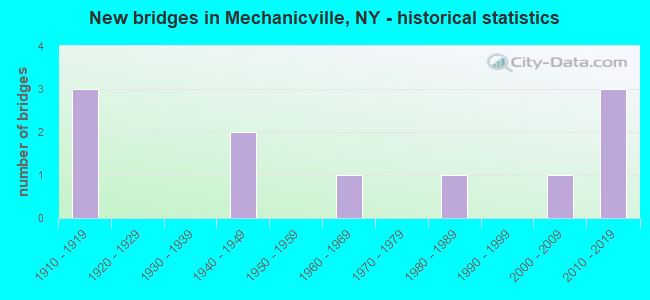
- New bridges - historical statistics
- 31910-1919
- 21940-1949
- 11960-1969
- 11980-1989
- 12000-2009
- 32010-2019

- Reconstructed bridges - Historical Statistics
- 12000-2009
- 22010-2019


- Bridge Condition - Deck
- 57.1%Excellent
- 14.3%Good
- 14.3%Satisfactory
- 14.3%Fair

- Bridge Condition - Superstructure
- 62.5%Excellent
- 12.5%Satisfactory
- 25.0%Fair

- Bridge Condition - Substructure
- 12.5%Excellent
- 37.5%Very good
- 25.0%Good
- 25.0%Satisfactory

- Bridge Condition - Channel
- 33.3%Very good
- 33.3%Good
- 33.3%Fair
Find on map >> Show street view
Structure Number: 107194, Location: CITY OF MECHANICVILLE (Lat: 42.909222, Lng: -73.687150), Route carried "on" structure: State highway 67, Year Built: 1982, Year Reconstructed: 2016, Status: Open, Structure Length: 2.47m (8.10ft), Average Daily Traffic: 4,941 (year 2018), Truck Traffic: 7%, Average Future Daily Traffic: 6,002 (year 2040), Design Load: HL 93, Features Intersected: BOSTON & MAINE
Minimum Vertical Clearance: 30+ m (98+ ft), Kilometerpoint: 41.512, Lanes on structure: 3, Base Highway Network: Yes, Owner: City or Municipal Highway Agency, Approaching Roadway Width: 16.5m (54.1ft), Skew: 24 degrees, Material/Design: Prestressed concrete, Design/Construction: Box Beam or Girders - Multiple, Number Of Spans In Main Unit: 1, Length of Maximum Span: 23.7m (77.8ft), Curb or Sidewalk Widths: Left: 2.4m (7.9ft), Right: 2.4m (7.9ft), Curb-To-Curb Width: 16.5m (54.1ft), Out-to-Out Width: 22.5m (73.8ft)
Condition: Deck: Excellent, Superstructure: Excellent, Substructure: Excellent, Operating Rating: 97.2 metric tons, Method Used To Determine Operating Rating: Load and Resistance Factor Rating (LRFR) rating reported by rating factor(RF) method using HL-93 loadings, Inventory Rating: 80.4 metric tons, Method Used To Determine Inventory Rating: Load and Resistance Factor Rating (LRFR) rating reported by rating factor(RF) method using HL-93 loadings, Structural Evaluation: Superior to present desirable criteria, Deck Geometry: Better than present minimum criteria, Underclear: Somewhat better than minimum adequacy, Approach Roadway Alignment: Equal to present desirable criteria, Length Of Structure Improvement: 2.46m (8.07ft), Designated Inspection Frequency: Every 24 months, Inspection Date: September 2020, Bridge Improvement Cost: $1,535,000, Roadway Improvement Cost: $899,000, Total Project Cost: $2,434,000 ( Estimate for 2021), Deck Structure Type: Concrete Cast-file-Place, Wearing Surface/Protective System: Wearing Surface: Integral Concrete, Deck Protection: Epoxy Coated Reinforcing
Find on map >> Show street view
Structure Number: 220294, Location: N.MAIN ST. MECHANICVILLE (Lat: 42.903692, Lng: -73.685928), Route carried "on" structure: City street , Year Built: 2015, Status: Open, Structure Length: 1.19m (3.90ft), Average Daily Traffic: 4,398 (year 2020), Truck Traffic: 4%, Average Future Daily Traffic: 5,342 (year 2040), Design Load: HL 93, Features Intersected: ANTHONY KILL, Facility Carried by Structure: NORTH MAIN STREET
Minimum Vertical Clearance: 30+ m (98+ ft), Kilometerpoint: 0.097, Lanes on structure: 2, Owner: City or Municipal Highway Agency, Approaching Roadway Width: 11.0m (36.1ft), Skew: 1 degrees, Material/Design: Steel, Design/Construction: Stringer/Multi-beam, Number Of Spans In Main Unit: 1, Length of Maximum Span: 9.8m (32.2ft), Curb or Sidewalk Widths: Left: 1.2m (3.9ft), Right: 2.3m (7.5ft), Curb-To-Curb Width: 11.0m (36.1ft), Out-to-Out Width: 15.8m (51.8ft)
Condition: Deck: Excellent, Superstructure: Excellent, Substructure: Very good, Channel: Very good, Operating Rating: 65.3 metric tons, Method Used To Determine Operating Rating: Load Factor (LF), Inventory Rating: 39.0 metric tons, Method Used To Determine Inventory Rating: Load Factor (LF), Structural Evaluation: Equal to present desirable criteria, Deck Geometry: Somewhat better than minimum adequacy, Waterway Adequacy: Equal to present minimum criteria, Approach Roadway Alignment: Somewhat better than minimum adequacy, Length Of Structure Improvement: 1.18m (3.87ft), Designated Inspection Frequency: Every 24 months, Inspection Date: August 2021, Bridge Improvement Cost: $803,000, Roadway Improvement Cost: $470,000, Total Project Cost: $1,274,000 ( Estimate for 2021), Deck Structure Type: Concrete Cast-file-Place, Wearing Surface/Protective System: Wearing Surface: Monolithic Concrete, Deck Protection: Epoxy Coated Reinforcing
Find on map >> Show street view
Structure Number: 220295, Location: CITY OF MECHANICVILLE (Lat: 42.904983, Lng: -73.685089), Route carried "on" structure: City street , Year Built: 2016, Status: Open, Structure Length: 1.68m (5.51ft), Average Daily Traffic: 298 (year 2016), Truck Traffic: 5%, Average Future Daily Traffic: 417 (year 2036), Design Load: HL 93, Features Intersected: ANTHONY KILL, Facility Carried by Structure: FRANCES STREET
Minimum Vertical Clearance: 30+ m (98+ ft), Kilometerpoint: 0.032, Lanes on structure: 2, Owner: City or Municipal Highway Agency, Approaching Roadway Width: 7.3m (24.0ft), Skew: 1 degrees, Material/Design: Steel, Design/Construction: Stringer/Multi-beam, Number Of Spans In Main Unit: 1, Length of Maximum Span: 14.9m (48.9ft), Curb or Sidewalk Widths: Left: 1.6m (5.2ft), Right: 1.6m (5.2ft), Curb-To-Curb Width: 7.3m (24.0ft), Out-to-Out Width: 11.6m (38.1ft)
Condition: Deck: Excellent, Superstructure: Excellent, Substructure: Very good, Channel: Fair, Operating Rating: 64.4 metric tons, Method Used To Determine Operating Rating: Load Factor (LF), Inventory Rating: 38.1 metric tons, Method Used To Determine Inventory Rating: Load Factor (LF), Structural Evaluation: Equal to present desirable criteria, Deck Geometry: Somewhat better than minimum adequacy, Waterway Adequacy: High priority of corrective action, Approach Roadway Alignment: Meets minimum limits, Length Of Structure Improvement: 1.67m (5.48ft), Designated Inspection Frequency: Every 24 months, Inspection Date: June 2020, Bridge Improvement Cost: $577,000, Roadway Improvement Cost: $338,000, Total Project Cost: $915,000 ( Estimate for 2021), Deck Structure Type: Concrete Cast-file-Place, Wearing Surface/Protective System: Wearing Surface: Integral Concrete, Deck Protection: Epoxy Coated Reinforcing
Find on map >> Show street view
Structure Number: 220296, Location: CITY OF MECHANICVILLE (Lat: 42.906522, Lng: -73.687847), Route carried "on" structure: City street 4, Year Built: 2014, Status: Open, Structure Length: 1.31m (4.30ft), Average Daily Traffic: 11,558 (year 2017), Truck Traffic: 5%, Average Future Daily Traffic: 14,040 (year 2040), Design Load: HL 93, Features Intersected: ANTHONY KILL
Minimum Vertical Clearance: 30+ m (98+ ft), Kilometerpoint: 14.143, Lanes on structure: 2, Base Highway Network: Yes, Owner: City or Municipal Highway Agency, Approaching Roadway Width: 13.4m (44.0ft), Material/Design: Concrete, Design/Construction: Arch - Deck, Number Of Spans In Main Unit: 1, Length of Maximum Span: 12.8m (42.0ft), Curb or Sidewalk Widths: Left: 1.6m (5.2ft), Right: 1.6m (5.2ft), Curb-To-Curb Width: 13.4m (44.0ft), Out-to-Out Width: 18.0m (59.1ft)
Condition: Superstructure: Excellent, Substructure: Very good, Channel: Good, Operating Rating: 81.6 metric tons, Method Used To Determine Operating Rating: Field evaluation and documented engineering judgment, Inventory Rating: 40.8 metric tons, Method Used To Determine Inventory Rating: Field evaluation and documented engineering judgment, Structural Evaluation: Equal to present desirable criteria, Deck Geometry: Equal to present minimum criteria, Waterway Adequacy: Equal to present minimum criteria, Approach Roadway Alignment: Equal to present desirable criteria, Length Of Structure Improvement: 1.31m (4.30ft), Designated Inspection Frequency: Every 24 months, Inspection Date: August 2020, Bridge Improvement Cost: $450,000, Roadway Improvement Cost: $263,000, Total Project Cost: $713,000 ( Estimate for 2021), Wearing Surface/Protective System: Wearing Surface: Bituminous
Find on map >> Show street view
Structure Number: 220297, Location: CITY OF MECHANICVILLE (Lat: 42.909397, Lng: -73.691531), Route carried "on" structure: City street , Year Built: 1946, Status: Open, Structure Length: 1.46m (4.79ft), Average Daily Traffic: 3,731 (year 2017), Truck Traffic: 2%, Average Future Daily Traffic: 4,616 (year 2040), Features Intersected: ANTHONY KILL, Facility Carried by Structure: VIALL AVENUE
Minimum Vertical Clearance: 30+ m (98+ ft), Kilometerpoint: 0.241, Lanes on structure: 2, Owner: County Highway Agency, Approaching Roadway Width: 10.7m (35.1ft), Skew: 3 degrees, Material/Design: Concrete, Design/Construction: Arch - Deck, Number Of Spans In Main Unit: 1, Length of Maximum Span: 12.1m (39.7ft), Curb or Sidewalk Widths: Left: 2.0m (6.6ft), Right: 1.9m (6.2ft), Curb-To-Curb Width: 10.6m (34.8ft), Out-to-Out Width: 15.3m (50.2ft)
Condition: Deck: Fair, Superstructure: Fair, Substructure: Satisfactory, Channel: Fair, Operating Rating: 57.6 metric tons, Method Used To Determine Operating Rating: Field evaluation and documented engineering judgment, Inventory Rating: 15.1 metric tons, Method Used To Determine Inventory Rating: Field evaluation and documented engineering judgment, Structural Evaluation: Meets minimum limits, Deck Geometry: Somewhat better than minimum adequacy, Waterway Adequacy: Equal to present desirable criteria, Approach Roadway Alignment: Better than present minimum criteria, Length Of Structure Improvement: 1.46m (4.79ft), Designated Inspection Frequency: Every 24 months, Inspection Date: April 2020, Bridge Improvement Cost: $428,000, Roadway Improvement Cost: $251,000, Total Project Cost: $679,000 ( Estimate for 2021), Deck Structure Type: Other, Wearing Surface/Protective System: Wearing Surface: Bituminous
Find on map >> Show street view
Structure Number: 225947, Location: 3.2 MI SW OF SCHAGHTICOKE (Lat: 42.880228, Lng: -73.643131), Route carried "on" structure: Other road , Year Built: 2004, Status: Open, Structure Length: 3.05m (10.01ft), Average Daily Traffic: 177 (year 2018), Truck Traffic: 5%, Average Future Daily Traffic: 248 (year 2038), Design Load: HS 25 or greater, Features Intersected: SPRINGFIELD TRML, Facility Carried by Structure: HANSEN ROAD
Minimum Vertical Clearance: 30+ m (98+ ft), Kilometerpoint: 2.381, Lanes on structure: 2, Owner: Railroad, Approaching Roadway Width: 7.3m (24.0ft), Skew: 2 degrees, Material/Design: Prestressed concrete, Design/Construction: Box Beam or Girders - Multiple, Number Of Spans In Main Unit: 1, Length of Maximum Span: 29.8m (97.8ft), Curb-To-Curb Width: 7.8m (25.6ft), Out-to-Out Width: 8.9m (29.2ft)
Condition: Deck: Satisfactory, Superstructure: Satisfactory, Substructure: Satisfactory, Operating Rating: 97.2 metric tons, Method Used To Determine Operating Rating: Load and Resistance Factor Rating (LRFR) rating reported by rating factor(RF) method using HL-93 loadings, Inventory Rating: 79.1 metric tons, Method Used To Determine Inventory Rating: Load and Resistance Factor Rating (LRFR) rating reported by rating factor(RF) method using HL-93 loadings, Structural Evaluation: Equal to present minimum criteria, Deck Geometry: Somewhat better than minimum adequacy, Underclear: Superior to present desirable criteria, Approach Roadway Alignment: Equal to present desirable criteria, Length Of Structure Improvement: 3.04m (9.97ft), Designated Inspection Frequency: Every 24 months, Inspection Date: March 2021, Bridge Improvement Cost: $1,386,000, Roadway Improvement Cost: $812,000, Total Project Cost: $2,198,000 ( Estimate for 2021), Deck Structure Type: Concrete Cast-file-Place, Wearing Surface/Protective System: Wearing Surface: Integral Concrete, Deck Protection: Epoxy Coated Reinforcing
Find on map >> Show street view
Structure Number: 330482, Location: CITY OF MECHANICVILLE (Lat: 42.911708, Lng: -73.698419), Route carried "on" structure: City street , Year Built: 1967, Year Reconstructed: 2015, Status: Open, Structure Length: 1.31m (4.30ft), Average Daily Traffic: 471 (year 2017), Truck Traffic: 4%, Average Future Daily Traffic: 659 (year 2037), Design Load: H 20, Features Intersected: ANTHONY KILL, Facility Carried by Structure: ROUND LAKE AVE
Minimum Vertical Clearance: 30+ m (98+ ft), Kilometerpoint: 0.644, Lanes on structure: 2, Owner: County Highway Agency, Approaching Roadway Width: 8.8m (28.9ft), Material/Design: Prestressed concrete, Design/Construction: Box Beam or Girders - Multiple, Number Of Spans In Main Unit: 1, Length of Maximum Span: 12.8m (42.0ft), Curb-To-Curb Width: 8.9m (29.2ft), Out-to-Out Width: 9.9m (32.5ft)
Condition: Deck: Excellent, Superstructure: Excellent, Substructure: Good, Channel: Good, Operating Rating: 89.8 metric tons, Method Used To Determine Operating Rating: Load Factor (LF), Inventory Rating: 47.2 metric tons, Method Used To Determine Inventory Rating: Load Factor (LF), Structural Evaluation: Better than present minimum criteria, Deck Geometry: Somewhat better than minimum adequacy, Waterway Adequacy: Superior to present desirable criteria, Approach Roadway Alignment: Meets minimum limits, Length Of Structure Improvement: 1.31m (4.30ft), Designated Inspection Frequency: Every 24 months, Inspection Date: October 2021, Bridge Improvement Cost: $464,000, Roadway Improvement Cost: $272,000, Total Project Cost: $736,000 ( Estimate for 2021), Wearing Surface/Protective System: Wearing Surface: Bituminous, Membrane: Preformed Fabric
Find on map >> Show street view
Structure Number: 441515, Location: JCT.RT 67 & CHAMPL. CANAL (Lat: 42.905703, Lng: -73.683297), Route carried "on" structure: State highway 67, Year Built: 1946, Year Reconstructed: 2009, Status: Open, Structure Length: 17.68m (58.01ft), Average Daily Traffic: 5,822 (year 2020), Truck Traffic: 6%, Average Future Daily Traffic: 7,072 (year 2040), Design Load: HS 20, Features Intersected: CHAMPLAIN CANAL, HUDSON
Minimum Vertical Clearance: 4.52m (14.83ft), Kilometerpoint: 42.301, Lanes on structure: 2, Base Highway Network: Yes, Owner: State Highway Agency, Approaching Roadway Width: 6.7m (22.0ft), Navigation Control: Yes ( Vertical Clearance: 6.7m (22.0ft), Horizontal Clearance: 30.1m (98.8ft)), Material/Design: Steel, Design/Construction: Truss - Thru, Number Of Spans In Main Unit: 1, Number Of Approach Spans: 4, Length of Maximum Span: 73.2m (240.2ft), Curb or Sidewalk Widths: Left: 1.1m (3.6ft), Right: 1.1m (3.6ft), Curb-To-Curb Width: 6.7m (22.0ft), Out-to-Out Width: 7.9m (25.9ft)
Condition: Deck: Good, Superstructure: Fair, Substructure: Good, Channel: Very good, Operating Rating: 31.1 metric tons, Method Used To Determine Operating Rating: Load and Resistance Factor Rating (LRFR) rating reported by rating factor(RF) method using HL-93 loadings, Inventory Rating: 24.0 metric tons, Method Used To Determine Inventory Rating: Load and Resistance Factor Rating (LRFR) rating reported by rating factor(RF) method using HL-93 loadings, Structural Evaluation: Somewhat better than minimum adequacy, Deck Geometry: High priority of replacement, Waterway Adequacy: Equal to present minimum criteria, Approach Roadway Alignment: Equal to present minimum criteria, Length Of Structure Improvement: 17.67m (57.97ft), Designated Inspection Frequency: Every 24 months, Critical Feature Inspection Frequency: Every 12 months, Underwater Inspection Frequency: Every 60 months, Inspection Date: September 2021, Critical Feature Inspection Date: September 2021, Underwater Inspection Date: July 2021, Bridge Improvement Cost: $8,955,000, Roadway Improvement Cost: $5,244,000, Total Project Cost: $14,198,000 ( Estimate for 2021), Deck Structure Type: Concrete Cast-file-Place, Wearing Surface/Protective System: Wearing Surface: Integral Concrete, Deck Protection: Epoxy Coated Reinforcing
Find on map >> Show street view
Structure Number: 441502, Location: JCT B&M RR & CHAMPLAIN C (Lat: 42.920531, Lng: -73.673464), Route carried "under" structure: US 4, Year Built: 1914, Structure Length: 0. m, Average Daily Traffic: 9,494 (year 2000), Features Intersected: RTE 4, HUDSON R&CHAMPCNL, Facility Carried by Structure: B&M RAILROAD
Minimum Vertical Clearance: 7.14m (23.43ft), Kilometerpoint: 1.126, Lanes under structure: 2, Material/Design: Steel, Design/Construction: Truss - Deck, Length of Maximum Span: 40.5m (132.9ft)
Find on map >> Show street view
Structure Number: 700097, Location: OVER US4 IN MECHANICVILLE (Lat: 42.901847, Lng: -73.688967), Route carried "under" structure: US 4, Year Built: 1914, Structure Length: 0. m, Average Daily Traffic: 12,825 (year 2000), Features Intersected: RTE 4, Facility Carried by Structure: DELAWARE & HUDSON
Minimum Vertical Clearance: 4.47m (14.67ft), Kilometerpoint: 1.158, Lanes under structure: 4, Material/Design: Steel, Design/Construction: Girder and Floorbeam System, Length of Maximum Span: 23.2m (76.1ft)
Find on map >> Show street view
Structure Number: 720293, Location: CITY OF MECHANICVILLE (Lat: 42.900058, Lng: -73.688394), Route carried "under" structure: City street , Year Built: 1911, Structure Length: 0. m, Average Daily Traffic: 2,432 (year 2019), Truck Traffic: 2%, Features Intersected: ELLSWORTH AVENUE, Facility Carried by Structure: DELAWARE & HUDSON
Minimum Vertical Clearance: 2.23m (7.32ft), Kilometerpoint: 0.338, Lanes under structure: 2, Material/Design: Steel, Design/Construction: Girder and Floorbeam System, Length of Maximum Span: 11.2m (36.7ft)