Bridge Statistics for Medford, Massachusetts (MA)
Condition, Traffic, Stress, Structural Evaluation, Project Costs
- National Bridge Inventory (NBI) Statistics
- 30Number of bridges
- 456ft / 139mTotal length
- $162,182,000Total costs
- 2,321,505Total average daily traffic
- 187,898Total average daily truck traffic
- National Bridge Inventory (NBI) Registered Bridges for Medford
- No street view available for this location
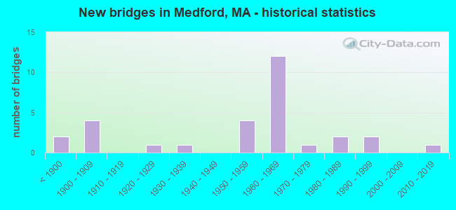
- New bridges - historical statistics
- 2Before 1900
- 41900-1909
- 11920-1929
- 11930-1939
- 41950-1959
- 121960-1969
- 11970-1979
- 21980-1989
- 21990-1999
- 12010-2019

- Reconstructed bridges - Historical Statistics
- 11950-1959
- 01960-1969
- 11970-1979
- 11980-1989
- 11990-1999
- 72000-2009
- 12010-2019


- Bridge Condition - Deck
- 4.0%Very good
- 16.0%Good
- 24.0%Satisfactory
- 56.0%Fair

- Bridge Condition - Superstructure
- 7.1%Very good
- 25.0%Good
- 28.6%Satisfactory
- 35.7%Fair
- 3.6%Poor

- Bridge Condition - Substructure
- 3.6%Very good
- 10.7%Good
- 46.4%Satisfactory
- 35.7%Fair
- 3.6%Poor

- Bridge Condition - Channel
- 75.0%Good
- 12.5%Fair
- 12.5%Poor
Find on map >> Show street view
Structure Number: M120014DXDOTNBI, Location: .3 MI S OF ST RTE 16 (Lat: 42.399711, Lng: -71.083603), Route carried "on" structure: State highway 28, Year Built: 1935, Year Reconstructed: 1979, Status: Open, Structure Length: 21.95m (72.01ft), Average Daily Traffic: 64,248 (year 2018), Truck Traffic: 10%, Average Future Daily Traffic: 148,454 (year 2032), Design Load: HS 20, Features Intersected: WATER MYSTIC RIVER
Minimum Vertical Clearance: 30+ m (98+ ft), Kilometerpoint: 0.016, Lanes on structure: 6, Base Highway Network: Yes, Owner: State Highway Agency, Approaching Roadway Width: 24.7m (81.0ft), Skew: 20 degrees, Navigation Control: Yes ( Vertical Clearance: 50.3m (165.0ft), Horizontal Clearance: 15.2m (49.9ft)), Material/Design: Steel, Design/Construction: Stringer/Multi-beam, Number Of Spans In Main Unit: 14, Length of Maximum Span: 18.3m (60.0ft), Curb or Sidewalk Widths: Left: 1.4m (4.6ft), Right: 1.4m (4.6ft), Curb-To-Curb Width: 24.4m (80.1ft), Out-to-Out Width: 29.3m (96.1ft)
Condition: Deck: Fair, Superstructure: Fair, Substructure: Fair, Channel: Fair, Operating Rating: 61.7 metric tons, Method Used To Determine Operating Rating: Load Factor (LF), Inventory Rating: 36.9 metric tons, Method Used To Determine Inventory Rating: Load Factor (LF), Structural Evaluation: Somewhat better than minimum adequacy, Deck Geometry: Somewhat better than minimum adequacy, Waterway Adequacy: Equal to present desirable criteria, Approach Roadway Alignment: Equal to present desirable criteria, Length Of Structure Improvement: 22.00m (72.18ft), Designated Inspection Frequency: Every 24 months, Underwater Inspection Frequency: Every 36 months, Inspection Date: May 2021, Underwater Inspection Date: September 2021, Bridge Improvement Cost: $25,320,000, Roadway Improvement Cost: $2,533,000, Total Project Cost: $37,981,000 ( Estimate for 2022), Deck Structure Type: Concrete Cast-file-Place, Wearing Surface/Protective System: Wearing Surface: Bituminous, Membrane: Preformed Fabric, Deck Protection: Cathodic Protection
Find on map >> Show street view
Structure Number: M120024E0DOTNBI, Location: .1 MI N OF ST16 (Lat: 42.417569, Lng: -71.110192), Route carried "on" structure: State highway 38, Year Built: 1908, Year Reconstructed: 2018, Status: Open, Structure Length: 2.77m (9.09ft), Average Daily Traffic: 67,900 (year 2019), Truck Traffic: 6%, Average Future Daily Traffic: 66,331 (year 2032), Design Load: HL 93, Features Intersected: WATER MYSTIC RIVER
Minimum Vertical Clearance: 30+ m (98+ ft), Kilometerpoint: 2.446, Lanes on structure: 2, Owner: State Highway Agency, Approaching Roadway Width: 14.9m (48.9ft), Skew: 20 degrees, Material/Design: Masonry, Design/Construction: Arch - Deck, Number Of Spans In Main Unit: 2, Number Of Approach Spans: 1, Length of Maximum Span: 8.0m (26.2ft), Curb or Sidewalk Widths: Left: 3.3m (10.8ft), Right: 2.2m (7.2ft), Curb-To-Curb Width: 15.8m (51.8ft), Out-to-Out Width: 22.5m (73.8ft)
Condition: Deck: Very good, Superstructure: Good, Substructure: Good, Channel: Good, Operating Rating: 42.1 metric tons, Method Used To Determine Operating Rating: Assigned ratings based on Load and Resistance Factor Design (LRFD) reported by rating factor (RF) using HL93 loadings, Inventory Rating: 32.4 metric tons, Method Used To Determine Inventory Rating: Assigned ratings based on Load and Resistance Factor Design (LRFD) reported by rating factor (RF) using HL93 loadings, Structural Evaluation: Better than present minimum criteria, Deck Geometry: Superior to present desirable criteria, Waterway Adequacy: Equal to present minimum criteria, Approach Roadway Alignment: Better than present minimum criteria, Designated Inspection Frequency: Every 24 months, Underwater Inspection Frequency: Every 60 months, Inspection Date: May 2021, Underwater Inspection Date: April 2019, Deck Structure Type: Concrete Cast-file-Place, Wearing Surface/Protective System: Wearing Surface: Bituminous
Find on map >> Show street view
Structure Number: M120034DTDOTNBI, Location: .2 MI E OF WINTHROP ST (Lat: 42.418033, Lng: -71.112600), Route carried "on" structure: State highway 16, Year Built: 1906, Status: Open, Structure Length: 1.95m (6.40ft), Average Daily Traffic: 50,400 (year 2016), Truck Traffic: 9%, Average Future Daily Traffic: 83,703 (year 2031), Features Intersected: WATER MYSTIC RIVER
Minimum Vertical Clearance: 30+ m (98+ ft), Kilometerpoint: 1.239, Lanes on structure: 2, Base Highway Network: Yes, Owner: State Highway Agency, Approaching Roadway Width: 14.6m (47.9ft), Skew: 20 degrees, Material/Design: Concrete, Design/Construction: Arch - Deck, Number Of Spans In Main Unit: 1, Length of Maximum Span: 19.5m (64.0ft), Curb or Sidewalk Widths: Left: 1.8m (5.9ft), Right: 1.8m (5.9ft), Curb-To-Curb Width: 14.6m (47.9ft), Out-to-Out Width: 19.2m (63.0ft)
Condition: Superstructure: Satisfactory, Substructure: Satisfactory, Channel: Good, Inventory Rating: 59.9 metric tons, Method Used To Determine Inventory Rating: Load Factor (LF), Structural Evaluation: Equal to present minimum criteria, Deck Geometry: Superior to present desirable criteria, Waterway Adequacy: Somewhat better than minimum adequacy, Approach Roadway Alignment: Somewhat better than minimum adequacy, Length Of Structure Improvement: 2.00m (6.56ft), Designated Inspection Frequency: Every 24 months, Underwater Inspection Frequency: Every 36 months, Inspection Date: July 2020, Underwater Inspection Date: December 2019, Bridge Improvement Cost: $302,000, Roadway Improvement Cost: $31,000, Total Project Cost: $454,000 ( Estimate for 2022)
Find on map >> Show street view
Structure Number: M120043F4DOTNBI, Location: 1.1 KM W OF JCT I93&SR60 (Lat: 42.417747, Lng: -71.117939), Route carried "on" structure: State highway 38, Year Built: 1926, Status: Posted for load, Structure Length: 2.19m (7.19ft), Average Daily Traffic: 14,900 (year 2019), Truck Traffic: 6%, Average Future Daily Traffic: 18,320 (year 2032), Features Intersected: WATER MYSTIC RIVER, Facility Carried by Structure: HWY WINTHROP ST
Minimum Vertical Clearance: 30+ m (98+ ft), Kilometerpoint: 0.000, Lanes on structure: 2, Owner: State Highway Agency, Approaching Roadway Width: 12.2m (40.0ft), Material/Design: Concrete continuous, Design/Construction: Tee Beam, Number Of Spans In Main Unit: 3, Length of Maximum Span: 6.7m (22.0ft), Curb or Sidewalk Widths: Left: 1.5m (4.9ft), Right: 1.5m (4.9ft), Curb-To-Curb Width: 12.2m (40.0ft), Out-to-Out Width: 16.2m (53.1ft)
Condition: Deck: Fair, Superstructure: Poor, Substructure: Poor, Channel: Poor, Operating Rating: 34.1 metric tons, Method Used To Determine Operating Rating: Load Factor (LF), Inventory Rating: 27.9 metric tons, Method Used To Determine Inventory Rating: Load Factor (LF), Structural Evaluation: Meets minimum limits, Deck Geometry: Somewhat better than minimum adequacy, Waterway Adequacy: Better than present minimum criteria, Approach Roadway Alignment: Equal to present minimum criteria, Length Of Structure Improvement: 3.00m (9.84ft), Designated Inspection Frequency: Every 12 months, Underwater Inspection Frequency: Every 12 months, Other Special Inspection Frequency: Every 12 months, Inspection Date: May 2021, Underwater Inspection Date: May 2021, Other Special Inspection Date: May 2021, Bridge Improvement Cost: $2,735,000, Roadway Improvement Cost: $274,000, Total Project Cost: $4,103,000 ( Estimate for 2022), Deck Structure Type: Concrete Cast-file-Place, Wearing Surface/Protective System: Wearing Surface: Bituminous
Find on map >> Show street view
Structure Number: M120054DUDOTNBI, Location: .4 MI W OF WINTHROP ST (Lat: 42.418158, Lng: -71.126761), Route carried "on" structure: State highway 16, Year Built: 1906, Status: Open, Structure Length: 1.83m (6.00ft), Average Daily Traffic: 33,900 (year 2021), Truck Traffic: 2%, Average Future Daily Traffic: 43,352 (year 2032), Features Intersected: WATER MYSTIC RIVER
Minimum Vertical Clearance: 30+ m (98+ ft), Kilometerpoint: 84.553, Lanes on structure: 4, Base Highway Network: Yes, Owner: State Highway Agency, Approaching Roadway Width: 12.2m (40.0ft), Material/Design: Concrete, Design/Construction: Arch - Deck, Number Of Spans In Main Unit: 1, Length of Maximum Span: 18.3m (60.0ft), Curb or Sidewalk Widths: Left: 3.2m (10.5ft), Right: 3.2m (10.5ft), Curb-To-Curb Width: 15.1m (49.5ft), Out-to-Out Width: 22.3m (73.2ft)
Condition: Superstructure: Satisfactory, Substructure: Satisfactory, Channel: Good, Operating Rating: 91.7 metric tons, Method Used To Determine Operating Rating: Load Factor (LF), Inventory Rating: 54.9 metric tons, Method Used To Determine Inventory Rating: Load Factor (LF), Structural Evaluation: Equal to present minimum criteria, Deck Geometry: High priority of corrective action, Waterway Adequacy: Better than present minimum criteria, Approach Roadway Alignment: Meets minimum limits, Length Of Structure Improvement: 1.90m (6.23ft), Designated Inspection Frequency: Every 24 months, Underwater Inspection Frequency: Every 24 months, Inspection Date: October 2021, Underwater Inspection Date: Febuary 2021, Bridge Improvement Cost: $1,254,000, Roadway Improvement Cost: $126,000, Total Project Cost: $1,882,000 ( Estimate for 2022), Wearing Surface/Protective System: Wearing Surface: Bituminous, Membrane: Preformed Fabric
Find on map >> Show street view
Structure Number: M1200637GMUNNBI, Location: JUST NW OF RTE 16 (Lat: 42.417319, Lng: -71.130514), Route carried "on" structure: City street , Year Built: 1900, Status: Open, Structure Length: 2.10m (6.89ft), Average Daily Traffic: 10,600 (year 2019), Truck Traffic: 10%, Average Future Daily Traffic: 26,216 (year 2032), Features Intersected: WATER MYSTIC RIVER, Facility Carried by Structure: HWY BOSTON AVE
Minimum Vertical Clearance: 30+ m (98+ ft), Kilometerpoint: 0.016, Lanes on structure: 2, Owner: City or Municipal Highway Agency, Approaching Roadway Width: 12.2m (40.0ft), Navigation Control: Yes ( Vertical Clearance: 1.5m (4.9ft), Horizontal Clearance: 15.2m (49.9ft)), Material/Design: Masonry, Design/Construction: Arch - Deck, Number Of Spans In Main Unit: 1, Length of Maximum Span: 21.0m (68.9ft), Curb or Sidewalk Widths: Left: 2.4m (7.9ft), Right: 2.4m (7.9ft), Curb-To-Curb Width: 12.2m (40.0ft), Out-to-Out Width: 17.7m (58.1ft)
Condition: Superstructure: Satisfactory, Substructure: Good, Channel: Good, Operating Rating: 45.1 metric tons, Method Used To Determine Operating Rating: Load Factor (LF), Inventory Rating: 45.1 metric tons, Method Used To Determine Inventory Rating: Load Factor (LF), Structural Evaluation: Equal to present minimum criteria, Deck Geometry: Somewhat better than minimum adequacy, Waterway Adequacy: Superior to present desirable criteria, Approach Roadway Alignment: Better than present minimum criteria, Length Of Structure Improvement: 2.20m (7.22ft), Designated Inspection Frequency: Every 24 months, Underwater Inspection Frequency: Every 36 months, Inspection Date: March 2021, Underwater Inspection Date: July 2021, Bridge Improvement Cost: $249,000, Roadway Improvement Cost: $25,000, Total Project Cost: $374,000 ( Estimate for 2022), Wearing Surface/Protective System: Wearing Surface: Bituminous
Find on map >> Show street view
Structure Number: M120084DVDOTNBI, Location: AT RAILROAD (Lat: 42.414169, Lng: -71.084467), Route carried "on" structure: State highway 28, Year Built: 1850, Year Reconstructed: 1956, Status: Open, Structure Length: 1.07m (3.51ft), Average Daily Traffic: 28,190 (year 2019), Truck Traffic: 2%, Average Future Daily Traffic: 56,065 (year 2032), Features Intersected: RR BMRR
Minimum Vertical Clearance: 30+ m (98+ ft), Kilometerpoint: 1.835, Lanes on structure: 4, Base Highway Network: Yes, Owner: State Highway Agency, Approaching Roadway Width: 24.4m (80.1ft), Skew: 20 degrees, Material/Design: Steel, Design/Construction: Stringer/Multi-beam, Number Of Spans In Main Unit: 1, Length of Maximum Span: 9.1m (29.9ft), Curb or Sidewalk Widths: Left: 1.8m (5.9ft), Right: 1.8m (5.9ft), Curb-To-Curb Width: 24.4m (80.1ft), Out-to-Out Width: 28.9m (94.8ft)
Condition: Deck: Fair, Superstructure: Fair, Substructure: Fair, Operating Rating: 47.1 metric tons, Method Used To Determine Operating Rating: Load Factor (LF), Inventory Rating: 28.2 metric tons, Method Used To Determine Inventory Rating: Load Factor (LF), Structural Evaluation: Somewhat better than minimum adequacy, Deck Geometry: Superior to present desirable criteria, Underclear: High priority of corrective action, Approach Roadway Alignment: Somewhat better than minimum adequacy, Length Of Structure Improvement: 1.10m (3.61ft), Designated Inspection Frequency: Every 24 months, Inspection Date: November 2021, Bridge Improvement Cost: $1,249,000, Roadway Improvement Cost: $125,000, Total Project Cost: $1,874,000 ( Estimate for 2022), Deck Structure Type: Concrete Cast-file-Place, Wearing Surface/Protective System: Wearing Surface: Bituminous
Find on map >> Show street view
Structure Number: M12012AN4DOT634, Location: 1.6 KM W JCT I93&SR16 (Lat: 42.407378, Lng: -71.116389), Route carried "on" structure: City street , Year Built: 1997, Status: Open, Structure Length: 2.54m (8.33ft), Average Daily Traffic: 14,100 (year 2019), Truck Traffic: 7%, Average Future Daily Traffic: 16,741 (year 2032), Design Load: HS 20, Features Intersected: RR MBTA/BMRR, Facility Carried by Structure: HWY COLLEGE AVE
Minimum Vertical Clearance: 30+ m (98+ ft), Kilometerpoint: 0.193, Lanes on structure: 2, Owner: State Highway Agency, Approaching Roadway Width: 9.5m (31.2ft), Skew: 2 degrees, Material/Design: Prestressed concrete, Design/Construction: Box Beam or Girders - Multiple, Number Of Spans In Main Unit: 1, Length of Maximum Span: 22.4m (73.5ft), Curb or Sidewalk Widths: Left: 1.9m (6.2ft), Right: 1.4m (4.6ft), Curb-To-Curb Width: 9.5m (31.2ft), Out-to-Out Width: 13.8m (45.3ft)
Condition: Deck: Fair, Superstructure: Fair, Substructure: Good, Operating Rating: 44.6 metric tons, Method Used To Determine Operating Rating: Allowable Stress (AS), Inventory Rating: 32.6 metric tons, Method Used To Determine Inventory Rating: Allowable Stress (AS), Structural Evaluation: Somewhat better than minimum adequacy, Deck Geometry: High priority of corrective action, Underclear: High priority of corrective action, Approach Roadway Alignment: Equal to present minimum criteria, Length Of Structure Improvement: 2.60m (8.53ft), Designated Inspection Frequency: Every 24 months, Inspection Date: August 2021, Bridge Improvement Cost: $1,410,000, Roadway Improvement Cost: $142,000, Total Project Cost: $2,116,000 ( Estimate for 2022), Deck Structure Type: Concrete Precast Panels, Wearing Surface/Protective System: Wearing Surface: Bituminous, Membrane: Built-up
Find on map >> Show street view
Structure Number: M120133FYDOT634, Location: 1.9 KM NW OF JCT I93&SR16 (Lat: 42.412061, Lng: -71.121436), Route carried "on" structure: City street , Year Built: 1984, Status: Open, Structure Length: 1.31m (4.30ft), Average Daily Traffic: 20,172 (year 2020), Truck Traffic: 4%, Average Future Daily Traffic: 26,374 (year 2033), Design Load: HS 20, Features Intersected: RR MBTA/BMRR, Facility Carried by Structure: HWY WINTHROP ST
Minimum Vertical Clearance: 30+ m (98+ ft), Kilometerpoint: 0.000, Lanes on structure: 2, Owner: State Highway Agency, Approaching Roadway Width: 10.4m (34.1ft), Skew: 2 degrees, Material/Design: Prestressed concrete, Design/Construction: Box Beam or Girders - Multiple, Number Of Spans In Main Unit: 1, Length of Maximum Span: 11.9m (39.0ft), Curb or Sidewalk Widths: Left: 1.8m (5.9ft), Right: 1.9m (6.2ft), Curb-To-Curb Width: 10.4m (34.1ft), Out-to-Out Width: 14.6m (47.9ft)
Condition: Deck: Fair, Superstructure: Fair, Substructure: Satisfactory, Operating Rating: 52.6 metric tons, Method Used To Determine Operating Rating: Allowable Stress (AS), Inventory Rating: 31.3 metric tons, Method Used To Determine Inventory Rating: Allowable Stress (AS), Structural Evaluation: Somewhat better than minimum adequacy, Deck Geometry: Meets minimum limits, Underclear: High priority of corrective action, Approach Roadway Alignment: Equal to present minimum criteria, Length Of Structure Improvement: 1.40m (4.59ft), Designated Inspection Frequency: Every 24 months, Inspection Date: January 2022, Bridge Improvement Cost: $803,000, Roadway Improvement Cost: $81,000, Total Project Cost: $1,205,000 ( Estimate for 2022), Deck Structure Type: Concrete Precast Panels, Wearing Surface/Protective System: Wearing Surface: Bituminous, Membrane: Built-up
Find on map >> Show street view
Structure Number: M12014AN5DOT634, Location: 1.3 KM SW SR 16 & 38 (Lat: 42.415169, Lng: -71.125181), Route carried "on" structure: State highway , Year Built: 1997, Status: Open, Structure Length: 2.72m (8.92ft), Average Daily Traffic: 4,400 (year 2019), Truck Traffic: 6%, Average Future Daily Traffic: 5,685 (year 2032), Design Load: HS 20, Features Intersected: RR MBTA/BMRR, Facility Carried by Structure: HWY NORTH ST
Minimum Vertical Clearance: 30+ m (98+ ft), Kilometerpoint: 0.370, Lanes on structure: 2, Owner: State Highway Agency, Approaching Roadway Width: 9.8m (32.2ft), Skew: 1 degrees, Material/Design: Prestressed concrete continuous, Design/Construction: Slab, Number Of Spans In Main Unit: 3, Length of Maximum Span: 10.7m (35.1ft), Curb or Sidewalk Widths: Left: 1.8m (5.9ft), Right: 1.8m (5.9ft), Curb-To-Curb Width: 9.8m (32.2ft), Out-to-Out Width: 14.2m (46.6ft)
Condition: Deck: Satisfactory, Superstructure: Satisfactory, Substructure: Satisfactory, Operating Rating: 55.8 metric tons, Method Used To Determine Operating Rating: Allowable Stress (AS), Inventory Rating: 36.9 metric tons, Method Used To Determine Inventory Rating: Allowable Stress (AS), Structural Evaluation: Equal to present minimum criteria, Deck Geometry: Meets minimum limits, Underclear: High priority of replacement, Approach Roadway Alignment: High priority of corrective action, Length Of Structure Improvement: 3.70m (12.14ft), Designated Inspection Frequency: Every 24 months, Inspection Date: July 2021, Bridge Improvement Cost: $3,450,000, Roadway Improvement Cost: $346,000, Total Project Cost: $5,176,000 ( Estimate for 2022), Deck Structure Type: Concrete Precast Panels, Wearing Surface/Protective System: Wearing Surface: Bituminous, Membrane: Built-up, Deck Protection: Epoxy Coated Reinforcing
Find on map >> Show street view
Structure Number: M120153G1DOT634, Location: 1.5 MI W OF JCT SR38&60 (Lat: 42.428164, Lng: -71.141172), Route carried "on" structure: City street , Year Built: 1891, Year Reconstructed: 1996, Status: Open, Structure Length: 3.38m (11.09ft), Average Daily Traffic: 1,100 (year 2020), Average Future Daily Traffic: 4,580 (year 2031), Features Intersected: RR MBTA/BMRR, Facility Carried by Structure: HWY GROVE ST
Minimum Vertical Clearance: 30+ m (98+ ft), Kilometerpoint: 0.805, Lanes on structure: 2, Owner: State Highway Agency, Approaching Roadway Width: 7.3m (24.0ft), Skew: 3 degrees, Material/Design: Steel, Design/Construction: Girder and Floorbeam System, Number Of Spans In Main Unit: 1, Length of Maximum Span: 32.6m (107.0ft), Curb or Sidewalk Widths: Left: 1.8m (5.9ft), Right: 0.0m, Curb-To-Curb Width: 7.3m (24.0ft), Out-to-Out Width: 10.7m (35.1ft)
Condition: Deck: Good, Superstructure: Good, Substructure: Satisfactory, Operating Rating: 50.6 metric tons, Method Used To Determine Operating Rating: Allowable Stress (AS), Inventory Rating: 33.5 metric tons, Method Used To Determine Inventory Rating: Allowable Stress (AS), Structural Evaluation: Equal to present minimum criteria, Deck Geometry: Meets minimum limits, Underclear: High priority of replacement, Approach Roadway Alignment: High priority of replacement, Length Of Structure Improvement: 4.30m (14.11ft), Designated Inspection Frequency: Every 24 months, Critical Feature Inspection Frequency: Every 24 months, Inspection Date: November 2020, Critical Feature Inspection Date: November 2020, Bridge Improvement Cost: $3,784,000, Roadway Improvement Cost: $379,000, Total Project Cost: $5,677,000 ( Estimate for 2022), Deck Structure Type: Concrete Cast-file-Place, Wearing Surface/Protective System: Wearing Surface: Latex Concrete, Membrane: Other, Deck Protection: Epoxy Coated Reinforcing
Find on map >> Show street view
Structure Number: M12017BGBDOTNBI, Location: .2 MI E OF FELLSWAY (Lat: 42.404358, Lng: -71.076969), Route carried "on" structure: State highway 16, Year Built: 2018, Status: Open, Structure Length: 6.29m (20.64ft), Average Daily Traffic: 68,000 (year 2010), Truck Traffic: 10%, Design Load: HL 93, Features Intersected: COMB RIVERS EDGE&MBTA&O
Minimum Vertical Clearance: 30+ m (98+ ft), Kilometerpoint: 89.541, Lanes on structure: 8, Lanes under structure: 2, Owner: State Highway Agency, Approaching Roadway Width: 32.8m (107.6ft), Skew: 30 degrees, Material/Design: Steel continuous, Design/Construction: Stringer/Multi-beam, Number Of Spans In Main Unit: 2, Length of Maximum Span: 37.2m (122.0ft), Curb or Sidewalk Widths: Left: 3.0m (9.8ft), Right: 3.0m (9.8ft), Curb-To-Curb Width: 31.7m (104.0ft), Out-to-Out Width: 40.2m (131.9ft)
Condition: Deck: Good, Superstructure: Very good, Substructure: Very good, Operating Rating: 48.6 metric tons, Method Used To Determine Operating Rating: Load and Resistance Factor Rating (LRFR) rating reported by rating factor(RF) method using HL-93 loadings, Inventory Rating: 35.6 metric tons, Method Used To Determine Inventory Rating: Load and Resistance Factor Rating (LRFR) rating reported by rating factor(RF) method using HL-93 loadings, Structural Evaluation: Equal to present desirable criteria, Deck Geometry: Somewhat better than minimum adequacy, Underclear: Superior to present desirable criteria, Approach Roadway Alignment: Equal to present desirable criteria, Designated Inspection Frequency: Every 24 months, Inspection Date: November 2020, Deck Structure Type: Concrete Cast-file-Place, Wearing Surface/Protective System: Wearing Surface: Bituminous, Membrane: Other, Deck Protection: Epoxy Coated Reinforcing
Find on map >> Show street view
Structure Number: M120194DYDOTNBI, Location: .3 MI E OF ST RTE 38 (Lat: 42.405897, Lng: -71.096417), Route carried "on" structure: State highway 16, Year Built: 1988, Status: Open, Structure Length: 9.38m (30.77ft), Average Daily Traffic: 42,816 (year 2019), Truck Traffic: 8%, Average Future Daily Traffic: 116,868 (year 2031), Design Load: H 20, Features Intersected: COMB MYSTIC R & PED/BKY
Minimum Vertical Clearance: 30+ m (98+ ft), Kilometerpoint: 0.000, Lanes on structure: 4, Base Highway Network: Yes, Owner: State Highway Agency, Approaching Roadway Width: 19.2m (63.0ft), Skew: 23 degrees, Navigation Control: Yes ( Vertical Clearance: 3.7m (12.1ft), Horizontal Clearance: 25.0m (82.0ft)), Material/Design: Steel continuous, Design/Construction: Stringer/Multi-beam, Number Of Spans In Main Unit: 3, Length of Maximum Span: 42.7m (140.1ft), Curb or Sidewalk Widths: Left: 2.7m (8.9ft), Right: 2.7m (8.9ft), Curb-To-Curb Width: 19.2m (63.0ft), Out-to-Out Width: 33.1m (108.6ft)
Condition: Deck: Fair, Superstructure: Satisfactory, Substructure: Satisfactory, Channel: Good, Operating Rating: 65.1 metric tons, Method Used To Determine Operating Rating: Load Factor (LF), Inventory Rating: 40.8 metric tons, Method Used To Determine Inventory Rating: Load Factor (LF), Structural Evaluation: Equal to present minimum criteria, Deck Geometry: Equal to present minimum criteria, Waterway Adequacy: Superior to present desirable criteria, Approach Roadway Alignment: Equal to present minimum criteria, Length Of Structure Improvement: 9.40m (30.84ft), Designated Inspection Frequency: Every 24 months, Underwater Inspection Frequency: Every 36 months, Inspection Date: October 2020, Underwater Inspection Date: April 2020, Bridge Improvement Cost: $12,347,000, Roadway Improvement Cost: $1,235,000, Total Project Cost: $18,521,000 ( Estimate for 2022), Deck Structure Type: Concrete Cast-file-Place, Wearing Surface/Protective System: Wearing Surface: Bituminous, Membrane: Preformed Fabric
Find on map >> Show street view
Structure Number: M120253B5DOTNBI, Location: 1000FT S OF JCT 193&SR60 (Lat: 42.416300, Lng: -71.103981), Route carried "on" structure: Interstate 93, Year Built: 1961, Year Reconstructed: 2011, Status: Open, Structure Length: 6.28m (20.60ft), Average Daily Traffic: 192,388 (year 2018), Truck Traffic: 10%, Average Future Daily Traffic: 275,206 (year 2032), Design Load: HS 20, Features Intersected: HWY RIVERSIDE AVE
Minimum Vertical Clearance: 30+ m (98+ ft), Kilometerpoint: 0.000, Lanes on structure: 8, Lanes under structure: 2, Base Highway Network: Yes, Owner: State Highway Agency, Approaching Roadway Width: 43.0m (141.1ft), Skew: 33 degrees, Material/Design: Steel, Design/Construction: Stringer/Multi-beam, Number Of Spans In Main Unit: 3, Length of Maximum Span: 22.9m (75.1ft), Curb-To-Curb Width: 43.0m (141.1ft), Out-to-Out Width: 44.0m (144.4ft)
Condition: Deck: Satisfactory, Superstructure: Satisfactory, Substructure: Satisfactory, Operating Rating: 51.8 metric tons, Method Used To Determine Operating Rating: Load and Resistance Factor Rating (LRFR) rating reported by rating factor(RF) method using HL-93 loadings, Inventory Rating: 38.9 metric tons, Method Used To Determine Inventory Rating: Load and Resistance Factor Rating (LRFR) rating reported by rating factor(RF) method using HL-93 loadings, Structural Evaluation: Equal to present minimum criteria, Deck Geometry: Superior to present desirable criteria, Underclear: Meets minimum limits, Approach Roadway Alignment: Better than present minimum criteria, Length Of Structure Improvement: 6.30m (20.67ft), Designated Inspection Frequency: Every 24 months, Inspection Date: November 2021, Bridge Improvement Cost: $2,178,000, Roadway Improvement Cost: $218,000, Total Project Cost: $3,268,000 ( Estimate for 2022), Deck Structure Type: Concrete Precast Panels, Wearing Surface/Protective System: Wearing Surface: Bituminous, Membrane: Built-up, Deck Protection: Epoxy Coated Reinforcing
Find on map >> Show street view
Structure Number: M120273B6DOTNBI, Location: 1.1 KM S OF ROSVELT CIR. (Lat: 42.418717, Lng: -71.104078), Route carried "on" structure: Ramp State highway 93, Year Built: 1961, Year Reconstructed: 2011, Status: Open, Structure Length: 4.88m (16.01ft), Average Daily Traffic: 266,500 (year 2017), Truck Traffic: 7%, Average Future Daily Traffic: 275,272 (year 2032), Design Load: HL 93, Features Intersected: ST 60 EB/SALEM ST
Minimum Vertical Clearance: 30+ m (98+ ft), Kilometerpoint: 12.641, Lanes on structure: 8, Lanes under structure: 2, Base Highway Network: Yes, Owner: State Highway Agency, Approaching Roadway Width: 40.0m (131.2ft), Skew: 30 degrees, Material/Design: Steel, Design/Construction: Stringer/Multi-beam, Number Of Spans In Main Unit: 3, Length of Maximum Span: 23.5m (77.1ft), Curb-To-Curb Width: 40.0m (131.2ft), Out-to-Out Width: 42.5m (139.4ft)
Condition: Deck: Satisfactory, Superstructure: Very good, Substructure: Satisfactory, Operating Rating: 51.8 metric tons, Method Used To Determine Operating Rating: Load and Resistance Factor Rating (LRFR) rating reported by rating factor(RF) method using HL-93 loadings, Inventory Rating: 38.9 metric tons, Method Used To Determine Inventory Rating: Load and Resistance Factor Rating (LRFR) rating reported by rating factor(RF) method using HL-93 loadings, Structural Evaluation: Equal to present minimum criteria, Deck Geometry: Superior to present desirable criteria, Underclear: Meets minimum limits, Approach Roadway Alignment: Equal to present desirable criteria, Length Of Structure Improvement: 4.90m (16.08ft), Designated Inspection Frequency: Every 24 months, Inspection Date: December 2021, Bridge Improvement Cost: $1,637,000, Roadway Improvement Cost: $164,000, Total Project Cost: $2,456,000 ( Estimate for 2022), Deck Structure Type: Concrete Precast Panels, Wearing Surface/Protective System: Wearing Surface: Bituminous, Membrane: Built-up, Deck Protection: Epoxy Coated Reinforcing
Find on map >> Show street view
Structure Number: M120283B7DOTNBI, Location: 1.1 KM S OF ROSVELT CIR. (Lat: 42.420078, Lng: -71.103922), Route carried "on" structure: Interstate 93, Year Built: 1961, Year Reconstructed: 2011, Status: Open, Structure Length: 4.88m (16.01ft), Average Daily Traffic: 266,500 (year 2017), Truck Traffic: 7%, Average Future Daily Traffic: 275,272 (year 2032), Design Load: HL 93, Features Intersected: ST 60 WB/SALEM ST
Minimum Vertical Clearance: 30+ m (98+ ft), Kilometerpoint: 12.641, Lanes on structure: 8, Lanes under structure: 2, Base Highway Network: Yes, Owner: State Highway Agency, Approaching Roadway Width: 40.0m (131.2ft), Skew: 30 degrees, Material/Design: Steel, Design/Construction: Stringer/Multi-beam, Number Of Spans In Main Unit: 3, Length of Maximum Span: 23.5m (77.1ft), Curb-To-Curb Width: 40.0m (131.2ft), Out-to-Out Width: 42.5m (139.4ft)
Condition: Deck: Satisfactory, Superstructure: Good, Substructure: Satisfactory, Operating Rating: 61.6 metric tons, Method Used To Determine Operating Rating: Load and Resistance Factor Rating (LRFR) rating reported by rating factor(RF) method using HL-93 loadings, Inventory Rating: 45.4 metric tons, Method Used To Determine Inventory Rating: Load and Resistance Factor Rating (LRFR) rating reported by rating factor(RF) method using HL-93 loadings, Structural Evaluation: Equal to present minimum criteria, Deck Geometry: Superior to present desirable criteria, Underclear: Somewhat better than minimum adequacy, Approach Roadway Alignment: Equal to present desirable criteria, Length Of Structure Improvement: 4.90m (16.08ft), Designated Inspection Frequency: Every 24 months, Inspection Date: December 2021, Bridge Improvement Cost: $1,637,000, Roadway Improvement Cost: $164,000, Total Project Cost: $2,456,000 ( Estimate for 2022), Deck Structure Type: Concrete Precast Panels, Wearing Surface/Protective System: Wearing Surface: Bituminous, Membrane: Built-up, Deck Protection: Epoxy Coated Reinforcing
Find on map >> Show street view
Structure Number: M120293B8DOTNBI, Location: .5 MI S OF ROOSVELT CIR. (Lat: 42.422619, Lng: -71.103594), Route carried "on" structure: Interstate 93, Year Built: 1961, Year Reconstructed: 2011, Status: Open, Structure Length: 4.08m (13.39ft), Average Daily Traffic: 210,300 (year 2019), Truck Traffic: 10%, Average Future Daily Traffic: 266,902 (year 2032), Design Load: HL 93, Features Intersected: HWY WEBSTER ST
Minimum Vertical Clearance: 30+ m (98+ ft), Kilometerpoint: 0.000, Lanes on structure: 9, Lanes under structure: 2, Base Highway Network: Yes, Owner: State Highway Agency, Approaching Roadway Width: 42.7m (140.1ft), Skew: 31 degrees, Material/Design: Steel, Design/Construction: Stringer/Multi-beam, Number Of Spans In Main Unit: 3, Length of Maximum Span: 17.1m (56.1ft), Curb-To-Curb Width: 43.0m (141.1ft), Out-to-Out Width: 44.0m (144.4ft)
Condition: Deck: Satisfactory, Superstructure: Good, Substructure: Satisfactory, Operating Rating: 42.1 metric tons, Method Used To Determine Operating Rating: Load and Resistance Factor Rating (LRFR) rating reported by rating factor(RF) method using HL-93 loadings, Inventory Rating: 32.4 metric tons, Method Used To Determine Inventory Rating: Load and Resistance Factor Rating (LRFR) rating reported by rating factor(RF) method using HL-93 loadings, Structural Evaluation: Equal to present minimum criteria, Deck Geometry: Superior to present desirable criteria, Underclear: Somewhat better than minimum adequacy, Approach Roadway Alignment: Equal to present desirable criteria, Length Of Structure Improvement: 4.10m (13.45ft), Designated Inspection Frequency: Every 24 months, Inspection Date: November 2021, Bridge Improvement Cost: $1,418,000, Roadway Improvement Cost: $142,000, Total Project Cost: $2,128,000 ( Estimate for 2022), Deck Structure Type: Concrete Precast Panels, Wearing Surface/Protective System: Wearing Surface: Bituminous, Membrane: Built-up, Deck Protection: Epoxy Coated Reinforcing
Find on map >> Show street view
Structure Number: M120303B9DOTNBI, Location: .6 MI N OF JCT. I93&SR60 (Lat: 42.425992, Lng: -71.103236), Route carried "on" structure: Interstate 93, Year Built: 1961, Year Reconstructed: 2011, Status: Open, Structure Length: 4.11m (13.48ft), Average Daily Traffic: 210,316 (year 2018), Truck Traffic: 10%, Average Future Daily Traffic: 266,902 (year 2033), Design Load: HS 20, Features Intersected: HWY VALLEY ST & FLLSWY
Minimum Vertical Clearance: 30+ m (98+ ft), Kilometerpoint: 0.000, Lanes on structure: 9, Lanes under structure: 3, Base Highway Network: Yes, Owner: State Highway Agency, Approaching Roadway Width: 43.6m (143.0ft), Skew: 33 degrees, Material/Design: Steel, Design/Construction: Stringer/Multi-beam, Number Of Spans In Main Unit: 2, Length of Maximum Span: 27.1m (88.9ft), Curb-To-Curb Width: 43.0m (141.1ft), Out-to-Out Width: 44.0m (144.4ft)
Condition: Deck: Good, Superstructure: Good, Substructure: Satisfactory, Operating Rating: 55.1 metric tons, Method Used To Determine Operating Rating: Load and Resistance Factor Rating (LRFR) rating reported by rating factor(RF) method using HL-93 loadings, Inventory Rating: 42.1 metric tons, Method Used To Determine Inventory Rating: Load and Resistance Factor Rating (LRFR) rating reported by rating factor(RF) method using HL-93 loadings, Structural Evaluation: Equal to present minimum criteria, Deck Geometry: Superior to present desirable criteria, Underclear: Meets minimum limits, Approach Roadway Alignment: Equal to present minimum criteria, Length Of Structure Improvement: 4.20m (13.78ft), Designated Inspection Frequency: Every 24 months, Inspection Date: January 2022, Bridge Improvement Cost: $1,452,000, Roadway Improvement Cost: $146,000, Total Project Cost: $2,179,000 ( Estimate for 2022), Deck Structure Type: Concrete Precast Panels, Wearing Surface/Protective System: Wearing Surface: Bituminous, Membrane: Built-up, Deck Protection: Epoxy Coated Reinforcing
Find on map >> Show street view
Structure Number: M120313EMDOTNBI, Location: 1.1 KM N OF JCT SR60 (Lat: 42.428444, Lng: -71.103181), Route carried "on" structure: City street , Year Built: 1961, Status: Temporarily open, Structure Length: 4.54m (14.90ft), Average Daily Traffic: 13,800 (year 2018), Truck Traffic: 9%, Average Future Daily Traffic: 15,161 (year 2031), Design Load: HS 20, Features Intersected: I 93, Facility Carried by Structure: HWY RSVELT ROT S
Minimum Vertical Clearance: 30+ m (98+ ft), Kilometerpoint: 0.000, Lanes on structure: 2, Lanes under structure: 8, Base Highway Network: Yes, Owner: State Highway Agency, Approaching Roadway Width: 12.5m (41.0ft), Skew: 1 degrees, Material/Design: Steel, Design/Construction: Stringer/Multi-beam, Number Of Spans In Main Unit: 2, Length of Maximum Span: 22.3m (73.2ft), Curb or Sidewalk Widths: Left: 1.2m (3.9ft), Right: 1.6m (5.2ft), Curb-To-Curb Width: 6.8m (22.3ft), Out-to-Out Width: 16.4m (53.8ft)
Condition: Deck: Fair, Superstructure: Fair, Substructure: Fair, Operating Rating: 54.9 metric tons, Method Used To Determine Operating Rating: Load Factor (LF), Inventory Rating: 32.9 metric tons, Method Used To Determine Inventory Rating: Load Factor (LF), Structural Evaluation: Somewhat better than minimum adequacy, Deck Geometry: High priority of replacement, Underclear: Meets minimum limits, Approach Roadway Alignment: Better than present minimum criteria, Length Of Structure Improvement: 4.60m (15.09ft), Designated Inspection Frequency: Every 24 months, Inspection Date: July 2020, Bridge Improvement Cost: $2,964,000, Roadway Improvement Cost: $297,000, Total Project Cost: $4,447,000 ( Estimate for 2022), Deck Structure Type: Concrete Cast-file-Place, Wearing Surface/Protective System: Wearing Surface: Latex Concrete, Membrane: Built-up
Find on map >> Show street view
Structure Number: M120323ENDOTNBI, Location: 1.1 KM N OF JCT SR60 (Lat: 42.429869, Lng: -71.103094), Route carried "on" structure: City street , Year Built: 1961, Year Reconstructed: 1994, Status: Open, Structure Length: 4.44m (14.57ft), Average Daily Traffic: 16,800 (year 2018), Truck Traffic: 9%, Average Future Daily Traffic: 20,847 (year 2031), Design Load: HS 20, Features Intersected: I 93, Facility Carried by Structure: HWY RSVELT ROT N
Minimum Vertical Clearance: 30+ m (98+ ft), Kilometerpoint: 0.000, Lanes on structure: 2, Lanes under structure: 8, Base Highway Network: Yes, Owner: State Highway Agency, Approaching Roadway Width: 12.5m (41.0ft), Skew: 2 degrees, Material/Design: Steel, Design/Construction: Stringer/Multi-beam, Number Of Spans In Main Unit: 2, Length of Maximum Span: 21.0m (68.9ft), Curb or Sidewalk Widths: Left: 1.3m (4.3ft), Right: 1.8m (5.9ft), Curb-To-Curb Width: 12.4m (40.7ft), Out-to-Out Width: 16.4m (53.8ft)
Condition: Deck: Fair, Superstructure: Fair, Substructure: Fair, Operating Rating: 58.1 metric tons, Method Used To Determine Operating Rating: Allowable Stress (AS), Inventory Rating: 35.9 metric tons, Method Used To Determine Inventory Rating: Allowable Stress (AS), Structural Evaluation: Somewhat better than minimum adequacy, Deck Geometry: Better than present minimum criteria, Underclear: Somewhat better than minimum adequacy, Approach Roadway Alignment: Better than present minimum criteria, Length Of Structure Improvement: 4.50m (14.76ft), Designated Inspection Frequency: Every 24 months, Inspection Date: June 2020, Bridge Improvement Cost: $2,899,000, Roadway Improvement Cost: $290,000, Total Project Cost: $4,349,000 ( Estimate for 2022), Deck Structure Type: Concrete Cast-file-Place, Wearing Surface/Protective System: Wearing Surface: Latex Concrete, Deck Protection: Epoxy Coated Reinforcing
Find on map >> Show street view
Structure Number: M120343EPDOTNBI, Location: 1.0 KM N OF JCT SR60 (Lat: 42.431667, Lng: -71.102667), Route carried "on" structure: State highway 28, Year Built: 1962, Status: Open, Structure Length: 6.22m (20.41ft), Average Daily Traffic: 14,000 (year 2018), Truck Traffic: 2%, Average Future Daily Traffic: 21,005 (year 2031), Design Load: H 20, Features Intersected: I 93, Facility Carried by Structure: HWY FELLSWAY WST
Minimum Vertical Clearance: 30+ m (98+ ft), Kilometerpoint: 0.000, Lanes on structure: 2, Lanes under structure: 8, Owner: State Highway Agency, Approaching Roadway Width: 9.8m (32.2ft), Skew: 4 degrees, Material/Design: Steel, Design/Construction: Stringer/Multi-beam, Number Of Spans In Main Unit: 2, Length of Maximum Span: 33.2m (108.9ft), Curb or Sidewalk Widths: Left: 1.8m (5.9ft), Right: 0.8m (2.6ft), Curb-To-Curb Width: 9.8m (32.2ft), Out-to-Out Width: 13.3m (43.6ft)
Condition: Deck: Fair, Superstructure: Fair, Substructure: Fair, Operating Rating: 63.5 metric tons, Method Used To Determine Operating Rating: Load Factor (LF), Inventory Rating: 38.3 metric tons, Method Used To Determine Inventory Rating: Load Factor (LF), Structural Evaluation: Somewhat better than minimum adequacy, Deck Geometry: Meets minimum limits, Underclear: High priority of corrective action, Approach Roadway Alignment: Meets minimum limits, Length Of Structure Improvement: 6.30m (20.67ft), Designated Inspection Frequency: Every 24 months, Inspection Date: September 2020, Bridge Improvement Cost: $3,292,000, Roadway Improvement Cost: $330,000, Total Project Cost: $4,939,000 ( Estimate for 2022), Deck Structure Type: Concrete Cast-file-Place, Wearing Surface/Protective System: Wearing Surface: Integral Concrete, Membrane: Preformed Fabric, Deck Protection: Cathodic Protection
Find on map >> Show street view
Structure Number: M120352HHDOTNBI, Location: 1KM S OF EXIT 34 (Lat: 42.447994, Lng: -71.104664), Route carried "on" structure: Interstate 93, Year Built: 1959, Status: Open, Structure Length: 2.71m (8.89ft), Average Daily Traffic: 95,310 (year 2016), Truck Traffic: 8%, Average Future Daily Traffic: 266,902 (year 2031), Design Load: HS 20+Mod, Features Intersected: ST 28 FELLSWAY WST
Minimum Vertical Clearance: 30+ m (98+ ft), Kilometerpoint: 37.979, Lanes on structure: 4, Lanes under structure: 2, Base Highway Network: Yes, Owner: State Highway Agency, Approaching Roadway Width: 23.5m (77.1ft), Skew: 24 degrees, Material/Design: Steel, Design/Construction: Stringer/Multi-beam, Number Of Spans In Main Unit: 1, Length of Maximum Span: 24.4m (80.1ft), Curb or Sidewalk Widths: Left: 0.0m, Right: 0.5m (1.6ft), Curb-To-Curb Width: 23.5m (77.1ft), Out-to-Out Width: 25.1m (82.3ft)
Condition: Deck: Fair, Superstructure: Satisfactory, Substructure: Satisfactory, Operating Rating: 54.8 metric tons, Method Used To Determine Operating Rating: Load Factor (LF), Inventory Rating: 32.8 metric tons, Method Used To Determine Inventory Rating: Load Factor (LF), Structural Evaluation: Equal to present minimum criteria, Deck Geometry: Superior to present desirable criteria, Underclear: Meets minimum limits, Approach Roadway Alignment: Equal to present desirable criteria, Length Of Structure Improvement: 2.80m (9.19ft), Designated Inspection Frequency: Every 24 months, Inspection Date: November 2020, Bridge Improvement Cost: $1,325,000, Roadway Improvement Cost: $133,000, Total Project Cost: $1,988,000 ( Estimate for 2022), Deck Structure Type: Concrete Cast-file-Place, Wearing Surface/Protective System: Wearing Surface: Bituminous, Membrane: Built-up
Find on map >> Show street view
Structure Number: M120352HJDOTNBI, Location: RT 93 AT RT 28 (Lat: 42.448233, Lng: -71.104914), Route carried "on" structure: Interstate 93, Year Built: 1959, Status: Open, Structure Length: 2.71m (8.89ft), Average Daily Traffic: 86,770 (year 2013), Truck Traffic: 8%, Average Future Daily Traffic: 266,902 (year 2031), Design Load: HS 20+Mod, Features Intersected: ST 28 FELLSWAY WST
Minimum Vertical Clearance: 30+ m (98+ ft), Kilometerpoint: 37.979, Lanes on structure: 4, Lanes under structure: 2, Base Highway Network: Yes, Owner: State Highway Agency, Approaching Roadway Width: 23.5m (77.1ft), Skew: 24 degrees, Material/Design: Steel, Design/Construction: Stringer/Multi-beam, Number Of Spans In Main Unit: 1, Length of Maximum Span: 24.4m (80.1ft), Curb or Sidewalk Widths: Left: 0.0m, Right: 0.5m (1.6ft), Curb-To-Curb Width: 23.5m (77.1ft), Out-to-Out Width: 25.0m (82.0ft)
Condition: Deck: Fair, Superstructure: Satisfactory, Substructure: Fair, Operating Rating: 55.0 metric tons, Method Used To Determine Operating Rating: Load Factor (LF), Inventory Rating: 33.0 metric tons, Method Used To Determine Inventory Rating: Load Factor (LF), Structural Evaluation: Somewhat better than minimum adequacy, Deck Geometry: Superior to present desirable criteria, Underclear: Meets minimum limits, Approach Roadway Alignment: Equal to present desirable criteria, Length Of Structure Improvement: 2.80m (9.19ft), Designated Inspection Frequency: Every 24 months, Inspection Date: November 2020, Bridge Improvement Cost: $2,750,000, Roadway Improvement Cost: $276,000, Total Project Cost: $4,126,000 ( Estimate for 2022), Deck Structure Type: Concrete Cast-file-Place, Wearing Surface/Protective System: Wearing Surface: Bituminous, Membrane: Built-up
Find on map >> Show street view
Structure Number: M120363B4DOTNBI, Location: .8 KM S OF JCT I93&SR60 (Lat: 42.414758, Lng: -71.103889), Route carried "on" structure: Interstate 93, Year Built: 1963, Year Reconstructed: 2011, Status: Open, Structure Length: 7.86m (25.79ft), Average Daily Traffic: 250,350 (year 2019), Truck Traffic: 6%, Average Future Daily Traffic: 275,206 (year 2032), Design Load: HL 93, Features Intersected: WATER MYSTIC RIVER
Minimum Vertical Clearance: 30+ m (98+ ft), Kilometerpoint: 0.000, Lanes on structure: 8, Base Highway Network: Yes, Owner: State Highway Agency, Approaching Roadway Width: 39.9m (130.9ft), Skew: 30 degrees, Navigation Control: Yes ( Vertical Clearance: 4.0m (13.1ft), Horizontal Clearance: 19.8m (65.0ft)), Material/Design: Steel, Design/Construction: Stringer/Multi-beam, Number Of Spans In Main Unit: 3, Length of Maximum Span: 25.9m (85.0ft), Curb-To-Curb Width: 39.9m (130.9ft), Out-to-Out Width: 42.5m (139.4ft)
Condition: Deck: Satisfactory, Superstructure: Good, Substructure: Satisfactory, Channel: Good, Operating Rating: 48.6 metric tons, Method Used To Determine Operating Rating: Load and Resistance Factor Rating (LRFR) rating reported by rating factor(RF) method using HL-93 loadings, Inventory Rating: 38.9 metric tons, Method Used To Determine Inventory Rating: Load and Resistance Factor Rating (LRFR) rating reported by rating factor(RF) method using HL-93 loadings, Structural Evaluation: Equal to present minimum criteria, Deck Geometry: Superior to present desirable criteria, Waterway Adequacy: Equal to present desirable criteria, Approach Roadway Alignment: Equal to present desirable criteria, Length Of Structure Improvement: 7.90m (25.92ft), Designated Inspection Frequency: Every 24 months, Underwater Inspection Frequency: Every 36 months, Inspection Date: December 2021, Underwater Inspection Date: January 2020, Bridge Improvement Cost: $2,638,000, Roadway Improvement Cost: $264,000, Total Project Cost: $3,958,000 ( Estimate for 2022), Deck Structure Type: Concrete Precast Panels, Wearing Surface/Protective System: Wearing Surface: Bituminous, Membrane: Built-up, Deck Protection: Epoxy Coated Reinforcing
Find on map >> Show street view
Structure Number: M120373EYDOTNBI, Location: 1.6 KM S OF JCT SR 60 (Lat: 42.413678, Lng: -71.103842), Route carried "on" structure: State highway 16, Year Built: 1961, Status: Open, Structure Length: 5.61m (18.41ft), Average Daily Traffic: 40,000 (year 2014), Truck Traffic: 8%, Average Future Daily Traffic: 61,909 (year 2031), Design Load: HS 20, Features Intersected: I 93
Minimum Vertical Clearance: 30+ m (98+ ft), Kilometerpoint: 0.000, Lanes on structure: 5, Lanes under structure: 8, Owner: State Highway Agency, Approaching Roadway Width: 23.2m (76.1ft), Skew: 22 degrees, Material/Design: Steel, Design/Construction: Stringer/Multi-beam, Number Of Spans In Main Unit: 2, Length of Maximum Span: 25.9m (85.0ft), Curb or Sidewalk Widths: Left: 0.9m (3.0ft), Right: 0.5m (1.6ft), Curb-To-Curb Width: 23.2m (76.1ft), Out-to-Out Width: 25.7m (84.3ft)
Condition: Deck: Fair, Superstructure: Fair, Substructure: Fair, Operating Rating: 57.6 metric tons, Method Used To Determine Operating Rating: Load Factor (LF), Inventory Rating: 34.5 metric tons, Method Used To Determine Inventory Rating: Load Factor (LF), Structural Evaluation: Somewhat better than minimum adequacy, Deck Geometry: Somewhat better than minimum adequacy, Underclear: High priority of corrective action, Approach Roadway Alignment: Equal to present minimum criteria, Length Of Structure Improvement: 5.70m (18.70ft), Designated Inspection Frequency: Every 24 months, Inspection Date: October 2020, Bridge Improvement Cost: $5,755,000, Roadway Improvement Cost: $576,000, Total Project Cost: $8,633,000 ( Estimate for 2022), Deck Structure Type: Concrete Cast-file-Place, Wearing Surface/Protective System: Wearing Surface: Bituminous, Membrane: Preformed Fabric, Deck Protection: Epoxy Coated Reinforcing
Find on map >> Show street view
Structure Number: M120383F0DOTNBI, Location: 1 MI S OF JCT SR 60 (Lat: 42.416975, Lng: -71.110467), Route carried "on" structure: State highway 16, Year Built: 1961, Status: Open, Structure Length: 4.85m (15.91ft), Average Daily Traffic: 38,300 (year 2018), Truck Traffic: 9%, Average Future Daily Traffic: 137,399 (year 2031), Design Load: HS 20+Mod, Features Intersected: ST 38 MAIN ST
Minimum Vertical Clearance: 30+ m (98+ ft), Kilometerpoint: 0.000, Lanes on structure: 2, Lanes under structure: 4, Owner: State Highway Agency, Approaching Roadway Width: 31.1m (102.0ft), Skew: 21 degrees, Material/Design: Steel, Design/Construction: Stringer/Multi-beam, Number Of Spans In Main Unit: 3, Length of Maximum Span: 27.4m (89.9ft), Curb or Sidewalk Widths: Left: 0.5m (1.6ft), Right: 0.5m (1.6ft), Curb-To-Curb Width: 31.1m (102.0ft), Out-to-Out Width: 33.0m (108.3ft)
Condition: Deck: Fair, Superstructure: Fair, Substructure: Fair, Operating Rating: 55.0 metric tons, Method Used To Determine Operating Rating: Load Factor (LF), Inventory Rating: 33.0 metric tons, Method Used To Determine Inventory Rating: Load Factor (LF), Structural Evaluation: Somewhat better than minimum adequacy, Deck Geometry: Superior to present desirable criteria, Underclear: Meets minimum limits, Approach Roadway Alignment: Equal to present desirable criteria, Length Of Structure Improvement: 4.90m (16.08ft), Designated Inspection Frequency: Every 24 months, Inspection Date: December 2020, Bridge Improvement Cost: $6,352,000, Roadway Improvement Cost: $636,000, Total Project Cost: $9,529,000 ( Estimate for 2022), Deck Structure Type: Concrete Cast-file-Place, Wearing Surface/Protective System: Wearing Surface: Bituminous, Membrane: Built-up
Find on map >> Show street view
Structure Number: M120393B3DOTNBI, Location: 1 MI S OF JCT I93 & SR60 (Lat: 42.406061, Lng: -71.099450), Route carried "on" structure: Interstate 93, Year Built: 1960, Year Reconstructed: 2011, Status: Open, Structure Length: 9.91m (32.51ft), Average Daily Traffic: 182,420 (year 2018), Truck Traffic: 10%, Average Future Daily Traffic: 285,853 (year 2033), Design Load: HL 93, Features Intersected: ST 16 MYST VAL PKY
Minimum Vertical Clearance: 30+ m (98+ ft), Kilometerpoint: 0.000, Lanes on structure: 8, Lanes under structure: 4, Base Highway Network: Yes, Owner: State Highway Agency, Approaching Roadway Width: 40.0m (131.2ft), Skew: 35 degrees, Material/Design: Steel, Design/Construction: Stringer/Multi-beam, Number Of Spans In Main Unit: 4, Length of Maximum Span: 25.9m (85.0ft), Curb-To-Curb Width: 40.0m (131.2ft), Out-to-Out Width: 42.5m (139.4ft)
Condition: Deck: Good, Superstructure: Good, Substructure: Fair, Operating Rating: 48.6 metric tons, Method Used To Determine Operating Rating: Load and Resistance Factor Rating (LRFR) rating reported by rating factor(RF) method using HL-93 loadings, Inventory Rating: 35.6 metric tons, Method Used To Determine Inventory Rating: Load and Resistance Factor Rating (LRFR) rating reported by rating factor(RF) method using HL-93 loadings, Structural Evaluation: Somewhat better than minimum adequacy, Deck Geometry: Superior to present desirable criteria, Underclear: High priority of corrective action, Approach Roadway Alignment: Better than present minimum criteria, Length Of Structure Improvement: 10.00m (32.81ft), Designated Inspection Frequency: Every 24 months, Inspection Date: January 2022, Bridge Improvement Cost: $16,695,000, Roadway Improvement Cost: $1,670,000, Total Project Cost: $25,043,000 ( Estimate for 2022), Deck Structure Type: Concrete Cast-file-Place, Wearing Surface/Protective System: Wearing Surface: Bituminous, Membrane: Built-up, Deck Protection: Epoxy Coated Reinforcing
Find on map >> Show street view
Structure Number: M120443FCDOTNBI, Location: 1.0 KM NW JCT I93&SR28 (Lat: 42.401308, Lng: -71.095167), Route carried "on" structure: Ramp Interstate 93, Year Built: 1972, Status: Open, Structure Length: 6.31m (20.70ft), Average Daily Traffic: 15,869 (year 2018), Truck Traffic: 8%, Average Future Daily Traffic: 31,112 (year 2031), Design Load: H 20, Features Intersected: I 93
Minimum Vertical Clearance: 30+ m (98+ ft), Kilometerpoint: 0.000, Lanes on structure: 1, Lanes under structure: 8, Base Highway Network: Yes, Owner: State Highway Agency, Approaching Roadway Width: 6.7m (22.0ft), Skew: 3 degrees, Material/Design: Steel continuous, Design/Construction: Stringer/Multi-beam, Number Of Spans In Main Unit: 2, Length of Maximum Span: 30.5m (100.1ft), Curb or Sidewalk Widths: Left: 0.5m (1.6ft), Right: 0.5m (1.6ft), Curb-To-Curb Width: 6.7m (22.0ft), Out-to-Out Width: 8.8m (28.9ft)
Condition: Deck: Fair, Superstructure: Fair, Substructure: Fair, Operating Rating: 57.2 metric tons, Method Used To Determine Operating Rating: Load Factor (LF), Inventory Rating: 34.3 metric tons, Method Used To Determine Inventory Rating: Load Factor (LF), Structural Evaluation: Somewhat better than minimum adequacy, Deck Geometry: Equal to present minimum criteria, Underclear: High priority of corrective action, Approach Roadway Alignment: Better than present minimum criteria, Length Of Structure Improvement: 6.40m (21.00ft), Designated Inspection Frequency: Every 24 months, Inspection Date: September 2020, Bridge Improvement Cost: $2,213,000, Roadway Improvement Cost: $222,000, Total Project Cost: $3,320,000 ( Estimate for 2022), Deck Structure Type: Concrete Cast-file-Place, Wearing Surface/Protective System: Wearing Surface: Bituminous, Membrane: Preformed Fabric, Deck Protection: Other Coated Reinforcing
Find on map >> Show street view
Structure Number: S270062L2DOTNBI, Location: RT 28 WB AT RT 93 (Lat: 42.433333, Lng: -71.133333), Route carried "under" structure: Interstate 93, Year Built: 1959, Structure Length: 0. m, Average Daily Traffic: 578 (year 0000), Features Intersected: I 93 NB, Facility Carried by Structure: ST 28 FELSWAY WEST
Minimum Vertical Clearance: 4.52m (14.83ft), Kilometerpoint: 0.000, Lanes on structure: 4, Lanes under structure: 2, Material/Design: Steel, Design/Construction: Stringer/Multi-beam, Length of Maximum Span: 44.2m (145.0ft)
Find on map >> Show street view
Structure Number: S270062L2DOTNBI, Location: RT 28 WB AT RT 93 (Lat: 42.433333, Lng: -71.133333), Route carried "under" structure: Interstate 93, Year Built: 1959, Structure Length: 0. m, Average Daily Traffic: 578 (year 0000), Features Intersected: I 93 SB, Facility Carried by Structure: ST 28 FELSWAY WEST
Minimum Vertical Clearance: 4.52m (14.83ft), Kilometerpoint: 41.439, Lanes on structure: 4, Lanes under structure: 2, Material/Design: Steel, Design/Construction: Stringer/Multi-beam, Length of Maximum Span: 44.2m (145.0ft)