Bridge Statistics for Medina, North Dakota (ND)
Condition, Traffic, Stress, Structural Evaluation, Project Costs
- National Bridge Inventory (NBI) Statistics
- 11Number of bridges
- 92ft / 28.1mTotal length
- 34,020Total average daily traffic
- 7,710Total average daily truck traffic
- National Bridge Inventory (NBI) Registered Bridges for Medina
- No street view available for this location
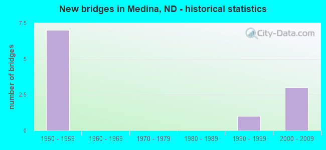
- New bridges - historical statistics
- 71950-1959
- 11990-1999
- 32000-2009

- Reconstructed bridges - Historical Statistics
- 11970-1979
- 11980-1989


- Bridge Condition - Deck
- 20.0%Very good
- 20.0%Good
- 40.0%Satisfactory
- 20.0%Fair

- Bridge Condition - Superstructure
- 40.0%Good
- 40.0%Satisfactory
- 20.0%Fair

- Bridge Condition - Substructure
- 20.0%Very good
- 20.0%Good
- 40.0%Satisfactory
- 20.0%Serious
Find on map >> Show street view
Structure Number: 4710531, Location: 3 WEST MEDINA (Lat: 46.886836, Lng: -99.370861), Route carried "on" structure: County highway , Year Built: 1995, Status: Open, Structure Length: 6.58m (21.59ft), Average Daily Traffic: 120 (year 2018), Truck Traffic: 13%, Average Future Daily Traffic: 120 (year 2038), Design Load: HS 25 or greater, Features Intersected: BURLINGTON NORTHERN RR, Facility Carried by Structure: COUNTY HIGHWAY
Minimum Vertical Clearance: 30+ m (98+ ft), Kilometerpoint: 0.000, Lanes on structure: 2, Owner: County Highway Agency, Approaching Roadway Width: 7.9m (25.9ft), Skew: 4 degrees, Material/Design: Prestressed concrete continuous, Design/Construction: Box Beam or Girders - Single/Spread, Number Of Spans In Main Unit: 3, Length of Maximum Span: 26.5m (86.9ft), Curb-To-Curb Width: 8.5m (27.9ft), Out-to-Out Width: 9.3m (30.5ft)
Condition: Deck: Good, Superstructure: Good, Substructure: Good, Operating Rating: 70.3 metric tons, Method Used To Determine Operating Rating: Load Factor (LF), Inventory Rating: 32.5 metric tons, Method Used To Determine Inventory Rating: Load Factor (LF), Structural Evaluation: Better than present minimum criteria, Deck Geometry: Equal to present minimum criteria, Underclear: Meets minimum limits, Approach Roadway Alignment: Equal to present desirable criteria, Designated Inspection Frequency: Every 24 months, Inspection Date: October 2021, Deck Structure Type: Concrete Cast-file-Place, Wearing Surface/Protective System: Wearing Surface: Monolithic Concrete, Deck Protection: Epoxy Coated Reinforcing
Find on map >> Show street view
Structure Number: 94228321, Location: JCT. ND 30 (Lat: 46.878333, Lng: -99.341667), Route carried "on" structure: State highway 30, Year Built: 1958, Status: Open, Structure Length: 6.46m (21.19ft), Average Daily Traffic: 400 (year 2020), Truck Traffic: 15%, Average Future Daily Traffic: 389 (year 2040), Design Load: HS 20, Features Intersected: I 94/STREETER INTERCHG
Minimum Vertical Clearance: 30+ m (98+ ft), Kilometerpoint: 68.263, Lanes on structure: 2, Lanes under structure: 4, Base Highway Network: Yes, Owner: State Highway Agency, Approaching Roadway Width: 8.5m (27.9ft), Material/Design: Prestressed concrete, Design/Construction: Stringer/Multi-beam, Number Of Spans In Main Unit: 4, Length of Maximum Span: 18.0m (59.1ft), Curb-To-Curb Width: 9.1m (29.9ft), Out-to-Out Width: 11.1m (36.4ft)
Condition: Deck: Fair, Superstructure: Fair, Substructure: Serious, Operating Rating: 83.0 metric tons, Method Used To Determine Operating Rating: Load Factor (LF), Inventory Rating: 43.8 metric tons, Method Used To Determine Inventory Rating: Load Factor (LF), Structural Evaluation: High priority of corrective action, Deck Geometry: Equal to present minimum criteria, Underclear: Meets minimum limits, Approach Roadway Alignment: Better than present minimum criteria, Designated Inspection Frequency: Every 12 months, Inspection Date: November 2021, Deck Structure Type: Concrete Cast-file-Place, Wearing Surface/Protective System: Wearing Surface: Monolithic Concrete
Find on map >> Show street view
Structure Number: 94230288, Location: 2 EAST OF ND 30 (Lat: 46.878333, Lng: -99.300000), Route carried "on" structure: County highway 4707, Year Built: 2009, Status: Open, Structure Length: 8.05m (26.41ft), Average Daily Traffic: 500 (year 2020), Truck Traffic: 14%, Average Future Daily Traffic: 825 (year 2040), Design Load: HS 25 or greater, Features Intersected: I94/MEDINA INTERCHANGE, Facility Carried by Structure: COUNTY HIGHWAY
Minimum Vertical Clearance: 30+ m (98+ ft), Kilometerpoint: 111.021, Lanes on structure: 2, Lanes under structure: 4, Owner: State Highway Agency, Approaching Roadway Width: 11.0m (36.1ft), Material/Design: Prestressed concrete continuous, Design/Construction: Stringer/Multi-beam, Number Of Spans In Main Unit: 2, Length of Maximum Span: 40.2m (131.9ft), Curb-To-Curb Width: 11.0m (36.1ft), Out-to-Out Width: 11.8m (38.7ft)
Condition: Deck: Very good, Superstructure: Good, Substructure: Very good, Operating Rating: 89.8 metric tons, Method Used To Determine Operating Rating: Load Factor (LF), Inventory Rating: 47.4 metric tons, Method Used To Determine Inventory Rating: Load Factor (LF), Structural Evaluation: Better than present minimum criteria, Deck Geometry: Better than present minimum criteria, Underclear: Equal to present minimum criteria, Approach Roadway Alignment: Equal to present minimum criteria, Designated Inspection Frequency: Every 24 months, Inspection Date: November 2020, Deck Structure Type: Concrete Cast-file-Place, Wearing Surface/Protective System: Wearing Surface: Monolithic Concrete, Deck Protection: Epoxy Coated Reinforcing
Find on map >> Show street view
Structure Number: 94233343 L, Location: 5 EAST OF ND 30 (Lat: 46.885000, Lng: -99.236667), Route carried "on" structure: Interstate 94, Year Built: 1958, Year Reconstructed: 1986, Status: Open, Structure Length: 3.51m (11.52ft), Average Daily Traffic: 3,300 (year 2020), Truck Traffic: 23%, Average Future Daily Traffic: 3,300 (year 2040), Design Load: HS 20, Features Intersected: HALFWAY LAKE INTERCHANGE
Minimum Vertical Clearance: 30+ m (98+ ft), Kilometerpoint: 375.449, Lanes on structure: 2, Lanes under structure: 2, Base Highway Network: Yes, Owner: State Highway Agency, Approaching Roadway Width: 11.6m (38.1ft), Skew: 10 degrees, Material/Design: Concrete continuous, Design/Construction: Tee Beam, Number Of Spans In Main Unit: 3, Length of Maximum Span: 13.1m (43.0ft), Curb-To-Curb Width: 12.2m (40.0ft), Out-to-Out Width: 13.1m (43.0ft)
Condition: Deck: Satisfactory, Superstructure: Satisfactory, Substructure: Satisfactory, Operating Rating: 59.6 metric tons, Method Used To Determine Operating Rating: Load Factor (LF), Inventory Rating: 35.7 metric tons, Method Used To Determine Inventory Rating: Load Factor (LF), Structural Evaluation: Equal to present minimum criteria, Deck Geometry: Better than present minimum criteria, Underclear: High priority of corrective action, Approach Roadway Alignment: Equal to present desirable criteria, Designated Inspection Frequency: Every 24 months, Inspection Date: November 2020, Deck Structure Type: Concrete Cast-file-Place, Wearing Surface/Protective System: Wearing Surface: Low Slump Concrete
Find on map >> Show street view
Structure Number: 94233343 R, Location: 5 EAST OF ND 30 (Lat: 46.885000, Lng: -99.236667), Route carried "on" structure: Interstate 94, Year Built: 1958, Year Reconstructed: 1984, Status: Open, Structure Length: 3.51m (11.52ft), Average Daily Traffic: 3,300 (year 2020), Truck Traffic: 23%, Average Future Daily Traffic: 3,300 (year 2040), Design Load: HS 20, Features Intersected: HALFWAY LAKE INTERCHANGE
Minimum Vertical Clearance: 30+ m (98+ ft), Kilometerpoint: 375.449, Lanes on structure: 2, Lanes under structure: 2, Base Highway Network: Yes, Owner: State Highway Agency, Approaching Roadway Width: 11.6m (38.1ft), Skew: 10 degrees, Material/Design: Concrete continuous, Design/Construction: Tee Beam, Number Of Spans In Main Unit: 3, Length of Maximum Span: 13.1m (43.0ft), Curb-To-Curb Width: 12.2m (40.0ft), Out-to-Out Width: 13.1m (43.0ft)
Condition: Deck: Satisfactory, Superstructure: Satisfactory, Substructure: Satisfactory, Operating Rating: 59.6 metric tons, Method Used To Determine Operating Rating: Load Factor (LF), Inventory Rating: 35.7 metric tons, Method Used To Determine Inventory Rating: Load Factor (LF), Structural Evaluation: Equal to present minimum criteria, Deck Geometry: Better than present minimum criteria, Underclear: High priority of corrective action, Approach Roadway Alignment: Equal to present desirable criteria, Designated Inspection Frequency: Every 24 months, Inspection Date: November 2020, Deck Structure Type: Concrete Cast-file-Place, Wearing Surface/Protective System: Wearing Surface: Low Slump Concrete
Find on map >> Show street view
Structure Number: 94228321, Location: JCT. ND 30 (Lat: 46.878333, Lng: -99.341667), Route carried "under" structure: Interstate 94, Year Built: 1958, Structure Length: 0. m, Average Daily Traffic: 6,400 (year 2011), Truck Traffic: 23%, Features Intersected: I 94/STREETER INTERCHG, Facility Carried by Structure: ND HIGHWAY 30
Minimum Vertical Clearance: 5.06m (16.60ft), Kilometerpoint: 367.447, Lanes on structure: 2, Lanes under structure: 2, Material/Design: Prestressed concrete, Design/Construction: Stringer/Multi-beam, Length of Maximum Span: 18.0m (59.1ft)
Find on map >> Show street view
Structure Number: 94228321, Location: JCT. ND 30 (Lat: 46.878333, Lng: -99.341667), Route carried "under" structure: Interstate 94, Year Built: 1958, Structure Length: 0. m, Average Daily Traffic: 6,400 (year 2011), Truck Traffic: 23%, Features Intersected: I 94/STREETER INTERCHG, Facility Carried by Structure: ND HIGHWAY 30
Minimum Vertical Clearance: 4.94m (16.21ft), Kilometerpoint: 367.447, Lanes on structure: 2, Lanes under structure: 2, Material/Design: Prestressed concrete, Design/Construction: Stringer/Multi-beam, Length of Maximum Span: 18.0m (59.1ft)
Find on map >> Show street view
Structure Number: 94230288, Location: 2 EAST OF ND 30 (Lat: 46.878333, Lng: -99.300000), Route carried "under" structure: Interstate 94, Year Built: 2009, Structure Length: 0. m, Average Daily Traffic: 6,500 (year 2010), Truck Traffic: 24%, Features Intersected: I94/MEDINA INTERCHANGE, Facility Carried by Structure: COUNTY HIGHWAY
Minimum Vertical Clearance: 4.99m (16.37ft), Kilometerpoint: 370.613, Lanes on structure: 2, Lanes under structure: 2, Material/Design: Prestressed concrete continuous, Design/Construction: Stringer/Multi-beam, Length of Maximum Span: 40.2m (131.9ft)
Find on map >> Show street view
Structure Number: 94230288, Location: 2 EAST OF ND 30 (Lat: 46.878333, Lng: -99.300000), Route carried "under" structure: Interstate 94, Year Built: 2009, Structure Length: 0. m, Average Daily Traffic: 500 (year 2010), Truck Traffic: 5%, Features Intersected: I94/MEDINA INTERCHANGE, Facility Carried by Structure: COUNTY HIGHWAY
Minimum Vertical Clearance: 5.07m (16.63ft), Kilometerpoint: 370.613, Lanes on structure: 2, Lanes under structure: 2, Material/Design: Prestressed concrete continuous, Design/Construction: Stringer/Multi-beam, Length of Maximum Span: 40.2m (131.9ft)
Find on map >> Show street view
Structure Number: 94233343 L, Location: 5 EAST OF ND 30 (Lat: 46.885000, Lng: -99.236667), Route carried "under" structure: County highway , Year Built: 1958, Structure Length: 0. m, Average Daily Traffic: 3,300 (year 2011), Truck Traffic: 23%, Features Intersected: HALFWAY LAKE INTERCHANGE, Facility Carried by Structure: INTERSTATE 94
Minimum Vertical Clearance: 4.57m (14.99ft), Kilometerpoint: 0.000, Lanes on structure: 2, Lanes under structure: 2, Material/Design: Concrete continuous, Design/Construction: Tee Beam, Length of Maximum Span: 13.1m (43.0ft)
Find on map >> Show street view
Structure Number: 94233343 R, Location: 5 EAST OF ND 30 (Lat: 46.885000, Lng: -99.236667), Route carried "under" structure: County highway , Year Built: 1958, Structure Length: 0. m, Average Daily Traffic: 3,300 (year 2011), Truck Traffic: 23%, Features Intersected: HALFWAY LAKE INTERCHANGE, Facility Carried by Structure: INTERSTATE 94
Minimum Vertical Clearance: 4.28m (14.04ft), Kilometerpoint: 0.000, Lanes on structure: 2, Lanes under structure: 2, Material/Design: Concrete continuous, Design/Construction: Tee Beam, Length of Maximum Span: 13.1m (43.0ft)