Bridge Statistics for Mehlville, Missouri (MO)
Condition, Traffic, Stress, Structural Evaluation, Project Costs
- National Bridge Inventory (NBI) Statistics
- 15Number of bridges
- 515ft / 157mTotal length
- $2,819,000Total costs
- 345,654Total average daily traffic
- 39,288Total average daily truck traffic
- National Bridge Inventory (NBI) Registered Bridges for Mehlville
- No street view available for this location
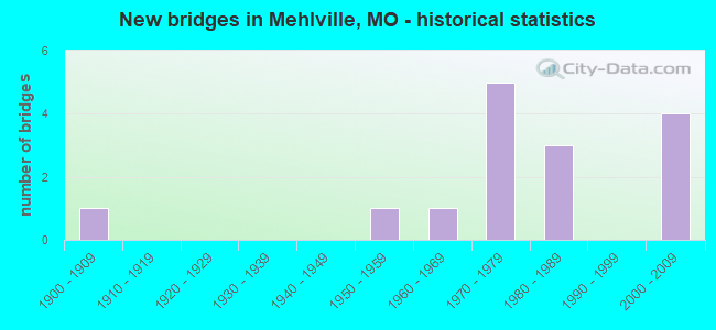
- New bridges - historical statistics
- 11900-1909
- 11950-1959
- 11960-1969
- 51970-1979
- 31980-1989
- 42000-2009
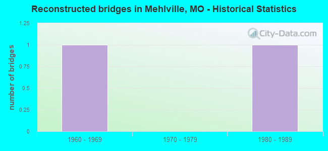
- Reconstructed bridges - Historical Statistics
- 11960-1969
- 01970-1979
- 11980-1989
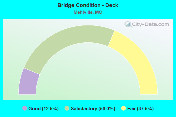
- Bridge Condition - Deck
- 12.5%Good
- 50.0%Satisfactory
- 37.5%Fair
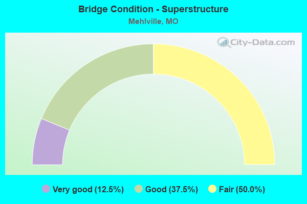
- Bridge Condition - Superstructure
- 12.5%Very good
- 37.5%Good
- 50.0%Fair
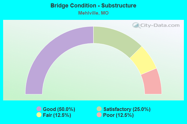
- Bridge Condition - Substructure
- 50.0%Good
- 25.0%Satisfactory
- 12.5%Fair
- 12.5%Poor
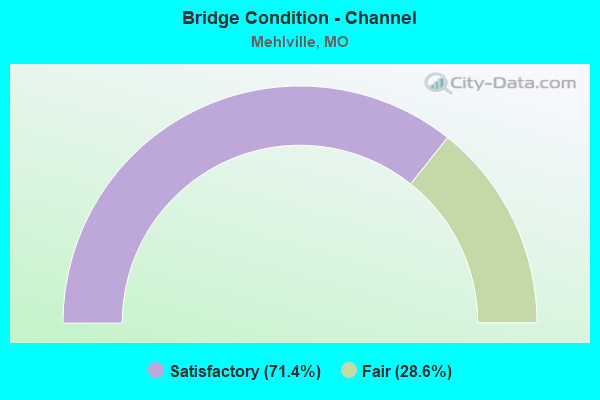
- Bridge Condition - Channel
- 71.4%Satisfactory
- 28.6%Fair
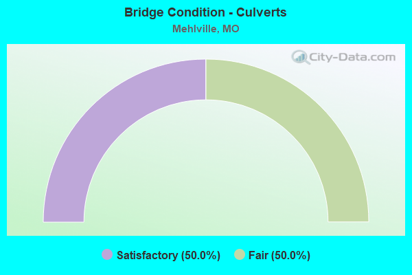
- Bridge Condition - Culverts
- 50.0%Satisfactory
- 50.0%Fair
Find on map >> Show street view
Structure Number: 1541, Location: S 6 T 43 N R 7 E (Lat: 38.487339, Lng: -90.276950), Route carried "on" structure: Interstate 255, Year Built: 1985, Status: Open, Structure Length: 122.03m (400.36ft), Average Daily Traffic: 28,441 (year 2021), Truck Traffic: 18%, Average Future Daily Traffic: 35,551 (year 2041), Design Load: HS 20, Features Intersected: MISSISSIPPI RVR, UP RR
Minimum Vertical Clearance: 6.10m (20.01ft), Kilometerpoint: 0.000, Lanes on structure: 3, Base Highway Network: Yes, Owner: State Highway Agency, Approaching Roadway Width: 15.5m (50.9ft), Navigation Control: Yes ( Vertical Clearance: 18.6m (61.0ft), Horizontal Clearance: 259.1m (850.1ft)), Material/Design: Steel, Design/Construction: Arch - Thru, Number Of Spans In Main Unit: 1, Number Of Approach Spans: 14, Length of Maximum Span: 277.4m (910.1ft), Curb-To-Curb Width: 15.5m (50.9ft), Out-to-Out Width: 16.5m (54.1ft)
Condition: Deck: Satisfactory, Superstructure: Fair, Substructure: Fair, Channel: Satisfactory, Operating Rating: 63.0 metric tons, Method Used To Determine Operating Rating: Load Factor (LF), Inventory Rating: 37.8 metric tons, Method Used To Determine Inventory Rating: Load Factor (LF), Structural Evaluation: Somewhat better than minimum adequacy, Deck Geometry: Somewhat better than minimum adequacy, Underclear: Superior to present desirable criteria, Waterway Adequacy: Equal to present desirable criteria, Approach Roadway Alignment: Equal to present desirable criteria, Designated Inspection Frequency: Every 24 months, Critical Feature Inspection Frequency: Every 24 months, Underwater Inspection Frequency: Every 60 months, Other Special Inspection Frequency: Every 24 months, Inspection Date: May 2021, Critical Feature Inspection Date: May 2021, Underwater Inspection Date: October 2019, Other Special Inspection Date: May 2021, Deck Structure Type: Concrete Cast-file-Place, Wearing Surface/Protective System: Wearing Surface: Other, Deck Protection: Epoxy Coated Reinforcing
Find on map >> Show street view
Structure Number: 1563, Location: S 26 T 44 N R 6 E (Lat: 38.522081, Lng: -90.320103), Route carried "on" structure: County highway , Year Built: 1967, Year Reconstructed: 1993, Status: Posted for load, Structure Length: 4.79m (15.72ft), Average Daily Traffic: 11,550 (year 2020), Truck Traffic: 5%, Average Future Daily Traffic: 15,593 (year 2040), Design Load: HS 20, Features Intersected: GRAVOIS CR, Facility Carried by Structure: UNION RD
Minimum Vertical Clearance: 30+ m (98+ ft), Kilometerpoint: 0.966, Lanes on structure: 4, Owner: County Highway Agency, Approaching Roadway Width: 14.6m (47.9ft), Skew: 2 degrees, Material/Design: Steel continuous, Design/Construction: Stringer/Multi-beam, Number Of Spans In Main Unit: 2, Length of Maximum Span: 22.9m (75.1ft), Curb or Sidewalk Widths: Left: 1.4m (4.6ft), Right: 1.4m (4.6ft), Curb-To-Curb Width: 14.6m (47.9ft), Out-to-Out Width: 18.2m (59.7ft)
Condition: Deck: Satisfactory, Superstructure: Good, Substructure: Satisfactory, Channel: Satisfactory, Operating Rating: 42.3 metric tons, Method Used To Determine Operating Rating: Allowable Stress (AS), Inventory Rating: 25.2 metric tons, Method Used To Determine Inventory Rating: Allowable Stress (AS), Structural Evaluation: Equal to present minimum criteria, Deck Geometry: High priority of replacement, Waterway Adequacy: Superior to present desirable criteria, Approach Roadway Alignment: Equal to present desirable criteria, Length Of Structure Improvement: 0.58m (1.90ft), Designated Inspection Frequency: Every 24 months, Inspection Date: Febuary 2020, Bridge Improvement Cost: $775,000, Roadway Improvement Cost: $78,000, Total Project Cost: $1,163,000 ( Estimate for 2022), Deck Structure Type: Concrete Cast-file-Place, Wearing Surface/Protective System: Wearing Surface: Monolithic Concrete, Membrane: Epoxy
Find on map >> Show street view
Structure Number: 15631, Location: S 25 T 44 N R 6 E (Lat: 38.526422, Lng: -90.300161), Route carried "on" structure: County highway , Year Built: 1959, Year Reconstructed: 1971, Status: Posted for load, Structure Length: 4.60m (15.09ft), Average Daily Traffic: 15,054 (year 2020), Truck Traffic: 4%, Average Future Daily Traffic: 20,323 (year 2040), Design Load: HS 20, Features Intersected: GRAVOIS CR, Facility Carried by Structure: REAVIS BARRACKS RD
Minimum Vertical Clearance: 30+ m (98+ ft), Kilometerpoint: 0.000, Lanes on structure: 4, Owner: County Highway Agency, Approaching Roadway Width: 14.0m (45.9ft), Material/Design: Concrete continuous, Design/Construction: Slab, Number Of Spans In Main Unit: 3, Length of Maximum Span: 17.7m (58.1ft), Curb or Sidewalk Widths: Left: 1.2m (3.9ft), Right: 1.2m (3.9ft), Curb-To-Curb Width: 14.1m (46.3ft), Out-to-Out Width: 16.5m (54.1ft)
Condition: Deck: Fair, Superstructure: Fair, Substructure: Poor, Channel: Fair, Operating Rating: 63.0 metric tons, Method Used To Determine Operating Rating: Allowable Stress (AS), Inventory Rating: 43.2 metric tons, Method Used To Determine Inventory Rating: Allowable Stress (AS), Structural Evaluation: Meets minimum limits, Deck Geometry: High priority of replacement, Waterway Adequacy: Somewhat better than minimum adequacy, Approach Roadway Alignment: Better than present minimum criteria, Length Of Structure Improvement: 0.56m (1.84ft), Designated Inspection Frequency: Every 24 months, Inspection Date: Febuary 2020, Bridge Improvement Cost: $1,104,000, Roadway Improvement Cost: $110,000, Total Project Cost: $1,656,000 ( Estimate for 2022), Deck Structure Type: Concrete Cast-file-Place, Wearing Surface/Protective System: Wearing Surface: Bituminous
Find on map >> Show street view
Structure Number: 15654, Location: S 4 T 43 N R 6 E (Lat: 38.494572, Lng: -90.345119), Route carried "on" structure: County highway , Year Built: 1987, Status: Posted for load, Structure Length: 1.71m (5.61ft), Average Daily Traffic: 10,357 (year 2020), Truck Traffic: 10%, Average Future Daily Traffic: 13,982 (year 2040), Design Load: HS 20+Mod, Features Intersected: W TRIB MATTESE CR, Facility Carried by Structure: MATTIS RD
Minimum Vertical Clearance: 30+ m (98+ ft), Kilometerpoint: 4.023, Lanes on structure: 2, Owner: County Highway Agency, Approaching Roadway Width: 13.4m (44.0ft), Material/Design: Prestressed concrete, Design/Construction: Stringer/Multi-beam, Number Of Spans In Main Unit: 1, Length of Maximum Span: 16.2m (53.1ft), Curb or Sidewalk Widths: Left: 1.7m (5.6ft), Right: 1.7m (5.6ft), Curb-To-Curb Width: 13.4m (44.0ft), Out-to-Out Width: 17.9m (58.7ft)
Condition: Deck: Satisfactory, Superstructure: Good, Substructure: Good, Channel: Satisfactory, Operating Rating: 30.6 metric tons, Method Used To Determine Operating Rating: Allowable Stress (AS), Inventory Rating: 22.5 metric tons, Method Used To Determine Inventory Rating: Allowable Stress (AS), Structural Evaluation: Somewhat better than minimum adequacy, Deck Geometry: Equal to present minimum criteria, Waterway Adequacy: Superior to present desirable criteria, Approach Roadway Alignment: Equal to present desirable criteria, Designated Inspection Frequency: Every 24 months, Inspection Date: March 2020, Deck Structure Type: Concrete Cast-file-Place, Wearing Surface/Protective System: Wearing Surface: Monolithic Concrete, Membrane: Epoxy, Deck Protection: Epoxy Coated Reinforcing
Find on map >> Show street view
Structure Number: 2239, Location: S 3119 T 43 N R 7 E (Lat: 38.489136, Lng: -90.284344), Route carried "on" structure: Interstate 255, Year Built: 1977, Status: Open, Structure Length: 5.79m (19.00ft), Average Daily Traffic: 30,176 (year 2021), Truck Traffic: 18%, Average Future Daily Traffic: 37,720 (year 2041), Design Load: HS 20+Mod, Features Intersected: CRD KOCH RD
Minimum Vertical Clearance: 30+ m (98+ ft), Kilometerpoint: 5.469, Lanes on structure: 4, Lanes under structure: 4, Base Highway Network: Yes, Owner: State Highway Agency, Approaching Roadway Width: 18.3m (60.0ft), Skew: 12 degrees, Material/Design: Concrete continuous, Design/Construction: Slab, Number Of Spans In Main Unit: 4, Length of Maximum Span: 18.0m (59.1ft), Curb or Sidewalk Widths: Left: 0.2m (0.7ft), Right: 0.2m (0.7ft), Curb-To-Curb Width: 20.9m (68.6ft), Out-to-Out Width: 21.9m (71.9ft)
Condition: Deck: Fair, Superstructure: Fair, Substructure: Satisfactory, Operating Rating: 61.2 metric tons, Method Used To Determine Operating Rating: Load Factor (LF), Inventory Rating: 36.9 metric tons, Method Used To Determine Inventory Rating: Load Factor (LF), Structural Evaluation: Somewhat better than minimum adequacy, Deck Geometry: Better than present minimum criteria, Underclear: Equal to present minimum criteria, Approach Roadway Alignment: Equal to present desirable criteria, Designated Inspection Frequency: Every 24 months, Inspection Date: July 2020, Deck Structure Type: Concrete Cast-file-Place, Wearing Surface/Protective System: Wearing Surface: Latex Concrete
Find on map >> Show street view
Structure Number: 224, Location: S 3119 T 43 N R 7 E (Lat: 38.489339, Lng: -90.284392), Route carried "on" structure: Interstate 255, Year Built: 1977, Status: Open, Structure Length: 5.79m (19.00ft), Average Daily Traffic: 28,441 (year 2021), Truck Traffic: 18%, Average Future Daily Traffic: 35,551 (year 2041), Design Load: HS 20+Mod, Features Intersected: CRD KOCH RD
Minimum Vertical Clearance: 30+ m (98+ ft), Kilometerpoint: 0.890, Lanes on structure: 4, Lanes under structure: 4, Base Highway Network: Yes, Owner: State Highway Agency, Approaching Roadway Width: 18.3m (60.0ft), Skew: 12 degrees, Material/Design: Concrete continuous, Design/Construction: Slab, Number Of Spans In Main Unit: 4, Length of Maximum Span: 18.0m (59.1ft), Curb-To-Curb Width: 18.3m (60.0ft), Out-to-Out Width: 19.4m (63.6ft)
Condition: Deck: Fair, Superstructure: Fair, Substructure: Good, Operating Rating: 61.2 metric tons, Method Used To Determine Operating Rating: Load Factor (LF), Inventory Rating: 36.9 metric tons, Method Used To Determine Inventory Rating: Load Factor (LF), Structural Evaluation: Somewhat better than minimum adequacy, Deck Geometry: Meets minimum limits, Underclear: Equal to present minimum criteria, Approach Roadway Alignment: Equal to present desirable criteria, Designated Inspection Frequency: Every 24 months, Inspection Date: July 2020, Deck Structure Type: Concrete Cast-file-Place, Wearing Surface/Protective System: Wearing Surface: Latex Concrete
Find on map >> Show street view
Structure Number: 29644, Location: S 4 T 43 N R 6 E (Lat: 38.494736, Lng: -90.344189), Route carried "on" structure: US 61, Year Built: 2003, Status: Open, Structure Length: 3.57m (11.71ft), Average Daily Traffic: 29,007 (year 2021), Truck Traffic: 3%, Average Future Daily Traffic: 40,610 (year 2041), Design Load: HS 20+Mod, Features Intersected: MATTESE CR
Minimum Vertical Clearance: 30+ m (98+ ft), Kilometerpoint: 285.505, Lanes on structure: 6, Base Highway Network: Yes, Owner: State Highway Agency, Approaching Roadway Width: 28.3m (92.8ft), Material/Design: Prestressed concrete, Design/Construction: Stringer/Multi-beam, Number Of Spans In Main Unit: 1, Length of Maximum Span: 21.0m (68.9ft), Curb-To-Curb Width: 28.0m (91.9ft), Out-to-Out Width: 28.8m (94.5ft)
Condition: Deck: Good, Superstructure: Very good, Substructure: Good, Channel: Satisfactory, Operating Rating: 98.1 metric tons, Method Used To Determine Operating Rating: Load Factor (LF), Inventory Rating: 49.5 metric tons, Method Used To Determine Inventory Rating: Load Factor (LF), Structural Evaluation: Better than present minimum criteria, Deck Geometry: Superior to present desirable criteria, Waterway Adequacy: Superior to present desirable criteria, Approach Roadway Alignment: Equal to present desirable criteria, Designated Inspection Frequency: Every 24 months, Inspection Date: July 2020, Deck Structure Type: Concrete Cast-file-Place, Wearing Surface/Protective System: Wearing Surface: Monolithic Concrete, Deck Protection: Epoxy Coated Reinforcing
Find on map >> Show street view
Structure Number: 31869, Location: S 1 T 43 N R 6 E (Lat: 38.494814, Lng: -90.301992), Route carried "on" structure: State highway 231, Year Built: 2007, Status: Open, Structure Length: 7.32m (24.02ft), Average Daily Traffic: 46,256 (year 2021), Truck Traffic: 4%, Average Future Daily Traffic: 64,758 (year 2041), Features Intersected: IS 255
Minimum Vertical Clearance: 30+ m (98+ ft), Kilometerpoint: 5.821, Lanes on structure: 7, Lanes under structure: 8, Base Highway Network: Yes, Owner: State Highway Agency, Approaching Roadway Width: 28.7m (94.2ft), Material/Design: Steel continuous, Design/Construction: Stringer/Multi-beam, Number Of Spans In Main Unit: 2, Length of Maximum Span: 36.6m (120.1ft), Curb-To-Curb Width: 28.7m (94.2ft), Out-to-Out Width: 31.3m (102.7ft)
Condition: Deck: Satisfactory, Superstructure: Good, Substructure: Good, Operating Rating: 66.6 metric tons, Method Used To Determine Operating Rating: Load Factor (LF), Inventory Rating: 39.6 metric tons, Method Used To Determine Inventory Rating: Load Factor (LF), Structural Evaluation: Better than present minimum criteria, Deck Geometry: Somewhat better than minimum adequacy, Underclear: High priority of corrective action, Approach Roadway Alignment: Equal to present desirable criteria, Designated Inspection Frequency: Every 24 months, Inspection Date: July 2020, Deck Structure Type: Concrete Cast-file-Place, Wearing Surface/Protective System: Wearing Surface: Monolithic Concrete, Deck Protection: Epoxy Coated Reinforcing
Find on map >> Show street view
Structure Number: 3244, Location: S 3317 T 43 N R 6 E (Lat: 38.487122, Lng: -90.304172), Route carried "on" structure: State highway 231, Year Built: 1900, Status: Open, Structure Length: 0.91m (2.99ft), Average Daily Traffic: 44,574 (year 2021), Truck Traffic: 5%, Average Future Daily Traffic: 62,404 (year 2041), Design Load: HS 20, Features Intersected: MARTIGNEY CR
Minimum Vertical Clearance: 30+ m (98+ ft), Kilometerpoint: 6.729, Lanes on structure: 5, Base Highway Network: Yes, Owner: State Highway Agency, Approaching Roadway Width: 25.0m (82.0ft), Skew: 10 degrees, Material/Design: Concrete continuous, Design/Construction: Culvert, Number Of Spans In Main Unit: 3, Length of Maximum Span: 3.1m (10.2ft)
Condition: Channel: Fair, Culverts: Fair, Operating Rating: 24.3 metric tons, Method Used To Determine Operating Rating: Field evaluation and documented engineering judgment, Inventory Rating: 16.2 metric tons, Method Used To Determine Inventory Rating: Field evaluation and documented engineering judgment, Structural Evaluation: Meets minimum limits, Waterway Adequacy: Equal to present desirable criteria, Approach Roadway Alignment: Equal to present desirable criteria, Designated Inspection Frequency: Every 24 months, Inspection Date: November 2021
Find on map >> Show street view
Structure Number: 3702, Location: S 413 T 47 N R 1 E (Lat: 38.853417, Lng: -90.867544), Route carried "on" structure: State highway P, Year Built: 1987, Status: Open, Structure Length: 0.97m (3.18ft), Average Daily Traffic: 4,745 (year 2021), Truck Traffic: 3%, Average Future Daily Traffic: 9,253 (year 2041), Design Load: HS 20, Features Intersected: BR OF MCCOY CR
Minimum Vertical Clearance: 30+ m (98+ ft), Kilometerpoint: 0.143, Lanes on structure: 2, Owner: State Highway Agency, Approaching Roadway Width: 10.4m (34.1ft), Skew: 1 degrees, Material/Design: Concrete, Design/Construction: Culvert, Number Of Spans In Main Unit: 3, Length of Maximum Span: 3.0m (9.8ft), Curb-To-Curb Width: 11.6m (38.1ft), Out-to-Out Width: 12.2m (40.0ft)
Condition: Channel: Satisfactory, Culverts: Satisfactory, Operating Rating: 89.1 metric tons, Method Used To Determine Operating Rating: Load Factor (LF), Inventory Rating: 53.1 metric tons, Method Used To Determine Inventory Rating: Load Factor (LF), Structural Evaluation: Equal to present minimum criteria, Deck Geometry: Somewhat better than minimum adequacy, Waterway Adequacy: Equal to present desirable criteria, Approach Roadway Alignment: Equal to present minimum criteria, Designated Inspection Frequency: Every 24 months, Inspection Date: November 2021
Find on map >> Show street view
Structure Number: 2239, Location: S 3119 T 43 N R 7 E (Lat: 38.489136, Lng: -90.284344), Route carried "under" structure: County highway , Year Built: 1977, Structure Length: 0. m, Average Daily Traffic: 4,433 (year 2021), Truck Traffic: 5%, Features Intersected: CRD KOCH RD, Facility Carried by Structure: IS 255 S
Minimum Vertical Clearance: 4.47m (14.67ft), Kilometerpoint: 1.091, Lanes on structure: 4, Lanes under structure: 4, Material/Design: Concrete continuous, Design/Construction: Slab, Length of Maximum Span: 18.0m (59.1ft)
Find on map >> Show street view
Structure Number: 224, Location: S 3119 T 43 N R 7 E (Lat: 38.489339, Lng: -90.284392), Route carried "under" structure: County highway , Year Built: 1977, Structure Length: 0. m, Average Daily Traffic: 2,682 (year 2021), Truck Traffic: 5%, Features Intersected: CRD KOCH RD, Facility Carried by Structure: IS 255 N
Minimum Vertical Clearance: 4.47m (14.67ft), Kilometerpoint: 1.091, Lanes on structure: 4, Lanes under structure: 2, Material/Design: Concrete continuous, Design/Construction: Slab, Length of Maximum Span: 18.0m (59.1ft)
Find on map >> Show street view
Structure Number: 224, Location: S 3119 T 43 N R 7 E (Lat: 38.489339, Lng: -90.284392), Route carried "under" structure: County highway , Year Built: 1977, Structure Length: 0. m, Average Daily Traffic: 1,751 (year 2021), Truck Traffic: 5%, Features Intersected: CRD KOCH RD, Facility Carried by Structure: IS 255 N
Minimum Vertical Clearance: 4.47m (14.67ft), Kilometerpoint: 0.650, Lanes on structure: 4, Lanes under structure: 2, Material/Design: Concrete continuous, Design/Construction: Slab, Length of Maximum Span: 18.0m (59.1ft)
Find on map >> Show street view
Structure Number: 31869, Location: S 1 T 43 N R 6 E (Lat: 38.494814, Lng: -90.301992), Route carried "under" structure: Interstate 255, Year Built: 2007, Structure Length: 0. m, Average Daily Traffic: 43,818 (year 2021), Truck Traffic: 18%, Features Intersected: IS 255, Facility Carried by Structure: MO 231 S
Minimum Vertical Clearance: 4.95m (16.24ft), Kilometerpoint: 2.565, Lanes on structure: 7, Lanes under structure: 5, Material/Design: Steel continuous, Design/Construction: Stringer/Multi-beam, Length of Maximum Span: 36.6m (120.1ft)
Find on map >> Show street view
Structure Number: 31869, Location: S 1 T 43 N R 6 E (Lat: 38.494814, Lng: -90.301992), Route carried "under" structure: Interstate 255, Year Built: 2007, Structure Length: 0. m, Average Daily Traffic: 44,369 (year 2021), Truck Traffic: 18%, Features Intersected: IS 255, Facility Carried by Structure: MO 231 S
Minimum Vertical Clearance: 5.16m (16.93ft), Kilometerpoint: 3.833, Lanes on structure: 7, Lanes under structure: 3, Material/Design: Steel continuous, Design/Construction: Stringer/Multi-beam, Length of Maximum Span: 36.6m (120.1ft)