Bridge Statistics for Melrose Park, Illinois (IL)
Condition, Traffic, Stress, Structural Evaluation, Project Costs
- National Bridge Inventory (NBI) Statistics
- 14Number of bridges
- 299ft / 90.9mTotal length
- $25,947,000Total costs
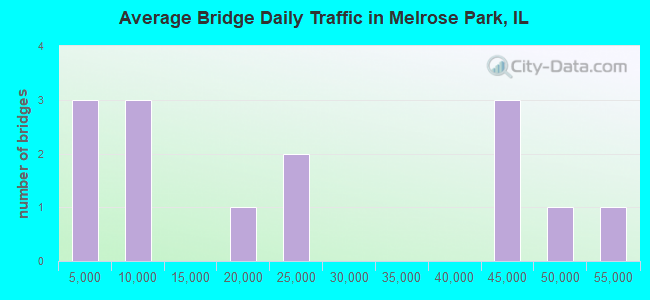
- 317,000Total average daily traffic
- 21,686Total average daily truck traffic
- National Bridge Inventory (NBI) Registered Bridges for Melrose Park
- No street view available for this location
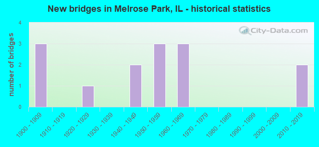
- New bridges - historical statistics
- 31900-1909
- 11920-1929
- 21940-1949
- 31950-1959
- 31960-1969
- 22010-2019
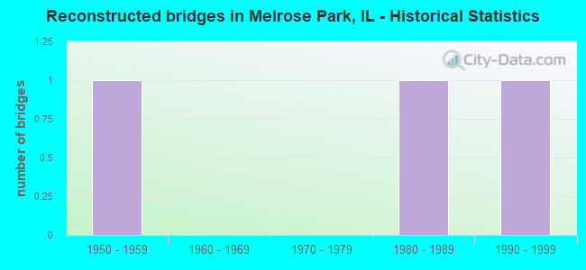
- Reconstructed bridges - Historical Statistics
- 11950-1959
- 01960-1969
- 01970-1979
- 11980-1989
- 11990-1999
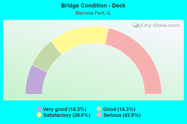
- Bridge Condition - Deck
- 14.3%Very good
- 14.3%Good
- 28.6%Satisfactory
- 42.9%Serious
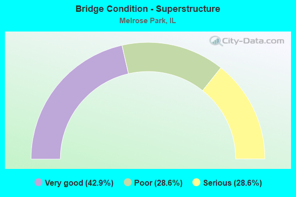
- Bridge Condition - Superstructure
- 42.9%Very good
- 28.6%Poor
- 28.6%Serious
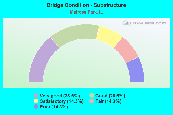
- Bridge Condition - Substructure
- 28.6%Very good
- 28.6%Good
- 14.3%Satisfactory
- 14.3%Fair
- 14.3%Poor
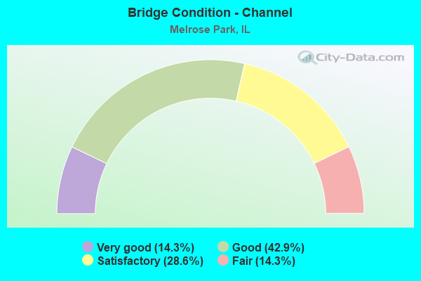
- Bridge Condition - Channel
- 14.3%Very good
- 42.9%Good
- 28.6%Satisfactory
- 14.3%Fair
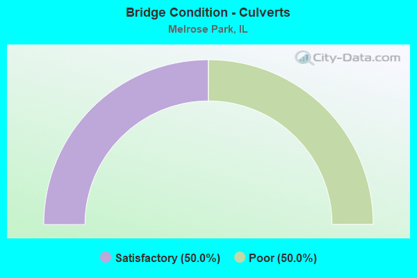
- Bridge Condition - Culverts
- 50.0%Satisfactory
- 50.0%Poor
Find on map >> Show street view
Structure Number: 160337, Location: 0.3 M S US 20 (Lat: 41.895089, Lng: -87.883608), Route carried "on" structure: US 12, Year Built: 1954, Year Reconstructed: 1998, Status: Open, Structure Length: 42.92m (140.81ft), Average Daily Traffic: 43,000 (year 2021), Truck Traffic: 11%, Average Future Daily Traffic: 37,389 (year 2032), Features Intersected: RR - UP PROVISO YD
Minimum Vertical Clearance: 30+ m (98+ ft), Kilometerpoint: 86.516, Lanes on structure: 4, Base Highway Network: Yes, Owner: State Highway Agency, Approaching Roadway Width: 16.5m (54.1ft), Skew: 30 degrees, Material/Design: Steel continuous, Design/Construction: Stringer/Multi-beam, Number Of Spans In Main Unit: 18, Length of Maximum Span: 36.6m (120.1ft), Curb or Sidewalk Widths: Left: 1.8m (5.9ft), Right: 1.8m (5.9ft), Curb-To-Curb Width: 16.5m (54.1ft), Out-to-Out Width: 21.9m (71.9ft)
Condition: Deck: Satisfactory, Superstructure: Very good, Substructure: Satisfactory, Operating Rating: 66.4 metric tons, Method Used To Determine Operating Rating: Load Factor (LF) rating reported by rating factor (RF) method using MS18 loading, Inventory Rating: 39.9 metric tons, Method Used To Determine Inventory Rating: Load Factor (LF) rating reported by rating factor (RF) method using MS18 loading, Structural Evaluation: Equal to present minimum criteria, Deck Geometry: Meets minimum limits, Underclear: Meets minimum limits, Approach Roadway Alignment: Better than present minimum criteria, Length Of Structure Improvement: 42.92m (140.81ft), Designated Inspection Frequency: Every 24 months, Inspection Date: August 2020, Bridge Improvement Cost: $5,745,000, Roadway Improvement Cost: $575,000, Total Project Cost: $8,617,000, Deck Structure Type: Concrete Cast-file-Place, Wearing Surface/Protective System: Deck Protection: Epoxy Coated Reinforcing
Find on map >> Show street view
Structure Number: 161011, Location: 0.3 M N IL 64 (Lat: 41.914036, Lng: -87.864594), Route carried "on" structure: Other road , Year Built: 1965, Year Reconstructed: 1994, Status: Temporarily open, Structure Length: 39.83m (130.68ft), Average Daily Traffic: 17,900 (year 2018), Truck Traffic: 8%, Average Future Daily Traffic: 18,231 (year 2032), Design Load: HS 20, Features Intersected: RR - IHB, Facility Carried by Structure: 25TH AVE
Minimum Vertical Clearance: 30+ m (98+ ft), Kilometerpoint: 6.019, Lanes on structure: 4, Base Highway Network: Yes, Owner: State Highway Agency, Approaching Roadway Width: 15.2m (49.9ft), Skew: 34 degrees, Material/Design: Steel continuous, Design/Construction: Stringer/Multi-beam, Number Of Spans In Main Unit: 16, Length of Maximum Span: 30.6m (100.4ft), Curb or Sidewalk Widths: Left: 1.5m (4.9ft), Right: 1.5m (4.9ft), Curb-To-Curb Width: 15.2m (49.9ft), Out-to-Out Width: 18.9m (62.0ft)
Condition: Deck: Satisfactory, Superstructure: Poor, Substructure: Fair, Operating Rating: 76.8 metric tons, Method Used To Determine Operating Rating: Load Factor (LF) rating reported by rating factor (RF) method using MS18 loading, Inventory Rating: 46.0 metric tons, Method Used To Determine Inventory Rating: Load Factor (LF) rating reported by rating factor (RF) method using MS18 loading, Structural Evaluation: Meets minimum limits, Deck Geometry: High priority of corrective action, Underclear: Equal to present minimum criteria, Approach Roadway Alignment: Equal to present minimum criteria, Length Of Structure Improvement: 41.12m (134.91ft), Designated Inspection Frequency: Every 12 months, Other Special Inspection Frequency: Every 6 months, Inspection Date: July 2021, Other Special Inspection Date: July 2021, Bridge Improvement Cost: $11,254,000, Roadway Improvement Cost: $1,125,000, Total Project Cost: $16,881,000, Deck Structure Type: Concrete Cast-file-Place, Wearing Surface/Protective System: Deck Protection: Epoxy Coated Reinforcing
Find on map >> Show street view
Structure Number: 161259, Location: BETWEEN 20TH & 21ST (Lat: 41.907875, Lng: -87.858650), Route carried "on" structure: State highway 64, Year Built: 1927, Year Reconstructed: 1955, Status: Open, Structure Length: 1.01m (3.31ft), Average Daily Traffic: 50,800 (year 2021), Truck Traffic: 7%, Average Future Daily Traffic: 82,800 (year 2035), Features Intersected: DITCH
Minimum Vertical Clearance: 30+ m (98+ ft), Kilometerpoint: 203.496, Lanes on structure: 5, Base Highway Network: Yes, Owner: State Highway Agency, Approaching Roadway Width: 27.1m (88.9ft), Material/Design: Concrete continuous, Design/Construction: Culvert, Number Of Spans In Main Unit: 3, Length of Maximum Span: 3.4m (11.2ft)
Condition: Channel: Fair, Culverts: Satisfactory, Operating Rating: 54.1 metric tons, Method Used To Determine Operating Rating: Field evaluation and documented engineering judgment, Inventory Rating: 32.4 metric tons, Method Used To Determine Inventory Rating: Field evaluation and documented engineering judgment, Structural Evaluation: Equal to present minimum criteria, Waterway Adequacy: Equal to present minimum criteria, Approach Roadway Alignment: Equal to present desirable criteria, Designated Inspection Frequency: Every 24 months, Inspection Date: October 2021
Find on map >> Show street view
Structure Number: 162818, Location: 0.6 M S IL 64 (Lat: 41.899764, Lng: -87.839681), Route carried "on" structure: Other road , Year Built: 2012, Status: Open, Structure Length: 1.42m (4.66ft), Average Daily Traffic: 8,750 (year 2021), Truck Traffic: 4%, Average Future Daily Traffic: 8,200 (year 2036), Features Intersected: SILVER CREEK, Facility Carried by Structure: 5TH AVE
Minimum Vertical Clearance: 30+ m (98+ ft), Kilometerpoint: 2.543, Lanes on structure: 4, Owner: State Highway Agency, Approaching Roadway Width: 13.4m (44.0ft), Material/Design: Concrete, Design/Construction: Slab, Number Of Spans In Main Unit: 1, Length of Maximum Span: 12.0m (39.4ft), Curb or Sidewalk Widths: Left: 2.0m (6.6ft), Right: 2.1m (6.9ft), Curb-To-Curb Width: 13.4m (44.0ft), Out-to-Out Width: 18.3m (60.0ft)
Condition: Deck: Good, Superstructure: Very good, Substructure: Very good, Channel: Good, Operating Rating: 75.2 metric tons, Method Used To Determine Operating Rating: Load Factor (LF) rating reported by rating factor (RF) method using MS18 loading, Inventory Rating: 45.0 metric tons, Method Used To Determine Inventory Rating: Load Factor (LF) rating reported by rating factor (RF) method using MS18 loading, Structural Evaluation: Equal to present desirable criteria, Deck Geometry: High priority of replacement, Waterway Adequacy: Equal to present desirable criteria, Approach Roadway Alignment: Equal to present desirable criteria, Designated Inspection Frequency: Every 48 months, Inspection Date: September 2018, Deck Structure Type: Concrete Cast-file-Place, Wearing Surface/Protective System: Deck Protection: Epoxy Coated Reinforcing
Find on map >> Show street view
Structure Number: 167475, Location: 0.2M.S.OF IL-64 (Lat: 41.905239, Lng: -87.844819), Route carried "on" structure: Other road , Year Built: 1955, Status: Posted for load, Structure Length: 1.83m (6.00ft), Average Daily Traffic: 7,500 (year 2018), Truck Traffic: 6%, Average Future Daily Traffic: 8,961 (year 2032), Features Intersected: SILVER CREEK, Facility Carried by Structure: 9TH AVE.
Minimum Vertical Clearance: 30+ m (98+ ft), Kilometerpoint: 0.322, Lanes on structure: 2, Owner: City or Municipal Highway Agency, Approaching Roadway Width: 11.0m (36.1ft), Skew: 3 degrees, Material/Design: Steel, Design/Construction: Stringer/Multi-beam, Number Of Spans In Main Unit: 1, Length of Maximum Span: 17.7m (58.1ft), Curb or Sidewalk Widths: Left: 1.8m (5.9ft), Right: 1.8m (5.9ft), Curb-To-Curb Width: 11.0m (36.1ft), Out-to-Out Width: 14.6m (47.9ft)
Condition: Deck: Serious, Superstructure: Poor, Substructure: Poor, Channel: Satisfactory, Operating Rating: 29.2 metric tons, Method Used To Determine Operating Rating: Field evaluation and documented engineering judgment, Inventory Rating: 17.5 metric tons, Method Used To Determine Inventory Rating: Field evaluation and documented engineering judgment, Structural Evaluation: Meets minimum limits, Deck Geometry: Meets minimum limits, Waterway Adequacy: Superior to present desirable criteria, Approach Roadway Alignment: Equal to present desirable criteria, Bridge Posting: Required (Relationship of Operating Rating to Maximum Legal Load: 0.1 - 9.9% below), Designated Inspection Frequency: Every 24 months, Other Special Inspection Frequency: Every 12 months, Inspection Date: December 2021, Other Special Inspection Date: December 2021, Deck Structure Type: Concrete Cast-file-Place, Wearing Surface/Protective System: Wearing Surface: Bituminous
Find on map >> Show street view
Structure Number: 167476, Location: 100' S IL-64 (Lat: 41.907433, Lng: -87.854683), Route carried "on" structure: City street , Year Built: 1949, Status: Open, Structure Length: 1.10m (3.61ft), Average Daily Traffic: 500 (year 2018), Truck Traffic: 12%, Average Future Daily Traffic: 1,133 (year 2032), Features Intersected: SILVER CREEK, Facility Carried by Structure: 17TH AV
Minimum Vertical Clearance: 30+ m (98+ ft), Kilometerpoint: 0.837, Lanes on structure: 2, Owner: City or Municipal Highway Agency, Approaching Roadway Width: 8.2m (26.9ft), Skew: 2 degrees, Material/Design: Concrete, Design/Construction: Slab, Number Of Spans In Main Unit: 1, Length of Maximum Span: 11.0m (36.1ft), Curb or Sidewalk Widths: Left: 1.8m (5.9ft), Right: 1.8m (5.9ft), Curb-To-Curb Width: 13.5m (44.3ft), Out-to-Out Width: 17.9m (58.7ft)
Condition: Deck: Serious, Superstructure: Serious, Substructure: Good, Channel: Satisfactory, Operating Rating: 29.2 metric tons, Method Used To Determine Operating Rating: Load Factor (LF) rating reported by rating factor (RF) method using MS18 loading, Inventory Rating: 17.5 metric tons, Method Used To Determine Inventory Rating: Load Factor (LF) rating reported by rating factor (RF) method using MS18 loading, Structural Evaluation: High priority of corrective action, Deck Geometry: Superior to present desirable criteria, Waterway Adequacy: Better than present minimum criteria, Approach Roadway Alignment: Equal to present desirable criteria, Length Of Structure Improvement: 1.77m (5.81ft), Designated Inspection Frequency: Every 24 months, Inspection Date: December 2021, Bridge Improvement Cost: $223,000, Roadway Improvement Cost: $22,000, Total Project Cost: $335,000, Deck Structure Type: Concrete Cast-file-Place, Wearing Surface/Protective System: Wearing Surface: Bituminous
Find on map >> Show street view
Structure Number: 167477, Location: 100' S IL-64 (Lat: 41.907700, Lng: -87.857108), Route carried "on" structure: Other road , Year Built: 1949, Status: Open, Structure Length: 0.88m (2.89ft), Average Daily Traffic: 7,050 (year 2018), Truck Traffic: 5%, Average Future Daily Traffic: 9,373 (year 2032), Design Load: HS 20, Features Intersected: SILVER CREEK, Facility Carried by Structure: BROADWAY AV
Minimum Vertical Clearance: 30+ m (98+ ft), Kilometerpoint: 0.016, Lanes on structure: 2, Owner: City or Municipal Highway Agency, Approaching Roadway Width: 11.0m (36.1ft), Material/Design: Concrete, Design/Construction: Slab, Number Of Spans In Main Unit: 1, Length of Maximum Span: 8.8m (28.9ft), Curb or Sidewalk Widths: Left: 1.8m (5.9ft), Right: 1.8m (5.9ft), Curb-To-Curb Width: 11.0m (36.1ft), Out-to-Out Width: 15.2m (49.9ft)
Condition: Deck: Serious, Superstructure: Serious, Substructure: Good, Channel: Good, Operating Rating: 33.4 metric tons, Method Used To Determine Operating Rating: Load Factor (LF) rating reported by rating factor (RF) method using MS18 loading, Inventory Rating: 20.1 metric tons, Method Used To Determine Inventory Rating: Load Factor (LF) rating reported by rating factor (RF) method using MS18 loading, Structural Evaluation: High priority of corrective action, Deck Geometry: Meets minimum limits, Waterway Adequacy: Better than present minimum criteria, Approach Roadway Alignment: Equal to present desirable criteria, Length Of Structure Improvement: 0.88m (2.89ft), Designated Inspection Frequency: Every 24 months, Inspection Date: December 2021, Bridge Improvement Cost: $76,000, Roadway Improvement Cost: $8,000, Total Project Cost: $114,000, Deck Structure Type: Concrete Cast-file-Place
Find on map >> Show street view
Structure Number: 167479, Location: 300 Ft. S. of IL-64 (Lat: 41.906433, Lng: -87.852272), Route carried "on" structure: City street , Year Built: 2018, Status: Open, Structure Length: 1.07m (3.51ft), Average Daily Traffic: 2,450 (year 2018), Truck Traffic: 4%, Average Future Daily Traffic: 2,069 (year 2032), Design Load: HS 25 or greater, Features Intersected: Silver Creek, Facility Carried by Structure: MS-1090 (15th Ave.
Minimum Vertical Clearance: 30+ m (98+ ft), Kilometerpoint: 1.287, Lanes on structure: 2, Owner: City or Municipal Highway Agency, Approaching Roadway Width: 9.1m (29.9ft), Material/Design: Concrete, Design/Construction: Slab, Number Of Spans In Main Unit: 1, Length of Maximum Span: 10.4m (34.1ft), Curb or Sidewalk Widths: Left: 1.5m (4.9ft), Right: 1.5m (4.9ft), Curb-To-Curb Width: 9.1m (29.9ft), Out-to-Out Width: 12.8m (42.0ft)
Condition: Deck: Very good, Superstructure: Very good, Substructure: Very good, Channel: Good, Operating Rating: 42.1 metric tons, Method Used To Determine Operating Rating: Assigned ratings based on Load and Resistance Factor Design (LRFD) reported by rating factor (RF) using HL93 loadings, Inventory Rating: 32.4 metric tons, Method Used To Determine Inventory Rating: Assigned ratings based on Load and Resistance Factor Design (LRFD) reported by rating factor (RF) using HL93 loadings, Structural Evaluation: Equal to present desirable criteria, Deck Geometry: Meets minimum limits, Waterway Adequacy: Better than present minimum criteria, Approach Roadway Alignment: Equal to present desirable criteria, Designated Inspection Frequency: Every 48 months, Inspection Date: September 2020, Deck Structure Type: Concrete Cast-file-Place, Wearing Surface/Protective System: Deck Protection: Epoxy Coated Reinforcing
Find on map >> Show street view
Structure Number: 167481, Location: 0.2 MI W of 25TH AVE (Lat: 41.914986, Lng: -87.867725), Route carried "on" structure: City street , Year Built: 1950, Status: Open, Structure Length: 0.81m (2.66ft), Average Daily Traffic: 3,550 (year 2018), Truck Traffic: 15%, Average Future Daily Traffic: 3,621 (year 2038), Features Intersected: Silver Creek, Facility Carried by Structure: Armitage Avenue
Minimum Vertical Clearance: 30+ m (98+ ft), Kilometerpoint: 1.336, Lanes on structure: 2, Owner: City or Municipal Highway Agency, Approaching Roadway Width: 13.7m (44.9ft), Material/Design: Concrete, Design/Construction: Culvert, Number Of Spans In Main Unit: 3, Length of Maximum Span: 2.6m (8.5ft), Curb or Sidewalk Widths: Left: 1.8m (5.9ft), Right: 0.0m, Curb-To-Curb Width: 13.4m (44.0ft), Out-to-Out Width: 16.0m (52.5ft)
Condition: Channel: Very good, Culverts: Poor, Operating Rating: 37.9 metric tons, Method Used To Determine Operating Rating: Field evaluation and documented engineering judgment, Inventory Rating: 22.7 metric tons, Method Used To Determine Inventory Rating: Field evaluation and documented engineering judgment, Structural Evaluation: Meets minimum limits, Deck Geometry: Better than present minimum criteria, Waterway Adequacy: Better than present minimum criteria, Approach Roadway Alignment: Equal to present desirable criteria, Designated Inspection Frequency: Every 24 months, Inspection Date: September 2020
Find on map >> Show street view
Structure Number: 160499, Location: 0.8 M E US 45 P9,20 (Lat: 41.907678, Lng: -87.868908), Route carried "under" structure: State highway 64, Year Built: 1900, Structure Length: 0. m, Average Daily Traffic: 47,500 (year 2021), Truck Traffic: 8%, Features Intersected: ILL 64 (NORTH AVE), Facility Carried by Structure: IHB RR
Minimum Vertical Clearance: 4.32m (14.17ft), Kilometerpoint: 202.627, Lanes under structure: 6, Material/Design: Steel, Length of Maximum Span: 16.2m (53.1ft)
Find on map >> Show street view
Structure Number: 1605, Location: 1.6 M W IL 43 (Lat: 41.908258, Lng: -87.837694), Route carried "under" structure: State highway 64, Year Built: 1963, Structure Length: 0. m, Average Daily Traffic: 43,900 (year 2021), Truck Traffic: 4%, Features Intersected: IL 64 (NORTH AVE), Facility Carried by Structure: RR - CN WEST BRIDG
Minimum Vertical Clearance: 4.65m (15.26ft), Kilometerpoint: 205.250, Lanes under structure: 6, Material/Design: Steel, Design/Construction: Girder and Floorbeam System, Length of Maximum Span: 20.8m (68.2ft)
Find on map >> Show street view
Structure Number: 160595, Location: 0.75 M E US 45 P20 (Lat: 41.896031, Lng: -87.870050), Route carried "under" structure: Other road , Year Built: 1900, Structure Length: 0. m, Average Daily Traffic: 20,100 (year 2021), Truck Traffic: 7%, Features Intersected: US 20 (LAKE ST), Facility Carried by Structure: IHB RR (WEST)
Minimum Vertical Clearance: 4.19m (13.75ft), Kilometerpoint: 4.393, Lanes under structure: 4, Material/Design: Steel, Length of Maximum Span: 21.3m (69.9ft)
Find on map >> Show street view
Structure Number: 160596, Location: 0.78 M E US 45 P20 (Lat: 41.895850, Lng: -87.869200), Route carried "under" structure: Other road , Year Built: 1900, Structure Length: 0. m, Average Daily Traffic: 20,100 (year 2021), Truck Traffic: 7%, Features Intersected: US 20 (LAKE ST), Facility Carried by Structure: IHB RR (EAST)
Minimum Vertical Clearance: 5.11m (16.77ft), Kilometerpoint: 4.458, Lanes under structure: 4, Material/Design: Steel, Length of Maximum Span: 22.3m (73.2ft)
Find on map >> Show street view
Structure Number: 161126, Location: 1.6 M W IL 43 (Lat: 41.908261, Lng: -87.837508), Route carried "under" structure: State highway 64, Year Built: 1963, Structure Length: 0. m, Average Daily Traffic: 43,900 (year 2021), Truck Traffic: 4%, Features Intersected: IL 64 (NORTH AVE), Facility Carried by Structure: RR - CN EAST BRIDG
Minimum Vertical Clearance: 4.65m (15.26ft), Kilometerpoint: 205.266, Lanes under structure: 6, Material/Design: Steel, Design/Construction: Girder and Floorbeam System, Length of Maximum Span: 21.9m (71.9ft)