Bridge Statistics for Menands, New York (NY)
Condition, Traffic, Stress, Structural Evaluation, Project Costs
- National Bridge Inventory (NBI) Statistics
- 14Number of bridges
- 138ft / 42.1mTotal length
- $43,570,000Total costs
- 387,811Total average daily traffic
- 5,512Total average daily truck traffic
- National Bridge Inventory (NBI) Registered Bridges for Menands
- No street view available for this location
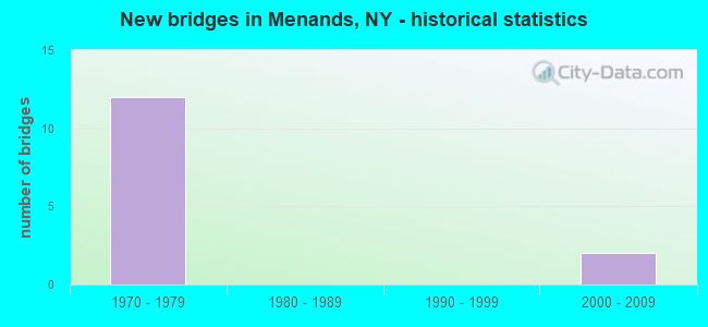
- New bridges - historical statistics
- 121970-1979
- 22000-2009


- Bridge Condition - Deck
- 37.5%Very good
- 25.0%Good
- 37.5%Satisfactory

- Bridge Condition - Superstructure
- 11.1%Very good
- 33.3%Good
- 33.3%Satisfactory
- 22.2%Fair

- Bridge Condition - Substructure
- 22.2%Very good
- 33.3%Good
- 44.4%Satisfactory
Find on map >> Show street view
Structure Number: 100014, Location: .9 MI S JCT SH 32 & SH378 (Lat: 42.687778, Lng: -73.727858), Route carried "on" structure: State highway 32, Year Built: 2002, Status: Open, Structure Length: 1.52m (4.99ft), Average Daily Traffic: 7,162 (year 2020), Truck Traffic: 12%, Average Future Daily Traffic: 8,700 (year 2040), Design Load: HS 25 or greater, Features Intersected: DELAWARE & HUDSON
Minimum Vertical Clearance: 30+ m (98+ ft), Kilometerpoint: 44.183, Lanes on structure: 2, Base Highway Network: Yes, Owner: State Highway Agency, Approaching Roadway Width: 15.8m (51.8ft), Skew: 6 degrees, Material/Design: Concrete, Design/Construction: Frame, Number Of Spans In Main Unit: 1, Length of Maximum Span: 14.6m (47.9ft), Curb or Sidewalk Widths: Left: 1.5m (4.9ft), Right: 1.5m (4.9ft), Curb-To-Curb Width: 16.0m (52.5ft), Out-to-Out Width: 34.5m (113.2ft)
Condition: Superstructure: Good, Substructure: Satisfactory, Operating Rating: 70.8 metric tons, Method Used To Determine Operating Rating: Load Factor (LF), Inventory Rating: 42.6 metric tons, Method Used To Determine Inventory Rating: Load Factor (LF), Structural Evaluation: Equal to present minimum criteria, Deck Geometry: Superior to present desirable criteria, Underclear: Meets minimum limits, Approach Roadway Alignment: Equal to present desirable criteria, Length Of Structure Improvement: 1.52m (4.99ft), Designated Inspection Frequency: Every 24 months, Inspection Date: July 2020, Bridge Improvement Cost: $6,784,000, Roadway Improvement Cost: $3,973,000, Total Project Cost: $10,757,000 ( Estimate for 2021), Wearing Surface/Protective System: Wearing Surface: Bituminous
Find on map >> Show street view
Structure Number: 1047029, Location: .1 MI E JCT SH377 & SH378 (Lat: 42.697206, Lng: -73.725925), Route carried "on" structure: State highway 378, Year Built: 2004, Status: Open, Structure Length: 2.90m (9.51ft), Average Daily Traffic: 9,475 (year 2018), Truck Traffic: 3%, Average Future Daily Traffic: 11,510 (year 2040), Design Load: HS 25 or greater, Features Intersected: DELAWARE & HUDSON
Minimum Vertical Clearance: 30+ m (98+ ft), Kilometerpoint: 2.574, Lanes on structure: 4, Base Highway Network: Yes, Owner: State Highway Agency, Approaching Roadway Width: 20.1m (65.9ft), Skew: 32 degrees, Material/Design: Prestressed concrete, Design/Construction: Box Beam or Girders - Multiple, Number Of Spans In Main Unit: 1, Length of Maximum Span: 27.1m (88.9ft), Curb-To-Curb Width: 21.0m (68.9ft), Out-to-Out Width: 21.3m (69.9ft)
Condition: Deck: Satisfactory, Superstructure: Very good, Substructure: Very good, Operating Rating: 97.2 metric tons, Method Used To Determine Operating Rating: Load and Resistance Factor Rating (LRFR) rating reported by rating factor(RF) method using HL-93 loadings, Inventory Rating: 88.5 metric tons, Method Used To Determine Inventory Rating: Load and Resistance Factor Rating (LRFR) rating reported by rating factor(RF) method using HL-93 loadings, Structural Evaluation: Equal to present desirable criteria, Deck Geometry: Superior to present desirable criteria, Underclear: Somewhat better than minimum adequacy, Approach Roadway Alignment: Equal to present desirable criteria, Length Of Structure Improvement: 2.89m (9.48ft), Designated Inspection Frequency: Every 24 months, Inspection Date: July 2020, Bridge Improvement Cost: $2,916,000, Roadway Improvement Cost: $1,708,000, Total Project Cost: $4,624,000 ( Estimate for 2021), Deck Structure Type: Concrete Cast-file-Place, Wearing Surface/Protective System: Wearing Surface: Integral Concrete, Deck Protection: Epoxy Coated Reinforcing
Find on map >> Show street view
Structure Number: 106285A, Location: JCT SH 378 & HUDSON RIVER (Lat: 42.700933, Lng: -73.704917), Route carried "on" structure: Ramp State highway 378, Year Built: 1971, Year Reconstructed: 2013, Status: Open, Structure Length: 4.66m (15.29ft), Average Daily Traffic: 23,843 (year 2010), Truck Traffic: 5%, Average Future Daily Traffic: 27,629 (year 2040), Design Load: HS 20+Mod, Features Intersected: HUDSON RIVER, Hudson Riv
Minimum Vertical Clearance: 30+ m (98+ ft), Kilometerpoint: 0.000, Lanes on structure: 1, Owner: State Highway Agency, Approaching Roadway Width: 6.1m (20.0ft), Skew: 2 degrees, Navigation Control: Yes ( Vertical Clearance: 999.9m (3,280.5ft), Horizontal Clearance: 89.9m (294.9ft)), Material/Design: Steel, Design/Construction: Girder and Floorbeam System, Number Of Spans In Main Unit: 2, Length of Maximum Span: 22.6m (74.1ft), Curb or Sidewalk Widths: Left: 0.0m, Right: 2.3m (7.5ft), Curb-To-Curb Width: 5.8m (19.0ft), Out-to-Out Width: 9.5m (31.2ft)
Condition: Deck: Very good, Superstructure: Good, Substructure: Good, Channel: Good, Operating Rating: 88.5 metric tons, Method Used To Determine Operating Rating: Field evaluation and documented engineering judgment, Inventory Rating: 32.7 metric tons, Method Used To Determine Inventory Rating: Field evaluation and documented engineering judgment, Structural Evaluation: Better than present minimum criteria, Deck Geometry: Meets minimum limits, Waterway Adequacy: Superior to present desirable criteria, Approach Roadway Alignment: Equal to present desirable criteria, Length Of Structure Improvement: 4.66m (15.29ft), Designated Inspection Frequency: Every 24 months, Critical Feature Inspection Frequency: Every 24 months, Inspection Date: November 2021, Critical Feature Inspection Date: November 2021, Bridge Improvement Cost: $1,005,000, Roadway Improvement Cost: $588,000, Total Project Cost: $1,593,000 ( Estimate for 2021), Deck Structure Type: Steel plate, Wearing Surface/Protective System: Wearing Surface: Integral Concrete
Find on map >> Show street view
Structure Number: 1092371, Location: JCT I787 & 378 (Lat: 42.700431, Lng: -73.708114), Route carried "on" structure: State highway 378, Year Built: 1971, Status: Open, Structure Length: 5.46m (17.91ft), Average Daily Traffic: 11,309 (year 2015), Truck Traffic: 4%, Average Future Daily Traffic: 13,104 (year 2040), Design Load: HS 20, Features Intersected: 787I787I11012021 SB, RTE
Minimum Vertical Clearance: 30+ m (98+ ft), Kilometerpoint: 4.023, Lanes on structure: 3, Lanes under structure: 7, Base Highway Network: Yes, Owner: State Highway Agency, Approaching Roadway Width: 15.2m (49.9ft), Skew: 2 degrees, Material/Design: Steel, Design/Construction: Stringer/Multi-beam, Number Of Spans In Main Unit: 1, Length of Maximum Span: 53.0m (173.9ft), Curb-To-Curb Width: 13.9m (45.6ft), Out-to-Out Width: 14.8m (48.6ft)
Condition: Deck: Very good, Superstructure: Fair, Substructure: Satisfactory, Operating Rating: 68.0 metric tons, Method Used To Determine Operating Rating: Load and Resistance Factor Rating (LRFR) rating reported by rating factor(RF) method using HL-93 loadings, Inventory Rating: 52.5 metric tons, Method Used To Determine Inventory Rating: Load and Resistance Factor Rating (LRFR) rating reported by rating factor(RF) method using HL-93 loadings, Structural Evaluation: Somewhat better than minimum adequacy, Deck Geometry: Somewhat better than minimum adequacy, Underclear: Meets minimum limits, Approach Roadway Alignment: Equal to present desirable criteria, Length Of Structure Improvement: 5.45m (17.88ft), Designated Inspection Frequency: Every 24 months, Inspection Date: October 2021, Bridge Improvement Cost: $2,207,000, Roadway Improvement Cost: $1,293,000, Total Project Cost: $3,500,000 ( Estimate for 2021), Deck Structure Type: Concrete Cast-file-Place, Wearing Surface/Protective System: Wearing Surface: Monolithic Concrete
Find on map >> Show street view
Structure Number: 1092372, Location: JCT I787 & 378 (Lat: 42.699747, Lng: -73.708039), Route carried "on" structure: State highway 378, Year Built: 1971, Status: Open, Structure Length: 6.58m (21.59ft), Average Daily Traffic: 11,309 (year 2015), Truck Traffic: 4%, Average Future Daily Traffic: 13,104 (year 2040), Design Load: HS 20, Features Intersected: 787I787I11012021 SB, RTE
Minimum Vertical Clearance: 30+ m (98+ ft), Kilometerpoint: 4.023, Lanes on structure: 3, Lanes under structure: 7, Base Highway Network: Yes, Owner: State Highway Agency, Approaching Roadway Width: 15.8m (51.8ft), Skew: 2 degrees, Material/Design: Steel, Design/Construction: Stringer/Multi-beam, Number Of Spans In Main Unit: 1, Length of Maximum Span: 64.0m (210.0ft), Curb-To-Curb Width: 13.9m (45.6ft), Out-to-Out Width: 14.8m (48.6ft)
Condition: Deck: Satisfactory, Superstructure: Fair, Substructure: Good, Operating Rating: 57.3 metric tons, Method Used To Determine Operating Rating: Load and Resistance Factor Rating (LRFR) rating reported by rating factor(RF) method using HL-93 loadings, Inventory Rating: 44.1 metric tons, Method Used To Determine Inventory Rating: Load and Resistance Factor Rating (LRFR) rating reported by rating factor(RF) method using HL-93 loadings, Structural Evaluation: Somewhat better than minimum adequacy, Deck Geometry: Somewhat better than minimum adequacy, Underclear: Somewhat better than minimum adequacy, Approach Roadway Alignment: Equal to present desirable criteria, Length Of Structure Improvement: 6.58m (21.59ft), Designated Inspection Frequency: Every 24 months, Inspection Date: October 2021, Bridge Improvement Cost: $2,526,000, Roadway Improvement Cost: $1,479,000, Total Project Cost: $4,006,000 ( Estimate for 2021), Deck Structure Type: Concrete Cast-file-Place, Wearing Surface/Protective System: Wearing Surface: Monolithic Concrete
Find on map >> Show street view
Structure Number: 1092389, Location: .07MI. N.ALBANY OVER I787 (Lat: 42.682939, Lng: -73.721992), Route carried "on" structure: Ramp State highway 913T, Year Built: 1971, Status: Open, Structure Length: 5.43m (17.81ft), Average Daily Traffic: 2,450 (year 2018), Truck Traffic: 18%, Average Future Daily Traffic: 3,882 (year 2040), Design Load: HS 20, Features Intersected: 787I787I11012007 SB, RTE
Minimum Vertical Clearance: 30+ m (98+ ft), Kilometerpoint: 0.290, Lanes on structure: 2, Lanes under structure: 6, Owner: State Highway Agency, Approaching Roadway Width: 11.6m (38.1ft), Skew: 30 degrees, Material/Design: Steel, Design/Construction: Stringer/Multi-beam, Number Of Spans In Main Unit: 1, Length of Maximum Span: 52.7m (172.9ft), Curb or Sidewalk Widths: Left: 0.0m, Right: 2.7m (8.9ft), Curb-To-Curb Width: 11.4m (37.4ft), Out-to-Out Width: 17.7m (58.1ft)
Condition: Deck: Good, Superstructure: Satisfactory, Substructure: Satisfactory, Operating Rating: 50.9 metric tons, Method Used To Determine Operating Rating: Load and Resistance Factor Rating (LRFR) rating reported by rating factor(RF) method using HL-93 loadings, Inventory Rating: 39.2 metric tons, Method Used To Determine Inventory Rating: Load and Resistance Factor Rating (LRFR) rating reported by rating factor(RF) method using HL-93 loadings, Structural Evaluation: Equal to present minimum criteria, Deck Geometry: Superior to present desirable criteria, Underclear: High priority of corrective action, Approach Roadway Alignment: Better than present minimum criteria, Length Of Structure Improvement: 5.42m (17.78ft), Designated Inspection Frequency: Every 24 months, Inspection Date: July 2021, Bridge Improvement Cost: $2,765,000, Roadway Improvement Cost: $1,619,000, Total Project Cost: $4,385,000 ( Estimate for 2021), Deck Structure Type: Concrete Cast-file-Place, Wearing Surface/Protective System: Wearing Surface: Epoxy Overlay
Find on map >> Show street view
Structure Number: 109239, Location: 0.3 MI W JCT I787 & 378 (Lat: 42.699294, Lng: -73.711022), Route carried "on" structure: US 378, Year Built: 1971, Status: Open, Structure Length: 4.27m (14.01ft), Average Daily Traffic: 11,104 (year 2015), Truck Traffic: 4%, Average Future Daily Traffic: 13,489 (year 2040), Features Intersected: 378 WB TO I787 SB
Minimum Vertical Clearance: 30+ m (98+ ft), Kilometerpoint: 3.797, Lanes on structure: 2, Lanes under structure: 2, Base Highway Network: Yes, Owner: State Highway Agency, Approaching Roadway Width: 11.9m (39.0ft), Skew: 4 degrees, Material/Design: Steel, Design/Construction: Stringer/Multi-beam, Number Of Spans In Main Unit: 1, Length of Maximum Span: 41.4m (135.8ft), Curb-To-Curb Width: 11.9m (39.0ft), Out-to-Out Width: 12.8m (42.0ft)
Condition: Deck: Very good, Superstructure: Satisfactory, Substructure: Good, Inventory Rating: 68.0 metric tons, Method Used To Determine Inventory Rating: Load Factor (LF), Structural Evaluation: Equal to present minimum criteria, Deck Geometry: Better than present minimum criteria, Underclear: High priority of corrective action, Approach Roadway Alignment: Equal to present desirable criteria, Length Of Structure Improvement: 4.26m (13.98ft), Designated Inspection Frequency: Every 24 months, Inspection Date: November 2020, Bridge Improvement Cost: $1,491,000, Roadway Improvement Cost: $873,000, Total Project Cost: $2,364,000 ( Estimate for 2021), Deck Structure Type: Concrete Cast-file-Place, Wearing Surface/Protective System: Wearing Surface: Monolithic Concrete
Find on map >> Show street view
Structure Number: 1092409, Location: 0.9 MI W JCT I787 & 378 (Lat: 42.698125, Lng: -73.719483), Route carried "on" structure: State highway 378, Year Built: 1971, Status: Open, Structure Length: 4.91m (16.11ft), Average Daily Traffic: 11,104 (year 2018), Truck Traffic: 4%, Average Future Daily Traffic: 13,489 (year 2040), Design Load: HS 20, Features Intersected: RTE 32
Minimum Vertical Clearance: 30+ m (98+ ft), Kilometerpoint: 3.089, Lanes on structure: 6, Lanes under structure: 5, Base Highway Network: Yes, Owner: State Highway Agency, Approaching Roadway Width: 25.9m (85.0ft), Skew: 34 degrees, Material/Design: Steel, Design/Construction: Stringer/Multi-beam, Number Of Spans In Main Unit: 1, Length of Maximum Span: 47.2m (154.9ft), Curb-To-Curb Width: 25.9m (85.0ft), Out-to-Out Width: 27.7m (90.9ft)
Condition: Deck: Satisfactory, Superstructure: Satisfactory, Substructure: Satisfactory, Operating Rating: 91.6 metric tons, Method Used To Determine Operating Rating: Load Factor (LF), Inventory Rating: 54.4 metric tons, Method Used To Determine Inventory Rating: Load Factor (LF), Structural Evaluation: Equal to present minimum criteria, Deck Geometry: Equal to present minimum criteria, Underclear: Meets minimum limits, Approach Roadway Alignment: Equal to present desirable criteria, Length Of Structure Improvement: 4.90m (16.08ft), Designated Inspection Frequency: Every 24 months, Inspection Date: June 2021, Bridge Improvement Cost: $3,901,000, Roadway Improvement Cost: $2,284,000, Total Project Cost: $6,185,000 ( Estimate for 2021), Deck Structure Type: Concrete Cast-file-Place, Wearing Surface/Protective System: Wearing Surface: Monolithic Concrete
Find on map >> Show street view
Structure Number: 1092419, Location: .1 MI SE JCT SH32 & SH913 (Lat: 42.684819, Lng: -73.728622), Route carried "on" structure: Ramp State highway 913T, Year Built: 1970, Status: Open, Structure Length: 6.37m (20.90ft), Average Daily Traffic: 11,806 (year 2018), Truck Traffic: 8%, Average Future Daily Traffic: 14,341 (year 2040), Design Load: HS 20, Features Intersected: DELAWARE & HUDSON RR
Minimum Vertical Clearance: 30+ m (98+ ft), Kilometerpoint: 0.080, Lanes on structure: 6, Base Highway Network: Yes, Owner: State Highway Agency, Approaching Roadway Width: 24.4m (80.1ft), Skew: 30 degrees, Material/Design: Steel, Design/Construction: Stringer/Multi-beam, Number Of Spans In Main Unit: 3, Length of Maximum Span: 32.9m (107.9ft), Curb-To-Curb Width: 25.9m (85.0ft), Out-to-Out Width: 27.6m (90.6ft)
Condition: Deck: Good, Superstructure: Good, Substructure: Very good, Operating Rating: 58.1 metric tons, Method Used To Determine Operating Rating: Load Factor (LF), Inventory Rating: 34.5 metric tons, Method Used To Determine Inventory Rating: Load Factor (LF), Structural Evaluation: Better than present minimum criteria, Deck Geometry: Equal to present desirable criteria, Underclear: Equal to present minimum criteria, Approach Roadway Alignment: Equal to present desirable criteria, Length Of Structure Improvement: 6.37m (20.90ft), Designated Inspection Frequency: Every 24 months, Inspection Date: July 2020, Bridge Improvement Cost: $3,882,000, Roadway Improvement Cost: $2,274,000, Total Project Cost: $6,156,000 ( Estimate for 2021), Deck Structure Type: Concrete Cast-file-Place, Wearing Surface/Protective System: Wearing Surface: Integral Concrete
Find on map >> Show street view
Structure Number: 1092371, Location: JCT I787 & 378 (Lat: 42.700431, Lng: -73.708114), Route carried "under" structure: Interstate 787, Year Built: 1971, Structure Length: 0. m, Average Daily Traffic: 90,172 (year 2002), Features Intersected: 787I787I11012021 SB, RTE, Facility Carried by Structure: RTE 378
Minimum Vertical Clearance: 5.11m (16.77ft), Kilometerpoint: 3.282, Lanes on structure: 3, Lanes under structure: 4, Material/Design: Steel, Design/Construction: Stringer/Multi-beam, Length of Maximum Span: 53.0m (173.9ft)
Find on map >> Show street view
Structure Number: 1092372, Location: JCT I787 & 378 (Lat: 42.699747, Lng: -73.708039), Route carried "under" structure: Interstate 787, Year Built: 1971, Structure Length: 0. m, Average Daily Traffic: 83,897 (year 2002), Features Intersected: 787I787I11012021 SB, RTE, Facility Carried by Structure: RTE 378
Minimum Vertical Clearance: 6.38m (20.93ft), Kilometerpoint: 3.379, Lanes on structure: 3, Lanes under structure: 4, Material/Design: Steel, Design/Construction: Stringer/Multi-beam, Length of Maximum Span: 64.0m (210.0ft)
Find on map >> Show street view
Structure Number: 1092389, Location: .07MI. N.ALBANY OVER I787 (Lat: 42.682939, Lng: -73.721992), Route carried "under" structure: Interstate 787, Year Built: 1971, Structure Length: 0. m, Average Daily Traffic: 98,396 (year 2012), Features Intersected: 787I787I11012007 SB, RTE, Facility Carried by Structure: RTE 913T
Minimum Vertical Clearance: 4.80m (15.75ft), Kilometerpoint: 1.094, Lanes on structure: 2, Lanes under structure: 3, Material/Design: Steel, Design/Construction: Stringer/Multi-beam, Length of Maximum Span: 52.7m (172.9ft)
Find on map >> Show street view
Structure Number: 109239, Location: 0.3 MI W JCT I787 & 378 (Lat: 42.699294, Lng: -73.711022), Route carried "under" structure: Ramp Interstate , Year Built: 1971, Structure Length: 0. m, Average Daily Traffic: 6,470 (year 1980), Features Intersected: 378 WB TO I787 SB, Facility Carried by Structure: RTE 378
Minimum Vertical Clearance: 5.05m (16.57ft), Kilometerpoint: 0.000, Lanes on structure: 2, Lanes under structure: 2, Material/Design: Steel, Design/Construction: Stringer/Multi-beam, Length of Maximum Span: 41.4m (135.8ft)
Find on map >> Show street view
Structure Number: 1092409, Location: 0.9 MI W JCT I787 & 378 (Lat: 42.698125, Lng: -73.719483), Route carried "under" structure: State highway 32, Year Built: 1971, Structure Length: 0. m, Average Daily Traffic: 9,314 (year 2000), Features Intersected: RTE 32, Facility Carried by Structure: RTE 378
Minimum Vertical Clearance: 4.75m (15.58ft), Kilometerpoint: 2.800, Lanes on structure: 6, Lanes under structure: 5, Material/Design: Steel, Design/Construction: Stringer/Multi-beam, Length of Maximum Span: 47.2m (154.9ft)