Bridge Statistics for Mendon, New York (NY)
Condition, Traffic, Stress, Structural Evaluation, Project Costs
- National Bridge Inventory (NBI) Statistics
- 17Number of bridges
- 131ft / 40.2mTotal length
- $19,384,000Total costs
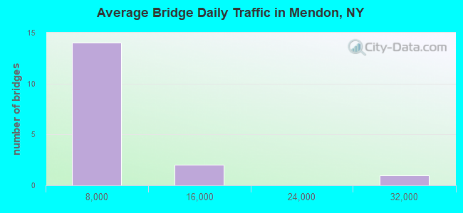
- 89,424Total average daily traffic
- 1,603Total average daily truck traffic
- National Bridge Inventory (NBI) Registered Bridges for Mendon
- No street view available for this location
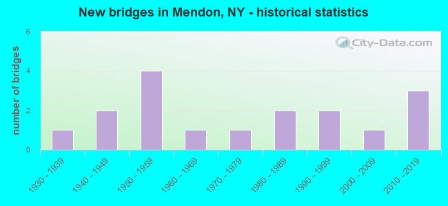
- New bridges - historical statistics
- 11930-1939
- 21940-1949
- 41950-1959
- 11960-1969
- 11970-1979
- 21980-1989
- 21990-1999
- 12000-2009
- 32010-2019
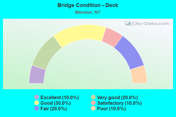
- Bridge Condition - Deck
- 10.0%Excellent
- 20.0%Very good
- 30.0%Good
- 10.0%Satisfactory
- 20.0%Fair
- 10.0%Poor
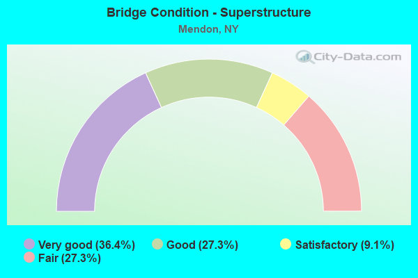
- Bridge Condition - Superstructure
- 36.4%Very good
- 27.3%Good
- 9.1%Satisfactory
- 27.3%Fair
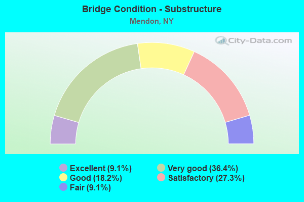
- Bridge Condition - Substructure
- 9.1%Excellent
- 36.4%Very good
- 18.2%Good
- 27.3%Satisfactory
- 9.1%Fair
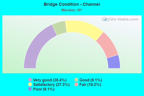
- Bridge Condition - Channel
- 36.4%Very good
- 9.1%Good
- 27.3%Satisfactory
- 18.2%Fair
- 9.1%Poor
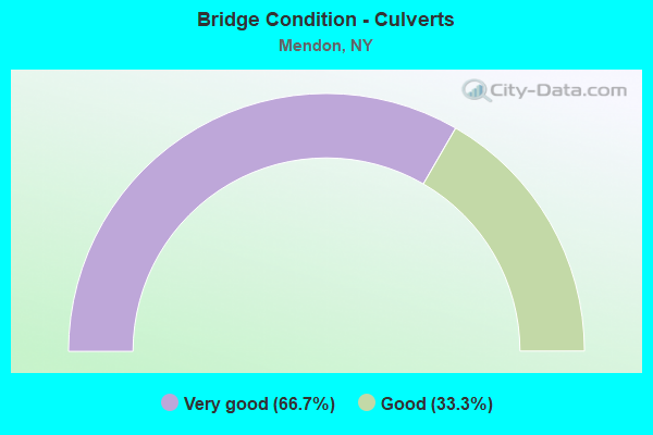
- Bridge Condition - Culverts
- 66.7%Very good
- 33.3%Good
Find on map >> Show street view
Structure Number: 10116, Location: 5.5MI N JCT RTS 15& 5&20 (Lat: 42.958208, Lng: -77.620158), Route carried "on" structure: Alternate State highway 15A, Year Built: 2010, Status: Open, Structure Length: 2.71m (8.89ft), Average Daily Traffic: 4,786 (year 2020), Truck Traffic: 7%, Average Future Daily Traffic: 4,815 (year 2040), Design Load: HL 93, Features Intersected: SPRING CREEK
Minimum Vertical Clearance: 30+ m (98+ ft), Kilometerpoint: 1.706, Lanes on structure: 2, Base Highway Network: Yes, Owner: State Highway Agency, Approaching Roadway Width: 10.1m (33.1ft), Skew: 4 degrees, Material/Design: Prestressed concrete, Design/Construction: Box Beam or Girders - Multiple, Number Of Spans In Main Unit: 1, Length of Maximum Span: 25.9m (85.0ft), Curb-To-Curb Width: 10.4m (34.1ft), Out-to-Out Width: 11.4m (37.4ft)
Condition: Deck: Very good, Superstructure: Very good, Substructure: Very good, Channel: Fair, Operating Rating: 94.0 metric tons, Method Used To Determine Operating Rating: Load Factor (LF), Inventory Rating: 61.0 metric tons, Method Used To Determine Inventory Rating: Load Factor (LF), Structural Evaluation: Equal to present desirable criteria, Deck Geometry: Somewhat better than minimum adequacy, Waterway Adequacy: Meets minimum limits, Approach Roadway Alignment: Equal to present desirable criteria, Length Of Structure Improvement: 2.71m (8.89ft), Designated Inspection Frequency: Every 24 months, Inspection Date: October 2020, Bridge Improvement Cost: $787,000, Roadway Improvement Cost: $461,000, Total Project Cost: $1,249,000 ( Estimate for 2021), Deck Structure Type: Concrete Cast-file-Place, Wearing Surface/Protective System: Wearing Surface: Monolithic Concrete, Deck Protection: Epoxy Coated Reinforcing
Find on map >> Show street view
Structure Number: 10289, Location: 0.1MI S JCT RTS 64 + 251 (Lat: 42.997058, Lng: -77.504294), Route carried "on" structure: State highway 64, Year Built: 2013, Status: Open, Structure Length: 1.16m (3.81ft), Average Daily Traffic: 3,764 (year 2017), Truck Traffic: 4%, Average Future Daily Traffic: 4,657 (year 2040), Design Load: HL 93, Features Intersected: IRONDEQUOIT CREEK
Minimum Vertical Clearance: 30+ m (98+ ft), Kilometerpoint: 6.307, Lanes on structure: 2, Base Highway Network: Yes, Owner: State Highway Agency, Approaching Roadway Width: 10.1m (33.1ft), Material/Design: Concrete, Design/Construction: Frame, Number Of Spans In Main Unit: 1, Length of Maximum Span: 11.3m (37.1ft), Curb or Sidewalk Widths: Left: 1.7m (5.6ft), Right: 0.0m, Curb-To-Curb Width: 10.1m (33.1ft), Out-to-Out Width: 13.2m (43.3ft)
Condition: Deck: Excellent, Superstructure: Very good, Substructure: Excellent, Channel: Good, Operating Rating: 80.6 metric tons, Method Used To Determine Operating Rating: Field evaluation and documented engineering judgment, Inventory Rating: 40.8 metric tons, Method Used To Determine Inventory Rating: Field evaluation and documented engineering judgment, Structural Evaluation: Equal to present desirable criteria, Deck Geometry: Meets minimum limits, Waterway Adequacy: Equal to present minimum criteria, Approach Roadway Alignment: Equal to present desirable criteria, Length Of Structure Improvement: 1.15m (3.77ft), Designated Inspection Frequency: Every 24 months, Inspection Date: May 2021, Bridge Improvement Cost: $563,000, Roadway Improvement Cost: $330,000, Total Project Cost: $892,000 ( Estimate for 2021), Wearing Surface/Protective System: Wearing Surface: Bituminous
Find on map >> Show street view
Structure Number: 102891, Location: JCT RTE64+NYS THRUWAY (Lat: 43.030997, Lng: -77.515625), Route carried "on" structure: State highway 64, Year Built: 1952, Status: Open, Structure Length: 6.49m (21.29ft), Average Daily Traffic: 4,045 (year 2020), Truck Traffic: 4%, Average Future Daily Traffic: 4,913 (year 2040), Design Load: HS 20+Mod, Features Intersected: 90IX, RTE I90
Minimum Vertical Clearance: 30+ m (98+ ft), Kilometerpoint: 10.249, Lanes on structure: 2, Lanes under structure: 8, Base Highway Network: Yes, Owner: State Toll Authority, Approaching Roadway Width: 8.5m (27.9ft), Skew: 2 degrees, Material/Design: Concrete, Design/Construction: Frame, Number Of Spans In Main Unit: 2, Length of Maximum Span: 28.0m (91.9ft), Curb-To-Curb Width: 8.5m (27.9ft), Out-to-Out Width: 17.2m (56.4ft)
Condition: Superstructure: Fair, Substructure: Satisfactory, Operating Rating: 90.5 metric tons, Method Used To Determine Operating Rating: Field evaluation and documented engineering judgment, Inventory Rating: 29.4 metric tons, Method Used To Determine Inventory Rating: Field evaluation and documented engineering judgment, Structural Evaluation: Somewhat better than minimum adequacy, Deck Geometry: Meets minimum limits, Underclear: High priority of corrective action, Approach Roadway Alignment: Equal to present minimum criteria, Length Of Structure Improvement: 6.49m (21.29ft), Designated Inspection Frequency: Every 24 months, Inspection Date: July 2020, Bridge Improvement Cost: $3,031,000, Roadway Improvement Cost: $1,775,000, Total Project Cost: $4,806,000 ( Estimate for 2021), Wearing Surface/Protective System: Wearing Surface: Bituminous
Find on map >> Show street view
Structure Number: 102896, Location: 2.0 MI N OF HONEYE FALLS (Lat: 42.981464, Lng: -77.583981), Route carried "on" structure: Alternate State highway 65, Year Built: 1977, Status: Open, Structure Length: 1.43m (4.69ft), Average Daily Traffic: 3,703 (year 2017), Truck Traffic: 4%, Average Future Daily Traffic: 3,862 (year 2040), Design Load: HS 20, Features Intersected: BR OF HONEOYE CK
Minimum Vertical Clearance: 30+ m (98+ ft), Kilometerpoint: 4.811, Lanes on structure: 2, Base Highway Network: Yes, Owner: State Highway Agency, Approaching Roadway Width: 12.2m (40.0ft), Skew: 2 degrees, Material/Design: Concrete, Design/Construction: Culvert, Number Of Spans In Main Unit: 3, Length of Maximum Span: 4.2m (13.8ft)
Condition: Channel: Poor, Culverts: Good, Operating Rating: 75.6 metric tons, Method Used To Determine Operating Rating: Field evaluation and documented engineering judgment, Inventory Rating: 32.7 metric tons, Method Used To Determine Inventory Rating: Field evaluation and documented engineering judgment, Structural Evaluation: Better than present minimum criteria, Waterway Adequacy: Meets minimum limits, Approach Roadway Alignment: Equal to present desirable criteria, Length Of Structure Improvement: 1.43m (4.69ft), Designated Inspection Frequency: Every 24 months, Inspection Date: May 2020, Bridge Improvement Cost: $313,000, Roadway Improvement Cost: $183,000, Total Project Cost: $497,000 ( Estimate for 2021), Wearing Surface/Protective System: Wearing Surface: Bituminous
Find on map >> Show street view
Structure Number: 10434, Location: 0.1MI E JCT RTS 251 & 64 (Lat: 42.997814, Lng: -77.503911), Route carried "on" structure: State highway 251, Year Built: 1995, Status: Open, Structure Length: 1.77m (5.81ft), Average Daily Traffic: 5,079 (year 2017), Truck Traffic: 5%, Average Future Daily Traffic: 6,169 (year 2040), Design Load: HS 25 or greater, Features Intersected: IRONDEQUOIT CREEK
Minimum Vertical Clearance: 30+ m (98+ ft), Kilometerpoint: 22.429, Lanes on structure: 2, Base Highway Network: Yes, Owner: State Highway Agency, Approaching Roadway Width: 9.8m (32.2ft), Material/Design: Prestressed concrete, Design/Construction: Box Beam or Girders - Multiple, Number Of Spans In Main Unit: 1, Length of Maximum Span: 16.4m (53.8ft), Curb or Sidewalk Widths: Left: 1.5m (4.9ft), Right: 1.5m (4.9ft), Curb-To-Curb Width: 9.8m (32.2ft), Out-to-Out Width: 13.5m (44.3ft)
Condition: Deck: Very good, Superstructure: Very good, Substructure: Very good, Channel: Very good, Inventory Rating: 62.6 metric tons, Method Used To Determine Inventory Rating: Load Factor (LF), Structural Evaluation: Equal to present desirable criteria, Deck Geometry: Meets minimum limits, Waterway Adequacy: Somewhat better than minimum adequacy, Approach Roadway Alignment: Equal to present desirable criteria, Length Of Structure Improvement: 1.76m (5.77ft), Designated Inspection Frequency: Every 24 months, Inspection Date: November 2021, Bridge Improvement Cost: $478,000, Roadway Improvement Cost: $280,000, Total Project Cost: $757,000 ( Estimate for 2021), Wearing Surface/Protective System: Wearing Surface: Bituminous, Membrane: Preformed Fabric
Find on map >> Show street view
Structure Number: 104974, Location: 1.5MI W HONEOYE FALLS (Lat: 42.960144, Lng: -77.619483), Route carried "on" structure: State highway 940J, Year Built: 2010, Status: Open, Structure Length: 1.25m (4.10ft), Average Daily Traffic: 2,396 (year 2018), Truck Traffic: 5%, Average Future Daily Traffic: 2,419 (year 2040), Design Load: HS 25 or greater, Features Intersected: SPRING CREEK
Minimum Vertical Clearance: 30+ m (98+ ft), Kilometerpoint: 0.048, Lanes on structure: 2, Base Highway Network: Yes, Owner: State Highway Agency, Approaching Roadway Width: 9.1m (29.9ft), Skew: 1 degrees, Material/Design: Concrete, Design/Construction: Culvert, Number Of Spans In Main Unit: 1, Length of Maximum Span: 11.9m (39.0ft), Curb-To-Curb Width: 8.9m (29.2ft), Out-to-Out Width: 9.8m (32.2ft)
Condition: Channel: Very good, Culverts: Very good, Operating Rating: 69.9 metric tons, Method Used To Determine Operating Rating: Load Factor (LF), Inventory Rating: 41.7 metric tons, Method Used To Determine Inventory Rating: Load Factor (LF), Structural Evaluation: Equal to present desirable criteria, Deck Geometry: Meets minimum limits, Waterway Adequacy: Equal to present minimum criteria, Approach Roadway Alignment: Equal to present desirable criteria, Length Of Structure Improvement: 1.24m (4.07ft), Designated Inspection Frequency: Every 24 months, Inspection Date: July 2020, Bridge Improvement Cost: $221,000, Roadway Improvement Cost: $129,000, Total Project Cost: $350,000 ( Estimate for 2021), Wearing Surface/Protective System: Wearing Surface: Bituminous
Find on map >> Show street view
Structure Number: 331713, Location: 1 MI NE OF MENDON (Lat: 43.010086, Lng: -77.494114), Route carried "on" structure: Other road , Year Built: 1933, Status: Open, Structure Length: 0.91m (2.99ft), Average Daily Traffic: 1,119 (year 2017), Truck Traffic: 3%, Average Future Daily Traffic: 1,384 (year 2040), Features Intersected: IRONDEQUOIT CREEK, Facility Carried by Structure: MILE SQUARE RD
Minimum Vertical Clearance: 30+ m (98+ ft), Kilometerpoint: 1.368, Lanes on structure: 2, Owner: County Highway Agency, Approaching Roadway Width: 6.1m (20.0ft), Material/Design: Concrete, Design/Construction: Girder and Floorbeam System, Number Of Spans In Main Unit: 1, Length of Maximum Span: 8.5m (27.9ft), Curb-To-Curb Width: 7.3m (24.0ft), Out-to-Out Width: 8.3m (27.2ft)
Condition: Deck: Fair, Superstructure: Fair, Substructure: Satisfactory, Channel: Satisfactory, Operating Rating: 67.6 metric tons, Method Used To Determine Operating Rating: Field evaluation and documented engineering judgment, Inventory Rating: 26.4 metric tons, Method Used To Determine Inventory Rating: Field evaluation and documented engineering judgment, Structural Evaluation: Somewhat better than minimum adequacy, Deck Geometry: Meets minimum limits, Waterway Adequacy: Equal to present minimum criteria, Approach Roadway Alignment: Somewhat better than minimum adequacy, Length Of Structure Improvement: 0.91m (2.99ft), Designated Inspection Frequency: Every 24 months, Inspection Date: November 2020, Bridge Improvement Cost: $307,000, Roadway Improvement Cost: $180,000, Total Project Cost: $486,000 ( Estimate for 2021), Deck Structure Type: Concrete Cast-file-Place, Wearing Surface/Protective System: Wearing Surface: Bituminous
Find on map >> Show street view
Structure Number: 331772, Location: 1.2 MI SE OF MENDON CTR. (Lat: 42.984294, Lng: -77.542697), Route carried "on" structure: Other road , Year Built: 1950, Status: Open, Structure Length: 0.85m (2.79ft), Average Daily Traffic: 406 (year 2019), Truck Traffic: 3%, Average Future Daily Traffic: 568 (year 2039), Features Intersected: IRONDEQUOIT CREEK, Facility Carried by Structure: TAYLOR ROAD
Minimum Vertical Clearance: 30+ m (98+ ft), Kilometerpoint: 0.064, Lanes on structure: 2, Owner: County Highway Agency, Approaching Roadway Width: 9.1m (29.9ft), Material/Design: Steel, Design/Construction: Stringer/Multi-beam, Number Of Spans In Main Unit: 1, Length of Maximum Span: 8.2m (26.9ft), Curb-To-Curb Width: 8.2m (26.9ft), Out-to-Out Width: 8.8m (28.9ft)
Condition: Deck: Poor, Superstructure: Fair, Substructure: Fair, Channel: Fair, Operating Rating: 47.2 metric tons, Method Used To Determine Operating Rating: Allowable Stress (AS), Inventory Rating: 22.7 metric tons, Method Used To Determine Inventory Rating: Allowable Stress (AS), Structural Evaluation: Somewhat better than minimum adequacy, Deck Geometry: Somewhat better than minimum adequacy, Waterway Adequacy: Better than present minimum criteria, Approach Roadway Alignment: Equal to present minimum criteria, Length Of Structure Improvement: 0.85m (2.79ft), Designated Inspection Frequency: Every 24 months, Inspection Date: June 2020, Bridge Improvement Cost: $315,000, Roadway Improvement Cost: $184,000, Total Project Cost: $499,000 ( Estimate for 2021), Deck Structure Type: Wood or Timber, Wearing Surface/Protective System: Wearing Surface: Bituminous
Find on map >> Show street view
Structure Number: 331773, Location: 2.2 MI NW Honeoye Falls (Lat: 42.983514, Lng: -77.600022), Route carried "on" structure: Other road , Year Built: 2003, Status: Open, Structure Length: 3.29m (10.79ft), Average Daily Traffic: 479 (year 2017), Truck Traffic: 2%, Average Future Daily Traffic: 671 (year 2037), Design Load: HS 25 or greater, Features Intersected: Honeoye Creek, Facility Carried by Structure: Plains Road
Minimum Vertical Clearance: 30+ m (98+ ft), Kilometerpoint: 1.850, Lanes on structure: 2, Owner: County Highway Agency, Approaching Roadway Width: 7.9m (25.9ft), Material/Design: Prestressed concrete, Design/Construction: Box Beam or Girders - Multiple, Number Of Spans In Main Unit: 1, Length of Maximum Span: 31.7m (104.0ft), Curb-To-Curb Width: 9.0m (29.5ft), Out-to-Out Width: 10.0m (32.8ft)
Condition: Deck: Satisfactory, Superstructure: Good, Substructure: Very good, Channel: Very good, Inventory Rating: 75.3 metric tons, Method Used To Determine Inventory Rating: Load Factor (LF), Structural Evaluation: Better than present minimum criteria, Deck Geometry: Somewhat better than minimum adequacy, Waterway Adequacy: Superior to present desirable criteria, Approach Roadway Alignment: Equal to present desirable criteria, Length Of Structure Improvement: 3.29m (10.79ft), Designated Inspection Frequency: Every 24 months, Inspection Date: May 2020, Bridge Improvement Cost: $914,000, Roadway Improvement Cost: $535,000, Total Project Cost: $1,450,000 ( Estimate for 2021), Deck Structure Type: Concrete Cast-file-Place, Wearing Surface/Protective System: Wearing Surface: Monolithic Concrete, Deck Protection: Other
Find on map >> Show street view
Structure Number: 331775, Location: 1.5 MI NW HONEOYE FALLS (Lat: 42.967025, Lng: -77.613536), Route carried "on" structure: County highway , Year Built: 1962, Year Reconstructed: 2015, Status: Open, Structure Length: 2.74m (8.99ft), Average Daily Traffic: 853 (year 2016), Truck Traffic: 3%, Average Future Daily Traffic: 1,194 (year 2036), Design Load: HS 20, Features Intersected: HONEOYE CREEK, Facility Carried by Structure: SIBLEY ROAD
Minimum Vertical Clearance: 30+ m (98+ ft), Kilometerpoint: 0.386, Lanes on structure: 2, Owner: County Highway Agency, Approaching Roadway Width: 6.7m (22.0ft), Skew: 1 degrees, Material/Design: Steel, Design/Construction: Stringer/Multi-beam, Number Of Spans In Main Unit: 1, Length of Maximum Span: 25.9m (85.0ft), Curb-To-Curb Width: 9.4m (30.8ft), Out-to-Out Width: 10.4m (34.1ft)
Condition: Deck: Good, Superstructure: Very good, Substructure: Very good, Channel: Very good, Operating Rating: 43.4 metric tons, Method Used To Determine Operating Rating: Load and Resistance Factor Rating (LRFR) rating reported by rating factor(RF) method using HL-93 loadings, Inventory Rating: 33.7 metric tons, Method Used To Determine Inventory Rating: Load and Resistance Factor Rating (LRFR) rating reported by rating factor(RF) method using HL-93 loadings, Structural Evaluation: Equal to present desirable criteria, Deck Geometry: Equal to present minimum criteria, Waterway Adequacy: Equal to present desirable criteria, Approach Roadway Alignment: Equal to present desirable criteria, Length Of Structure Improvement: 2.74m (8.99ft), Designated Inspection Frequency: Every 24 months, Inspection Date: May 2020, Bridge Improvement Cost: $970,000, Roadway Improvement Cost: $568,000, Total Project Cost: $1,539,000 ( Estimate for 2021), Deck Structure Type: Concrete Cast-file-Place, Wearing Surface/Protective System: Wearing Surface: Bituminous, Membrane: Epoxy
Find on map >> Show street view
Structure Number: 331776, Location: 1.5 SW OF HONEOYE FALLS (Lat: 42.945839, Lng: -77.618981), Route carried "on" structure: County highway , Year Built: 1958, Year Reconstructed: 2010, Status: Open, Structure Length: 1.04m (3.41ft), Average Daily Traffic: 2,426 (year 2017), Truck Traffic: 10%, Average Future Daily Traffic: 2,530 (year 2040), Design Load: HL 93, Features Intersected: SPRING BROOK, Facility Carried by Structure: HONEOYE FALLS RD
Minimum Vertical Clearance: 30+ m (98+ ft), Kilometerpoint: 8.640, Lanes on structure: 2, Owner: County Highway Agency, Approaching Roadway Width: 8.8m (28.9ft), Skew: 3 degrees, Material/Design: Prestressed concrete, Design/Construction: Box Beam or Girders - Multiple, Number Of Spans In Main Unit: 1, Length of Maximum Span: 10.0m (32.8ft), Curb-To-Curb Width: 9.1m (29.9ft), Out-to-Out Width: 10.2m (33.5ft)
Condition: Deck: Good, Superstructure: Good, Substructure: Satisfactory, Channel: Satisfactory, Operating Rating: 72.6 metric tons, Method Used To Determine Operating Rating: Load Factor (LF), Inventory Rating: 43.5 metric tons, Method Used To Determine Inventory Rating: Load Factor (LF), Structural Evaluation: Equal to present minimum criteria, Deck Geometry: Meets minimum limits, Waterway Adequacy: Equal to present desirable criteria, Approach Roadway Alignment: Equal to present desirable criteria, Length Of Structure Improvement: 1.03m (3.38ft), Designated Inspection Frequency: Every 24 months, Inspection Date: November 2020, Bridge Improvement Cost: $337,000, Roadway Improvement Cost: $198,000, Total Project Cost: $535,000 ( Estimate for 2021), Wearing Surface/Protective System: Wearing Surface: Bituminous
Find on map >> Show street view
Structure Number: 33696, Location: 4 MI NE OF HONEOYE FALLS (Lat: 42.975447, Lng: -77.528689), Route carried "on" structure: County highway , Year Built: 1999, Status: Open, Structure Length: 0.67m (2.20ft), Average Daily Traffic: 858 (year 2016), Truck Traffic: 4%, Average Future Daily Traffic: 1,201 (year 2036), Design Load: HS 25 or greater, Features Intersected: TR IRONDEQUOIT CK, Facility Carried by Structure: CHEESE FACTORY RD
Minimum Vertical Clearance: 30+ m (98+ ft), Kilometerpoint: 5.294, Lanes on structure: 2, Owner: County Highway Agency, Approaching Roadway Width: 10.1m (33.1ft), Skew: 2 degrees, Material/Design: Concrete, Design/Construction: Culvert, Number Of Spans In Main Unit: 1, Length of Maximum Span: 6.1m (20.0ft)
Condition: Channel: Satisfactory, Culverts: Very good, Operating Rating: 79.4 metric tons, Method Used To Determine Operating Rating: Load and Resistance Factor Rating (LRFR) rating reported by rating factor(RF) method using HL-93 loadings, Inventory Rating: 61.2 metric tons, Method Used To Determine Inventory Rating: Load and Resistance Factor Rating (LRFR) rating reported by rating factor(RF) method using HL-93 loadings, Structural Evaluation: Equal to present desirable criteria, Waterway Adequacy: Better than present minimum criteria, Approach Roadway Alignment: Equal to present desirable criteria, Length Of Structure Improvement: 0.67m (2.20ft), Designated Inspection Frequency: Every 24 months, Inspection Date: July 2021, Bridge Improvement Cost: $191,000, Roadway Improvement Cost: $112,000, Total Project Cost: $303,000 ( Estimate for 2021)
Find on map >> Show street view
Structure Number: 551089, Location: 4.7 MI W OF EXIT 45 90I (Lat: 43.033778, Lng: -77.523717), Route carried "on" structure: County highway , Year Built: 1989, Status: Open, Structure Length: 7.44m (24.41ft), Average Daily Traffic: 1,155 (year 2020), Truck Traffic: 4%, Average Future Daily Traffic: 1,429 (year 2040), Design Load: HS 20, Features Intersected: 90IX, RTE I90, Facility Carried by Structure: W BLOOMFIELD RD
Minimum Vertical Clearance: 30+ m (98+ ft), Kilometerpoint: 10.233, Lanes on structure: 2, Lanes under structure: 4, Owner: State Toll Authority, Approaching Roadway Width: 8.2m (26.9ft), Skew: 2 degrees, Material/Design: Steel continuous, Design/Construction: Stringer/Multi-beam, Number Of Spans In Main Unit: 2, Length of Maximum Span: 38.4m (126.0ft), Curb-To-Curb Width: 9.8m (32.2ft), Out-to-Out Width: 10.4m (34.1ft)
Condition: Deck: Good, Superstructure: Good, Substructure: Good, Operating Rating: 78.0 metric tons, Method Used To Determine Operating Rating: Load Factor (LF), Inventory Rating: 47.2 metric tons, Method Used To Determine Inventory Rating: Load Factor (LF), Structural Evaluation: Better than present minimum criteria, Deck Geometry: Somewhat better than minimum adequacy, Underclear: Somewhat better than minimum adequacy, Approach Roadway Alignment: Equal to present minimum criteria, Length Of Structure Improvement: 7.43m (24.38ft), Designated Inspection Frequency: Every 24 months, Inspection Date: August 2020, Bridge Improvement Cost: $1,910,000, Roadway Improvement Cost: $1,119,000, Total Project Cost: $3,029,000 ( Estimate for 2021), Deck Structure Type: Concrete Cast-file-Place, Wearing Surface/Protective System: Wearing Surface: Bituminous, Membrane: Other, Deck Protection: Epoxy Coated Reinforcing
Find on map >> Show street view
Structure Number: 551091, Location: 3.1 MI W OF EXIT 45 90I (Lat: 43.021794, Lng: -77.497019), Route carried "on" structure: County highway , Year Built: 1949, Status: Open, Structure Length: 8.44m (27.69ft), Average Daily Traffic: 1,209 (year 2017), Truck Traffic: 3%, Average Future Daily Traffic: 1,495 (year 2040), Design Load: H 20, Features Intersected: 90IX, RTE I90, Facility Carried by Structure: MILE SQUARE RD.
Minimum Vertical Clearance: 30+ m (98+ ft), Kilometerpoint: 2.703, Lanes on structure: 2, Lanes under structure: 4, Owner: State Toll Authority, Approaching Roadway Width: 9.1m (29.9ft), Skew: 3 degrees, Material/Design: Steel, Design/Construction: Stringer/Multi-beam, Number Of Spans In Main Unit: 4, Length of Maximum Span: 27.1m (88.9ft), Curb-To-Curb Width: 7.9m (25.9ft), Out-to-Out Width: 9.5m (31.2ft)
Condition: Deck: Fair, Superstructure: Satisfactory, Substructure: Good, Operating Rating: 58.6 metric tons, Method Used To Determine Operating Rating: Load and Resistance Factor Rating (LRFR) rating reported by rating factor(RF) method using HL-93 loadings, Inventory Rating: 45.0 metric tons, Method Used To Determine Inventory Rating: Load and Resistance Factor Rating (LRFR) rating reported by rating factor(RF) method using HL-93 loadings, Structural Evaluation: Equal to present minimum criteria, Deck Geometry: Meets minimum limits, Underclear: High priority of corrective action, Approach Roadway Alignment: Equal to present minimum criteria, Length Of Structure Improvement: 8.44m (27.69ft), Designated Inspection Frequency: Every 24 months, Inspection Date: September 2020, Bridge Improvement Cost: $1,887,000, Roadway Improvement Cost: $1,105,000, Total Project Cost: $2,992,000 ( Estimate for 2021), Deck Structure Type: Concrete Cast-file-Place, Wearing Surface/Protective System: Wearing Surface: Bituminous, Membrane: Other
Find on map >> Show street view
Structure Number: 102891, Location: JCT RTE64+NYS THRUWAY (Lat: 43.030997, Lng: -77.515625), Route carried "under" structure: Interstate 90, Year Built: 1952, Structure Length: 0. m, Average Daily Traffic: 28,840 (year 2000), Features Intersected: 90IX, RTE I90, Facility Carried by Structure: RTE 64
Minimum Vertical Clearance: 4.90m (16.08ft), Kilometerpoint: 571.597, Lanes on structure: 2, Lanes under structure: 4, Toll: On Interstate toll segment, Material/Design: Concrete, Design/Construction: Frame, Length of Maximum Span: 28.0m (91.9ft)
Find on map >> Show street view
Structure Number: 551089, Location: 4.7 MI W OF EXIT 45 90I (Lat: 43.033778, Lng: -77.523717), Route carried "under" structure: Interstate 90, Year Built: 1989, Structure Length: 0. m, Average Daily Traffic: 13,246 (year 1977), Features Intersected: 90IX, RTE I90, Facility Carried by Structure: W BLOOMFIELD RD
Minimum Vertical Clearance: 5.72m (18.77ft), Kilometerpoint: 572.321, Lanes on structure: 2, Lanes under structure: 2, Toll: On Interstate toll segment, Material/Design: Steel continuous, Design/Construction: Stringer/Multi-beam, Length of Maximum Span: 38.4m (126.0ft)
Find on map >> Show street view
Structure Number: 551091, Location: 3.1 MI W OF EXIT 45 90I (Lat: 43.021794, Lng: -77.497019), Route carried "under" structure: Interstate 90, Year Built: 1949, Structure Length: 0. m, Average Daily Traffic: 15,060 (year 2014), Features Intersected: 90IX, RTE I90, Facility Carried by Structure: MILE SQUARE RD.
Minimum Vertical Clearance: 4.52m (14.83ft), Kilometerpoint: 569.763, Lanes on structure: 2, Lanes under structure: 2, Toll: On Interstate toll segment, Material/Design: Steel, Design/Construction: Stringer/Multi-beam, Length of Maximum Span: 27.1m (88.9ft)