Bridge Statistics for Menno, South Dakota (SD)
Condition, Traffic, Stress, Structural Evaluation, Project Costs
- National Bridge Inventory (NBI) Statistics
- 10Number of bridges
- 591ft / 180mTotal length
- $1,501,000Total costs
- 1,150Total average daily traffic
- 84Total average daily truck traffic
- 1,504Total future (year 2032) average daily traffic
- National Bridge Inventory (NBI) Registered Bridges for Menno
- No street view available for this location
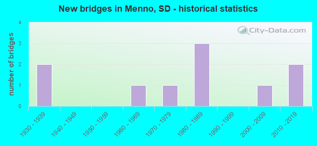
- New bridges - historical statistics
- 21930-1939
- 11960-1969
- 11970-1979
- 31980-1989
- 12000-2009
- 22010-2019

- Reconstructed bridges - Historical Statistics
- 11970-1979
- 11980-1989

- Bridge Condition - Deck
- 71.4%Good
- 28.6%Fair

- Bridge Condition - Superstructure
- 14.3%Very good
- 28.6%Good
- 28.6%Satisfactory
- 28.6%Fair

- Bridge Condition - Substructure
- 14.3%Very good
- 28.6%Satisfactory
- 14.3%Fair
- 42.9%Poor

- Bridge Condition - Channel
- 50.0%Very good
- 30.0%Good
- 20.0%Satisfactory

- Bridge Condition - Culverts
- 33.3%Very good
- 33.3%Good
- 33.3%Satisfactory
Find on map >> Show street view
Structure Number: 1208508, Location: GREGORY - CHARLES MIX CO (Lat: 43.389658, Lng: -99.122658), Route carried "on" structure: State highway 44, Year Built: 1966, Status: Open, Structure Length: 172.38m (565.55ft), Average Daily Traffic: 928 (year 2021), Truck Traffic: 9%, Average Future Daily Traffic: 1,282 (year 2041), Design Load: HS 20, Features Intersected: MO. RV (FRANCIS CASE LK)
Minimum Vertical Clearance: 30+ m (98+ ft), Kilometerpoint: 469.269, Lanes on structure: 2, Base Highway Network: Yes, Owner: State Highway Agency, Approaching Roadway Width: 12.8m (42.0ft), Navigation Control: Yes ( Vertical Clearance: 9.0m (29.5ft), Horizontal Clearance: 69.0m (226.4ft)), Material/Design: Steel continuous, Design/Construction: Girder and Floorbeam System, Number Of Spans In Main Unit: 28, Length of Maximum Span: 76.2m (250.0ft), Curb-To-Curb Width: 8.5m (27.9ft), Out-to-Out Width: 9.2m (30.2ft)
Condition: Deck: Fair, Superstructure: Fair, Substructure: Fair, Channel: Very good, Operating Rating: 50.2 metric tons, Method Used To Determine Operating Rating: Load Factor (LF), Inventory Rating: 30.0 metric tons, Method Used To Determine Inventory Rating: Load Factor (LF), Structural Evaluation: Somewhat better than minimum adequacy, Deck Geometry: Somewhat better than minimum adequacy, Waterway Adequacy: Superior to present desirable criteria, Approach Roadway Alignment: Equal to present desirable criteria, Designated Inspection Frequency: Every 12 months, Critical Feature Inspection Frequency: Every 12 months, Underwater Inspection Frequency: Every 60 months, Inspection Date: May 2021, Critical Feature Inspection Date: May 2021, Underwater Inspection Date: September 2017, Deck Structure Type: Concrete Cast-file-Place, Wearing Surface/Protective System: Wearing Surface: Epoxy Overlay, Membrane: Epoxy
Find on map >> Show street view
Structure Number: 3425916, Location: 2.0N,1.1W OF MENNO (Lat: 43.270269, Lng: -97.599878), Route carried "on" structure: County highway , Year Built: 2000, Status: Open, Structure Length: 0.70m (2.30ft), Average Daily Traffic: 10 (year 2019), Truck Traffic: 2%, Average Future Daily Traffic: 10 (year 2032), Features Intersected: CK, Facility Carried by Structure: 42990 284TH ST
Minimum Vertical Clearance: 30+ m (98+ ft), Kilometerpoint: 0.000, Lanes on structure: 2, Owner: County Highway Agency, Approaching Roadway Width: 6.4m (21.0ft), Skew: 1 degrees, Material/Design: Steel, Design/Construction: Culvert, Number Of Spans In Main Unit: 2, Length of Maximum Span: 3.1m (10.2ft)
Condition: Channel: Good, Culverts: Good, Operating Rating: 32.7 metric tons, Method Used To Determine Operating Rating: Field evaluation and documented engineering judgment, Inventory Rating: 24.5 metric tons, Method Used To Determine Inventory Rating: Field evaluation and documented engineering judgment, Structural Evaluation: Equal to present minimum criteria, Waterway Adequacy: Better than present minimum criteria, Approach Roadway Alignment: Equal to present minimum criteria, Designated Inspection Frequency: Every 24 months, Inspection Date: June 2020
Find on map >> Show street view
Structure Number: 3425919, Location: 1.0S,1.1W OF MENNO (Lat: 43.226556, Lng: -97.599933), Route carried "on" structure: County highway , Year Built: 1980, Status: Open, Structure Length: 0.78m (2.56ft), Average Daily Traffic: 25 (year 2019), Truck Traffic: 2%, Average Future Daily Traffic: 25 (year 2032), Design Load: HS 20, Features Intersected: CK, Facility Carried by Structure: 42990 287 ST.
Minimum Vertical Clearance: 30+ m (98+ ft), Kilometerpoint: 0.000, Lanes on structure: 2, Owner: County Highway Agency, Approaching Roadway Width: 7.0m (23.0ft), Material/Design: Prestressed concrete, Design/Construction: Tee Beam, Number Of Spans In Main Unit: 1, Length of Maximum Span: 7.5m (24.6ft), Curb-To-Curb Width: 7.9m (25.9ft), Out-to-Out Width: 8.2m (26.9ft)
Condition: Deck: Good, Superstructure: Good, Substructure: Satisfactory, Channel: Very good, Operating Rating: 32.7 metric tons, Method Used To Determine Operating Rating: Field evaluation and documented engineering judgment, Inventory Rating: 24.5 metric tons, Method Used To Determine Inventory Rating: Field evaluation and documented engineering judgment, Structural Evaluation: Equal to present minimum criteria, Deck Geometry: Equal to present minimum criteria, Waterway Adequacy: Equal to present desirable criteria, Approach Roadway Alignment: Equal to present desirable criteria, Length Of Structure Improvement: 3.96m (12.99ft), Designated Inspection Frequency: Every 24 months, Inspection Date: June 2020, Bridge Improvement Cost: $17,000, Roadway Improvement Cost: $5,000, Total Project Cost: $25,000 ( Estimate for 2014), Deck Structure Type: Concrete Precast Panels, Wearing Surface/Protective System: Wearing Surface: Monolithic Concrete
Find on map >> Show street view
Structure Number: 3426715, Location: 3.0N 0.3W OF MENNO (Lat: 43.284769, Lng: -97.587033), Route carried "on" structure: County highway , Year Built: 2017, Status: Open, Structure Length: 0.84m (2.76ft), Average Daily Traffic: 20 (year 2019), Truck Traffic: 2%, Average Future Daily Traffic: 20 (year 2032), Features Intersected: FURLONG CK, Facility Carried by Structure: 43070 283 ST
Minimum Vertical Clearance: 30+ m (98+ ft), Kilometerpoint: 0.000, Lanes on structure: 2, Owner: County Highway Agency, Approaching Roadway Width: 6.7m (22.0ft), Skew: 2 degrees, Material/Design: Steel, Design/Construction: Culvert, Number Of Spans In Main Unit: 2, Length of Maximum Span: 3.8m (12.5ft)
Condition: Channel: Good, Culverts: Satisfactory, Structural Evaluation: Equal to present minimum criteria, Waterway Adequacy: Better than present minimum criteria, Approach Roadway Alignment: Equal to present minimum criteria, Designated Inspection Frequency: Every 24 months, Inspection Date: June 2020
Find on map >> Show street view
Structure Number: 34280142, Location: 3.8N,1.0E OF MENNO (Lat: 43.294936, Lng: -97.559200), Route carried "on" structure: County highway , Year Built: 1981, Status: Posted for load, Structure Length: 0.95m (3.12ft), Average Daily Traffic: 15 (year 2019), Truck Traffic: 2%, Average Future Daily Traffic: 15 (year 2032), Features Intersected: CK, Facility Carried by Structure: 28220 432 AVE.
Minimum Vertical Clearance: 30+ m (98+ ft), Kilometerpoint: 0.000, Lanes on structure: 2, Owner: County Highway Agency, Approaching Roadway Width: 5.5m (18.0ft), Material/Design: Steel, Design/Construction: Stringer/Multi-beam, Number Of Spans In Main Unit: 1, Length of Maximum Span: 8.8m (28.9ft), Curb-To-Curb Width: 7.0m (23.0ft), Out-to-Out Width: 7.3m (24.0ft)
Condition: Deck: Good, Superstructure: Satisfactory, Substructure: Poor, Channel: Good, Operating Rating: 29.8 metric tons, Method Used To Determine Operating Rating: Load Factor (LF), Inventory Rating: 17.8 metric tons, Method Used To Determine Inventory Rating: Load Factor (LF), Structural Evaluation: Meets minimum limits, Deck Geometry: Somewhat better than minimum adequacy, Waterway Adequacy: Equal to present desirable criteria, Approach Roadway Alignment: Equal to present desirable criteria, Bridge Posting: Required (Relationship of Operating Rating to Maximum Legal Load: 20.0 - 29.9% below), Length Of Structure Improvement: 1.52m (4.99ft), Designated Inspection Frequency: Every 24 months, Inspection Date: June 2020, Bridge Improvement Cost: $188,000, Roadway Improvement Cost: $21,000, Total Project Cost: $350,000 ( Estimate for 2014), Deck Structure Type: Wood or Timber, Wearing Surface/Protective System: Wearing Surface: Gravel
Find on map >> Show street view
Structure Number: 342892, Location: 2 S & 1.9 E MENNO (Lat: 43.212100, Lng: -97.540025), Route carried "on" structure: County highway , Year Built: 1930, Year Reconstructed: 1978, Status: Open, Structure Length: 0.93m (3.05ft), Average Daily Traffic: 25 (year 2019), Truck Traffic: 2%, Average Future Daily Traffic: 25 (year 2032), Features Intersected: CK, Facility Carried by Structure: 43290 288 ST.
Minimum Vertical Clearance: 30+ m (98+ ft), Kilometerpoint: 0.000, Lanes on structure: 2, Owner: County Highway Agency, Approaching Roadway Width: 6.1m (20.0ft), Material/Design: Concrete, Design/Construction: Channel Beam, Number Of Spans In Main Unit: 1, Length of Maximum Span: 9.0m (29.5ft), Curb-To-Curb Width: 7.3m (24.0ft), Out-to-Out Width: 7.7m (25.3ft)
Condition: Deck: Good, Superstructure: Fair, Substructure: Poor, Channel: Very good, Operating Rating: 32.7 metric tons, Method Used To Determine Operating Rating: Field evaluation and documented engineering judgment, Inventory Rating: 24.5 metric tons, Method Used To Determine Inventory Rating: Field evaluation and documented engineering judgment, Structural Evaluation: Meets minimum limits, Deck Geometry: Equal to present minimum criteria, Waterway Adequacy: Equal to present minimum criteria, Approach Roadway Alignment: Better than present minimum criteria, Length Of Structure Improvement: 3.96m (12.99ft), Designated Inspection Frequency: Every 24 months, Inspection Date: June 2020, Bridge Improvement Cost: $17,000, Roadway Improvement Cost: $5,000, Total Project Cost: $25,000 ( Estimate for 2014), Deck Structure Type: Concrete Precast Panels, Wearing Surface/Protective System: Wearing Surface: Gravel
Find on map >> Show street view
Structure Number: 3428921, Location: 3 S & 1.9 E MENNO (Lat: 43.197647, Lng: -97.539892), Route carried "on" structure: County highway , Year Built: 1978, Status: Open, Structure Length: 1.08m (3.54ft), Average Daily Traffic: 20 (year 2019), Truck Traffic: 2%, Average Future Daily Traffic: 20 (year 2032), Features Intersected: CK, Facility Carried by Structure: 43290 289 ST.
Minimum Vertical Clearance: 30+ m (98+ ft), Kilometerpoint: 0.000, Lanes on structure: 2, Owner: County Highway Agency, Approaching Roadway Width: 9.0m (29.5ft), Material/Design: Prestressed concrete, Design/Construction: Tee Beam, Number Of Spans In Main Unit: 1, Length of Maximum Span: 10.5m (34.4ft), Curb-To-Curb Width: 9.1m (29.9ft), Out-to-Out Width: 9.3m (30.5ft)
Condition: Deck: Good, Superstructure: Very good, Substructure: Very good, Channel: Satisfactory, Operating Rating: 32.7 metric tons, Method Used To Determine Operating Rating: Field evaluation and documented engineering judgment, Inventory Rating: 24.5 metric tons, Method Used To Determine Inventory Rating: Field evaluation and documented engineering judgment, Structural Evaluation: Equal to present minimum criteria, Deck Geometry: Better than present minimum criteria, Waterway Adequacy: Equal to present minimum criteria, Approach Roadway Alignment: Equal to present desirable criteria, Length Of Structure Improvement: 1.83m (6.00ft), Designated Inspection Frequency: Every 24 months, Inspection Date: June 2020, Bridge Improvement Cost: $226,000, Roadway Improvement Cost: $24,000, Total Project Cost: $401,000 ( Estimate for 2014), Deck Structure Type: Concrete Precast Panels, Wearing Surface/Protective System: Wearing Surface: Monolithic Concrete
Find on map >> Show street view
Structure Number: 34290196, Location: 1.6S,2.0E OF MENNO (Lat: 43.218094, Lng: -97.538381), Route carried "on" structure: County highway , Year Built: 1935, Year Reconstructed: 1989, Status: Posted for load, Structure Length: 0.93m (3.05ft), Average Daily Traffic: 35 (year 2019), Truck Traffic: 2%, Average Future Daily Traffic: 35 (year 2032), Features Intersected: CK, Facility Carried by Structure: 28760 433 AVE.
Minimum Vertical Clearance: 30+ m (98+ ft), Kilometerpoint: 0.000, Lanes on structure: 2, Owner: County Highway Agency, Approaching Roadway Width: 6.7m (22.0ft), Material/Design: Steel, Design/Construction: Stringer/Multi-beam, Number Of Spans In Main Unit: 1, Length of Maximum Span: 8.8m (28.9ft), Curb-To-Curb Width: 8.1m (26.6ft), Out-to-Out Width: 8.3m (27.2ft)
Condition: Deck: Fair, Superstructure: Good, Substructure: Poor, Channel: Satisfactory, Operating Rating: 15.6 metric tons, Method Used To Determine Operating Rating: Load and Resistance Factor (LRFR), Inventory Rating: 12.1 metric tons, Method Used To Determine Inventory Rating: Load and Resistance Factor (LRFR), Structural Evaluation: Meets minimum limits, Deck Geometry: Equal to present minimum criteria, Waterway Adequacy: Equal to present desirable criteria, Approach Roadway Alignment: Equal to present desirable criteria, Bridge Posting: Required (Relationship of Operating Rating to Maximum Legal Load: 30.0 - 39.9% below), Length Of Structure Improvement: 1.52m (4.99ft), Designated Inspection Frequency: Every 24 months, Inspection Date: June 2020, Bridge Improvement Cost: $188,000, Roadway Improvement Cost: $21,000, Total Project Cost: $350,000 ( Estimate for 2014), Deck Structure Type: Corrugated Steel, Wearing Surface/Protective System: Wearing Surface: Gravel
Find on map >> Show street view
Structure Number: 3429515, Location: 3.0N,2.5E OF MENNO (Lat: 43.284667, Lng: -97.528475), Route carried "on" structure: County highway , Year Built: 1982, Status: Open, Structure Length: 0.86m (2.82ft), Average Daily Traffic: 15 (year 2019), Truck Traffic: 2%, Average Future Daily Traffic: 15 (year 2032), Features Intersected: CK, Facility Carried by Structure: 43350 283 ST.
Minimum Vertical Clearance: 30+ m (98+ ft), Kilometerpoint: 0.000, Lanes on structure: 2, Owner: County Highway Agency, Approaching Roadway Width: 6.4m (21.0ft), Material/Design: Steel, Design/Construction: Stringer/Multi-beam, Number Of Spans In Main Unit: 1, Length of Maximum Span: 7.8m (25.6ft), Curb-To-Curb Width: 7.1m (23.3ft), Out-to-Out Width: 7.4m (24.3ft)
Condition: Deck: Good, Superstructure: Satisfactory, Substructure: Satisfactory, Channel: Very good, Operating Rating: 41.8 metric tons, Method Used To Determine Operating Rating: Load Factor (LF), Inventory Rating: 25.0 metric tons, Method Used To Determine Inventory Rating: Load Factor (LF), Structural Evaluation: Equal to present minimum criteria, Deck Geometry: Somewhat better than minimum adequacy, Waterway Adequacy: Equal to present desirable criteria, Approach Roadway Alignment: Equal to present desirable criteria, Length Of Structure Improvement: 1.52m (4.99ft), Designated Inspection Frequency: Every 24 months, Inspection Date: June 2020, Bridge Improvement Cost: $188,000, Roadway Improvement Cost: $21,000, Total Project Cost: $350,000 ( Estimate for 2014), Deck Structure Type: Wood or Timber, Wearing Surface/Protective System: Wearing Surface: Gravel
Find on map >> Show street view
Structure Number: 37050082, Location: 13W WESSINGTON SPRINGS (Lat: 44.077006, Lng: -98.827633), Route carried "on" structure: County highway , Year Built: 2015, Status: Open, Structure Length: 0.61m (2.00ft), Average Daily Traffic: 57 (year 2019), Truck Traffic: 3%, Average Future Daily Traffic: 57 (year 2032), Features Intersected: CK, Facility Carried by Structure: 368 AVENUE
Minimum Vertical Clearance: 30+ m (98+ ft), Kilometerpoint: 0.000, Lanes on structure: 2, Owner: County Highway Agency, Approaching Roadway Width: 6.7m (22.0ft), Material/Design: Steel, Design/Construction: Culvert, Number Of Spans In Main Unit: 3, Length of Maximum Span: 1.5m (4.9ft)
Condition: Channel: Very good, Culverts: Very good, Structural Evaluation: Equal to present desirable criteria, Waterway Adequacy: Better than present minimum criteria, Approach Roadway Alignment: Equal to present desirable criteria, Designated Inspection Frequency: Every 24 months, Inspection Date: September 2020