Bridge Statistics for Menominee, Michigan (MI)
Condition, Traffic, Stress, Structural Evaluation, Project Costs
- National Bridge Inventory (NBI) Statistics
- 12Number of bridges
- 246ft / 75.4mTotal length
- $1,030,000Total costs
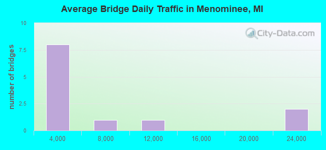
- 60,604Total average daily traffic
- 2,219Total average daily truck traffic
- 76,932Total future (year 2015) average daily traffic
- National Bridge Inventory (NBI) Registered Bridges for Menominee
- No street view available for this location
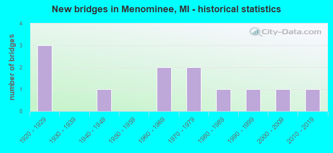
- New bridges - historical statistics
- 31920-1929
- 11940-1949
- 21960-1969
- 21970-1979
- 11980-1989
- 11990-1999
- 12000-2009
- 12010-2019
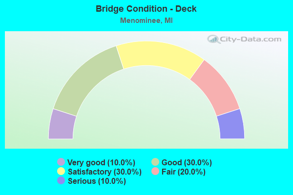
- Bridge Condition - Deck
- 10.0%Very good
- 30.0%Good
- 30.0%Satisfactory
- 20.0%Fair
- 10.0%Serious
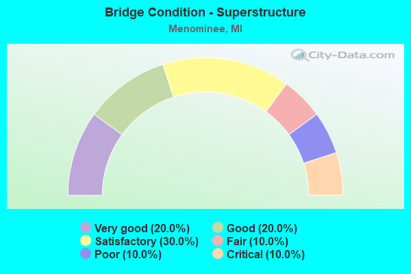
- Bridge Condition - Superstructure
- 20.0%Very good
- 20.0%Good
- 30.0%Satisfactory
- 10.0%Fair
- 10.0%Poor
- 10.0%Critical
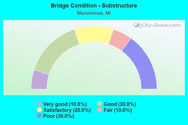
- Bridge Condition - Substructure
- 10.0%Very good
- 30.0%Good
- 20.0%Satisfactory
- 10.0%Fair
- 30.0%Poor
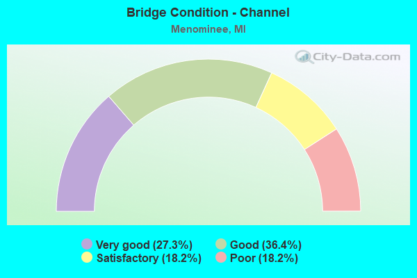
- Bridge Condition - Channel
- 27.3%Very good
- 36.4%Good
- 18.2%Satisfactory
- 18.2%Poor
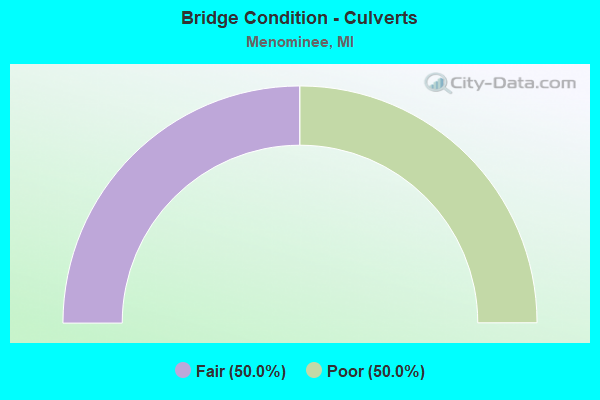
- Bridge Condition - Culverts
- 50.0%Fair
- 50.0%Poor
Find on map >> Show street view
Structure Number: 688, Location: 3 MI N 3.5 MI W OF CRUMP (Lat: 43.801014, Lng: -84.156611), Route carried "on" structure: County highway 960, Year Built: 1942, Status: Closed, Structure Length: 1.37m (4.49ft), Average Daily Traffic: 172 (year 2000), Truck Traffic: 2%, Average Future Daily Traffic: 206 (year 2020), Design Load: HS 20, Features Intersected: N BR KAWKAWLIN RIVER, Facility Carried by Structure: ERICKSON ROAD
Minimum Vertical Clearance: 30.48m (100.00ft), Kilometerpoint: 0.930, Lanes on structure: 2, Owner: County Highway Agency, Approaching Roadway Width: 7.3m (24.0ft), Material/Design: Steel, Design/Construction: Stringer/Multi-beam, Number Of Spans In Main Unit: 1, Length of Maximum Span: 12.8m (42.0ft), Curb-To-Curb Width: 8.8m (28.9ft), Out-to-Out Width: 9.4m (30.8ft)
Condition: Deck: Serious, Superstructure: Critical, Substructure: Poor, Channel: Poor, Operating Rating: 2.9 metric tons, Method Used To Determine Operating Rating: Load Factor (LF), Inventory Rating: 1.7 metric tons, Method Used To Determine Inventory Rating: Load Factor (LF), Deck Geometry: Equal to present minimum criteria, Waterway Adequacy: Equal to present minimum criteria, Approach Roadway Alignment: Somewhat better than minimum adequacy, Bridge Posting: Required (Relationship of Operating Rating to Maximum Legal Load: > 39.9% below), Length Of Structure Improvement: 2.00m (6.56ft), Designated Inspection Frequency: Every 24 months, Inspection Date: May 2021, Bridge Improvement Cost: $335,000, Roadway Improvement Cost: $70,000, Total Project Cost: $425,000, Deck Structure Type: Concrete Cast-file-Place, Wearing Surface/Protective System: Wearing Surface: Bituminous
Find on map >> Show street view
Structure Number: 6787, Location: WISCONSIN STATE LINE (Lat: 45.103928, Lng: -87.625419), Route carried "on" structure: US 41, Year Built: 2005, Status: Open, Structure Length: 26.47m (86.84ft), Average Daily Traffic: 20,760 (year 2007), Truck Traffic: 2%, Average Future Daily Traffic: 27,473 (year 2018), Design Load: HS 20, Features Intersected: MENOMINEE RIVER
Minimum Vertical Clearance: 30.48m (100.00ft), Kilometerpoint: 0.122, Lanes on structure: 4, Base Highway Network: Yes (Inventory Route: 132, Subroute: 8), Owner: State Highway Agency, Approaching Roadway Width: 17.7m (58.1ft), Skew: 1 degrees, Material/Design: Prestressed concrete, Design/Construction: Stringer/Multi-beam, Number Of Spans In Main Unit: 6, Length of Maximum Span: 47.9m (157.2ft), Curb or Sidewalk Widths: Left: 2.1m (6.9ft), Right: 2.1m (6.9ft), Curb-To-Curb Width: 17.7m (58.1ft), Out-to-Out Width: 22.6m (74.1ft)
Condition: Deck: Good, Superstructure: Good, Substructure: Good, Channel: Very good, Operating Rating: 89.9 metric tons, Method Used To Determine Operating Rating: Load Factor (LF), Inventory Rating: 53.8 metric tons, Method Used To Determine Inventory Rating: Load Factor (LF), Structural Evaluation: Better than present minimum criteria, Deck Geometry: Somewhat better than minimum adequacy, Waterway Adequacy: Better than present minimum criteria, Approach Roadway Alignment: Equal to present minimum criteria, Designated Inspection Frequency: Every 24 months, Underwater Inspection Frequency: Every 60 months, Inspection Date: August 2021, Underwater Inspection Date: July 2021, Deck Structure Type: Concrete Cast-file-Place, Wearing Surface/Protective System: Wearing Surface: Monolithic Concrete, Deck Protection: Epoxy Coated Reinforcing
Find on map >> Show street view
Structure Number: 6789, Location: IN MENOMINEE (Lat: 45.106139, Lng: -87.622575), Route carried "on" structure: US 41, Year Built: 1998, Status: Open, Structure Length: 2.21m (7.25ft), Average Daily Traffic: 20,760 (year 2007), Truck Traffic: 2%, Average Future Daily Traffic: 27,473 (year 2018), Design Load: HS 25 or greater, Features Intersected: C&NW & E&LS RR
Minimum Vertical Clearance: 30.48m (100.00ft), Kilometerpoint: 0.455, Lanes on structure: 2, Base Highway Network: Yes (Inventory Route: 132, Subroute: 8), Owner: State Highway Agency, Approaching Roadway Width: 15.5m (50.9ft), Skew: 1 degrees, Material/Design: Prestressed concrete, Design/Construction: Box Beam or Girders - Single/Spread, Number Of Spans In Main Unit: 1, Length of Maximum Span: 20.9m (68.6ft), Curb or Sidewalk Widths: Left: 2.1m (6.9ft), Right: 2.1m (6.9ft), Curb-To-Curb Width: 15.5m (50.9ft), Out-to-Out Width: 20.5m (67.3ft)
Condition: Deck: Good, Superstructure: Very good, Substructure: Good, Operating Rating: 91.8 metric tons, Method Used To Determine Operating Rating: Load Factor (LF), Inventory Rating: 55.0 metric tons, Method Used To Determine Inventory Rating: Load Factor (LF), Structural Evaluation: Better than present minimum criteria, Deck Geometry: Superior to present desirable criteria, Underclear: Equal to present minimum criteria, Approach Roadway Alignment: Better than present minimum criteria, Designated Inspection Frequency: Every 24 months, Inspection Date: August 2021, Deck Structure Type: Concrete Cast-file-Place, Wearing Surface/Protective System: Wearing Surface: Monolithic Concrete, Deck Protection: Epoxy Coated Reinforcing
Find on map >> Show street view
Structure Number: 6825, Location: 1.7 MI W OF MENOMINEE (Lat: 45.135728, Lng: -87.667161), Route carried "on" structure: County highway 5519, Year Built: 1969, Status: Open, Structure Length: 1.52m (4.99ft), Average Daily Traffic: 650 (year 0000), Average Future Daily Traffic: 835 (year 2019), Design Load: H 20, Features Intersected: LITTLE RIVER, Facility Carried by Structure: RIVER ROAD
Minimum Vertical Clearance: 30.48m (100.00ft), Kilometerpoint: 0.317, Lanes on structure: 2, Owner: County Highway Agency, Approaching Roadway Width: 11.0m (36.1ft), Material/Design: Prestressed concrete, Design/Construction: Box Beam or Girders - Multiple, Number Of Spans In Main Unit: 1, Length of Maximum Span: 14.9m (48.9ft), Curb-To-Curb Width: 11.0m (36.1ft), Out-to-Out Width: 11.0m (36.1ft)
Condition: Deck: Good, Superstructure: Good, Substructure: Good, Channel: Very good, Operating Rating: 70.6 metric tons, Method Used To Determine Operating Rating: Load Factor (LF) rating reported by rating factor (RF) method using MS18 loading, Inventory Rating: 42.4 metric tons, Method Used To Determine Inventory Rating: Load Factor (LF) rating reported by rating factor (RF) method using MS18 loading, Structural Evaluation: Better than present minimum criteria, Deck Geometry: Better than present minimum criteria, Waterway Adequacy: Equal to present desirable criteria, Approach Roadway Alignment: Equal to present desirable criteria, Designated Inspection Frequency: Every 24 months, Inspection Date: June 2021, Deck Structure Type: Concrete Precast Panels, Wearing Surface/Protective System: Wearing Surface: Bituminous
Find on map >> Show street view
Structure Number: 6826, Location: 1.7 MI W OF MENOMINEE (Lat: 45.145081, Lng: -87.665378), Route carried "on" structure: County highway 5523, Year Built: 1962, Status: Open, Structure Length: 1.70m (5.58ft), Average Daily Traffic: 1,283 (year 1998), Truck Traffic: 3%, Average Future Daily Traffic: 1,150 (year 2019), Design Load: HS 20, Features Intersected: LITTLE RIVER, Facility Carried by Structure: ROUTE 581
Minimum Vertical Clearance: 30.48m (100.00ft), Kilometerpoint: 0.784, Lanes on structure: 2, Owner: County Highway Agency, Approaching Roadway Width: 9.1m (29.9ft), Skew: 3 degrees, Material/Design: Prestressed concrete, Design/Construction: Box Beam or Girders - Multiple, Number Of Spans In Main Unit: 1, Length of Maximum Span: 16.7m (54.8ft), Curb-To-Curb Width: 9.1m (29.9ft), Out-to-Out Width: 9.2m (30.2ft)
Condition: Deck: Satisfactory, Superstructure: Satisfactory, Substructure: Fair, Channel: Good, Operating Rating: 43.4 metric tons, Method Used To Determine Operating Rating: Field evaluation and documented engineering judgment, Inventory Rating: 32.7 metric tons, Method Used To Determine Inventory Rating: Field evaluation and documented engineering judgment, Structural Evaluation: Somewhat better than minimum adequacy, Deck Geometry: Somewhat better than minimum adequacy, Waterway Adequacy: Equal to present desirable criteria, Approach Roadway Alignment: Equal to present desirable criteria, Length Of Structure Improvement: 1.71m (5.61ft), Designated Inspection Frequency: Every 12 months, Inspection Date: June 2021, Bridge Improvement Cost: $35,000, Roadway Improvement Cost: $4,000, Total Project Cost: $55,000, Deck Structure Type: Concrete Cast-file-Place, Wearing Surface/Protective System: Wearing Surface: Monolithic Concrete
Find on map >> Show street view
Structure Number: 6827, Location: 2.5 MI W OF BIRCH CREEK (Lat: 45.204761, Lng: -87.659072), Route carried "on" structure: County highway 5523, Year Built: 1920, Year Reconstructed: 1950, Status: Posted for load, Structure Length: 1.25m (4.10ft), Average Daily Traffic: 216 (year 1998), Truck Traffic: 2%, Average Future Daily Traffic: 350 (year 2019), Features Intersected: LITTLE RIVER, Facility Carried by Structure: ROUTE 577
Minimum Vertical Clearance: 30.48m (100.00ft), Kilometerpoint: 10.662, Lanes on structure: 2, Owner: County Highway Agency, Approaching Roadway Width: 9.1m (29.9ft), Material/Design: Concrete, Design/Construction: Culvert, Number Of Spans In Main Unit: 4, Length of Maximum Span: 2.7m (8.9ft), Curb-To-Curb Width: 9.1m (29.9ft), Out-to-Out Width: 9.1m (29.9ft)
Condition: Channel: Satisfactory, Culverts: Poor, Operating Rating: 26.8 metric tons, Method Used To Determine Operating Rating: Load Factor (LF), Inventory Rating: 16.1 metric tons, Method Used To Determine Inventory Rating: Load Factor (LF), Structural Evaluation: Meets minimum limits, Deck Geometry: Equal to present minimum criteria, Waterway Adequacy: Equal to present desirable criteria, Approach Roadway Alignment: Equal to present desirable criteria, Bridge Posting: Required (Relationship of Operating Rating to Maximum Legal Load: 10.0 - 19.9% below), Designated Inspection Frequency: Every 12 months, Inspection Date: June 2021
Find on map >> Show street view
Structure Number: 6859, Location: 3.5 MI N MENOMINEE (Lat: 45.167181, Lng: -87.661861), Route carried "on" structure: County highway , Year Built: 1981, Status: Open, Structure Length: 1.79m (5.87ft), Average Daily Traffic: 292 (year 1998), Average Future Daily Traffic: 85 (year 2019), Design Load: HS 20, Features Intersected: LITTLE RIVER, Facility Carried by Structure: 3.5 MI ROAD
Minimum Vertical Clearance: 30.48m (100.00ft), Kilometerpoint: 3.352, Lanes on structure: 2, Owner: County Highway Agency, Approaching Roadway Width: 10.1m (33.1ft), Material/Design: Steel, Design/Construction: Culvert, Number Of Spans In Main Unit: 4, Length of Maximum Span: 3.6m (11.8ft)
Condition: Channel: Poor, Culverts: Fair, Operating Rating: 54.0 metric tons, Method Used To Determine Operating Rating: Load Factor (LF), Inventory Rating: 19.4 metric tons, Method Used To Determine Inventory Rating: Load Factor (LF), Structural Evaluation: Somewhat better than minimum adequacy, Waterway Adequacy: Better than present minimum criteria, Approach Roadway Alignment: Equal to present desirable criteria, Designated Inspection Frequency: Every 24 months, Inspection Date: June 2021
Find on map >> Show street view
Structure Number: 686, Location: 5 MI. NW OF MENOMINEE (Lat: 45.188925, Lng: -87.662856), Route carried "on" structure: County highway , Year Built: 2017, Status: Open, Structure Length: 1.58m (5.18ft), Average Daily Traffic: 50 (year 2015), Truck Traffic: 3%, Average Future Daily Traffic: 65 (year 2035), Design Load: Greater than HL93, Features Intersected: LITTLE RIVER, Facility Carried by Structure: 5 MILE ROAD
Minimum Vertical Clearance: 30.48m (100.00ft), Kilometerpoint: 1.996, Lanes on structure: 2, Owner: County Highway Agency, Approaching Roadway Width: 8.6m (28.2ft), Material/Design: Prestressed concrete, Design/Construction: Box Beam or Girders - Multiple, Number Of Spans In Main Unit: 1, Length of Maximum Span: 15.5m (50.9ft), Curb-To-Curb Width: 8.6m (28.2ft), Out-to-Out Width: 9.5m (31.2ft)
Condition: Deck: Very good, Superstructure: Very good, Substructure: Very good, Channel: Good, Operating Rating: 60.3 metric tons, Method Used To Determine Operating Rating: Assigned ratings based on Load and Resistance Factor Design (LRFD) reported by rating factor (RF) using HL93 loadings, Inventory Rating: 46.7 metric tons, Method Used To Determine Inventory Rating: Assigned ratings based on Load and Resistance Factor Design (LRFD) reported by rating factor (RF) using HL93 loadings, Structural Evaluation: Equal to present desirable criteria, Waterway Adequacy: Better than present minimum criteria, Approach Roadway Alignment: Equal to present desirable criteria, Length Of Structure Improvement: 1.52m (4.99ft), Designated Inspection Frequency: Every 24 months, Inspection Date: June 2021, Bridge Improvement Cost: $95,000, Roadway Improvement Cost: $10,000, Total Project Cost: $150,000, Deck Structure Type: Concrete Cast-file-Place, Wearing Surface/Protective System: Wearing Surface: Monolithic Concrete, Deck Protection: Epoxy Coated Reinforcing
Find on map >> Show street view
Structure Number: 6861, Location: 2 MI. NW OF MENOMINEE (Lat: 45.152411, Lng: -87.661811), Route carried "on" structure: County highway , Year Built: 1928, Status: Posted for load, Structure Length: 1.52m (4.99ft), Average Daily Traffic: 292 (year 1998), Truck Traffic: 2%, Average Future Daily Traffic: 130 (year 2019), Design Load: H 20, Features Intersected: LITTLE RIVER, Facility Carried by Structure: DEERPARK DRIVE
Minimum Vertical Clearance: 30.48m (100.00ft), Kilometerpoint: 1.474, Lanes on structure: 2, Owner: County Highway Agency, Approaching Roadway Width: 6.1m (20.0ft), Material/Design: Steel, Design/Construction: Stringer/Multi-beam, Number Of Spans In Main Unit: 1, Number Of Approach Spans: 1, Length of Maximum Span: 10.6m (34.8ft), Curb-To-Curb Width: 4.9m (16.1ft), Out-to-Out Width: 4.9m (16.1ft)
Condition: Deck: Fair, Superstructure: Poor, Substructure: Poor, Channel: Satisfactory, Operating Rating: 49.2 metric tons, Method Used To Determine Operating Rating: Load Factor (LF) rating reported by rating factor (RF) method using MS18 loading, Inventory Rating: 29.5 metric tons, Method Used To Determine Inventory Rating: Load Factor (LF) rating reported by rating factor (RF) method using MS18 loading, Structural Evaluation: Meets minimum limits, Waterway Adequacy: Better than present minimum criteria, Approach Roadway Alignment: High priority of corrective action, Bridge Posting: Required (Relationship of Operating Rating to Maximum Legal Load: 0.1 - 9.9% below), Designated Inspection Frequency: Every 12 months, Inspection Date: June 2021, Deck Structure Type: Concrete Cast-file-Place, Wearing Surface/Protective System: Wearing Surface: Bituminous
Find on map >> Show street view
Structure Number: 6862, Location: 5 MI. N OFMENOMINEE (Lat: 45.213928, Lng: -87.632925), Route carried "on" structure: County highway , Year Built: 1928, Status: Posted for load, Structure Length: 1.22m (4.00ft), Average Daily Traffic: 39 (year 1998), Average Future Daily Traffic: 65 (year 2019), Design Load: H 20, Features Intersected: LITTLE RIVER, Facility Carried by Structure: 6.25 ROAD
Minimum Vertical Clearance: 30.48m (100.00ft), Kilometerpoint: 2.213, Lanes on structure: 2, Owner: County Highway Agency, Approaching Roadway Width: 4.9m (16.1ft), Material/Design: Steel, Design/Construction: Stringer/Multi-beam, Number Of Spans In Main Unit: 1, Length of Maximum Span: 11.5m (37.7ft), Curb-To-Curb Width: 4.9m (16.1ft), Out-to-Out Width: 4.9m (16.1ft)
Condition: Deck: Fair, Superstructure: Fair, Substructure: Satisfactory, Channel: Good, Operating Rating: 19.4 metric tons, Method Used To Determine Operating Rating: Load Factor (LF) rating reported by rating factor (RF) method using MS18 loading, Inventory Rating: 11.7 metric tons, Method Used To Determine Inventory Rating: Load Factor (LF) rating reported by rating factor (RF) method using MS18 loading, Structural Evaluation: Meets minimum limits, Waterway Adequacy: Meets minimum limits, Approach Roadway Alignment: Better than present minimum criteria, Bridge Posting: Required (Relationship of Operating Rating to Maximum Legal Load: 30.0 - 39.9% below), Designated Inspection Frequency: Every 24 months, Inspection Date: June 2021, Deck Structure Type: Concrete Cast-file-Place, Wearing Surface/Protective System: Wearing Surface: Monolithic Concrete
Find on map >> Show street view
Structure Number: 6879, Location: IN MENOMINEE CITY (Lat: 45.106494, Lng: -87.635478), Route carried "on" structure: City street 26, Year Built: 1976, Status: Open, Structure Length: 17.22m (56.50ft), Average Daily Traffic: 8,450 (year 1997), Truck Traffic: 5%, Average Future Daily Traffic: 10,000 (year 2015), Design Load: HS 20+Mod, Features Intersected: MENOMINEE RIVER
Minimum Vertical Clearance: 30.48m (100.00ft), Kilometerpoint: 0.182, Lanes on structure: 2, Owner: City or Municipal Highway Agency, Approaching Roadway Width: 11.0m (36.1ft), Material/Design: Prestressed concrete, Design/Construction: Stringer/Multi-beam, Number Of Spans In Main Unit: 5, Length of Maximum Span: 34.1m (111.9ft), Curb or Sidewalk Widths: Left: 0.1m (0.3ft), Right: 2.7m (8.9ft), Curb-To-Curb Width: 10.4m (34.1ft), Out-to-Out Width: 13.8m (45.3ft)
Condition: Deck: Satisfactory, Superstructure: Satisfactory, Substructure: Poor, Channel: Very good, Operating Rating: 73.5 metric tons, Method Used To Determine Operating Rating: Load Factor (LF) rating reported by rating factor (RF) method using MS18 loading, Inventory Rating: 27.9 metric tons, Method Used To Determine Inventory Rating: Load Factor (LF) rating reported by rating factor (RF) method using MS18 loading, Structural Evaluation: Meets minimum limits, Deck Geometry: Meets minimum limits, Waterway Adequacy: Superior to present desirable criteria, Approach Roadway Alignment: Equal to present desirable criteria, Designated Inspection Frequency: Every 24 months, Underwater Inspection Frequency: Every 60 months, Inspection Date: June 2021, Underwater Inspection Date: October 2017, Deck Structure Type: Concrete Cast-file-Place, Wearing Surface/Protective System: Wearing Surface: Monolithic Concrete
Find on map >> Show street view
Structure Number: 688, Location: IN MENOMINEE CITY (Lat: 45.096872, Lng: -87.598103), Route carried "on" structure: City street 1, Year Built: 1972, Status: Open, Structure Length: 17.56m (57.61ft), Average Daily Traffic: 7,640 (year 1997), Truck Traffic: 12%, Average Future Daily Traffic: 9,100 (year 2015), Design Load: HS 20+Mod, Features Intersected: MENOMINEE RIVER
Minimum Vertical Clearance: 30.48m (100.00ft), Kilometerpoint: 0.093, Lanes on structure: 2, Owner: City or Municipal Highway Agency, Approaching Roadway Width: 13.4m (44.0ft), Navigation Control: Yes ( Vertical Clearance: 5.4m (17.7ft), Horizontal Clearance: 12.7m (41.7ft)), Material/Design: Steel, Design/Construction: Movable - Bascule, Number Of Spans In Main Unit: 1, Number Of Approach Spans: 5, Length of Maximum Span: 43.6m (143.0ft), Curb or Sidewalk Widths: Left: 1.4m (4.6ft), Right: 1.4m (4.6ft), Curb-To-Curb Width: 9.1m (29.9ft), Out-to-Out Width: 12.7m (41.7ft)
Condition: Deck: Satisfactory, Superstructure: Satisfactory, Substructure: Satisfactory, Channel: Good, Operating Rating: 48.6 metric tons, Method Used To Determine Operating Rating: Load Factor (LF) rating reported by rating factor (RF) method using MS18 loading, Inventory Rating: 29.2 metric tons, Method Used To Determine Inventory Rating: Load Factor (LF) rating reported by rating factor (RF) method using MS18 loading, Structural Evaluation: Equal to present minimum criteria, Deck Geometry: Meets minimum limits, Waterway Adequacy: Equal to present desirable criteria, Approach Roadway Alignment: Equal to present desirable criteria, Length Of Structure Improvement: 4.02m (13.19ft), Designated Inspection Frequency: Every 24 months, Critical Feature Inspection Frequency: Every 24 months, Underwater Inspection Frequency: Every 60 months, Inspection Date: June 2021, Critical Feature Inspection Date: June 2021, Underwater Inspection Date: July 2021, Bridge Improvement Cost: $400,000, Total Project Cost: $400,000, Deck Structure Type: Concrete Cast-file-Place, Wearing Surface/Protective System: Wearing Surface: Latex Concrete