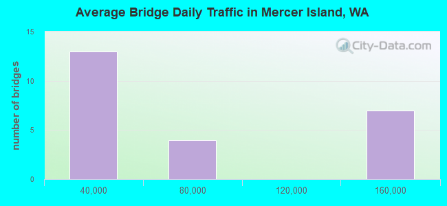
Bridge Statistics for Mercer Island, Washington (WA)
Condition, Traffic, Stress, Structural Evaluation, Project Costs
- National Bridge Inventory (NBI) Statistics
- 24Number of bridges
- 968ft / 295mTotal length
- $309,402,000Total costs
- 1,400,337Total average daily traffic
- 54,691Total average daily truck traffic
- National Bridge Inventory (NBI) Registered Bridges for Mercer Island
- No street view available for this location
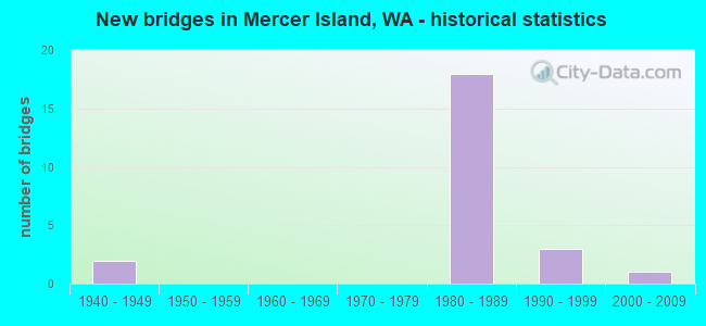
- New bridges - historical statistics
- 21940-1949
- 181980-1989
- 31990-1999
- 12000-2009
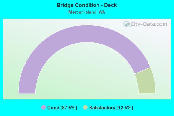
- Bridge Condition - Deck
- 87.5%Good
- 12.5%Satisfactory
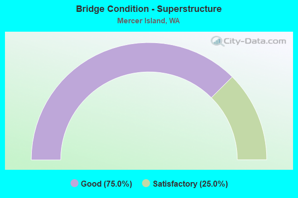
- Bridge Condition - Superstructure
- 75.0%Good
- 25.0%Satisfactory
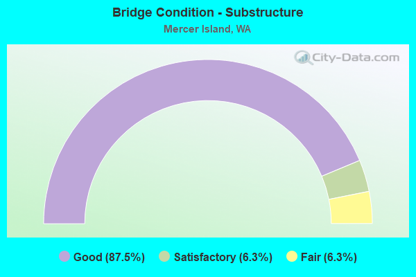
- Bridge Condition - Substructure
- 87.5%Good
- 6.3%Satisfactory
- 6.3%Fair
Find on map >> Show street view
Structure Number: KP, Location: 3.8 E JCT I-5 (Lat: 47.589258, Lng: -122.255772), Route carried "on" structure: Interstate 90, Year Built: 1940, Year Reconstructed: 1992, Status: Open, Structure Length: 27.13m (89.01ft), Average Daily Traffic: 73,775 (year 2019), Truck Traffic: 4%, Average Future Daily Traffic: 104,170 (year 2039), Design Load: HS 20+Mod, Features Intersected: LAKE WASHINGTON
Minimum Vertical Clearance: 6.30m (20.67ft), Kilometerpoint: 6.888, Lanes on structure: 4, Lanes under structure: 2, Base Highway Network: Yes, Owner: State Highway Agency, Approaching Roadway Width: 15.8m (51.8ft), Navigation Control: Yes ( Vertical Clearance: 8.8m (28.9ft), Horizontal Clearance: 59.4m (194.9ft)), Material/Design: Steel, Design/Construction: Arch - Thru, Number Of Spans In Main Unit: 1, Number Of Approach Spans: 3, Length of Maximum Span: 69.2m (227.0ft), Curb-To-Curb Width: 15.8m (51.8ft), Out-to-Out Width: 16.8m (55.1ft)
Condition: Deck: Good, Superstructure: Good, Substructure: Good, Channel: Very good, Operating Rating: 26.6 metric tons, Method Used To Determine Operating Rating: Load and Resistance Factor Rating (LRFR) rating reported by rating factor(RF) method using HL-93 loadings, Inventory Rating: 20.7 metric tons, Method Used To Determine Inventory Rating: Load and Resistance Factor Rating (LRFR) rating reported by rating factor(RF) method using HL-93 loadings, Structural Evaluation: Somewhat better than minimum adequacy, Deck Geometry: Meets minimum limits, Underclear: Equal to present minimum criteria, Waterway Adequacy: Equal to present desirable criteria, Approach Roadway Alignment: Equal to present desirable criteria, Length Of Structure Improvement: 27.13m (89.01ft), Designated Inspection Frequency: Every 24 months, Critical Feature Inspection Frequency: Every 24 months, Underwater Inspection Frequency: Every 60 months, Inspection Date: May 2021, Critical Feature Inspection Date: May 2021, Underwater Inspection Date: May 2018, Bridge Improvement Cost: $9,612,000, Roadway Improvement Cost: $1,922,000, Total Project Cost: $19,224,000 ( Estimate for 2014), Deck Structure Type: Concrete Cast-file-Place, Wearing Surface/Protective System: Wearing Surface: Latex Concrete, Deck Protection: Epoxy Coated Reinforcing
Find on map >> Show street view
Structure Number: 11490A, Location: 5.9 E JCT I-5 (Lat: 47.578217, Lng: -122.204706), Route carried "on" structure: Interstate 90, Year Built: 1981, Status: Open, Structure Length: 67.79m (222.41ft), Average Daily Traffic: 74,752 (year 2019), Truck Traffic: 4%, Average Future Daily Traffic: 105,549 (year 2039), Design Load: HS 20+Mod, Features Intersected: EAST CHANNEL-LK WASH
Minimum Vertical Clearance: 30+ m (98+ ft), Kilometerpoint: 13.647, Lanes on structure: 6, Lanes under structure: 4, Base Highway Network: Yes, Owner: State Highway Agency, Approaching Roadway Width: 24.4m (80.1ft), Skew: 9 degrees, Navigation Control: Yes ( Vertical Clearance: 16.5m (54.1ft), Horizontal Clearance: 61.0m (200.1ft)), Material/Design: Steel continuous, Design/Construction: Box Beam or Girders - Single/Spread, Number Of Spans In Main Unit: 9, Length of Maximum Span: 91.4m (299.9ft), Curb or Sidewalk Widths: Left: 2.4m (7.9ft), Right: 0.0m, Curb-To-Curb Width: 24.4m (80.1ft), Out-to-Out Width: 28.0m (91.9ft)
Condition: Deck: Good, Superstructure: Satisfactory, Substructure: Good, Channel: Very good, Operating Rating: 74.4 metric tons, Method Used To Determine Operating Rating: Load Factor (LF), Inventory Rating: 44.4 metric tons, Method Used To Determine Inventory Rating: Load Factor (LF), Structural Evaluation: Equal to present minimum criteria, Deck Geometry: Meets minimum limits, Underclear: High priority of corrective action, Waterway Adequacy: Equal to present desirable criteria, Approach Roadway Alignment: Equal to present desirable criteria, Length Of Structure Improvement: 67.79m (222.41ft), Designated Inspection Frequency: Every 24 months, Underwater Inspection Frequency: Every 60 months, Other Special Inspection Frequency: Every 24 months, Inspection Date: September 2018, Underwater Inspection Date: May 2018, Other Special Inspection Date: October 2020, Bridge Improvement Cost: $36,474,000, Roadway Improvement Cost: $7,295,000, Total Project Cost: $72,947,000 ( Estimate for 2014), Deck Structure Type: Concrete Cast-file-Place, Wearing Surface/Protective System: Wearing Surface: Monolithic Concrete, Deck Protection: Epoxy Coated Reinforcing
Find on map >> Show street view
Structure Number: 12833C, Location: 3.0 E JCT I-5 (Lat: 47.589750, Lng: -122.258750), Route carried "on" structure: Interstate 90, Year Built: 1989, Status: Open, Structure Length: 44.87m (147.21ft), Average Daily Traffic: 73,775 (year 2019), Truck Traffic: 4%, Average Future Daily Traffic: 104,170 (year 2039), Design Load: HS 20+Mod, Features Intersected: LAKE WASHINGTON
Minimum Vertical Clearance: 30+ m (98+ ft), Kilometerpoint: 6.888, Lanes on structure: 4, Lanes under structure: 2, Base Highway Network: Yes, Owner: State Highway Agency, Approaching Roadway Width: 15.8m (51.8ft), Skew: 30 degrees, Navigation Control: Yes ( Vertical Clearance: 10.4m (34.1ft), Horizontal Clearance: 59.4m (194.9ft)), Material/Design: Prestressed concrete, Design/Construction: Box Beam or Girders - Multiple, Number Of Spans In Main Unit: 1, Number Of Approach Spans: 7, Length of Maximum Span: 71.9m (235.9ft), Curb or Sidewalk Widths: Left: 3.0m (9.8ft), Right: 0.0m, Curb-To-Curb Width: 15.8m (51.8ft), Out-to-Out Width: 19.2m (63.0ft)
Condition: Deck: Good, Superstructure: Satisfactory, Substructure: Good, Channel: Very good, Operating Rating: 40.5 metric tons, Method Used To Determine Operating Rating: Load and Resistance Factor Rating (LRFR) rating reported by rating factor(RF) method using HL-93 loadings, Inventory Rating: 31.1 metric tons, Method Used To Determine Inventory Rating: Load and Resistance Factor Rating (LRFR) rating reported by rating factor(RF) method using HL-93 loadings, Structural Evaluation: Equal to present minimum criteria, Deck Geometry: Meets minimum limits, Underclear: Equal to present minimum criteria, Waterway Adequacy: Equal to present desirable criteria, Approach Roadway Alignment: Equal to present desirable criteria, Length Of Structure Improvement: 44.87m (147.21ft), Designated Inspection Frequency: Every 24 months, Critical Feature Inspection Frequency: Every 24 months, Underwater Inspection Frequency: Every 60 months, Other Special Inspection Frequency: Every 24 months, Inspection Date: April 2021, Critical Feature Inspection Date: April 2021, Underwater Inspection Date: May 2018, Other Special Inspection Date: April 2021, Bridge Improvement Cost: $15,898,000, Roadway Improvement Cost: $3,180,000, Total Project Cost: $31,795,000 ( Estimate for 2014), Deck Structure Type: Concrete Cast-file-Place, Wearing Surface/Protective System: Wearing Surface: Latex Concrete, Deck Protection: Epoxy Coated Reinforcing
Find on map >> Show street view
Structure Number: 12912A, Location: 5.9 E JCT I-5 (Lat: 47.577817, Lng: -122.204658), Route carried "on" structure: Interstate 90, Year Built: 1988, Status: Open, Structure Length: 67.79m (222.41ft), Average Daily Traffic: 74,752 (year 2019), Truck Traffic: 4%, Average Future Daily Traffic: 105,549 (year 2039), Design Load: HS 20+Mod, Features Intersected: EAST CHANNEL-LK WASH
Minimum Vertical Clearance: 30+ m (98+ ft), Kilometerpoint: 13.647, Lanes on structure: 5, Lanes under structure: 4, Base Highway Network: Yes, Owner: State Highway Agency, Approaching Roadway Width: 46.3m (151.9ft), Navigation Control: Yes ( Vertical Clearance: 19.8m (65.0ft), Horizontal Clearance: 61.0m (200.1ft)), Material/Design: Steel continuous, Design/Construction: Box Beam or Girders - Multiple, Number Of Spans In Main Unit: 9, Length of Maximum Span: 91.4m (299.9ft), Curb-To-Curb Width: 33.7m (110.6ft), Out-to-Out Width: 34.6m (113.5ft)
Condition: Deck: Satisfactory, Superstructure: Satisfactory, Substructure: Satisfactory, Channel: Very good, Operating Rating: 65.3 metric tons, Method Used To Determine Operating Rating: Load Factor (LF), Inventory Rating: 39.0 metric tons, Method Used To Determine Inventory Rating: Load Factor (LF), Structural Evaluation: Equal to present minimum criteria, Deck Geometry: Superior to present desirable criteria, Underclear: Superior to present desirable criteria, Waterway Adequacy: Equal to present desirable criteria, Approach Roadway Alignment: Equal to present desirable criteria, Length Of Structure Improvement: 67.79m (222.41ft), Designated Inspection Frequency: Every 24 months, Underwater Inspection Frequency: Every 60 months, Other Special Inspection Frequency: Every 24 months, Inspection Date: September 2018, Underwater Inspection Date: May 2018, Other Special Inspection Date: October 2020, Bridge Improvement Cost: $68,499,000, Roadway Improvement Cost: $13,700,000, Total Project Cost: $136,998,000 ( Estimate for 2014), Deck Structure Type: Concrete Cast-file-Place, Wearing Surface/Protective System: Wearing Surface: Latex Concrete, Deck Protection: Epoxy Coated Reinforcing
Find on map >> Show street view
Structure Number: 13192A, Location: 4.0 E JCT I-5 (Lat: 47.589278, Lng: -122.237722), Route carried "on" structure: City street , Year Built: 1989, Status: Open, Structure Length: 10.97m (35.99ft), Average Daily Traffic: 12,230 (year 2002), Truck Traffic: 2%, Average Future Daily Traffic: 16,388 (year 2036), Design Load: HS 20+Mod, Features Intersected: I-90, Facility Carried by Structure: CITY ST - 76TH AVE
Minimum Vertical Clearance: 30+ m (98+ ft), Kilometerpoint: 0.547, Lanes on structure: 3, Lanes under structure: 10, Owner: State Highway Agency, Approaching Roadway Width: 12.2m (40.0ft), Skew: 9 degrees, Material/Design: Concrete continuous, Design/Construction: Box Beam or Girders - Multiple, Number Of Spans In Main Unit: 4, Length of Maximum Span: 40.2m (131.9ft), Curb or Sidewalk Widths: Left: 0.3m (1.0ft), Right: 3.0m (9.8ft), Curb-To-Curb Width: 12.2m (40.0ft), Out-to-Out Width: 31.4m (103.0ft)
Condition: Deck: Good, Superstructure: Good, Substructure: Good, Operating Rating: 89.8 metric tons, Method Used To Determine Operating Rating: Load Factor (LF), Inventory Rating: 89.8 metric tons, Method Used To Determine Inventory Rating: Load Factor (LF), Structural Evaluation: Better than present minimum criteria, Deck Geometry: Meets minimum limits, Underclear: High priority of corrective action, Approach Roadway Alignment: Equal to present desirable criteria, Length Of Structure Improvement: 10.97m (35.99ft), Designated Inspection Frequency: Every 24 months, Inspection Date: March 2020, Bridge Improvement Cost: $3,024,000, Roadway Improvement Cost: $605,000, Total Project Cost: $6,048,000 ( Estimate for 2014), Deck Structure Type: Concrete Cast-file-Place, Wearing Surface/Protective System: Wearing Surface: Monolithic Concrete, Deck Protection: Epoxy Coated Reinforcing
Find on map >> Show street view
Structure Number: 13192B, Location: 4.2 E JCT I-5 (Lat: 47.588306, Lng: -122.234889), Route carried "on" structure: City street , Year Built: 1989, Status: Open, Structure Length: 8.75m (28.71ft), Average Daily Traffic: 11,507 (year 2002), Truck Traffic: 2%, Design Load: HS 20+Mod, Features Intersected: I-90, Facility Carried by Structure: 77TH AVE SE
Minimum Vertical Clearance: 30+ m (98+ ft), Kilometerpoint: 0.048, Lanes on structure: 3, Lanes under structure: 11, Owner: State Highway Agency, Approaching Roadway Width: 14.6m (47.9ft), Material/Design: Concrete continuous, Design/Construction: Box Beam or Girders - Multiple, Number Of Spans In Main Unit: 3, Length of Maximum Span: 32.6m (107.0ft), Curb or Sidewalk Widths: Left: 0.3m (1.0ft), Right: 3.0m (9.8ft), Curb-To-Curb Width: 14.6m (47.9ft), Out-to-Out Width: 40.8m (133.9ft)
Condition: Deck: Good, Superstructure: Good, Substructure: Good, Operating Rating: 63.5 metric tons, Method Used To Determine Operating Rating: Load Factor (LF), Inventory Rating: 37.2 metric tons, Method Used To Determine Inventory Rating: Load Factor (LF), Structural Evaluation: Better than present minimum criteria, Deck Geometry: Somewhat better than minimum adequacy, Underclear: High priority of corrective action, Approach Roadway Alignment: Equal to present desirable criteria, Length Of Structure Improvement: 8.75m (28.71ft), Designated Inspection Frequency: Every 24 months, Inspection Date: March 2020, Bridge Improvement Cost: $2,870,000, Roadway Improvement Cost: $574,000, Total Project Cost: $5,740,000 ( Estimate for 2014), Deck Structure Type: Concrete Cast-file-Place, Wearing Surface/Protective System: Wearing Surface: Monolithic Concrete, Deck Protection: Epoxy Coated Reinforcing
Find on map >> Show street view
Structure Number: 13195A, Location: 4.4 E JCT I-5 (Lat: 47.586689, Lng: -122.231667), Route carried "on" structure: City street , Year Built: 1988, Status: Open, Structure Length: 11.70m (38.39ft), Average Daily Traffic: 3,102 (year 2002), Truck Traffic: 2%, Average Future Daily Traffic: 4,157 (year 2036), Design Load: HS 20+Mod, Features Intersected: I-90, Facility Carried by Structure: 80TH AVE
Minimum Vertical Clearance: 30+ m (98+ ft), Kilometerpoint: 0.032, Lanes on structure: 4, Lanes under structure: 12, Owner: State Highway Agency, Approaching Roadway Width: 15.8m (51.8ft), Skew: 3 degrees, Material/Design: Concrete continuous, Design/Construction: Box Beam or Girders - Multiple, Number Of Spans In Main Unit: 4, Length of Maximum Span: 37.8m (124.0ft), Curb or Sidewalk Widths: Left: 3.0m (9.8ft), Right: 0.3m (1.0ft), Curb-To-Curb Width: 15.8m (51.8ft), Out-to-Out Width: 42.7m (140.1ft)
Condition: Deck: Good, Superstructure: Good, Substructure: Good, Operating Rating: 26.6 metric tons, Method Used To Determine Operating Rating: Load and Resistance Factor Rating (LRFR) rating reported by rating factor(RF) method using HL-93 loadings, Inventory Rating: 20.4 metric tons, Method Used To Determine Inventory Rating: Load and Resistance Factor Rating (LRFR) rating reported by rating factor(RF) method using HL-93 loadings, Structural Evaluation: Somewhat better than minimum adequacy, Deck Geometry: Meets minimum limits, Underclear: High priority of corrective action, Approach Roadway Alignment: Equal to present desirable criteria, Length Of Structure Improvement: 11.70m (38.39ft), Designated Inspection Frequency: Every 24 months, Inspection Date: March 2020, Bridge Improvement Cost: $4,147,000, Roadway Improvement Cost: $829,000, Total Project Cost: $8,294,000 ( Estimate for 2014), Deck Structure Type: Concrete Cast-file-Place, Wearing Surface/Protective System: Wearing Surface: Monolithic Concrete, Deck Protection: Epoxy Coated Reinforcing
Find on map >> Show street view
Structure Number: 13195B, Location: 4.4 E JCT I-5 (Lat: 47.587417, Lng: -122.231500), Route carried "on" structure: Ramp Interstate 90, Year Built: 1989, Status: Open, Structure Length: 7.01m (23.00ft), Average Daily Traffic: 983 (year 2009), Truck Traffic: 5%, Average Future Daily Traffic: 1,726 (year 2036), Design Load: HS 20+Mod, Features Intersected: RELIEF
Minimum Vertical Clearance: 30+ m (98+ ft), Kilometerpoint: 0.001, Lanes on structure: 1, Owner: State Highway Agency, Approaching Roadway Width: 8.2m (26.9ft), Material/Design: Concrete continuous, Design/Construction: Box Beam or Girders - Multiple, Number Of Spans In Main Unit: 3, Length of Maximum Span: 36.6m (120.1ft), Curb-To-Curb Width: 7.9m (25.9ft), Out-to-Out Width: 8.4m (27.6ft)
Condition: Deck: Good, Superstructure: Good, Substructure: Good, Operating Rating: 46.3 metric tons, Method Used To Determine Operating Rating: Load Factor (LF), Inventory Rating: 27.2 metric tons, Method Used To Determine Inventory Rating: Load Factor (LF), Structural Evaluation: Equal to present minimum criteria, Deck Geometry: Equal to present desirable criteria, Approach Roadway Alignment: Equal to present desirable criteria, Length Of Structure Improvement: 7.01m (23.00ft), Designated Inspection Frequency: Every 48 months, Inspection Date: April 2018, Bridge Improvement Cost: $1,334,000, Roadway Improvement Cost: $267,000, Total Project Cost: $2,668,000 ( Estimate for 2014), Deck Structure Type: Concrete Cast-file-Place, Wearing Surface/Protective System: Wearing Surface: Monolithic Concrete, Deck Protection: Epoxy Coated Reinforcing
Find on map >> Show street view
Structure Number: 13195E, Location: 4.0 E JCT SR 900 (Lat: 47.586556, Lng: -122.230028), Route carried "on" structure: City street , Year Built: 1989, Status: Open, Structure Length: 7.86m (25.79ft), Average Daily Traffic: 9,063 (year 2007), Truck Traffic: 2%, Average Future Daily Traffic: 15,634 (year 2036), Design Load: HS 20+Mod, Features Intersected: I-90, Facility Carried by Structure: ISLAND CREST WAY
Minimum Vertical Clearance: 30+ m (98+ ft), Kilometerpoint: 0.032, Lanes on structure: 4, Lanes under structure: 12, Base Highway Network: Yes, Owner: State Highway Agency, Approaching Roadway Width: 17.7m (58.1ft), Material/Design: Concrete continuous, Design/Construction: Box Beam or Girders - Multiple, Number Of Spans In Main Unit: 3, Length of Maximum Span: 30.8m (101.0ft), Curb or Sidewalk Widths: Left: 3.0m (9.8ft), Right: 0.3m (1.0ft), Curb-To-Curb Width: 15.8m (51.8ft), Out-to-Out Width: 41.5m (136.2ft)
Condition: Deck: Good, Superstructure: Good, Substructure: Good, Operating Rating: 89.8 metric tons, Method Used To Determine Operating Rating: Load Factor (LF), Inventory Rating: 89.8 metric tons, Method Used To Determine Inventory Rating: Load Factor (LF), Structural Evaluation: Better than present minimum criteria, Deck Geometry: Meets minimum limits, Underclear: High priority of corrective action, Approach Roadway Alignment: Equal to present desirable criteria, Length Of Structure Improvement: 7.86m (25.79ft), Designated Inspection Frequency: Every 24 months, Inspection Date: March 2020, Bridge Improvement Cost: $3,096,000, Roadway Improvement Cost: $619,000, Total Project Cost: $6,192,000 ( Estimate for 2014), Deck Structure Type: Concrete Cast-file-Place, Wearing Surface/Protective System: Wearing Surface: Monolithic Concrete, Deck Protection: Epoxy Coated Reinforcing
Find on map >> Show street view
Structure Number: 13221A, Location: 5.7 E JCT I-5 (Lat: 47.577778, Lng: -122.207444), Route carried "on" structure: City street , Year Built: 1988, Status: Open, Structure Length: 7.25m (23.79ft), Average Daily Traffic: 8,510 (year 2007), Truck Traffic: 2%, Design Load: HS 20+Mod, Features Intersected: I-90, Facility Carried by Structure: EAST MERCER WAY
Minimum Vertical Clearance: 30+ m (98+ ft), Kilometerpoint: 0.016, Lanes on structure: 3, Lanes under structure: 10, Owner: State Highway Agency, Approaching Roadway Width: 14.0m (45.9ft), Material/Design: Prestressed concrete, Design/Construction: Box Beam or Girders - Single/Spread, Number Of Spans In Main Unit: 3, Length of Maximum Span: 29.0m (95.1ft), Curb or Sidewalk Widths: Left: 0.0m, Right: 3.0m (9.8ft), Curb-To-Curb Width: 12.8m (42.0ft), Out-to-Out Width: 37.0m (121.4ft)
Condition: Deck: Good, Superstructure: Good, Substructure: Good, Operating Rating: 35.6 metric tons, Method Used To Determine Operating Rating: Load and Resistance Factor Rating (LRFR) rating reported by rating factor(RF) method using HL-93 loadings, Inventory Rating: 27.2 metric tons, Method Used To Determine Inventory Rating: Load and Resistance Factor Rating (LRFR) rating reported by rating factor(RF) method using HL-93 loadings, Structural Evaluation: Equal to present minimum criteria, Deck Geometry: Meets minimum limits, Underclear: Meets minimum limits, Approach Roadway Alignment: Equal to present desirable criteria, Length Of Structure Improvement: 7.25m (23.79ft), Designated Inspection Frequency: Every 24 months, Inspection Date: March 2020, Bridge Improvement Cost: $2,285,000, Roadway Improvement Cost: $457,000, Total Project Cost: $4,570,000 ( Estimate for 2014), Deck Structure Type: Concrete Cast-file-Place, Wearing Surface/Protective System: Wearing Surface: Monolithic Concrete, Deck Protection: Epoxy Coated Reinforcing
Find on map >> Show street view
Structure Number: 13221B, Location: 5.0 E JCT SR 900 (Lat: 47.578556, Lng: -122.212889), Route carried "on" structure: City street , Year Built: 1989, Status: Open, Structure Length: 7.77m (25.49ft), Average Daily Traffic: 2,922 (year 2002), Truck Traffic: 2%, Average Future Daily Traffic: 5,108 (year 2036), Design Load: HS 20+Mod, Features Intersected: I-90, Facility Carried by Structure: NORTH MERCER WAY
Minimum Vertical Clearance: 30+ m (98+ ft), Kilometerpoint: 18.604, Lanes on structure: 2, Lanes under structure: 10, Owner: State Highway Agency, Approaching Roadway Width: 8.5m (27.9ft), Skew: 9 degrees, Material/Design: Concrete continuous, Design/Construction: Box Beam or Girders - Multiple, Number Of Spans In Main Unit: 3, Length of Maximum Span: 25.9m (85.0ft), Curb or Sidewalk Widths: Left: 3.0m (9.8ft), Right: 0.3m (1.0ft), Curb-To-Curb Width: 8.5m (27.9ft), Out-to-Out Width: 33.5m (109.9ft)
Condition: Deck: Good, Superstructure: Good, Substructure: Good, Operating Rating: 62.5 metric tons, Method Used To Determine Operating Rating: Load and Resistance Factor Rating (LRFR) rating reported by rating factor(RF) method using HL-93 loadings, Inventory Rating: 48.3 metric tons, Method Used To Determine Inventory Rating: Load and Resistance Factor Rating (LRFR) rating reported by rating factor(RF) method using HL-93 loadings, Structural Evaluation: Better than present minimum criteria, Deck Geometry: Meets minimum limits, Underclear: High priority of corrective action, Approach Roadway Alignment: Equal to present desirable criteria, Length Of Structure Improvement: 7.77m (25.49ft), Designated Inspection Frequency: Every 48 months, Inspection Date: June 2018, Bridge Improvement Cost: $1,530,000, Roadway Improvement Cost: $306,000, Total Project Cost: $3,060,000 ( Estimate for 2014), Deck Structure Type: Concrete Cast-file-Place, Wearing Surface/Protective System: Wearing Surface: Monolithic Concrete, Deck Protection: Epoxy Coated Reinforcing
Find on map >> Show street view
Structure Number: 13299A, Location: 5.0 E JCT I-5 (Lat: 47.581861, Lng: -122.219389), Route carried "on" structure: City street , Year Built: 1989, Status: Open, Structure Length: 6.25m (20.51ft), Average Daily Traffic: 16,800 (year 2002), Truck Traffic: 2%, Average Future Daily Traffic: 22,643 (year 2032), Design Load: HS 20+Mod, Features Intersected: I-90, Facility Carried by Structure: SHOREWOOD DRIVE
Minimum Vertical Clearance: 30+ m (98+ ft), Kilometerpoint: 0.257, Lanes on structure: 2, Lanes under structure: 8, Owner: State Highway Agency, Approaching Roadway Width: 8.5m (27.9ft), Skew: 9 degrees, Material/Design: Concrete continuous, Design/Construction: Box Beam or Girders - Multiple, Number Of Spans In Main Unit: 3, Length of Maximum Span: 23.5m (77.1ft), Curb or Sidewalk Widths: Left: 3.0m (9.8ft), Right: 0.3m (1.0ft), Curb-To-Curb Width: 8.5m (27.9ft), Out-to-Out Width: 32.0m (105.0ft)
Condition: Deck: Good, Superstructure: Good, Substructure: Good, Operating Rating: 71.7 metric tons, Method Used To Determine Operating Rating: Load Factor (LF), Inventory Rating: 42.6 metric tons, Method Used To Determine Inventory Rating: Load Factor (LF), Structural Evaluation: Better than present minimum criteria, Deck Geometry: Meets minimum limits, Underclear: High priority of corrective action, Approach Roadway Alignment: Equal to present desirable criteria, Length Of Structure Improvement: 6.25m (20.51ft), Designated Inspection Frequency: Every 24 months, Inspection Date: March 2020, Bridge Improvement Cost: $1,230,000, Roadway Improvement Cost: $246,000, Total Project Cost: $2,460,000 ( Estimate for 2014), Deck Structure Type: Concrete Cast-file-Place, Wearing Surface/Protective System: Wearing Surface: Monolithic Concrete, Deck Protection: Epoxy Coated Reinforcing
Find on map >> Show street view
Structure Number: 13659A, Location: 3.4 E JCT I-5 (Lat: 47.592064, Lng: -122.243083), Route carried "on" structure: City street 90, Year Built: 1992, Status: Open, Structure Length: 9.11m (29.89ft), Average Daily Traffic: 2,472 (year 2002), Truck Traffic: 3%, Average Future Daily Traffic: 4,321 (year 2036), Design Load: HS 20+Mod, Features Intersected: FIRST HILL LID, Facility Carried by Structure: 72ND AVE SE
Minimum Vertical Clearance: 30+ m (98+ ft), Kilometerpoint: 0.209, Lanes on structure: 2, Owner: State Highway Agency, Approaching Roadway Width: 7.3m (24.0ft), Material/Design: Concrete continuous, Design/Construction: Box Beam or Girders - Multiple, Number Of Spans In Main Unit: 5, Length of Maximum Span: 24.1m (79.1ft), Curb or Sidewalk Widths: Left: 1.8m (5.9ft), Right: 0.0m, Curb-To-Curb Width: 7.3m (24.0ft), Out-to-Out Width: 10.2m (33.5ft)
Condition: Deck: Good, Superstructure: Good, Substructure: Good, Operating Rating: 23.0 metric tons, Method Used To Determine Operating Rating: Load and Resistance Factor Rating (LRFR) rating reported by rating factor(RF) method using HL-93 loadings, Inventory Rating: 17.8 metric tons, Method Used To Determine Inventory Rating: Load and Resistance Factor Rating (LRFR) rating reported by rating factor(RF) method using HL-93 loadings, Structural Evaluation: Meets minimum limits, Deck Geometry: High priority of replacement, Approach Roadway Alignment: Equal to present desirable criteria, Length Of Structure Improvement: 9.11m (29.89ft), Designated Inspection Frequency: Every 24 months, Inspection Date: May 2021, Bridge Improvement Cost: $1,555,000, Roadway Improvement Cost: $311,000, Total Project Cost: $3,110,000 ( Estimate for 2014), Deck Structure Type: Concrete Cast-file-Place, Wearing Surface/Protective System: Wearing Surface: Monolithic Concrete, Deck Protection: Epoxy Coated Reinforcing
Find on map >> Show street view
Structure Number: 13666B, Location: 4.4 E JCT I-5 (Lat: 47.585486, Lng: -122.231206), Route carried "on" structure: City street , Year Built: 1992, Status: Open, Structure Length: 3.69m (12.11ft), Average Daily Traffic: 9,120 (year 2002), Truck Traffic: 2%, Average Future Daily Traffic: 15,942 (year 2036), Design Load: HS 20+Mod, Features Intersected: I-90 E-S RAMP, Facility Carried by Structure: SE 28TH ST
Minimum Vertical Clearance: 30+ m (98+ ft), Kilometerpoint: 0.177, Lanes on structure: 4, Lanes under structure: 2, Owner: State Highway Agency, Approaching Roadway Width: 14.6m (47.9ft), Material/Design: Concrete continuous, Design/Construction: Slab, Number Of Spans In Main Unit: 2, Length of Maximum Span: 19.2m (63.0ft), Curb or Sidewalk Widths: Left: 2.4m (7.9ft), Right: 1.8m (5.9ft), Curb-To-Curb Width: 14.6m (47.9ft), Out-to-Out Width: 19.8m (65.0ft)
Condition: Deck: Good, Superstructure: Good, Substructure: Good, Operating Rating: 89.8 metric tons, Method Used To Determine Operating Rating: Load Factor (LF), Inventory Rating: 53.5 metric tons, Method Used To Determine Inventory Rating: Load Factor (LF), Structural Evaluation: Better than present minimum criteria, Deck Geometry: High priority of replacement, Underclear: Meets minimum limits, Approach Roadway Alignment: Equal to present desirable criteria, Length Of Structure Improvement: 3.69m (12.11ft), Designated Inspection Frequency: Every 48 months, Inspection Date: November 2021, Bridge Improvement Cost: $1,210,000, Roadway Improvement Cost: $242,000, Total Project Cost: $2,420,000 ( Estimate for 2014), Deck Structure Type: Concrete Cast-file-Place, Wearing Surface/Protective System: Wearing Surface: Monolithic Concrete, Deck Protection: Epoxy Coated Reinforcing
Find on map >> Show street view
Structure Number: 17217A, Location: 4.4 E JCT I-5 (Lat: 47.586750, Lng: -122.231594), Route carried "on" structure: Ramp Interstate 90, Year Built: 2007, Status: Open, Structure Length: 5.79m (19.00ft), Average Daily Traffic: 434 (year 2012), Truck Traffic: 5%, Average Future Daily Traffic: 726 (year 2036), Design Load: HL 93, Features Intersected: RELIEF
Minimum Vertical Clearance: 30+ m (98+ ft), Kilometerpoint: 0.290, Lanes on structure: 1, Owner: State Highway Agency, Approaching Roadway Width: 7.6m (24.9ft), Material/Design: Concrete continuous, Design/Construction: Box Beam or Girders - Multiple, Number Of Spans In Main Unit: 3, Length of Maximum Span: 26.8m (87.9ft), Curb-To-Curb Width: 7.6m (24.9ft), Out-to-Out Width: 8.1m (26.6ft)
Condition: Deck: Good, Superstructure: Good, Substructure: Good, Operating Rating: 76.2 metric tons, Method Used To Determine Operating Rating: Load Factor (LF), Inventory Rating: 45.4 metric tons, Method Used To Determine Inventory Rating: Load Factor (LF), Structural Evaluation: Better than present minimum criteria, Deck Geometry: Better than present minimum criteria, Approach Roadway Alignment: Equal to present desirable criteria, Length Of Structure Improvement: 5.79m (19.00ft), Designated Inspection Frequency: Every 48 months, Inspection Date: April 2018, Bridge Improvement Cost: $1,026,000, Roadway Improvement Cost: $205,000, Total Project Cost: $2,052,000 ( Estimate for 2014), Deck Structure Type: Concrete Cast-file-Place, Wearing Surface/Protective System: Wearing Surface: Monolithic Concrete, Deck Protection: Epoxy Coated Reinforcing
Find on map >> Show street view
Structure Number: 818, Location: 0.9 MI W OF SR-203 (Lat: 47.743833, Lng: -122.004611), Route carried "on" structure: County highway 96818, Year Built: 1948, Status: Open, Structure Length: 1.52m (4.99ft), Average Daily Traffic: 10,564 (year 2019), Truck Traffic: 5%, Average Future Daily Traffic: 15,000 (year 2039), Design Load: HS 15, Features Intersected: TUCK CREEK, Facility Carried by Structure: WOODINVILLE DUVALL
Minimum Vertical Clearance: 30+ m (98+ ft), Kilometerpoint: 0.001, Lanes on structure: 2, Base Highway Network: Yes, Owner: County Highway Agency, Approaching Roadway Width: 7.9m (25.9ft), Material/Design: Concrete continuous, Design/Construction: Slab, Number Of Spans In Main Unit: 2, Length of Maximum Span: 6.1m (20.0ft), Curb or Sidewalk Widths: Left: 0.4m (1.3ft), Right: 0.4m (1.3ft), Curb-To-Curb Width: 7.3m (24.0ft), Out-to-Out Width: 8.1m (26.6ft)
Condition: Deck: Satisfactory, Superstructure: Satisfactory, Substructure: Fair, Channel: Very good, Operating Rating: 58.0 metric tons, Method Used To Determine Operating Rating: Load and Resistance Factor Rating (LRFR) rating reported by rating factor(RF) method using HL-93 loadings, Inventory Rating: 44.7 metric tons, Method Used To Determine Inventory Rating: Load and Resistance Factor Rating (LRFR) rating reported by rating factor(RF) method using HL-93 loadings, Structural Evaluation: Somewhat better than minimum adequacy, Deck Geometry: High priority of replacement, Waterway Adequacy: High priority of replacement, Approach Roadway Alignment: Equal to present desirable criteria, Length Of Structure Improvement: 1.83m (6.00ft), Designated Inspection Frequency: Every 24 months, Inspection Date: June 2020, Bridge Improvement Cost: $912,000, Roadway Improvement Cost: $182,000, Total Project Cost: $1,824,000 ( Estimate for 2014), Deck Structure Type: Concrete Cast-file-Place, Wearing Surface/Protective System: Wearing Surface: Monolithic Concrete
Find on map >> Show street view
Structure Number: 13192A, Location: 4.0 E JCT I-5 (Lat: 47.589278, Lng: -122.237722), Route carried "under" structure: Interstate 90, Year Built: 1989, Structure Length: 0. m, Average Daily Traffic: 147,006 (year 2019), Truck Traffic: 4%, Features Intersected: I-90, Facility Carried by Structure: CITY ST - 76TH AVE
Minimum Vertical Clearance: 5.16m (16.93ft), Kilometerpoint: 10.783, Lanes on structure: 3, Lanes under structure: 10, Material/Design: Concrete continuous, Design/Construction: Box Beam or Girders - Multiple, Length of Maximum Span: 40.2m (131.9ft)
Find on map >> Show street view
Structure Number: 13192B, Location: 4.2 E JCT I-5 (Lat: 47.588306, Lng: -122.234889), Route carried "under" structure: Interstate 90, Year Built: 1989, Structure Length: 0. m, Average Daily Traffic: 138,173 (year 2019), Truck Traffic: 4%, Features Intersected: I-90, Facility Carried by Structure: 77TH AVE SE
Minimum Vertical Clearance: 6.93m (22.74ft), Kilometerpoint: 11.024, Lanes on structure: 3, Lanes under structure: 11, Material/Design: Concrete continuous, Design/Construction: Box Beam or Girders - Multiple, Length of Maximum Span: 32.6m (107.0ft)
Find on map >> Show street view
Structure Number: 13195A, Location: 4.4 E JCT I-5 (Lat: 47.586689, Lng: -122.231667), Route carried "under" structure: Interstate 90, Year Built: 1988, Structure Length: 0. m, Average Daily Traffic: 138,173 (year 2019), Truck Traffic: 4%, Features Intersected: I-90, Facility Carried by Structure: 80TH AVE
Minimum Vertical Clearance: 5.82m (19.09ft), Kilometerpoint: 11.282, Lanes on structure: 4, Lanes under structure: 11, Material/Design: Concrete continuous, Design/Construction: Box Beam or Girders - Multiple, Length of Maximum Span: 37.8m (124.0ft)
Find on map >> Show street view
Structure Number: 13195E, Location: 4.5 E JCT I-5 (Lat: 47.586556, Lng: -122.230028), Route carried "under" structure: Interstate 90, Year Built: 1989, Structure Length: 0. m, Average Daily Traffic: 138,173 (year 2019), Truck Traffic: 4%, Features Intersected: I-90, Facility Carried by Structure: ISLAND CREST WAY
Minimum Vertical Clearance: 5.97m (19.59ft), Kilometerpoint: 11.442, Lanes on structure: 4, Lanes under structure: 11, Material/Design: Concrete continuous, Design/Construction: Box Beam or Girders - Multiple, Length of Maximum Span: 30.8m (101.0ft)
Find on map >> Show street view
Structure Number: 13221A, Location: 5.7 E JCT I-5 (Lat: 47.577778, Lng: -122.207444), Route carried "under" structure: Interstate 90, Year Built: 1988, Structure Length: 0. m, Average Daily Traffic: 149,504 (year 2019), Truck Traffic: 4%, Features Intersected: I-90, Facility Carried by Structure: EAST MERCER WAY
Minimum Vertical Clearance: 6.35m (20.83ft), Kilometerpoint: 13.438, Lanes on structure: 3, Lanes under structure: 10, Material/Design: Prestressed concrete, Design/Construction: Box Beam or Girders - Single/Spread, Length of Maximum Span: 29.0m (95.1ft)
Find on map >> Show street view
Structure Number: 13221B, Location: 5.4 E JCT I-5 (Lat: 47.578556, Lng: -122.212889), Route carried "under" structure: Interstate 90, Year Built: 1989, Structure Length: 0. m, Average Daily Traffic: 149,504 (year 2019), Truck Traffic: 4%, Features Intersected: I-90, Facility Carried by Structure: NORTH MERCER WAY
Minimum Vertical Clearance: 7.70m (25.26ft), Kilometerpoint: 13.020, Lanes on structure: 2, Lanes under structure: 10, Material/Design: Concrete continuous, Design/Construction: Box Beam or Girders - Multiple, Length of Maximum Span: 25.9m (85.0ft)
Find on map >> Show street view
Structure Number: 13299A, Location: 5.0 E JCT I-5 (Lat: 47.581861, Lng: -122.219389), Route carried "under" structure: Interstate 90, Year Built: 1989, Structure Length: 0. m, Average Daily Traffic: 149,504 (year 2019), Truck Traffic: 4%, Features Intersected: I-90, Facility Carried by Structure: SHOREWOOD DRIVE
Minimum Vertical Clearance: 5.46m (17.91ft), Kilometerpoint: 12.392, Lanes on structure: 2, Lanes under structure: 8, Material/Design: Concrete continuous, Design/Construction: Box Beam or Girders - Multiple, Length of Maximum Span: 23.5m (77.1ft)
Find on map >> Show street view
Structure Number: 13666B, Location: 4.4 E JCT I-5 (Lat: 47.585486, Lng: -122.231206), Route carried "under" structure: Ramp Interstate 90, Year Built: 1992, Structure Length: 0. m, Average Daily Traffic: 5,539 (year 2012), Truck Traffic: 5%, Features Intersected: I-90 E-S RAMP, Facility Carried by Structure: SE 28TH ST
Minimum Vertical Clearance: 6.20m (20.34ft), Kilometerpoint: 0.467, Lanes on structure: 4, Lanes under structure: 2, Material/Design: Concrete continuous, Design/Construction: Slab, Length of Maximum Span: 19.2m (63.0ft)