Bridge Statistics for Meridianville, Alabama (AL)
Condition, Traffic, Stress, Structural Evaluation, Project Costs
- National Bridge Inventory (NBI) Statistics
- 12Number of bridges
- 285ft / 86.9mTotal length
- $24,387,000Total costs
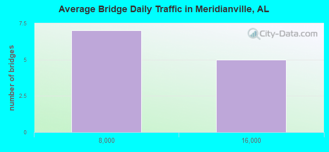
- 79,605Total average daily traffic
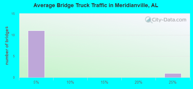
- 2,491Total average daily truck traffic
- 301,833Total future (year 2033) average daily traffic
- National Bridge Inventory (NBI) Registered Bridges for Meridianville
- No street view available for this location
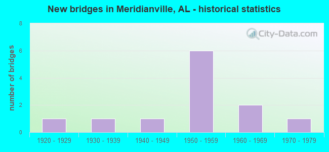
- New bridges - historical statistics
- 11920-1929
- 11930-1939
- 11940-1949
- 61950-1959
- 21960-1969
- 11970-1979
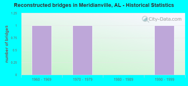
- Reconstructed bridges - Historical Statistics
- 11960-1969
- 11970-1979
- 01980-1989
- 11990-1999
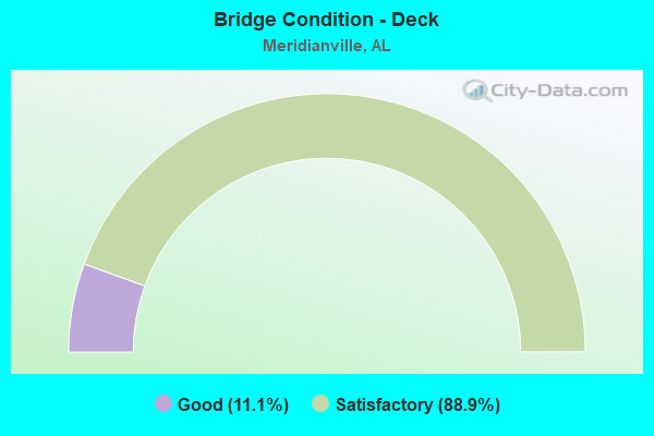
- Bridge Condition - Deck
- 11.1%Good
- 88.9%Satisfactory
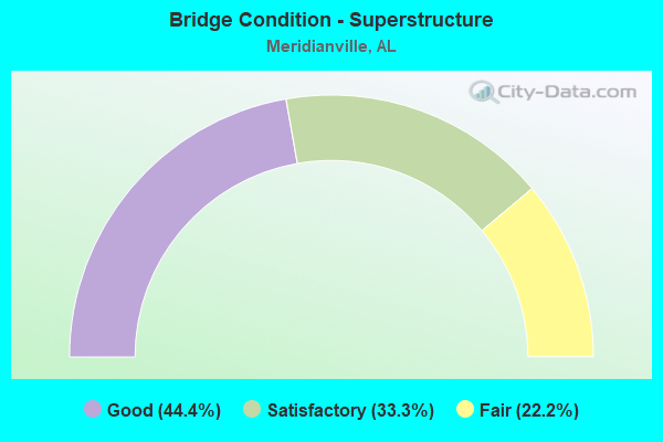
- Bridge Condition - Superstructure
- 44.4%Good
- 33.3%Satisfactory
- 22.2%Fair
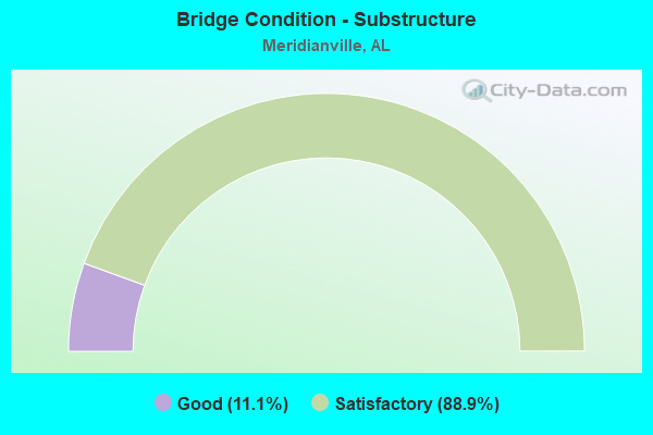
- Bridge Condition - Substructure
- 11.1%Good
- 88.9%Satisfactory
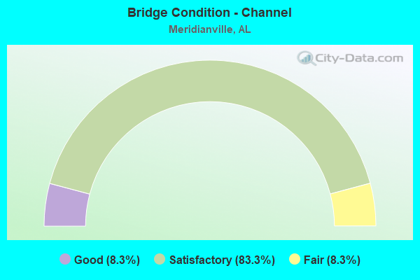
- Bridge Condition - Channel
- 8.3%Good
- 83.3%Satisfactory
- 8.3%Fair
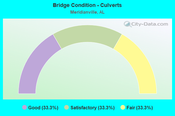
- Bridge Condition - Culverts
- 33.3%Good
- 33.3%Satisfactory
- 33.3%Fair
Find on map >> Show street view
Structure Number: 1499, Location: 0.3 MI N CO RD 137 (Lat: 34.906550, Lng: -86.633936), Route carried "on" structure: County highway 138, Year Built: 1936, Status: Posted for load, Structure Length: 0.91m (2.99ft), Average Daily Traffic: 2,967 (year 2002), Truck Traffic: 1%, Average Future Daily Traffic: 3,560 (year 2034), Design Load: H 15, Features Intersected: BANYON SWAMP BRANCH, Facility Carried by Structure: MURPHY HILL RD
Minimum Vertical Clearance: 30+ m (98+ ft), Kilometerpoint: 0.010, Lanes on structure: 2, Owner: County Highway Agency, Approaching Roadway Width: 8.5m (27.9ft), Material/Design: Steel, Design/Construction: Stringer/Multi-beam, Number Of Spans In Main Unit: 1, Length of Maximum Span: 9.1m (29.9ft), Curb-To-Curb Width: 7.3m (24.0ft), Out-to-Out Width: 8.2m (26.9ft)
Condition: Deck: Satisfactory, Superstructure: Satisfactory, Substructure: Satisfactory, Channel: Satisfactory, Operating Rating: 23.9 metric tons, Method Used To Determine Operating Rating: Allowable Stress (AS), Inventory Rating: 12.5 metric tons, Method Used To Determine Inventory Rating: Allowable Stress (AS), Structural Evaluation: High priority of replacement, Deck Geometry: High priority of replacement, Waterway Adequacy: Somewhat better than minimum adequacy, Approach Roadway Alignment: Meets minimum limits, Bridge Posting: Required (Relationship of Operating Rating to Maximum Legal Load: > 39.9% below), Length Of Structure Improvement: 1.58m (5.18ft), Designated Inspection Frequency: Every 24 months, Other Special Inspection Frequency: Every 12 months, Inspection Date: October 2020, Other Special Inspection Date: October 2021, Bridge Improvement Cost: $282,000, Roadway Improvement Cost: $28,000, Total Project Cost: $310,000 ( Estimate for 2022), Deck Structure Type: Concrete Cast-file-Place
Find on map >> Show street view
Structure Number: 4978, Location: 5.8 MI S. OF CAMDEN (Lat: 31.933139, Lng: -87.253636), Route carried "on" structure: State highway 265, Year Built: 1954, Status: Open, Structure Length: 0.67m (2.20ft), Average Daily Traffic: 430 (year 2013), Truck Traffic: 23%, Average Future Daily Traffic: 525 (year 2033), Design Load: H 15, Features Intersected: SHOAL CREEK
Minimum Vertical Clearance: 30+ m (98+ ft), Kilometerpoint: 25.497, Lanes on structure: 2, Owner: State Highway Agency, Approaching Roadway Width: 9.1m (29.9ft), Material/Design: Concrete, Design/Construction: Culvert, Number Of Spans In Main Unit: 2, Length of Maximum Span: 3.0m (9.8ft)
Condition: Channel: Satisfactory, Culverts: Satisfactory, Operating Rating: 88.9 metric tons, Method Used To Determine Operating Rating: Load Factor (LF), Inventory Rating: 88.9 metric tons, Method Used To Determine Inventory Rating: Load Factor (LF), Structural Evaluation: Equal to present minimum criteria, Waterway Adequacy: Equal to present desirable criteria, Approach Roadway Alignment: Equal to present minimum criteria, Length Of Structure Improvement: 1.30m (4.27ft), Designated Inspection Frequency: Every 24 months, Inspection Date: November 2021, Bridge Improvement Cost: $571,000, Roadway Improvement Cost: $57,000, Total Project Cost: $628,000 ( Estimate for 2022)
Find on map >> Show street view
Structure Number: 5437, Location: 8 MI S TENN ST LINE (Lat: 34.875769, Lng: -86.570439), Route carried "on" structure: US 231, Year Built: 1956, Status: Open, Structure Length: 18.71m (61.38ft), Average Daily Traffic: 13,382 (year 2019), Truck Traffic: 4%, Average Future Daily Traffic: 18,734 (year 2039), Design Load: H 20, Features Intersected: BRIAR FORK FLINT RIVER
Minimum Vertical Clearance: 30+ m (98+ ft), Kilometerpoint: 555.108, Lanes on structure: 2, Owner: State Highway Agency, Approaching Roadway Width: 12.2m (40.0ft), Skew: 10 degrees, Material/Design: Concrete, Design/Construction: Tee Beam, Number Of Spans In Main Unit: 18, Length of Maximum Span: 10.4m (34.1ft), Curb or Sidewalk Widths: Left: 0.5m (1.6ft), Right: 0.5m (1.6ft), Curb-To-Curb Width: 8.5m (27.9ft), Out-to-Out Width: 10.2m (33.5ft)
Condition: Deck: Satisfactory, Superstructure: Satisfactory, Substructure: Satisfactory, Channel: Satisfactory, Operating Rating: 37.5 metric tons, Method Used To Determine Operating Rating: Load Factor (LF), Inventory Rating: 22.5 metric tons, Method Used To Determine Inventory Rating: Load Factor (LF), Structural Evaluation: Somewhat better than minimum adequacy, Deck Geometry: High priority of corrective action, Waterway Adequacy: Equal to present minimum criteria, Approach Roadway Alignment: Equal to present minimum criteria, Length Of Structure Improvement: 19.35m (63.48ft), Designated Inspection Frequency: Every 24 months, Inspection Date: December 2020, Bridge Improvement Cost: $4,378,000, Roadway Improvement Cost: $438,000, Total Project Cost: $4,816,000 ( Estimate for 2022), Deck Structure Type: Concrete Cast-file-Place
Find on map >> Show street view
Structure Number: 5653, Location: 1.5 EAST 231 NORTH (Lat: 34.852144, Lng: -86.544678), Route carried "on" structure: County highway 175, Year Built: 1956, Status: Posted for load, Structure Length: 7.25m (23.79ft), Average Daily Traffic: 1,479 (year 2002), Truck Traffic: 1%, Average Future Daily Traffic: 1,774 (year 2035), Design Load: H 15, Features Intersected: BRIER FORK FLINT RIVER, Facility Carried by Structure: MER. BOTTOM RD
Minimum Vertical Clearance: 30+ m (98+ ft), Kilometerpoint: 0.010, Lanes on structure: 2, Owner: County Highway Agency, Approaching Roadway Width: 7.9m (25.9ft), Material/Design: Concrete, Design/Construction: Tee Beam, Number Of Spans In Main Unit: 7, Length of Maximum Span: 10.4m (34.1ft), Curb-To-Curb Width: 6.7m (22.0ft), Out-to-Out Width: 7.3m (24.0ft)
Condition: Deck: Satisfactory, Superstructure: Good, Substructure: Satisfactory, Channel: Satisfactory, Operating Rating: 41.8 metric tons, Method Used To Determine Operating Rating: Load Factor (LF), Inventory Rating: 25.1 metric tons, Method Used To Determine Inventory Rating: Load Factor (LF), Structural Evaluation: Equal to present minimum criteria, Deck Geometry: High priority of corrective action, Waterway Adequacy: Equal to present minimum criteria, Approach Roadway Alignment: Better than present minimum criteria, Bridge Posting: Required (Relationship of Operating Rating to Maximum Legal Load: 0.1 - 9.9% below), Length Of Structure Improvement: 8.28m (27.17ft), Designated Inspection Frequency: Every 24 months, Other Special Inspection Frequency: Every 12 months, Inspection Date: January 2021, Other Special Inspection Date: January 2022, Bridge Improvement Cost: $1,362,000, Roadway Improvement Cost: $136,000, Total Project Cost: $1,498,000 ( Estimate for 2022), Deck Structure Type: Concrete Cast-file-Place
Find on map >> Show street view
Structure Number: 5654, Location: 1.6 MI EAST HWY 231NORTH (Lat: 34.853353, Lng: -86.543256), Route carried "on" structure: County highway 175, Year Built: 1956, Status: Posted for load, Structure Length: 8.29m (27.20ft), Average Daily Traffic: 1,774 (year 2002), Truck Traffic: 1%, Average Future Daily Traffic: 1,479 (year 2035), Design Load: H 15, Features Intersected: BRIER FORK FLINT RIVER, Facility Carried by Structure: MER. BOTTOM RD
Minimum Vertical Clearance: 30+ m (98+ ft), Kilometerpoint: 0.010, Lanes on structure: 2, Owner: County Highway Agency, Approaching Roadway Width: 7.9m (25.9ft), Material/Design: Concrete, Design/Construction: Tee Beam, Number Of Spans In Main Unit: 8, Length of Maximum Span: 10.4m (34.1ft), Curb-To-Curb Width: 6.7m (22.0ft), Out-to-Out Width: 7.3m (24.0ft)
Condition: Deck: Satisfactory, Superstructure: Satisfactory, Substructure: Satisfactory, Channel: Fair, Operating Rating: 41.8 metric tons, Method Used To Determine Operating Rating: Load Factor (LF), Inventory Rating: 25.1 metric tons, Method Used To Determine Inventory Rating: Load Factor (LF), Structural Evaluation: Equal to present minimum criteria, Deck Geometry: High priority of corrective action, Waterway Adequacy: Equal to present minimum criteria, Approach Roadway Alignment: Better than present minimum criteria, Bridge Posting: Required (Relationship of Operating Rating to Maximum Legal Load: 0.1 - 9.9% below), Length Of Structure Improvement: 9.29m (30.48ft), Designated Inspection Frequency: Every 24 months, Other Special Inspection Frequency: Every 12 months, Inspection Date: January 2021, Other Special Inspection Date: January 2022, Bridge Improvement Cost: $1,528,000, Roadway Improvement Cost: $153,000, Total Project Cost: $1,681,000 ( Estimate for 2022), Deck Structure Type: Concrete Cast-file-Place
Find on map >> Show street view
Structure Number: 6347, Location: 1.5 MI W US HWY 431 (Lat: 34.859028, Lng: -86.597122), Route carried "on" structure: County highway 75, Year Built: 1958, Status: Posted for load, Structure Length: 7.25m (23.79ft), Average Daily Traffic: 1,724 (year 2002), Truck Traffic: 1%, Average Future Daily Traffic: 2,068 (year 2040), Design Load: H 15, Features Intersected: BEAVER DAM CREEK, Facility Carried by Structure: MONROE RD
Minimum Vertical Clearance: 30+ m (98+ ft), Kilometerpoint: 0.010, Lanes on structure: 2, Owner: County Highway Agency, Approaching Roadway Width: 8.5m (27.9ft), Material/Design: Concrete, Design/Construction: Tee Beam, Number Of Spans In Main Unit: 7, Length of Maximum Span: 10.4m (34.1ft), Curb-To-Curb Width: 6.7m (22.0ft), Out-to-Out Width: 7.3m (24.0ft)
Condition: Deck: Satisfactory, Superstructure: Good, Substructure: Satisfactory, Channel: Satisfactory, Operating Rating: 36.0 metric tons, Method Used To Determine Operating Rating: Load Factor (LF), Inventory Rating: 21.6 metric tons, Method Used To Determine Inventory Rating: Load Factor (LF), Structural Evaluation: Somewhat better than minimum adequacy, Deck Geometry: High priority of corrective action, Waterway Adequacy: Equal to present minimum criteria, Approach Roadway Alignment: Better than present minimum criteria, Bridge Posting: Required (Relationship of Operating Rating to Maximum Legal Load: 0.1 - 9.9% below), Length Of Structure Improvement: 8.28m (27.17ft), Designated Inspection Frequency: Every 24 months, Other Special Inspection Frequency: Every 12 months, Inspection Date: December 2020, Other Special Inspection Date: December 2021, Bridge Improvement Cost: $1,362,000, Roadway Improvement Cost: $136,000, Total Project Cost: $1,498,000 ( Estimate for 2022), Deck Structure Type: Concrete Cast-file-Place
Find on map >> Show street view
Structure Number: 6532, Location: 11 MI S ALA-TENN ST LINE (Lat: 34.837783, Lng: -86.571222), Route carried "on" structure: US 231, Year Built: 1959, Status: Open, Structure Length: 7.71m (25.30ft), Average Daily Traffic: 13,382 (year 2019), Truck Traffic: 4%, Average Future Daily Traffic: 18,735 (year 2039), Design Load: HS 20, Features Intersected: BEAVER DAM CREEK
Minimum Vertical Clearance: 30+ m (98+ ft), Kilometerpoint: 550.777, Lanes on structure: 2, Owner: State Highway Agency, Approaching Roadway Width: 12.2m (40.0ft), Skew: 10 degrees, Material/Design: Concrete, Design/Construction: Tee Beam, Number Of Spans In Main Unit: 9, Length of Maximum Span: 8.5m (27.9ft), Curb-To-Curb Width: 8.5m (27.9ft), Out-to-Out Width: 10.1m (33.1ft)
Condition: Deck: Satisfactory, Superstructure: Fair, Substructure: Satisfactory, Channel: Satisfactory, Operating Rating: 40.9 metric tons, Method Used To Determine Operating Rating: Load Factor (LF), Inventory Rating: 24.6 metric tons, Method Used To Determine Inventory Rating: Load Factor (LF), Structural Evaluation: Somewhat better than minimum adequacy, Deck Geometry: High priority of corrective action, Waterway Adequacy: Equal to present minimum criteria, Approach Roadway Alignment: Better than present minimum criteria, Length Of Structure Improvement: 8.73m (28.64ft), Designated Inspection Frequency: Every 24 months, Inspection Date: December 2020, Bridge Improvement Cost: $1,976,000, Roadway Improvement Cost: $198,000, Total Project Cost: $2,174,000 ( Estimate for 2022), Deck Structure Type: Concrete Cast-file-Place
Find on map >> Show street view
Structure Number: 675, Location: 11 MI S ALA-TENN ST LINE (Lat: 34.837789, Lng: -86.571397), Route carried "on" structure: US 231, Year Built: 1929, Year Reconstructed: 1960, Status: Open, Structure Length: 7.82m (25.66ft), Average Daily Traffic: 13,382 (year 2019), Truck Traffic: 4%, Average Future Daily Traffic: 18,735 (year 2039), Design Load: H 15, Features Intersected: BEAVER DAM CREEK
Minimum Vertical Clearance: 30+ m (98+ ft), Kilometerpoint: 550.777, Lanes on structure: 2, Owner: State Highway Agency, Approaching Roadway Width: 12.2m (40.0ft), Skew: 10 degrees, Material/Design: Concrete, Design/Construction: Tee Beam, Number Of Spans In Main Unit: 9, Length of Maximum Span: 8.7m (28.5ft), Curb-To-Curb Width: 8.5m (27.9ft), Out-to-Out Width: 10.2m (33.5ft)
Condition: Deck: Satisfactory, Superstructure: Fair, Substructure: Satisfactory, Channel: Satisfactory, Operating Rating: 57.2 metric tons, Method Used To Determine Operating Rating: Load Factor (LF), Inventory Rating: 34.3 metric tons, Method Used To Determine Inventory Rating: Load Factor (LF), Structural Evaluation: Somewhat better than minimum adequacy, Deck Geometry: High priority of corrective action, Waterway Adequacy: Equal to present minimum criteria, Approach Roadway Alignment: Equal to present desirable criteria, Length Of Structure Improvement: 8.83m (28.97ft), Designated Inspection Frequency: Every 24 months, Inspection Date: December 2020, Bridge Improvement Cost: $1,998,000, Roadway Improvement Cost: $200,000, Total Project Cost: $2,198,000 ( Estimate for 2022), Deck Structure Type: Concrete Cast-file-Place
Find on map >> Show street view
Structure Number: 7125, Location: 0.5 MI CO RD 157 (Lat: 34.873928, Lng: -86.606967), Route carried "on" structure: County highway 116, Year Built: 1960, Status: Posted for load, Structure Length: 7.25m (23.79ft), Average Daily Traffic: 903 (year 2001), Truck Traffic: 1%, Average Future Daily Traffic: 1,083 (year 2035), Design Load: H 15, Features Intersected: BEAVER DAM CREEK, Facility Carried by Structure: MT LEBANON RD
Minimum Vertical Clearance: 30+ m (98+ ft), Kilometerpoint: 0.010, Lanes on structure: 2, Owner: County Highway Agency, Approaching Roadway Width: 8.5m (27.9ft), Material/Design: Concrete, Design/Construction: Tee Beam, Number Of Spans In Main Unit: 7, Length of Maximum Span: 10.4m (34.1ft), Curb-To-Curb Width: 6.7m (22.0ft), Out-to-Out Width: 7.3m (24.0ft)
Condition: Deck: Satisfactory, Superstructure: Good, Substructure: Satisfactory, Channel: Satisfactory, Operating Rating: 41.8 metric tons, Method Used To Determine Operating Rating: Load Factor (LF), Inventory Rating: 25.1 metric tons, Method Used To Determine Inventory Rating: Load Factor (LF), Structural Evaluation: Equal to present minimum criteria, Deck Geometry: Meets minimum limits, Waterway Adequacy: Better than present minimum criteria, Approach Roadway Alignment: Somewhat better than minimum adequacy, Bridge Posting: Required (Relationship of Operating Rating to Maximum Legal Load: 0.1 - 9.9% below), Length Of Structure Improvement: 8.28m (27.17ft), Designated Inspection Frequency: Every 24 months, Other Special Inspection Frequency: Every 12 months, Inspection Date: October 2020, Other Special Inspection Date: October 2021, Bridge Improvement Cost: $1,362,000, Roadway Improvement Cost: $136,000, Total Project Cost: $1,498,000 ( Estimate for 2022), Deck Structure Type: Concrete Cast-file-Place
Find on map >> Show street view
Structure Number: 9391, Location: INT MICHAEL BLVD/DAVIDSON (Lat: 30.665158, Lng: -88.144133), Route carried "on" structure: City street , Year Built: 1967, Year Reconstructed: 2002, Status: Open, Structure Length: 1.32m (4.33ft), Average Daily Traffic: 14,324 (year 2021), Truck Traffic: 1%, Average Future Daily Traffic: 213,434 (year 2041), Design Load: H 15, Features Intersected: BOLTON BRANCH, Facility Carried by Structure: DAVIDSON SCHOOL D
Minimum Vertical Clearance: 30+ m (98+ ft), Kilometerpoint: 0.200, Lanes on structure: 2, Owner: City or Municipal Highway Agency, Approaching Roadway Width: 7.6m (24.9ft), Material/Design: Concrete, Design/Construction: Culvert, Number Of Spans In Main Unit: 4, Length of Maximum Span: 3.0m (9.8ft), Curb or Sidewalk Widths: Left: 0.5m (1.6ft), Right: 0.5m (1.6ft)
Condition: Channel: Satisfactory, Culverts: Fair, Operating Rating: 88.9 metric tons, Method Used To Determine Operating Rating: Load Factor (LF), Inventory Rating: 80.7 metric tons, Method Used To Determine Inventory Rating: Load Factor (LF), Structural Evaluation: Somewhat better than minimum adequacy, Waterway Adequacy: Better than present minimum criteria, Approach Roadway Alignment: Equal to present desirable criteria, Length Of Structure Improvement: 2.00m (6.56ft), Designated Inspection Frequency: Every 24 months, Inspection Date: October 2021, Bridge Improvement Cost: $1,200,000, Roadway Improvement Cost: $120,000, Total Project Cost: $1,320,000 ( Estimate for 2022)
Find on map >> Show street view
Structure Number: 11176, Location: 8 MI S TENN ST LINE (Lat: 34.875842, Lng: -86.570608), Route carried "on" structure: US 231, Year Built: 1974, Status: Open, Structure Length: 18.65m (61.19ft), Average Daily Traffic: 13,382 (year 2019), Truck Traffic: 4%, Average Future Daily Traffic: 18,735 (year 2039), Design Load: HS 20, Features Intersected: BRIAR FORK FLINT RIVER
Minimum Vertical Clearance: 30+ m (98+ ft), Kilometerpoint: 555.108, Lanes on structure: 2, Owner: State Highway Agency, Approaching Roadway Width: 12.2m (40.0ft), Skew: 10 degrees, Material/Design: Concrete, Design/Construction: Tee Beam, Number Of Spans In Main Unit: 18, Length of Maximum Span: 10.4m (34.1ft), Curb or Sidewalk Widths: Left: 0.2m (0.7ft), Right: 0.2m (0.7ft), Curb-To-Curb Width: 12.0m (39.4ft), Out-to-Out Width: 13.1m (43.0ft)
Condition: Deck: Good, Superstructure: Good, Substructure: Good, Channel: Satisfactory, Operating Rating: 45.0 metric tons, Method Used To Determine Operating Rating: Load Factor (LF), Inventory Rating: 26.9 metric tons, Method Used To Determine Inventory Rating: Load Factor (LF), Structural Evaluation: Equal to present minimum criteria, Deck Geometry: Better than present minimum criteria, Waterway Adequacy: Better than present minimum criteria, Approach Roadway Alignment: Equal to present minimum criteria, Length Of Structure Improvement: 19.29m (63.29ft), Designated Inspection Frequency: Every 24 months, Inspection Date: December 2020, Bridge Improvement Cost: $5,688,000, Roadway Improvement Cost: $569,000, Total Project Cost: $6,257,000 ( Estimate for 2022), Deck Structure Type: Concrete Cast-file-Place
Find on map >> Show street view
Structure Number: 13104, Location: 0.8 MI W JCT CO RD 138 (Lat: 34.880692, Lng: -86.614058), Route carried "on" structure: County highway 157, Year Built: 1946, Year Reconstructed: 1984, Status: Open, Structure Length: 1.07m (3.51ft), Average Daily Traffic: 2,476 (year 2002), Truck Traffic: 1%, Average Future Daily Traffic: 2,971 (year 2035), Design Load: HS 20, Features Intersected: BEAVER DAM CREEK, Facility Carried by Structure: PATTERSON LA
Minimum Vertical Clearance: 30+ m (98+ ft), Kilometerpoint: 0.010, Lanes on structure: 2, Owner: County Highway Agency, Approaching Roadway Width: 14.0m (45.9ft), Skew: 2 degrees, Material/Design: Concrete, Design/Construction: Culvert, Number Of Spans In Main Unit: 3, Length of Maximum Span: 3.0m (9.8ft), Curb-To-Curb Width: 13.5m (44.3ft), Out-to-Out Width: 14.0m (45.9ft)
Condition: Channel: Good, Culverts: Good, Operating Rating: 59.4 metric tons, Method Used To Determine Operating Rating: Load Factor (LF), Inventory Rating: 35.7 metric tons, Method Used To Determine Inventory Rating: Load Factor (LF), Structural Evaluation: Better than present minimum criteria, Deck Geometry: Superior to present desirable criteria, Waterway Adequacy: Better than present minimum criteria, Approach Roadway Alignment: Better than present minimum criteria, Length Of Structure Improvement: 1.74m (5.71ft), Designated Inspection Frequency: Every 24 months, Inspection Date: October 2020, Bridge Improvement Cost: $463,000, Roadway Improvement Cost: $46,000, Total Project Cost: $509,000 ( Estimate for 2022)