Bridge Statistics for Merom, Indiana (IN)
Condition, Traffic, Stress, Structural Evaluation, Project Costs
- National Bridge Inventory (NBI) Statistics
- 10Number of bridges
- 66ft / 20.5mTotal length
- $2,977,000Total costs
- 2,484Total average daily traffic
- 121Total average daily truck traffic
- 3,331Total future (year 2030) average daily traffic
- National Bridge Inventory (NBI) Registered Bridges for Merom
- No street view available for this location
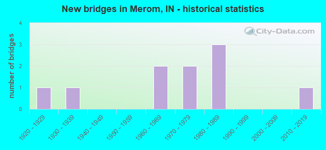
- New bridges - historical statistics
- 11920-1929
- 11930-1939
- 21960-1969
- 21970-1979
- 31980-1989
- 12010-2019

- Bridge Condition - Deck
- 11.1%Very good
- 33.3%Good
- 33.3%Satisfactory
- 22.2%Fair

- Bridge Condition - Superstructure
- 20.0%Good
- 40.0%Satisfactory
- 40.0%Fair

- Bridge Condition - Substructure
- 10.0%Very good
- 20.0%Good
- 50.0%Satisfactory
- 20.0%Fair

- Bridge Condition - Channel
- 10.0%Very good
- 20.0%Good
- 40.0%Satisfactory
- 20.0%Fair
- 10.0%Poor
Find on map >> Show street view
Structure Number: 2075, Location: 02.82 E SR 63 (Lat: 39.032911, Lng: -87.539589), Route carried "on" structure: State highway 58, Year Built: 1965, Year Reconstructed: 2000, Status: Open, Structure Length: 4.77m (15.65ft), Average Daily Traffic: 874 (year 2004), Truck Traffic: 10%, Average Future Daily Traffic: 1,451 (year 2030), Design Load: HS 20, Features Intersected: TURTLE CREEK
Minimum Vertical Clearance: 30+ m (98+ ft), Kilometerpoint: 4.538, Lanes on structure: 2, Owner: State Highway Agency, Approaching Roadway Width: 7.3m (24.0ft), Skew: 1 degrees, Material/Design: Prestressed concrete, Design/Construction: Stringer/Multi-beam, Number Of Spans In Main Unit: 3, Length of Maximum Span: 20.1m (65.9ft), Curb-To-Curb Width: 8.5m (27.9ft), Out-to-Out Width: 10.0m (32.8ft)
Condition: Deck: Satisfactory, Superstructure: Fair, Substructure: Satisfactory, Channel: Good, Operating Rating: 37.6 metric tons, Method Used To Determine Operating Rating: Load and Resistance Factor Rating (LRFR) rating reported by rating factor(RF) method using HL-93 loadings, Inventory Rating: 18.1 metric tons, Method Used To Determine Inventory Rating: Load and Resistance Factor Rating (LRFR) rating reported by rating factor(RF) method using HL-93 loadings, Structural Evaluation: Somewhat better than minimum adequacy, Deck Geometry: Somewhat better than minimum adequacy, Waterway Adequacy: Superior to present desirable criteria, Approach Roadway Alignment: Equal to present desirable criteria, Designated Inspection Frequency: Every 24 months, Inspection Date: November 2021, Deck Structure Type: Concrete Cast-file-Place, Wearing Surface/Protective System: Wearing Surface: Latex Concrete
Find on map >> Show street view
Structure Number: 7700063, Location: 00.25 N OF CR 400 S (Lat: 39.030419, Lng: -87.508450), Route carried "on" structure: Alternate County highway 21, Year Built: 1989, Status: Open, Structure Length: 2.59m (8.50ft), Average Daily Traffic: 110 (year 2011), Truck Traffic: 2%, Average Future Daily Traffic: 130 (year 2031), Features Intersected: LITTLE TURTLE CREEK, Facility Carried by Structure: CR 550 W
Minimum Vertical Clearance: 30+ m (98+ ft), Kilometerpoint: 0.000, Lanes on structure: 2, Owner: County Highway Agency, Approaching Roadway Width: 4.3m (14.1ft), Material/Design: Steel, Number Of Spans In Main Unit: 1, Length of Maximum Span: 25.3m (83.0ft), Curb-To-Curb Width: 5.7m (18.7ft), Out-to-Out Width: 5.9m (19.4ft)
Condition: Deck: Fair, Superstructure: Fair, Substructure: Satisfactory, Channel: Satisfactory, Operating Rating: 32.7 metric tons, Method Used To Determine Operating Rating: Field evaluation and documented engineering judgment, Inventory Rating: 32.7 metric tons, Method Used To Determine Inventory Rating: Field evaluation and documented engineering judgment, Structural Evaluation: Somewhat better than minimum adequacy, Deck Geometry: High priority of corrective action, Waterway Adequacy: Meets minimum limits, Approach Roadway Alignment: Equal to present desirable criteria, Length Of Structure Improvement: 3.51m (11.52ft), Designated Inspection Frequency: Every 24 months, Critical Feature Inspection Frequency: Every 24 months, Inspection Date: August 2021, Critical Feature Inspection Date: August 2021, Bridge Improvement Cost: $435,000, Roadway Improvement Cost: $169,000, Total Project Cost: $763,000 ( Estimate for 2017), Deck Structure Type: Steel plate, Wearing Surface/Protective System: Wearing Surface: Gravel
Find on map >> Show street view
Structure Number: 7700065, Location: 00.42 N OF CR 450 S (Lat: 39.027644, Lng: -87.550422), Route carried "on" structure: Alternate County highway 9, Year Built: 1965, Status: Posted for load, Structure Length: 2.13m (6.99ft), Average Daily Traffic: 140 (year 2011), Truck Traffic: 2%, Average Future Daily Traffic: 160 (year 2031), Design Load: H 20, Features Intersected: TURTLE CREEK, Facility Carried by Structure: CR 775 W
Minimum Vertical Clearance: 30+ m (98+ ft), Kilometerpoint: 0.000, Lanes on structure: 2, Owner: County Highway Agency, Approaching Roadway Width: 5.2m (17.1ft), Material/Design: Concrete, Design/Construction: Channel Beam, Number Of Spans In Main Unit: 3, Length of Maximum Span: 9.1m (29.9ft), Curb or Sidewalk Widths: Left: 0.2m (0.7ft), Right: 0.2m (0.7ft), Curb-To-Curb Width: 6.2m (20.3ft), Out-to-Out Width: 6.8m (22.3ft)
Condition: Deck: Fair, Superstructure: Fair, Substructure: Fair, Channel: Fair, Operating Rating: 35.4 metric tons, Method Used To Determine Operating Rating: Load Factor (LF), Inventory Rating: 20.9 metric tons, Method Used To Determine Inventory Rating: Load Factor (LF), Structural Evaluation: Somewhat better than minimum adequacy, Deck Geometry: Meets minimum limits, Waterway Adequacy: Equal to present minimum criteria, Approach Roadway Alignment: Equal to present desirable criteria, Length Of Structure Improvement: 2.93m (9.61ft), Designated Inspection Frequency: Every 24 months, Inspection Date: August 2021, Bridge Improvement Cost: $363,000, Roadway Improvement Cost: $169,000, Total Project Cost: $672,000 ( Estimate for 2017), Deck Structure Type: Concrete Precast Panels, Wearing Surface/Protective System: Wearing Surface: Monolithic Concrete
Find on map >> Show street view
Structure Number: 7700071, Location: 00.16 W OF CR 625 W (Lat: 39.041692, Lng: -87.525139), Route carried "on" structure: Alternate County highway 540, Year Built: 1980, Status: Open, Structure Length: 1.65m (5.41ft), Average Daily Traffic: 560 (year 2011), Truck Traffic: 3%, Average Future Daily Traffic: 650 (year 2031), Features Intersected: TURTLE CREEK, Facility Carried by Structure: CR 300 S
Minimum Vertical Clearance: 30+ m (98+ ft), Kilometerpoint: 0.000, Lanes on structure: 2, Owner: County Highway Agency, Approaching Roadway Width: 6.4m (21.0ft), Material/Design: Steel continuous, Design/Construction: Stringer/Multi-beam, Number Of Spans In Main Unit: 2, Length of Maximum Span: 7.9m (25.9ft), Curb or Sidewalk Widths: Left: 0.2m (0.7ft), Right: 0.2m (0.7ft), Curb-To-Curb Width: 8.8m (28.9ft), Out-to-Out Width: 9.4m (30.8ft)
Condition: Deck: Good, Superstructure: Satisfactory, Substructure: Satisfactory, Channel: Good, Operating Rating: 97.2 metric tons, Method Used To Determine Operating Rating: Load and Resistance Factor Rating (LRFR) rating reported by rating factor(RF) method using HL-93 loadings, Inventory Rating: 79.1 metric tons, Method Used To Determine Inventory Rating: Load and Resistance Factor Rating (LRFR) rating reported by rating factor(RF) method using HL-93 loadings, Structural Evaluation: Equal to present minimum criteria, Deck Geometry: Somewhat better than minimum adequacy, Waterway Adequacy: Equal to present desirable criteria, Approach Roadway Alignment: Equal to present desirable criteria, Designated Inspection Frequency: Every 24 months, Inspection Date: August 2021, Deck Structure Type: Concrete Cast-file-Place, Wearing Surface/Protective System: Wearing Surface: Bituminous
Find on map >> Show street view
Structure Number: 7700076, Location: 00.02 S OF CR 300 S (Lat: 39.041372, Lng: -87.522264), Route carried "on" structure: Alternate County highway 113, Year Built: 1930, Status: Posted for load, Structure Length: 1.77m (5.81ft), Average Daily Traffic: 110 (year 2011), Truck Traffic: 2%, Average Future Daily Traffic: 130 (year 2031), Features Intersected: LITTLE TURTLE CREEK, Facility Carried by Structure: CR 625 W
Minimum Vertical Clearance: 30+ m (98+ ft), Kilometerpoint: 0.000, Lanes on structure: 2, Owner: County Highway Agency, Approaching Roadway Width: 4.0m (13.1ft), Material/Design: Concrete, Design/Construction: Arch - Deck, Number Of Spans In Main Unit: 1, Length of Maximum Span: 15.9m (52.2ft), Curb-To-Curb Width: 6.6m (21.7ft), Out-to-Out Width: 7.4m (24.3ft)
Condition: Superstructure: Fair, Substructure: Satisfactory, Channel: Satisfactory, Operating Rating: 16.3 metric tons, Method Used To Determine Operating Rating: Field evaluation and documented engineering judgment, Inventory Rating: 12.7 metric tons, Method Used To Determine Inventory Rating: Field evaluation and documented engineering judgment, Structural Evaluation: Meets minimum limits, Deck Geometry: Meets minimum limits, Waterway Adequacy: Equal to present minimum criteria, Approach Roadway Alignment: High priority of corrective action, Bridge Posting: Required (Relationship of Operating Rating to Maximum Legal Load: > 39.9% below), Length Of Structure Improvement: 2.47m (8.10ft), Designated Inspection Frequency: Every 24 months, Inspection Date: August 2021, Bridge Improvement Cost: $308,000, Roadway Improvement Cost: $169,000, Total Project Cost: $602,000
Find on map >> Show street view
Structure Number: 770019, Location: 00.22 E OF CR 600 W (Lat: 39.088506, Lng: -87.513244), Route carried "on" structure: Alternate County highway 48, Year Built: 1976, Status: Posted for load, Structure Length: 1.65m (5.41ft), Average Daily Traffic: 220 (year 2011), Truck Traffic: 2%, Average Future Daily Traffic: 260 (year 2031), Features Intersected: TURTLE CREEK, Facility Carried by Structure: CR 25 N
Minimum Vertical Clearance: 30+ m (98+ ft), Kilometerpoint: 0.000, Lanes on structure: 2, Owner: County Highway Agency, Approaching Roadway Width: 5.8m (19.0ft), Material/Design: Steel, Design/Construction: Stringer/Multi-beam, Number Of Spans In Main Unit: 1, Length of Maximum Span: 15.2m (49.9ft), Curb-To-Curb Width: 8.5m (27.9ft), Out-to-Out Width: 9.1m (29.9ft)
Condition: Deck: Good, Superstructure: Good, Substructure: Good, Channel: Satisfactory, Operating Rating: 21.4 metric tons, Method Used To Determine Operating Rating: Load and Resistance Factor Rating (LRFR) rating reported by rating factor(RF) method using HL-93 loadings, Inventory Rating: 16.5 metric tons, Method Used To Determine Inventory Rating: Load and Resistance Factor Rating (LRFR) rating reported by rating factor(RF) method using HL-93 loadings, Structural Evaluation: Somewhat better than minimum adequacy, Deck Geometry: Equal to present minimum criteria, Waterway Adequacy: High priority of corrective action, Approach Roadway Alignment: Equal to present desirable criteria, Bridge Posting: Required (Relationship of Operating Rating to Maximum Legal Load: > 39.9% below), Length Of Structure Improvement: 1.65m (5.41ft), Designated Inspection Frequency: Every 24 months, Underwater Inspection Frequency: Every 60 months, Inspection Date: August 2021, Underwater Inspection Date: October 2021, Bridge Improvement Cost: $113,000, Total Project Cost: $113,000 ( Estimate for 2017), Deck Structure Type: Concrete Cast-file-Place, Wearing Surface/Protective System: Wearing Surface: Bituminous
Find on map >> Show street view
Structure Number: 7700192, Location: 00.42 E OF CR 700 W (Lat: 39.092028, Lng: -87.528306), Route carried "on" structure: Alternate County highway 204, Year Built: 1970, Status: Posted for load, Structure Length: 1.62m (5.31ft), Average Daily Traffic: 110 (year 2011), Truck Traffic: 3%, Average Future Daily Traffic: 130 (year 2031), Design Load: HS 20, Features Intersected: BRANCH OF TURTLE CREEK, Facility Carried by Structure: CR 50N
Minimum Vertical Clearance: 30+ m (98+ ft), Kilometerpoint: 0.000, Lanes on structure: 2, Owner: County Highway Agency, Approaching Roadway Width: 5.5m (18.0ft), Material/Design: Steel, Design/Construction: Stringer/Multi-beam, Number Of Spans In Main Unit: 1, Length of Maximum Span: 14.9m (48.9ft), Curb-To-Curb Width: 8.4m (27.6ft), Out-to-Out Width: 8.5m (27.9ft)
Condition: Deck: Good, Superstructure: Satisfactory, Substructure: Good, Channel: Fair, Operating Rating: 28.5 metric tons, Method Used To Determine Operating Rating: Load and Resistance Factor Rating (LRFR) rating reported by rating factor(RF) method using HL-93 loadings, Inventory Rating: 22.0 metric tons, Method Used To Determine Inventory Rating: Load and Resistance Factor Rating (LRFR) rating reported by rating factor(RF) method using HL-93 loadings, Structural Evaluation: Equal to present minimum criteria, Deck Geometry: Somewhat better than minimum adequacy, Waterway Adequacy: High priority of corrective action, Approach Roadway Alignment: Equal to present minimum criteria, Bridge Posting: Required (Relationship of Operating Rating to Maximum Legal Load: 30.0 - 39.9% below), Length Of Structure Improvement: 1.62m (5.31ft), Designated Inspection Frequency: Every 24 months, Inspection Date: August 2021, Bridge Improvement Cost: $111,000, Roadway Improvement Cost: $169,000, Total Project Cost: $339,000, Deck Structure Type: Concrete Cast-file-Place, Wearing Surface/Protective System: Wearing Surface: Bituminous
Find on map >> Show street view
Structure Number: 7700193, Location: 00.14 S OF CR 25 N (Lat: 39.087392, Lng: -87.567453), Route carried "on" structure: Alternate County highway 3, Year Built: 1920, Status: Posted for load, Structure Length: 1.07m (3.51ft), Average Daily Traffic: 110 (year 2011), Truck Traffic: 2%, Average Future Daily Traffic: 130 (year 2031), Features Intersected: BRANCH CLEAR POND DITCH, Facility Carried by Structure: CR 900 W
Minimum Vertical Clearance: 30+ m (98+ ft), Kilometerpoint: 0.000, Lanes on structure: 2, Owner: County Highway Agency, Approaching Roadway Width: 4.6m (15.1ft), Material/Design: Concrete, Design/Construction: Arch - Deck, Number Of Spans In Main Unit: 1, Length of Maximum Span: 9.8m (32.2ft), Curb-To-Curb Width: 5.6m (18.4ft), Out-to-Out Width: 6.1m (20.0ft)
Condition: Deck: Satisfactory, Superstructure: Satisfactory, Substructure: Fair, Channel: Poor, Operating Rating: 22.7 metric tons, Method Used To Determine Operating Rating: Field evaluation and documented engineering judgment, Inventory Rating: 19.0 metric tons, Method Used To Determine Inventory Rating: Field evaluation and documented engineering judgment, Structural Evaluation: Somewhat better than minimum adequacy, Deck Geometry: High priority of corrective action, Waterway Adequacy: Somewhat better than minimum adequacy, Approach Roadway Alignment: High priority of corrective action, Bridge Posting: Required (Relationship of Operating Rating to Maximum Legal Load: 30.0 - 39.9% below), Length Of Structure Improvement: 1.74m (5.71ft), Designated Inspection Frequency: Every 24 months, Inspection Date: August 2021, Bridge Improvement Cost: $217,000, Roadway Improvement Cost: $169,000, Total Project Cost: $488,000 ( Estimate for 2017)
Find on map >> Show street view
Structure Number: 7700281, Location: 00.19 E OF CR 700 W (Lat: 39.099272, Lng: -87.532583), Route carried "on" structure: Alternate County highway 208, Year Built: 1980, Status: Open, Structure Length: 0.85m (2.79ft), Average Daily Traffic: 110 (year 2011), Truck Traffic: 1%, Average Future Daily Traffic: 130 (year 2031), Features Intersected: BRANCH OF TURTLE CREEK, Facility Carried by Structure: CR 100 N
Minimum Vertical Clearance: 30+ m (98+ ft), Kilometerpoint: 0.000, Lanes on structure: 2, Owner: County Highway Agency, Approaching Roadway Width: 3.7m (12.1ft), Material/Design: Prestressed concrete, Design/Construction: Box Beam or Girders - Multiple, Number Of Spans In Main Unit: 1, Length of Maximum Span: 7.9m (25.9ft), Curb-To-Curb Width: 8.5m (27.9ft), Out-to-Out Width: 8.6m (28.2ft)
Condition: Deck: Satisfactory, Superstructure: Satisfactory, Substructure: Satisfactory, Channel: Satisfactory, Operating Rating: 42.8 metric tons, Method Used To Determine Operating Rating: Load and Resistance Factor Rating (LRFR) rating reported by rating factor(RF) method using HL-93 loadings, Inventory Rating: 25.9 metric tons, Method Used To Determine Inventory Rating: Load and Resistance Factor Rating (LRFR) rating reported by rating factor(RF) method using HL-93 loadings, Structural Evaluation: Equal to present minimum criteria, Deck Geometry: Equal to present minimum criteria, Waterway Adequacy: Somewhat better than minimum adequacy, Approach Roadway Alignment: Equal to present minimum criteria, Designated Inspection Frequency: Every 24 months, Inspection Date: August 2021, Deck Structure Type: Concrete Precast Panels, Wearing Surface/Protective System: Wearing Surface: Bituminous
Find on map >> Show street view
Structure Number: 7700309, Location: 00.18 S OF CR 975 W (Lat: 39.096661, Lng: -87.571664), Route carried "on" structure: Alternate County highway 3, Year Built: 2017, Status: Open, Structure Length: 2.38m (7.81ft), Average Daily Traffic: 140 (year 2011), Truck Traffic: 2%, Average Future Daily Traffic: 160 (year 2031), Features Intersected: CLEAR POND DITCH, Facility Carried by Structure: CR 900 W
Minimum Vertical Clearance: 30+ m (98+ ft), Kilometerpoint: 0.000, Lanes on structure: 2, Owner: County Highway Agency, Approaching Roadway Width: 5.5m (18.0ft), Skew: 3 degrees, Material/Design: Steel, Design/Construction: Stringer/Multi-beam, Number Of Spans In Main Unit: 1, Length of Maximum Span: 23.2m (76.1ft), Curb-To-Curb Width: 7.2m (23.6ft), Out-to-Out Width: 7.3m (24.0ft)
Condition: Deck: Very good, Superstructure: Good, Substructure: Very good, Channel: Very good, Operating Rating: 32.7 metric tons, Method Used To Determine Operating Rating: Field evaluation and documented engineering judgment, Inventory Rating: 32.7 metric tons, Method Used To Determine Inventory Rating: Field evaluation and documented engineering judgment, Structural Evaluation: Better than present minimum criteria, Deck Geometry: Meets minimum limits, Waterway Adequacy: Somewhat better than minimum adequacy, Approach Roadway Alignment: Equal to present desirable criteria, Designated Inspection Frequency: Every 24 months, Inspection Date: August 2021, Deck Structure Type: Open Grating