Bridge Statistics for Merriam, Kansas (KS)
Condition, Traffic, Stress, Structural Evaluation, Project Costs
- National Bridge Inventory (NBI) Statistics
- 40Number of bridges
- 459ft / 140mTotal length
- $1,501,000Total costs
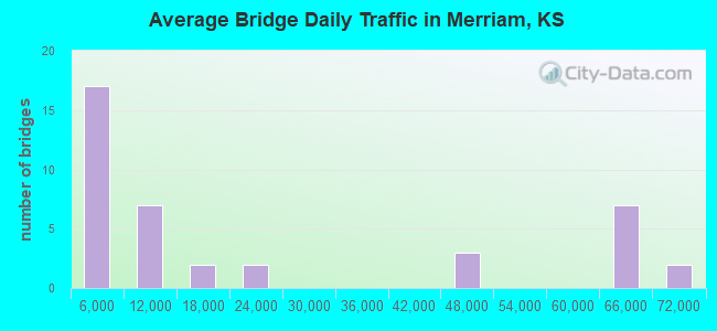
- 860,466Total average daily traffic
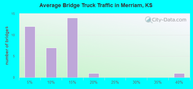
- 80,087Total average daily truck traffic
- National Bridge Inventory (NBI) Registered Bridges for Merriam
- No street view available for this location
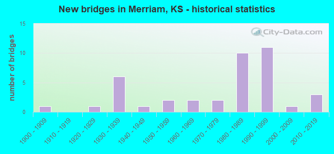
- New bridges - historical statistics
- 11900-1909
- 11920-1929
- 61930-1939
- 11940-1949
- 21950-1959
- 21960-1969
- 21970-1979
- 101980-1989
- 111990-1999
- 12000-2009
- 32010-2019
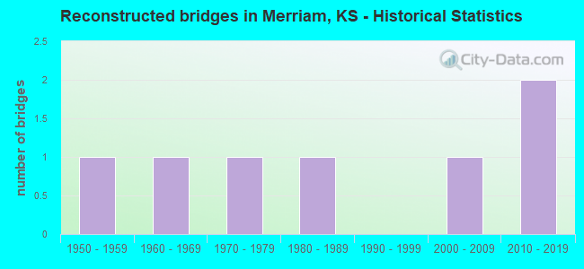
- Reconstructed bridges - Historical Statistics
- 11950-1959
- 11960-1969
- 11970-1979
- 11980-1989
- 01990-1999
- 12000-2009
- 22010-2019
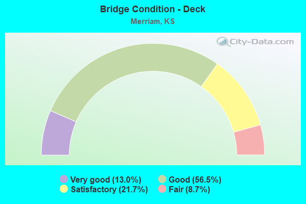
- Bridge Condition - Deck
- 13.0%Very good
- 56.5%Good
- 21.7%Satisfactory
- 8.7%Fair
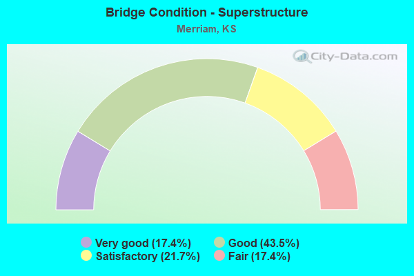
- Bridge Condition - Superstructure
- 17.4%Very good
- 43.5%Good
- 21.7%Satisfactory
- 17.4%Fair
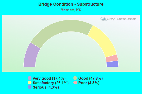
- Bridge Condition - Substructure
- 17.4%Very good
- 47.8%Good
- 26.1%Satisfactory
- 4.3%Poor
- 4.3%Serious
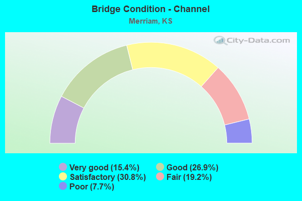
- Bridge Condition - Channel
- 15.4%Very good
- 26.9%Good
- 30.8%Satisfactory
- 19.2%Fair
- 7.7%Poor
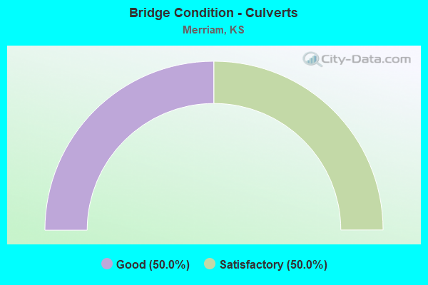
- Bridge Condition - Culverts
- 50.0%Good
- 50.0%Satisfactory
Find on map >> Show street view
Structure Number: 8009, Location: 1.5W 3.5N OF BENTON (Lat: 37.846944, Lng: -97.133889), Route carried "on" structure: County highway 72, Year Built: 1938, Year Reconstructed: 1950, Status: Open, Structure Length: 0.85m (2.79ft), Average Daily Traffic: 1,330 (year 2018), Truck Traffic: 4%, Average Future Daily Traffic: 1,223 (year 2040), Design Load: H 15, Features Intersected: PRAIRIE CREEK, Facility Carried by Structure: NW Butler Rd
Minimum Vertical Clearance: 30.47m (99.97ft), Kilometerpoint: 0.000, Lanes on structure: 2, Owner: County Highway Agency, Approaching Roadway Width: 7.3m (24.0ft), Material/Design: Concrete, Design/Construction: Tee Beam, Number Of Spans In Main Unit: 1, Length of Maximum Span: 7.6m (24.9ft), Curb-To-Curb Width: 9.1m (29.9ft), Out-to-Out Width: 9.4m (30.8ft)
Condition: Deck: Fair, Superstructure: Fair, Substructure: Serious, Channel: Poor, Operating Rating: 34.4 metric tons, Method Used To Determine Operating Rating: Load Factor (LF), Inventory Rating: 20.6 metric tons, Method Used To Determine Inventory Rating: Load Factor (LF), Structural Evaluation: High priority of corrective action, Deck Geometry: Somewhat better than minimum adequacy, Waterway Adequacy: Equal to present minimum criteria, Approach Roadway Alignment: Equal to present desirable criteria, Length Of Structure Improvement: 1.07m (3.51ft), Designated Inspection Frequency: Every 12 months, Inspection Date: Febuary 2021, Bridge Improvement Cost: $120,000, Roadway Improvement Cost: $20,000, Total Project Cost: $180,000, Deck Structure Type: Concrete Cast-file-Place, Wearing Surface/Protective System: Wearing Surface: Bituminous
Find on map >> Show street view
Structure Number: 801, Location: 1.5W 4.2N OF BENTON (Lat: 37.855619, Lng: -97.133856), Route carried "on" structure: County highway 72, Year Built: 1987, Status: Open, Structure Length: 5.24m (17.19ft), Average Daily Traffic: 1,330 (year 2018), Truck Traffic: 4%, Average Future Daily Traffic: 1,223 (year 2037), Features Intersected: WILDCAT CREEK, Facility Carried by Structure: NW Butler Rd
Minimum Vertical Clearance: 30.47m (99.97ft), Kilometerpoint: 0.000, Lanes on structure: 2, Owner: County Highway Agency, Approaching Roadway Width: 7.3m (24.0ft), Material/Design: Steel continuous, Design/Construction: Stringer/Multi-beam, Number Of Spans In Main Unit: 3, Length of Maximum Span: 20.1m (65.9ft), Curb-To-Curb Width: 9.1m (29.9ft), Out-to-Out Width: 9.8m (32.2ft)
Condition: Deck: Very good, Superstructure: Very good, Substructure: Very good, Channel: Good, Operating Rating: 54.4 metric tons, Method Used To Determine Operating Rating: Load Factor (LF), Inventory Rating: 32.6 metric tons, Method Used To Determine Inventory Rating: Load Factor (LF), Structural Evaluation: Equal to present desirable criteria, Deck Geometry: Somewhat better than minimum adequacy, Waterway Adequacy: Equal to present desirable criteria, Approach Roadway Alignment: Equal to present desirable criteria, Designated Inspection Frequency: Every 24 months, Inspection Date: Febuary 2021, Deck Structure Type: Concrete Cast-file-Place, Wearing Surface/Protective System: Wearing Surface: Monolithic Concrete
Find on map >> Show street view
Structure Number: 8036, Location: 7.0W 1.1S OF LATHAM (Lat: 37.518600, Lng: -96.770392), Route carried "on" structure: County highway 78, Year Built: 1928, Status: Open, Structure Length: 1.32m (4.33ft), Average Daily Traffic: 345 (year 2018), Truck Traffic: 1%, Average Future Daily Traffic: 290 (year 2040), Features Intersected: N. BRANCH ROCK CREEK, Facility Carried by Structure: SE COLE CREEK RD
Minimum Vertical Clearance: 30.47m (99.97ft), Kilometerpoint: 0.000, Lanes on structure: 2, Owner: County Highway Agency, Approaching Roadway Width: 4.5m (14.8ft), Material/Design: Concrete, Design/Construction: Tee Beam, Number Of Spans In Main Unit: 1, Length of Maximum Span: 12.2m (40.0ft), Curb-To-Curb Width: 6.1m (20.0ft), Out-to-Out Width: 7.7m (25.3ft)
Condition: Deck: Satisfactory, Superstructure: Fair, Substructure: Good, Channel: Satisfactory, Operating Rating: 41.1 metric tons, Method Used To Determine Operating Rating: Load Factor (LF), Inventory Rating: 24.5 metric tons, Method Used To Determine Inventory Rating: Load Factor (LF), Structural Evaluation: Somewhat better than minimum adequacy, Deck Geometry: Meets minimum limits, Waterway Adequacy: Equal to present minimum criteria, Approach Roadway Alignment: Equal to present desirable criteria, Designated Inspection Frequency: Every 24 months, Inspection Date: Febuary 2021, Deck Structure Type: Concrete Cast-file-Place, Wearing Surface/Protective System: Wearing Surface: Monolithic Concrete
Find on map >> Show street view
Structure Number: 9045, Location: 5.2E 0.4S OF CEDAR POINT (Lat: 38.254275, Lng: -96.728072), Route carried "on" structure: County highway 1076, Year Built: 1934, Status: Posted for load, Structure Length: 0.64m (2.10ft), Average Daily Traffic: 30 (year 2014), Average Future Daily Traffic: 36 (year 2039), Features Intersected: TRIB. TO COYNE CREEK
Minimum Vertical Clearance: 30.47m (99.97ft), Kilometerpoint: 0.000, Lanes on structure: 2, Owner: County Highway Agency, Approaching Roadway Width: 6.7m (22.0ft), Material/Design: Concrete, Design/Construction: Culvert, Number Of Spans In Main Unit: 2, Length of Maximum Span: 3.0m (9.8ft), Curb-To-Curb Width: 7.9m (25.9ft), Out-to-Out Width: 8.7m (28.5ft)
Condition: Channel: Fair, Culverts: Good, Operating Rating: 24.3 metric tons, Method Used To Determine Operating Rating: Allowable Stress (AS), Inventory Rating: 20.7 metric tons, Method Used To Determine Inventory Rating: Allowable Stress (AS), Structural Evaluation: Equal to present minimum criteria, Deck Geometry: Equal to present minimum criteria, Waterway Adequacy: Equal to present minimum criteria, Approach Roadway Alignment: Better than present minimum criteria, Designated Inspection Frequency: Every 24 months, Inspection Date: March 2020
Find on map >> Show street view
Structure Number: 9046, Location: 5.0E 0.3N OF CEDAR POINT (Lat: 38.265572, Lng: -96.728186), Route carried "on" structure: County highway 1076, Year Built: 1964, Status: Posted for load, Structure Length: 2.85m (9.35ft), Average Daily Traffic: 45 (year 2014), Average Future Daily Traffic: 54 (year 2039), Design Load: H 15, Features Intersected: COYNE CREEK
Minimum Vertical Clearance: 30.47m (99.97ft), Kilometerpoint: 0.000, Lanes on structure: 2, Owner: County Highway Agency, Approaching Roadway Width: 7.3m (24.0ft), Material/Design: Concrete continuous, Design/Construction: Tee Beam, Number Of Spans In Main Unit: 3, Length of Maximum Span: 10.7m (35.1ft), Curb-To-Curb Width: 7.3m (24.0ft), Out-to-Out Width: 8.0m (26.2ft)
Condition: Deck: Satisfactory, Superstructure: Good, Substructure: Satisfactory, Channel: Fair, Operating Rating: 34.7 metric tons, Method Used To Determine Operating Rating: Allowable Stress (AS), Inventory Rating: 20.8 metric tons, Method Used To Determine Inventory Rating: Allowable Stress (AS), Structural Evaluation: Equal to present minimum criteria, Deck Geometry: Equal to present minimum criteria, Waterway Adequacy: Better than present minimum criteria, Approach Roadway Alignment: Better than present minimum criteria, Designated Inspection Frequency: Every 24 months, Inspection Date: March 2020, Other Special Inspection Date: January 2020, Deck Structure Type: Concrete Cast-file-Place, Wearing Surface/Protective System: Wearing Surface: Gravel
Find on map >> Show street view
Structure Number: 10013, Location: 1.4E OF HEWINS (Lat: 37.036442, Lng: -96.373975), Route carried "on" structure: County highway 96, Year Built: 1989, Status: Open, Structure Length: 8.63m (28.31ft), Average Daily Traffic: 39 (year 2016), Truck Traffic: 5%, Average Future Daily Traffic: 45 (year 2041), Design Load: HS 20, Features Intersected: CANEY RIVER
Minimum Vertical Clearance: 30.47m (99.97ft), Kilometerpoint: 0.000, Lanes on structure: 2, Owner: County Highway Agency, Approaching Roadway Width: 5.4m (17.7ft), Skew: 2 degrees, Material/Design: Prestressed concrete continuous, Design/Construction: Stringer/Multi-beam, Number Of Spans In Main Unit: 3, Length of Maximum Span: 28.7m (94.2ft), Curb-To-Curb Width: 7.9m (25.9ft), Out-to-Out Width: 8.5m (27.9ft)
Condition: Deck: Good, Superstructure: Good, Substructure: Good, Channel: Good, Operating Rating: 64.1 metric tons, Method Used To Determine Operating Rating: Load Factor (LF), Inventory Rating: 36.5 metric tons, Method Used To Determine Inventory Rating: Load Factor (LF), Structural Evaluation: Better than present minimum criteria, Deck Geometry: Equal to present minimum criteria, Waterway Adequacy: Equal to present desirable criteria, Approach Roadway Alignment: Equal to present minimum criteria, Designated Inspection Frequency: Every 24 months, Inspection Date: July 2021, Deck Structure Type: Concrete Cast-file-Place
Find on map >> Show street view
Structure Number: 2703, Location: 0.6N 2.4E OF HOLYROOD (Lat: 38.594361, Lng: -98.370722), Route carried "on" structure: County highway 242, Year Built: 1972, Status: Posted for load, Structure Length: 1.01m (3.31ft), Average Daily Traffic: 65 (year 2017), Truck Traffic: 10%, Average Future Daily Traffic: 80 (year 2040), Design Load: H 20, Features Intersected: TRIB. TO PLUM CREEK, Facility Carried by Structure: T Road
Minimum Vertical Clearance: 30.47m (99.97ft), Kilometerpoint: 0.000, Lanes on structure: 2, Owner: County Highway Agency, Approaching Roadway Width: 7.9m (25.9ft), Skew: 3 degrees, Material/Design: Concrete, Design/Construction: Culvert, Number Of Spans In Main Unit: 2, Length of Maximum Span: 4.9m (16.1ft), Curb or Sidewalk Widths: Left: 0.4m (1.3ft), Right: 0.4m (1.3ft), Curb-To-Curb Width: 9.8m (32.2ft), Out-to-Out Width: 10.8m (35.4ft)
Condition: Channel: Satisfactory, Culverts: Good, Operating Rating: 31.8 metric tons, Method Used To Determine Operating Rating: Load Factor (LF), Inventory Rating: 19.1 metric tons, Method Used To Determine Inventory Rating: Load Factor (LF), Structural Evaluation: Somewhat better than minimum adequacy, Deck Geometry: Equal to present desirable criteria, Waterway Adequacy: Equal to present minimum criteria, Approach Roadway Alignment: Better than present minimum criteria, Bridge Posting: Required (Relationship of Operating Rating to Maximum Legal Load: 10.0 - 19.9% below), Designated Inspection Frequency: Every 24 months, Inspection Date: March 2020, Deck Structure Type: Concrete Cast-file-Place, Wearing Surface/Protective System: Wearing Surface: Gravel
Find on map >> Show street view
Structure Number: 2704, Location: 1.6W OF ELLSWORTH (Lat: 38.725692, Lng: -98.262403), Route carried "on" structure: County highway 605, Year Built: 1949, Status: Posted for load, Structure Length: 3.58m (11.75ft), Average Daily Traffic: 155 (year 2017), Truck Traffic: 10%, Average Future Daily Traffic: 185 (year 2040), Design Load: H 15, Features Intersected: TURKEY CREEK, Facility Carried by Structure: K Road
Minimum Vertical Clearance: 30.47m (99.97ft), Kilometerpoint: 0.000, Lanes on structure: 2, Owner: County Highway Agency, Approaching Roadway Width: 7.0m (23.0ft), Material/Design: Concrete continuous, Design/Construction: Slab, Number Of Spans In Main Unit: 3, Length of Maximum Span: 13.7m (44.9ft), Curb or Sidewalk Widths: Left: 0.8m (2.6ft), Right: 0.8m (2.6ft), Curb-To-Curb Width: 7.3m (24.0ft), Out-to-Out Width: 8.8m (28.9ft)
Condition: Deck: Good, Superstructure: Good, Substructure: Good, Channel: Satisfactory, Operating Rating: 12.0 metric tons, Method Used To Determine Operating Rating: Load Factor (LF), Inventory Rating: 7.2 metric tons, Method Used To Determine Inventory Rating: Load Factor (LF), Structural Evaluation: High priority of replacement, Deck Geometry: Somewhat better than minimum adequacy, Waterway Adequacy: Equal to present minimum criteria, Approach Roadway Alignment: Better than present minimum criteria, Bridge Posting: Required (Relationship of Operating Rating to Maximum Legal Load: > 39.9% below), Length Of Structure Improvement: 4.27m (14.01ft), Designated Inspection Frequency: Every 24 months, Inspection Date: March 2020, Bridge Improvement Cost: $567,000, Roadway Improvement Cost: $63,000, Total Project Cost: $630,000 ( Estimate for 2020), Deck Structure Type: Concrete Cast-file-Place, Wearing Surface/Protective System: Wearing Surface: Gravel
Find on map >> Show street view
Structure Number: 3707, Location: 4.0S 0.7E OF LAPLAND (Lat: 37.926361, Lng: -96.387500), Route carried "on" structure: County highway 1362, Year Built: 1930, Status: Posted for load, Structure Length: 3.96m (12.99ft), Average Daily Traffic: 52 (year 2006), Average Future Daily Traffic: 52 (year 2043), Design Load: HS 20, Features Intersected: EAST BRANCH FALL RIVER
Minimum Vertical Clearance: 30.47m (99.97ft), Kilometerpoint: 0.000, Lanes on structure: 2, Owner: County Highway Agency, Approaching Roadway Width: 6.0m (19.7ft), Material/Design: Concrete continuous, Design/Construction: Tee Beam, Number Of Spans In Main Unit: 4, Length of Maximum Span: 9.8m (32.2ft), Curb or Sidewalk Widths: Left: 0.5m (1.6ft), Right: 0.5m (1.6ft), Curb-To-Curb Width: 6.1m (20.0ft), Out-to-Out Width: 7.0m (23.0ft)
Condition: Deck: Satisfactory, Superstructure: Fair, Substructure: Poor, Channel: Poor, Operating Rating: 36.9 metric tons, Method Used To Determine Operating Rating: Load Factor (LF), Inventory Rating: 27.0 metric tons, Method Used To Determine Inventory Rating: Load Factor (LF), Structural Evaluation: Meets minimum limits, Deck Geometry: Somewhat better than minimum adequacy, Waterway Adequacy: Better than present minimum criteria, Approach Roadway Alignment: Equal to present desirable criteria, Length Of Structure Improvement: 14.57m (47.80ft), Designated Inspection Frequency: Every 24 months, Inspection Date: June 2021, Bridge Improvement Cost: $126,000, Roadway Improvement Cost: $48,000, Total Project Cost: $200,000, Deck Structure Type: Other, Wearing Surface/Protective System: Wearing Surface: Monolithic Concrete
Find on map >> Show street view
Structure Number: 8404, Location: S. EDGE OF PARADISE (Lat: 39.111672, Lng: -98.918564), Route carried "on" structure: County highway 917, Year Built: 1901, Status: Posted for load, Structure Length: 1.52m (4.99ft), Average Daily Traffic: 70 (year 2014), Average Future Daily Traffic: 80 (year 2040), Features Intersected: PARADISE CREEK
Minimum Vertical Clearance: 30.47m (99.97ft), Kilometerpoint: 0.000, Lanes on structure: 2, Owner: County Highway Agency, Approaching Roadway Width: 6.7m (22.0ft), Material/Design: Masonry, Design/Construction: Culvert, Number Of Spans In Main Unit: 1, Length of Maximum Span: 15.2m (49.9ft), Curb-To-Curb Width: 7.2m (23.6ft), Out-to-Out Width: 7.3m (24.0ft)
Condition: Channel: Satisfactory, Culverts: Satisfactory, Operating Rating: 79.5 metric tons, Method Used To Determine Operating Rating: Allowable Stress (AS), Inventory Rating: 79.5 metric tons, Method Used To Determine Inventory Rating: Allowable Stress (AS), Structural Evaluation: Equal to present minimum criteria, Deck Geometry: Somewhat better than minimum adequacy, Waterway Adequacy: Equal to present desirable criteria, Approach Roadway Alignment: Equal to present desirable criteria, Designated Inspection Frequency: Every 24 months, Inspection Date: March 2020, Deck Structure Type: Other, Wearing Surface/Protective System: Wearing Surface: Bituminous
Find on map >> Show street view
Structure Number: 8714, Location: 8.8W OF MULVANE (Lat: 37.476683, Lng: -97.403958), Route carried "on" structure: County highway 999, Year Built: 1975, Status: Open, Structure Length: 0.67m (2.20ft), Average Daily Traffic: 364 (year 2018), Truck Traffic: 16%, Average Future Daily Traffic: 444 (year 2038), Design Load: H 20, Features Intersected: TRIB. TO NINNESCAH RIVER
Minimum Vertical Clearance: 30.47m (99.97ft), Kilometerpoint: 0.000, Lanes on structure: 2, Owner: County Highway Agency, Approaching Roadway Width: 6.4m (21.0ft), Material/Design: Concrete, Design/Construction: Culvert, Number Of Spans In Main Unit: 2, Length of Maximum Span: 3.0m (9.8ft), Curb-To-Curb Width: 10.9m (35.8ft), Out-to-Out Width: 11.6m (38.1ft)
Condition: Channel: Satisfactory, Culverts: Satisfactory, Operating Rating: 27.9 metric tons, Method Used To Determine Operating Rating: Load Factor (LF), Inventory Rating: 22.5 metric tons, Method Used To Determine Inventory Rating: Load Factor (LF), Structural Evaluation: Equal to present minimum criteria, Deck Geometry: Better than present minimum criteria, Waterway Adequacy: Equal to present minimum criteria, Approach Roadway Alignment: Equal to present minimum criteria, Designated Inspection Frequency: Every 24 months, Inspection Date: July 2020, Deck Structure Type: Concrete Cast-file-Place, Wearing Surface/Protective System: Wearing Surface: Bituminous
Find on map >> Show street view
Structure Number: 9604, Location: 1.0S OF ANSON (Lat: 37.351725, Lng: -97.530408), Route carried "on" structure: County highway 642, Year Built: 1965, Status: Posted for load, Structure Length: 2.74m (8.99ft), Average Daily Traffic: 510 (year 2013), Truck Traffic: 1%, Average Future Daily Traffic: 371 (year 2041), Features Intersected: TRIB. TO SLATE CREEK
Minimum Vertical Clearance: 30.47m (99.97ft), Kilometerpoint: 0.000, Lanes on structure: 2, Owner: County Highway Agency, Approaching Roadway Width: 7.8m (25.6ft), Skew: 3 degrees, Material/Design: Steel continuous, Design/Construction: Stringer/Multi-beam, Number Of Spans In Main Unit: 3, Length of Maximum Span: 9.1m (29.9ft), Curb-To-Curb Width: 7.9m (25.9ft), Out-to-Out Width: 7.9m (25.9ft)
Condition: Deck: Fair, Superstructure: Fair, Substructure: Satisfactory, Channel: Satisfactory, Operating Rating: 30.5 metric tons, Method Used To Determine Operating Rating: Load Factor (LF), Inventory Rating: 18.2 metric tons, Method Used To Determine Inventory Rating: Load Factor (LF), Structural Evaluation: Somewhat better than minimum adequacy, Deck Geometry: Somewhat better than minimum adequacy, Waterway Adequacy: Equal to present minimum criteria, Approach Roadway Alignment: Equal to present desirable criteria, Bridge Posting: Required (Relationship of Operating Rating to Maximum Legal Load: 0.1 - 9.9% below), Designated Inspection Frequency: Every 24 months, Inspection Date: June 2021, Deck Structure Type: Concrete Cast-file-Place, Wearing Surface/Protective System: Wearing Surface: Bituminous
Find on map >> Show street view
Structure Number: 9605, Location: 4.0S 0.1W OF DALTON (Lat: 37.210392, Lng: -97.275683), Route carried "on" structure: County highway 644, Year Built: 1992, Status: Posted for load, Structure Length: 1.77m (5.81ft), Average Daily Traffic: 280 (year 2013), Truck Traffic: 1%, Average Future Daily Traffic: 452 (year 2041), Design Load: HS 20, Features Intersected: TRIB. TO SLATE CREEK
Minimum Vertical Clearance: 30.47m (99.97ft), Kilometerpoint: 0.000, Lanes on structure: 2, Owner: County Highway Agency, Approaching Roadway Width: 8.5m (27.9ft), Material/Design: Steel continuous, Design/Construction: Stringer/Multi-beam, Number Of Spans In Main Unit: 2, Length of Maximum Span: 8.8m (28.9ft), Curb-To-Curb Width: 8.5m (27.9ft), Out-to-Out Width: 9.1m (29.9ft)
Condition: Deck: Good, Superstructure: Satisfactory, Substructure: Satisfactory, Channel: Satisfactory, Operating Rating: 29.6 metric tons, Method Used To Determine Operating Rating: Load Factor (LF), Inventory Rating: 17.7 metric tons, Method Used To Determine Inventory Rating: Load Factor (LF), Structural Evaluation: Somewhat better than minimum adequacy, Deck Geometry: Equal to present minimum criteria, Waterway Adequacy: Equal to present minimum criteria, Approach Roadway Alignment: Equal to present desirable criteria, Bridge Posting: Required (Relationship of Operating Rating to Maximum Legal Load: 0.1 - 9.9% below), Designated Inspection Frequency: Every 24 months, Inspection Date: May 2021, Deck Structure Type: Concrete Cast-file-Place
Find on map >> Show street view
Structure Number: 418600462724003, Location: 0.6 MILES WEST OF I-35 (Lat: 39.014739, Lng: -94.703681), Route carried "on" structure: City street 2724, Year Built: 1936, Year Reconstructed: 2010, Status: Open, Structure Length: 2.12m (6.96ft), Average Daily Traffic: 42,800 (year 2004), Truck Traffic: 7%, Average Future Daily Traffic: 44,000 (year 2043), Design Load: HS 20, Features Intersected: TURKEY CREEK TRIBUTARY
Minimum Vertical Clearance: 30.47m (99.97ft), Kilometerpoint: 0.000, Lanes on structure: 8, Owner: City or Municipal Highway Agency, Approaching Roadway Width: 32.4m (106.3ft), Skew: 20 degrees, Material/Design: Concrete, Design/Construction: Culvert, Number Of Spans In Main Unit: 7, Length of Maximum Span: 3.0m (9.8ft)
Condition: Channel: Fair, Culverts: Satisfactory, Operating Rating: 36.6 metric tons, Method Used To Determine Operating Rating: Load Factor (LF), Inventory Rating: 21.9 metric tons, Method Used To Determine Inventory Rating: Load Factor (LF), Structural Evaluation: Somewhat better than minimum adequacy, Waterway Adequacy: Equal to present minimum criteria, Approach Roadway Alignment: Equal to present desirable criteria, Designated Inspection Frequency: Every 24 months, Inspection Date: November 2021
Find on map >> Show street view
Structure Number: 418600462724004, Location: 0.5 MILES WEST OF I-35 (Lat: 39.014850, Lng: -94.700778), Route carried "on" structure: City street 2724, Year Built: 1936, Year Reconstructed: 1971, Status: Open, Structure Length: 1.89m (6.20ft), Average Daily Traffic: 42,800 (year 2004), Truck Traffic: 7%, Average Future Daily Traffic: 44,000 (year 2043), Design Load: H 15, Features Intersected: TURKEY CREEK
Minimum Vertical Clearance: 30.47m (99.97ft), Kilometerpoint: 0.000, Lanes on structure: 7, Owner: City or Municipal Highway Agency, Approaching Roadway Width: 27.4m (89.9ft), Skew: 20 degrees, Material/Design: Concrete, Design/Construction: Culvert, Number Of Spans In Main Unit: 4, Length of Maximum Span: 4.6m (15.1ft), Curb-To-Curb Width: 27.4m (89.9ft), Out-to-Out Width: 42.1m (138.1ft)
Condition: Channel: Fair, Culverts: Satisfactory, Operating Rating: 71.5 metric tons, Method Used To Determine Operating Rating: Load Factor (LF), Inventory Rating: 42.7 metric tons, Method Used To Determine Inventory Rating: Load Factor (LF), Structural Evaluation: Equal to present minimum criteria, Deck Geometry: Somewhat better than minimum adequacy, Waterway Adequacy: Equal to present minimum criteria, Approach Roadway Alignment: Equal to present desirable criteria, Length Of Structure Improvement: 1.89m (6.20ft), Designated Inspection Frequency: Every 24 months, Inspection Date: November 2021, Bridge Improvement Cost: $100,000, Roadway Improvement Cost: $50,000, Total Project Cost: $155,000, Deck Structure Type: Concrete Cast-file-Place, Wearing Surface/Protective System: Wearing Surface: Bituminous
Find on map >> Show street view
Structure Number: 418600462724005, Location: 0.2 MILES WEST OF I-35 (Lat: 39.014897, Lng: -94.696197), Route carried "on" structure: City street 2724, Year Built: 1936, Year Reconstructed: 2017, Status: Open, Structure Length: 9.42m (30.91ft), Average Daily Traffic: 42,800 (year 2004), Truck Traffic: 7%, Average Future Daily Traffic: 44,000 (year 2043), Design Load: HS 20, Features Intersected: B.N. R.R. & MERRIAM DR.
Minimum Vertical Clearance: 30.47m (99.97ft), Kilometerpoint: 0.000, Lanes on structure: 8, Lanes under structure: 2, Owner: City or Municipal Highway Agency, Approaching Roadway Width: 21.9m (71.9ft), Skew: 12 degrees, Material/Design: Steel continuous, Design/Construction: Stringer/Multi-beam, Number Of Spans In Main Unit: 5, Length of Maximum Span: 22.9m (75.1ft), Curb-To-Curb Width: 32.3m (106.0ft), Out-to-Out Width: 33.1m (108.6ft)
Condition: Deck: Good, Superstructure: Very good, Substructure: Good, Operating Rating: 33.6 metric tons, Method Used To Determine Operating Rating: Load Factor (LF), Inventory Rating: 19.9 metric tons, Method Used To Determine Inventory Rating: Load Factor (LF), Structural Evaluation: Somewhat better than minimum adequacy, Deck Geometry: Somewhat better than minimum adequacy, Underclear: Meets minimum limits, Approach Roadway Alignment: Equal to present desirable criteria, Length Of Structure Improvement: 1.00m (3.28ft), Designated Inspection Frequency: Every 24 months, Inspection Date: November 2021, Bridge Improvement Cost: $50,000, Roadway Improvement Cost: $1,000, Total Project Cost: $56,000, Deck Structure Type: Concrete Cast-file-Place, Wearing Surface/Protective System: Wearing Surface: Epoxy Overlay, Deck Protection: Epoxy Coated Reinforcing
Find on map >> Show street view
Structure Number: 418600462865006, Location: 400FT N OF 57TH ST (Lat: 39.027100, Lng: -94.693331), Route carried "on" structure: City street 2865, Year Built: 1954, Year Reconstructed: 1984, Status: Open, Structure Length: 2.32m (7.61ft), Average Daily Traffic: 10,800 (year 2004), Truck Traffic: 12%, Average Future Daily Traffic: 10,800 (year 2043), Design Load: H 20, Features Intersected: TURKEY CREEK
Minimum Vertical Clearance: 30.47m (99.97ft), Kilometerpoint: 0.000, Lanes on structure: 4, Owner: City or Municipal Highway Agency, Approaching Roadway Width: 14.3m (46.9ft), Material/Design: Concrete continuous, Design/Construction: Slab, Number Of Spans In Main Unit: 3, Length of Maximum Span: 7.6m (24.9ft), Curb or Sidewalk Widths: Left: 3.2m (10.5ft), Right: 3.2m (10.5ft), Curb-To-Curb Width: 14.3m (46.9ft), Out-to-Out Width: 21.3m (69.9ft)
Condition: Deck: Satisfactory, Superstructure: Satisfactory, Substructure: Satisfactory, Channel: Satisfactory, Operating Rating: 40.4 metric tons, Method Used To Determine Operating Rating: Load Factor (LF), Inventory Rating: 24.1 metric tons, Method Used To Determine Inventory Rating: Load Factor (LF), Structural Evaluation: Somewhat better than minimum adequacy, Deck Geometry: High priority of replacement, Waterway Adequacy: Equal to present minimum criteria, Approach Roadway Alignment: Equal to present desirable criteria, Length Of Structure Improvement: 2.32m (7.61ft), Designated Inspection Frequency: Every 24 months, Inspection Date: November 2021, Bridge Improvement Cost: $187,000, Roadway Improvement Cost: $18,000, Total Project Cost: $280,000, Deck Structure Type: Concrete Cast-file-Place, Wearing Surface/Protective System: Wearing Surface: Low Slump Concrete
Find on map >> Show street view
Structure Number: 418600462865007, Location: 0.13MI N OF 53RD ST (Lat: 39.034553, Lng: -94.690167), Route carried "on" structure: City street 2865, Year Built: 1985, Status: Open, Structure Length: 1.01m (3.31ft), Average Daily Traffic: 10,800 (year 2004), Truck Traffic: 12%, Average Future Daily Traffic: 11,000 (year 2043), Design Load: H 20, Features Intersected: TURKEY CREEK TRIBUTARY
Minimum Vertical Clearance: 6.09m (19.98ft), Kilometerpoint: 0.000, Lanes on structure: 3, Owner: City or Municipal Highway Agency, Approaching Roadway Width: 11.8m (38.7ft), Skew: 5 degrees, Material/Design: Concrete, Design/Construction: Culvert, Number Of Spans In Main Unit: 2, Length of Maximum Span: 4.8m (15.7ft), Curb or Sidewalk Widths: Left: 1.2m (3.9ft), Right: 1.2m (3.9ft)
Condition: Channel: Good, Culverts: Satisfactory, Operating Rating: 54.4 metric tons, Method Used To Determine Operating Rating: Field evaluation and documented engineering judgment, Inventory Rating: 32.7 metric tons, Method Used To Determine Inventory Rating: Field evaluation and documented engineering judgment, Structural Evaluation: Equal to present minimum criteria, Waterway Adequacy: Equal to present minimum criteria, Approach Roadway Alignment: Equal to present desirable criteria, Designated Inspection Frequency: Every 24 months, Inspection Date: November 2021
Find on map >> Show street view
Structure Number: 418600462865008, Location: 150FT S OF JOHNSON DRIVE (Lat: 39.021364, Lng: -94.694233), Route carried "on" structure: City street 2865, Year Built: 1954, Year Reconstructed: 1988, Status: Open, Structure Length: 0.70m (2.30ft), Average Daily Traffic: 10,800 (year 2004), Truck Traffic: 12%, Average Future Daily Traffic: 11,000 (year 2043), Design Load: H 20, Features Intersected: TURKEY CREEK TRIB.
Minimum Vertical Clearance: 30.47m (99.97ft), Kilometerpoint: 0.000, Lanes on structure: 2, Owner: City or Municipal Highway Agency, Approaching Roadway Width: 12.1m (39.7ft), Material/Design: Concrete, Design/Construction: Culvert, Number Of Spans In Main Unit: 3, Length of Maximum Span: 2.1m (6.9ft), Curb or Sidewalk Widths: Left: 1.2m (3.9ft), Right: 1.2m (3.9ft)
Condition: Channel: Very good, Culverts: Satisfactory, Operating Rating: 54.4 metric tons, Method Used To Determine Operating Rating: Field evaluation and documented engineering judgment, Inventory Rating: 32.7 metric tons, Method Used To Determine Inventory Rating: Field evaluation and documented engineering judgment, Structural Evaluation: Equal to present minimum criteria, Waterway Adequacy: Equal to present desirable criteria, Approach Roadway Alignment: Equal to present desirable criteria, Designated Inspection Frequency: Every 24 months, Inspection Date: November 2021
Find on map >> Show street view
Structure Number: 418600462865009, Location: 100FT S OF 70TH ST (Lat: 39.001647, Lng: -94.705103), Route carried "on" structure: City street 2865, Year Built: 2001, Status: Open, Structure Length: 0.75m (2.46ft), Average Daily Traffic: 10,800 (year 2004), Average Future Daily Traffic: 11,000 (year 2043), Design Load: H 20, Features Intersected: TURKEY CREEK TRIBUTARY, Facility Carried by Structure: Switzer Rd.
Minimum Vertical Clearance: 5.48m (17.98ft), Kilometerpoint: 0.000, Lanes on structure: 2, Owner: City or Municipal Highway Agency, Approaching Roadway Width: 8.6m (28.2ft), Skew: 2 degrees, Material/Design: Concrete, Design/Construction: Culvert, Number Of Spans In Main Unit: 3, Length of Maximum Span: 2.3m (7.5ft), Curb or Sidewalk Widths: Left: 0.0m, Right: 1.8m (5.9ft)
Condition: Channel: Good, Culverts: Good, Operating Rating: 54.4 metric tons, Method Used To Determine Operating Rating: Field evaluation and documented engineering judgment, Inventory Rating: 32.7 metric tons, Method Used To Determine Inventory Rating: Field evaluation and documented engineering judgment, Structural Evaluation: Better than present minimum criteria, Waterway Adequacy: Better than present minimum criteria, Approach Roadway Alignment: Equal to present desirable criteria, Designated Inspection Frequency: Every 24 months, Inspection Date: November 2021
Find on map >> Show street view
Structure Number: 518600460000005, Location: 0.1N OF 75TH. ST. (Lat: 38.993597, Lng: -94.700842), Route carried "on" structure: City street , Year Built: 1985, Status: Open, Structure Length: 3.11m (10.20ft), Average Daily Traffic: 2,000 (year 2004), Truck Traffic: 39%, Average Future Daily Traffic: 2,500 (year 2043), Design Load: HS 20, Features Intersected: TURKEY CREEK, Facility Carried by Structure: WEST FRONTAGE RD.
Minimum Vertical Clearance: 30.47m (99.97ft), Kilometerpoint: 0.000, Lanes on structure: 2, Owner: City or Municipal Highway Agency, Approaching Roadway Width: 8.5m (27.9ft), Material/Design: Concrete continuous, Design/Construction: Slab, Number Of Spans In Main Unit: 3, Length of Maximum Span: 12.2m (40.0ft), Curb-To-Curb Width: 8.5m (27.9ft), Out-to-Out Width: 9.1m (29.9ft)
Condition: Deck: Satisfactory, Superstructure: Satisfactory, Substructure: Satisfactory, Channel: Fair, Operating Rating: 50.3 metric tons, Method Used To Determine Operating Rating: Load Factor (LF), Inventory Rating: 30.0 metric tons, Method Used To Determine Inventory Rating: Load Factor (LF), Structural Evaluation: Equal to present minimum criteria, Deck Geometry: Somewhat better than minimum adequacy, Waterway Adequacy: Equal to present minimum criteria, Approach Roadway Alignment: Equal to present desirable criteria, Designated Inspection Frequency: Every 24 months, Inspection Date: November 2021, Deck Structure Type: Concrete Cast-file-Place, Wearing Surface/Protective System: Deck Protection: Epoxy Coated Reinforcing
Find on map >> Show street view
Structure Number: 518600460000006, Location: 550FT NORTH OF W 53RD ST (Lat: 39.034611, Lng: -94.701206), Route carried "on" structure: City street 18895, Year Built: 2014, Status: Open, Structure Length: 0.89m (2.92ft), Average Daily Traffic: 250 (year 2014), Truck Traffic: 1%, Average Future Daily Traffic: 300 (year 2043), Design Load: HL 93, Features Intersected: DRAINAGE DITCH, Facility Carried by Structure: FARLEY LANE
Minimum Vertical Clearance: 30.47m (99.97ft), Kilometerpoint: 0.000, Lanes on structure: 2, Owner: City or Municipal Highway Agency, Approaching Roadway Width: 7.9m (25.9ft), Skew: 1 degrees, Material/Design: Concrete, Design/Construction: Culvert, Number Of Spans In Main Unit: 2, Length of Maximum Span: 4.3m (14.1ft)
Condition: Channel: Very good, Culverts: Good, Operating Rating: 62.5 metric tons, Method Used To Determine Operating Rating: Load and Resistance Factor Rating (LRFR) rating reported by rating factor(RF) method using HL-93 loadings, Inventory Rating: 48.3 metric tons, Method Used To Determine Inventory Rating: Load and Resistance Factor Rating (LRFR) rating reported by rating factor(RF) method using HL-93 loadings, Structural Evaluation: Better than present minimum criteria, Waterway Adequacy: Equal to present desirable criteria, Approach Roadway Alignment: Equal to present desirable criteria, Designated Inspection Frequency: Every 24 months, Inspection Date: November 2021
Find on map >> Show street view
Structure Number: 518600460000007, Location: 700FT NORTH OF W 53RD ST (Lat: 39.035094, Lng: -94.698228), Route carried "on" structure: City street 20335, Year Built: 2014, Status: Open, Structure Length: 1.31m (4.30ft), Average Daily Traffic: 250 (year 2014), Truck Traffic: 1%, Average Future Daily Traffic: 300 (year 2043), Design Load: HL 93, Features Intersected: DRAINAGE DITCH, Facility Carried by Structure: KNOX AVE
Minimum Vertical Clearance: 30.47m (99.97ft), Kilometerpoint: 0.000, Lanes on structure: 2, Owner: City or Municipal Highway Agency, Approaching Roadway Width: 10.9m (35.8ft), Skew: 4 degrees, Material/Design: Concrete, Design/Construction: Culvert, Number Of Spans In Main Unit: 1, Length of Maximum Span: 13.1m (43.0ft), Curb or Sidewalk Widths: Left: 0.0m, Right: 1.2m (3.9ft)
Condition: Channel: Good, Culverts: Good, Operating Rating: 54.4 metric tons, Method Used To Determine Operating Rating: Field evaluation and documented engineering judgment, Inventory Rating: 32.7 metric tons, Method Used To Determine Inventory Rating: Field evaluation and documented engineering judgment, Structural Evaluation: Better than present minimum criteria, Waterway Adequacy: Equal to present desirable criteria, Approach Roadway Alignment: Equal to present desirable criteria, Designated Inspection Frequency: Every 24 months, Inspection Date: November 2021
Find on map >> Show street view
Structure Number: 518600460000008, Location: 160' S. of 70th Street (Lat: 39.002556, Lng: -94.701122), Route carried "on" structure: City street 5228, Year Built: 2015, Status: Open, Structure Length: 0.61m (2.00ft), Average Daily Traffic: 1,000 (year 2005), Truck Traffic: 2%, Average Future Daily Traffic: 1,200 (year 2043), Design Load: HL 93, Features Intersected: Meyer Creek, Facility Carried by Structure: 70th Terrace
Minimum Vertical Clearance: 30.47m (99.97ft), Kilometerpoint: 0.000, Lanes on structure: 2, Owner: City or Municipal Highway Agency, Approaching Roadway Width: 8.2m (26.9ft), Material/Design: Concrete, Design/Construction: Culvert, Number Of Spans In Main Unit: 1, Length of Maximum Span: 6.1m (20.0ft), Curb or Sidewalk Widths: Left: 1.2m (3.9ft), Right: 0.0m
Condition: Channel: Very good, Culverts: Good, Operating Rating: 54.4 metric tons, Method Used To Determine Operating Rating: Field evaluation and documented engineering judgment, Inventory Rating: 32.7 metric tons, Method Used To Determine Inventory Rating: Field evaluation and documented engineering judgment, Structural Evaluation: Better than present minimum criteria, Waterway Adequacy: Equal to present desirable criteria, Approach Roadway Alignment: Equal to present desirable criteria, Designated Inspection Frequency: Every 24 months, Inspection Date: November 2021
Find on map >> Show street view
Structure Number: 51860046T.318.5, Location: 0.3W OF I-35 (Lat: 39.007564, Lng: -94.699072), Route carried "on" structure: City street , Year Built: 1986, Status: Open, Structure Length: 3.11m (10.20ft), Average Daily Traffic: 14,500 (year 2004), Truck Traffic: 3%, Average Future Daily Traffic: 14,500 (year 2043), Design Load: HS 20, Features Intersected: TURKEY CREEK, Facility Carried by Structure: 67TH. STREET
Minimum Vertical Clearance: 6.09m (19.98ft), Kilometerpoint: 0.000, Lanes on structure: 3, Owner: City or Municipal Highway Agency, Approaching Roadway Width: 14.5m (47.6ft), Material/Design: Concrete continuous, Design/Construction: Slab, Number Of Spans In Main Unit: 3, Length of Maximum Span: 12.2m (40.0ft), Curb or Sidewalk Widths: Left: 0.0m, Right: 1.5m (4.9ft), Curb-To-Curb Width: 15.8m (51.8ft), Out-to-Out Width: 18.1m (59.4ft)
Condition: Deck: Good, Superstructure: Good, Substructure: Good, Channel: Very good, Operating Rating: 54.8 metric tons, Method Used To Determine Operating Rating: Load Factor (LF), Inventory Rating: 32.9 metric tons, Method Used To Determine Inventory Rating: Load Factor (LF), Structural Evaluation: Better than present minimum criteria, Deck Geometry: Better than present minimum criteria, Waterway Adequacy: Equal to present desirable criteria, Approach Roadway Alignment: Equal to present desirable criteria, Designated Inspection Frequency: Every 24 months, Inspection Date: November 2021, Deck Structure Type: Concrete Cast-file-Place, Wearing Surface/Protective System: Wearing Surface: Monolithic Concrete, Membrane: Epoxy, Deck Protection: Epoxy Coated Reinforcing
Find on map >> Show street view
Structure Number: 51860046T.519.5, Location: 0.2W OF I-35 (Lat: 39.022206, Lng: -94.694653), Route carried "on" structure: City street , Year Built: 1981, Year Reconstructed: 2014, Status: Open, Structure Length: 4.60m (15.09ft), Average Daily Traffic: 17,000 (year 2013), Truck Traffic: 3%, Average Future Daily Traffic: 19,000 (year 2043), Design Load: HL 93, Features Intersected: TURKEY CREEK, Facility Carried by Structure: JOHNSON DRIVE
Minimum Vertical Clearance: 30.47m (99.97ft), Kilometerpoint: 0.000, Lanes on structure: 5, Owner: City or Municipal Highway Agency, Approaching Roadway Width: 14.6m (47.9ft), Material/Design: Steel continuous, Design/Construction: Stringer/Multi-beam, Number Of Spans In Main Unit: 3, Length of Maximum Span: 15.2m (49.9ft), Curb or Sidewalk Widths: Left: 1.5m (4.9ft), Right: 1.5m (4.9ft), Curb-To-Curb Width: 18.6m (61.0ft), Out-to-Out Width: 23.0m (75.5ft)
Condition: Deck: Good, Superstructure: Very good, Substructure: Very good, Channel: Good, Operating Rating: 92.1 metric tons, Method Used To Determine Operating Rating: Load Factor (LF), Inventory Rating: 55.2 metric tons, Method Used To Determine Inventory Rating: Load Factor (LF), Structural Evaluation: Equal to present desirable criteria, Deck Geometry: High priority of corrective action, Waterway Adequacy: Better than present minimum criteria, Approach Roadway Alignment: Equal to present desirable criteria, Designated Inspection Frequency: Every 24 months, Inspection Date: November 2021, Deck Structure Type: Concrete Cast-file-Place, Wearing Surface/Protective System: Wearing Surface: Epoxy Overlay, Deck Protection: Epoxy Coated Reinforcing
Find on map >> Show street view
Structure Number: 999903500462541, Location: JCT 75TH ST/I35 (Lat: 38.993056, Lng: -94.697778), Route carried "on" structure: City street 2760, Year Built: 1987, Status: Open, Structure Length: 10.44m (34.25ft), Average Daily Traffic: 10,458 (year 2020), Truck Traffic: 7%, Average Future Daily Traffic: 26,032 (year 2041), Design Load: HS 20, Features Intersected: I-35 HWY
Minimum Vertical Clearance: 30.47m (99.97ft), Kilometerpoint: 5.393, Lanes on structure: 2, Lanes under structure: 6, Owner: State Highway Agency, Approaching Roadway Width: 11.0m (36.1ft), Skew: 23 degrees, Material/Design: Steel continuous, Design/Construction: Stringer/Multi-beam, Number Of Spans In Main Unit: 4, Length of Maximum Span: 32.3m (106.0ft), Curb or Sidewalk Widths: Left: 1.5m (4.9ft), Right: 0.0m, Curb-To-Curb Width: 15.2m (49.9ft), Out-to-Out Width: 18.3m (60.0ft)
Condition: Deck: Very good, Superstructure: Good, Substructure: Good, Operating Rating: 66.2 metric tons, Method Used To Determine Operating Rating: Load Factor (LF), Inventory Rating: 39.9 metric tons, Method Used To Determine Inventory Rating: Load Factor (LF), Structural Evaluation: Better than present minimum criteria, Deck Geometry: Superior to present desirable criteria, Underclear: Somewhat better than minimum adequacy, Approach Roadway Alignment: Better than present minimum criteria, Length Of Structure Improvement: 34.27m (112.43ft), Designated Inspection Frequency: Every 24 months, Inspection Date: May 2020, Wearing Surface/Protective System: Wearing Surface: Epoxy Overlay, Deck Protection: Epoxy Coated Reinforcing
Find on map >> Show street view
Structure Number: 999903500462551, Location: JCT 75TH ST/I35 (Lat: 38.992778, Lng: -94.697778), Route carried "on" structure: City street 2760, Year Built: 1987, Status: Open, Structure Length: 10.44m (34.25ft), Average Daily Traffic: 10,458 (year 2020), Truck Traffic: 7%, Average Future Daily Traffic: 26,654 (year 2041), Design Load: HS 20, Features Intersected: I35 HWY,WL-EL
Minimum Vertical Clearance: 30.47m (99.97ft), Kilometerpoint: 5.374, Lanes on structure: 4, Lanes under structure: 6, Owner: State Highway Agency, Approaching Roadway Width: 11.0m (36.1ft), Skew: 23 degrees, Material/Design: Steel continuous, Design/Construction: Stringer/Multi-beam, Number Of Spans In Main Unit: 4, Length of Maximum Span: 32.3m (106.0ft), Curb-To-Curb Width: 15.2m (49.9ft), Out-to-Out Width: 16.9m (55.4ft)
Condition: Deck: Very good, Superstructure: Good, Substructure: Good, Operating Rating: 64.4 metric tons, Method Used To Determine Operating Rating: Load Factor (LF), Inventory Rating: 38.1 metric tons, Method Used To Determine Inventory Rating: Load Factor (LF), Structural Evaluation: Better than present minimum criteria, Deck Geometry: High priority of corrective action, Underclear: Somewhat better than minimum adequacy, Approach Roadway Alignment: Better than present minimum criteria, Length Of Structure Improvement: 34.27m (112.43ft), Designated Inspection Frequency: Every 24 months, Inspection Date: May 2020, Wearing Surface/Protective System: Wearing Surface: Epoxy Overlay, Deck Protection: Epoxy Coated Reinforcing
Find on map >> Show street view
Structure Number: 999903500462751, Location: JCT 67TH ST/I35 (Lat: 39.007500, Lng: -94.693611), Route carried "on" structure: Interstate 35, Year Built: 1991, Status: Open, Structure Length: 5.35m (17.55ft), Average Daily Traffic: 65,931 (year 2020), Truck Traffic: 11%, Average Future Daily Traffic: 77,322 (year 2041), Design Load: HS 20, Features Intersected: 67TH ST
Minimum Vertical Clearance: 30.47m (99.97ft), Kilometerpoint: 42.240, Lanes on structure: 4, Lanes under structure: 5, Base Highway Network: Yes, Owner: State Highway Agency, Approaching Roadway Width: 20.7m (67.9ft), Material/Design: Concrete continuous, Design/Construction: Slab, Number Of Spans In Main Unit: 4, Length of Maximum Span: 14.2m (46.6ft), Curb-To-Curb Width: 20.7m (67.9ft), Out-to-Out Width: 21.5m (70.5ft)
Condition: Deck: Good, Superstructure: Good, Substructure: Very good, Operating Rating: 59.0 metric tons, Method Used To Determine Operating Rating: Load Factor (LF), Inventory Rating: 35.4 metric tons, Method Used To Determine Inventory Rating: Load Factor (LF), Structural Evaluation: Better than present minimum criteria, Deck Geometry: Equal to present minimum criteria, Underclear: High priority of corrective action, Approach Roadway Alignment: Equal to present desirable criteria, Length Of Structure Improvement: 17.56m (57.61ft), Designated Inspection Frequency: Every 24 months, Inspection Date: May 2020, Wearing Surface/Protective System: Wearing Surface: Monolithic Concrete, Deck Protection: Epoxy Coated Reinforcing
Find on map >> Show street view
Structure Number: 999903500462761, Location: JCT 67TH ST/I35 SB (Lat: 39.007500, Lng: -94.693889), Route carried "on" structure: Interstate 35, Year Built: 1991, Status: Open, Structure Length: 5.35m (17.55ft), Average Daily Traffic: 65,931 (year 2020), Truck Traffic: 11%, Average Future Daily Traffic: 77,322 (year 2041), Design Load: HS 20, Features Intersected: 67THST
Minimum Vertical Clearance: 30.47m (99.97ft), Kilometerpoint: 42.253, Lanes on structure: 4, Lanes under structure: 4, Base Highway Network: Yes, Owner: State Highway Agency, Approaching Roadway Width: 20.7m (67.9ft), Material/Design: Concrete continuous, Design/Construction: Slab, Number Of Spans In Main Unit: 4, Length of Maximum Span: 14.2m (46.6ft), Curb-To-Curb Width: 20.7m (67.9ft), Out-to-Out Width: 21.5m (70.5ft)
Condition: Deck: Good, Superstructure: Good, Substructure: Good, Operating Rating: 59.0 metric tons, Method Used To Determine Operating Rating: Load Factor (LF), Inventory Rating: 35.4 metric tons, Method Used To Determine Inventory Rating: Load Factor (LF), Structural Evaluation: Better than present minimum criteria, Deck Geometry: Equal to present minimum criteria, Underclear: High priority of corrective action, Approach Roadway Alignment: Equal to present desirable criteria, Length Of Structure Improvement: 17.55m (57.58ft), Designated Inspection Frequency: Every 24 months, Inspection Date: May 2020, Wearing Surface/Protective System: Wearing Surface: Monolithic Concrete, Deck Protection: Epoxy Coated Reinforcing
Find on map >> Show street view
Structure Number: 999903500462771, Location: JCT JOHNSON DRIVE/I35 SB (Lat: 39.021944, Lng: -94.691667), Route carried "on" structure: Interstate 35, Year Built: 1991, Status: Open, Structure Length: 4.95m (16.24ft), Average Daily Traffic: 61,722 (year 2020), Truck Traffic: 11%, Average Future Daily Traffic: 73,835 (year 2041), Design Load: HS 20, Features Intersected: JOHNSON DR
Minimum Vertical Clearance: 30.47m (99.97ft), Kilometerpoint: 43.885, Lanes on structure: 4, Lanes under structure: 4, Base Highway Network: Yes, Owner: State Highway Agency, Approaching Roadway Width: 20.7m (67.9ft), Skew: 1 degrees, Material/Design: Steel continuous, Design/Construction: Stringer/Multi-beam, Number Of Spans In Main Unit: 3, Length of Maximum Span: 21.6m (70.9ft), Curb-To-Curb Width: 20.7m (67.9ft), Out-to-Out Width: 21.5m (70.5ft)
Condition: Deck: Good, Superstructure: Good, Substructure: Good, Operating Rating: 75.7 metric tons, Method Used To Determine Operating Rating: Load Factor (LF), Inventory Rating: 44.6 metric tons, Method Used To Determine Inventory Rating: Load Factor (LF), Structural Evaluation: Better than present minimum criteria, Deck Geometry: Equal to present minimum criteria, Underclear: High priority of corrective action, Approach Roadway Alignment: Equal to present desirable criteria, Length Of Structure Improvement: 16.25m (53.31ft), Designated Inspection Frequency: Every 24 months, Inspection Date: May 2020, Wearing Surface/Protective System: Wearing Surface: Low Slump Concrete, Deck Protection: Epoxy Coated Reinforcing
Find on map >> Show street view
Structure Number: 999903500462781, Location: JCT JOHNSON DRIVE/I35 NB (Lat: 39.021944, Lng: -94.691389), Route carried "on" structure: Interstate 35, Year Built: 1991, Status: Open, Structure Length: 4.95m (16.24ft), Average Daily Traffic: 63,125 (year 2020), Truck Traffic: 11%, Average Future Daily Traffic: 75,514 (year 2041), Design Load: HS 20, Features Intersected: URB2712, JOHNSON DR
Minimum Vertical Clearance: 30.47m (99.97ft), Kilometerpoint: 43.869, Lanes on structure: 4, Lanes under structure: 4, Base Highway Network: Yes, Owner: State Highway Agency, Approaching Roadway Width: 23.8m (78.1ft), Skew: 1 degrees, Material/Design: Steel continuous, Design/Construction: Stringer/Multi-beam, Number Of Spans In Main Unit: 3, Length of Maximum Span: 21.6m (70.9ft), Curb-To-Curb Width: 23.7m (77.8ft), Out-to-Out Width: 24.5m (80.4ft)
Condition: Deck: Good, Superstructure: Very good, Substructure: Very good, Operating Rating: 75.7 metric tons, Method Used To Determine Operating Rating: Load Factor (LF), Inventory Rating: 44.6 metric tons, Method Used To Determine Inventory Rating: Load Factor (LF), Structural Evaluation: Equal to present desirable criteria, Deck Geometry: Superior to present desirable criteria, Underclear: High priority of corrective action, Approach Roadway Alignment: Equal to present desirable criteria, Length Of Structure Improvement: 16.25m (53.31ft), Designated Inspection Frequency: Every 24 months, Inspection Date: May 2020, Wearing Surface/Protective System: Wearing Surface: Low Slump Concrete, Deck Protection: Epoxy Coated Reinforcing
Find on map >> Show street view
Structure Number: 999903500463251, Location: 1.5 MI SW OF JO COLIINE (Lat: 39.034167, Lng: -94.686111), Route carried "on" structure: City street 2901, Year Built: 1998, Status: Open, Structure Length: 14.69m (48.20ft), Average Daily Traffic: 11,966 (year 2020), Truck Traffic: 7%, Average Future Daily Traffic: 12,208 (year 2041), Design Load: HS 15, Features Intersected: I-35 Hwy, Facility Carried by Structure: ANTIOCH RD
Minimum Vertical Clearance: 30.47m (99.97ft), Kilometerpoint: 23.195, Lanes on structure: 5, Lanes under structure: 9, Owner: State Highway Agency, Approaching Roadway Width: 19.7m (64.6ft), Skew: 3 degrees, Material/Design: Steel continuous, Design/Construction: Stringer/Multi-beam, Number Of Spans In Main Unit: 4, Length of Maximum Span: 46.0m (150.9ft), Curb or Sidewalk Widths: Left: 1.8m (5.9ft), Right: 0.0m, Curb-To-Curb Width: 19.7m (64.6ft), Out-to-Out Width: 20.6m (67.6ft)
Condition: Deck: Good, Superstructure: Good, Substructure: Good, Channel: Good, Operating Rating: 74.4 metric tons, Method Used To Determine Operating Rating: Load Factor (LF), Inventory Rating: 44.5 metric tons, Method Used To Determine Inventory Rating: Load Factor (LF), Structural Evaluation: Better than present minimum criteria, Deck Geometry: Meets minimum limits, Underclear: High priority of corrective action, Waterway Adequacy: Equal to present desirable criteria, Approach Roadway Alignment: Better than present minimum criteria, Length Of Structure Improvement: 48.21m (158.17ft), Designated Inspection Frequency: Every 24 months, Inspection Date: May 2020, Wearing Surface/Protective System: Wearing Surface: Low Slump Concrete, Deck Protection: Epoxy Coated Reinforcing
Find on map >> Show street view
Structure Number: 999905600462821, Location: JCT I35/U56 EB (Lat: 39.014722, Lng: -94.693056), Route carried "on" structure: US 56, Year Built: 1991, Status: Open, Structure Length: 8.37m (27.46ft), Average Daily Traffic: 19,446 (year 2020), Truck Traffic: 2%, Average Future Daily Traffic: 23,262 (year 2041), Design Load: HS 20, Features Intersected: I35 HWY WL-EL
Minimum Vertical Clearance: 30.47m (99.97ft), Kilometerpoint: 0.122, Lanes on structure: 3, Lanes under structure: 8, Base Highway Network: Yes (Inventory Route: 4620056, Subroute: 1), Owner: State Highway Agency, Approaching Roadway Width: 16.5m (54.1ft), Skew: 20 degrees, Material/Design: Steel continuous, Design/Construction: Stringer/Multi-beam, Number Of Spans In Main Unit: 4, Length of Maximum Span: 22.9m (75.1ft), Curb-To-Curb Width: 15.8m (51.8ft), Out-to-Out Width: 16.2m (53.1ft)
Condition: Deck: Good, Superstructure: Satisfactory, Substructure: Good, Operating Rating: 68.0 metric tons, Method Used To Determine Operating Rating: Load Factor (LF), Inventory Rating: 40.8 metric tons, Method Used To Determine Inventory Rating: Load Factor (LF), Structural Evaluation: Equal to present minimum criteria, Deck Geometry: Better than present minimum criteria, Underclear: Somewhat better than minimum adequacy, Approach Roadway Alignment: Better than present minimum criteria, Length Of Structure Improvement: 27.45m (90.06ft), Designated Inspection Frequency: Every 24 months, Inspection Date: May 2020, Wearing Surface/Protective System: Wearing Surface: Low Slump Concrete, Deck Protection: Epoxy Coated Reinforcing
Find on map >> Show street view
Structure Number: 999905600462831, Location: JCT I35/U56 WB (Lat: 39.014722, Lng: -94.693056), Route carried "on" structure: US 56, Year Built: 1991, Status: Open, Structure Length: 8.37m (27.46ft), Average Daily Traffic: 19,446 (year 2020), Truck Traffic: 2%, Average Future Daily Traffic: 23,262 (year 2041), Design Load: HS 20, Features Intersected: I35 HWY NB-SB
Minimum Vertical Clearance: 30.47m (99.97ft), Kilometerpoint: 45.892, Lanes on structure: 3, Lanes under structure: 8, Base Highway Network: Yes, Owner: State Highway Agency, Approaching Roadway Width: 14.0m (45.9ft), Skew: 20 degrees, Material/Design: Steel continuous, Design/Construction: Stringer/Multi-beam, Number Of Spans In Main Unit: 4, Length of Maximum Span: 22.9m (75.1ft), Curb-To-Curb Width: 14.6m (47.9ft), Out-to-Out Width: 16.2m (53.1ft)
Condition: Deck: Good, Superstructure: Satisfactory, Substructure: Satisfactory, Operating Rating: 67.1 metric tons, Method Used To Determine Operating Rating: Load Factor (LF), Inventory Rating: 39.9 metric tons, Method Used To Determine Inventory Rating: Load Factor (LF), Structural Evaluation: Equal to present minimum criteria, Deck Geometry: Somewhat better than minimum adequacy, Underclear: Somewhat better than minimum adequacy, Approach Roadway Alignment: Better than present minimum criteria, Length Of Structure Improvement: 27.45m (90.06ft), Designated Inspection Frequency: Every 24 months, Inspection Date: May 2020, Wearing Surface/Protective System: Wearing Surface: Low Slump Concrete, Deck Protection: Epoxy Coated Reinforcing
Find on map >> Show street view
Structure Number: 999903500462541, Location: JCT 75TH ST/I35 (Lat: 38.993056, Lng: -94.697778), Route carried "under" structure: Interstate 35, Year Built: 1987, Structure Length: 0. m, Average Daily Traffic: 66,398 (year 2020), Truck Traffic: 10%, Features Intersected: I-35 HWY, Facility Carried by Structure: URB2760,75TH ST WB
Minimum Vertical Clearance: 4.88m (16.01ft), Kilometerpoint: 40.581, Lanes on structure: 2, Lanes under structure: 6, Material/Design: Steel continuous, Design/Construction: Stringer/Multi-beam, Length of Maximum Span: 32.3m (106.0ft)
Find on map >> Show street view
Structure Number: 999903500462551, Location: JCT 75TH ST/I35 (Lat: 38.992778, Lng: -94.697778), Route carried "under" structure: Interstate 35, Year Built: 1987, Structure Length: 0. m, Average Daily Traffic: 66,398 (year 2020), Truck Traffic: 10%, Features Intersected: I35 HWY,WL-EL, Facility Carried by Structure: URB2760,75TH ST EB
Minimum Vertical Clearance: 4.88m (16.01ft), Kilometerpoint: 40.552, Lanes on structure: 4, Lanes under structure: 6, Material/Design: Steel continuous, Design/Construction: Stringer/Multi-beam, Length of Maximum Span: 32.3m (106.0ft)
Find on map >> Show street view
Structure Number: 999903500463251, Location: 1.5 MI SW OF JO COLIINE (Lat: 39.034167, Lng: -94.686111), Route carried "under" structure: Interstate 35, Year Built: 1998, Structure Length: 0. m, Average Daily Traffic: 61,722 (year 2020), Truck Traffic: 11%, Features Intersected: I-35 Hwy, Facility Carried by Structure: ANTIOCH RD
Minimum Vertical Clearance: 5.30m (17.39ft), Kilometerpoint: 45.340, Lanes on structure: 5, Lanes under structure: 9, Material/Design: Steel continuous, Design/Construction: Stringer/Multi-beam, Length of Maximum Span: 46.0m (150.9ft)
Find on map >> Show street view
Structure Number: 999905600462821, Location: JCT I35/U56 EB (Lat: 39.014722, Lng: -94.693056), Route carried "under" structure: Interstate 35, Year Built: 1991, Structure Length: 0. m, Average Daily Traffic: 63,125 (year 2020), Truck Traffic: 11%, Features Intersected: I35 HWY WL-EL, Facility Carried by Structure: US56 HWY, EB
Minimum Vertical Clearance: 4.91m (16.11ft), Kilometerpoint: 43.052, Lanes on structure: 3, Lanes under structure: 8, Material/Design: Steel continuous, Design/Construction: Stringer/Multi-beam, Length of Maximum Span: 22.9m (75.1ft)
Find on map >> Show street view
Structure Number: 999905600462831, Location: JCT I35/U56 WB (Lat: 39.014722, Lng: -94.693056), Route carried "under" structure: Interstate 35, Year Built: 1991, Structure Length: 0. m, Average Daily Traffic: 63,125 (year 2020), Truck Traffic: 11%, Features Intersected: I35 HWY NB-SB, Facility Carried by Structure: US56 HWY, WB
Minimum Vertical Clearance: 4.91m (16.11ft), Kilometerpoint: 43.071, Lanes on structure: 3, Lanes under structure: 8, Material/Design: Steel continuous, Design/Construction: Stringer/Multi-beam, Length of Maximum Span: 22.9m (75.1ft)