Bridge Statistics for Merrick, New York (NY)
Condition, Traffic, Stress, Structural Evaluation, Project Costs
- National Bridge Inventory (NBI) Statistics
- 17Number of bridges
- 322ft / 97.5mTotal length
- $225,845,000Total costs
- 612,326Total average daily traffic
- 2,799Total average daily truck traffic
- National Bridge Inventory (NBI) Registered Bridges for Merrick
- No street view available for this location
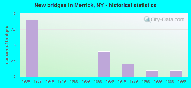
- New bridges - historical statistics
- 91930-1939
- 41960-1969
- 21970-1979
- 11980-1989
- 11990-1999
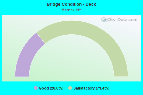
- Bridge Condition - Deck
- 28.6%Good
- 71.4%Satisfactory
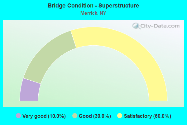
- Bridge Condition - Superstructure
- 10.0%Very good
- 30.0%Good
- 60.0%Satisfactory
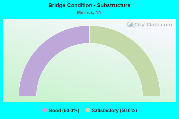
- Bridge Condition - Substructure
- 50.0%Good
- 50.0%Satisfactory
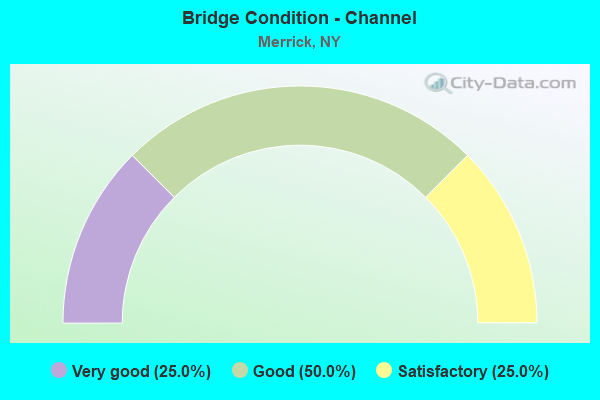
- Bridge Condition - Channel
- 25.0%Very good
- 50.0%Good
- 25.0%Satisfactory
Find on map >> Show street view
Structure Number: 1056779, Location: NEAR EAST BAY IN NASSAU (Lat: 40.609289, Lng: -73.552208), Route carried "on" structure: State highway 908C, Year Built: 1999, Status: Open, Structure Length: 20.33m (66.70ft), Average Daily Traffic: 24,193 (year 2019), Truck Traffic: 1%, Average Future Daily Traffic: 28,777 (year 2040), Design Load: HS 25 or greater, Features Intersected: SWIFT CREEK
Minimum Vertical Clearance: 30+ m (98+ ft), Kilometerpoint: 3.765, Lanes on structure: 4, Base Highway Network: Yes, Owner: State Highway Agency, Approaching Roadway Width: 19.5m (64.0ft), Skew: 20 degrees, Navigation Control: Yes ( Vertical Clearance: 6.0m (19.7ft), Horizontal Clearance: 17.6m (57.7ft)), Material/Design: Prestressed concrete continuous, Design/Construction: Box Beam or Girders - Multiple, Number Of Spans In Main Unit: 10, Length of Maximum Span: 22.8m (74.8ft), Curb-To-Curb Width: 19.5m (64.0ft), Out-to-Out Width: 23.3m (76.4ft)
Condition: Deck: Good, Superstructure: Good, Substructure: Good, Channel: Very good, Operating Rating: 89.8 metric tons, Method Used To Determine Operating Rating: Load Factor (LF), Inventory Rating: 53.5 metric tons, Method Used To Determine Inventory Rating: Load Factor (LF), Structural Evaluation: Better than present minimum criteria, Deck Geometry: Somewhat better than minimum adequacy, Waterway Adequacy: Equal to present minimum criteria, Approach Roadway Alignment: Equal to present desirable criteria, Length Of Structure Improvement: 20.33m (66.70ft), Designated Inspection Frequency: Every 24 months, Underwater Inspection Frequency: Every 60 months, Inspection Date: October 2021, Underwater Inspection Date: April 2017, Bridge Improvement Cost: $12,438,000, Roadway Improvement Cost: $7,284,000, Total Project Cost: $19,722,000 ( Estimate for 2021), Deck Structure Type: Concrete Cast-file-Place, Wearing Surface/Protective System: Wearing Surface: Monolithic Concrete, Deck Protection: Epoxy Coated Reinforcing
Find on map >> Show street view
Structure Number: 1059129, Location: NEAR EAST BAY IN NASSAU (Lat: 40.600914, Lng: -73.543542), Route carried "on" structure: State highway 908E, Year Built: 1934, Year Reconstructed: 1993, Status: Open, Structure Length: 45.14m (148.10ft), Average Daily Traffic: 15,968 (year 2019), Truck Traffic: 1%, Average Future Daily Traffic: 18,993 (year 2040), Design Load: HS 20, Features Intersected: SLOOP CHANNEL
Minimum Vertical Clearance: 30+ m (98+ ft), Kilometerpoint: 0.048, Lanes on structure: 6, Base Highway Network: Yes, Owner: State Highway Agency, Approaching Roadway Width: 21.6m (70.9ft), Skew: 20 degrees, Navigation Control: Yes ( Vertical Clearance: 6.4m (21.0ft), Horizontal Clearance: 22.8m (74.8ft)), Material/Design: Steel, Design/Construction: Movable - Bascule, Number Of Spans In Main Unit: 1, Number Of Approach Spans: 43, Length of Maximum Span: 28.3m (92.8ft), Curb-To-Curb Width: 21.6m (70.9ft), Out-to-Out Width: 23.9m (78.4ft)
Condition: Deck: Satisfactory, Superstructure: Satisfactory, Substructure: Satisfactory, Channel: Satisfactory, Operating Rating: 39.0 metric tons, Method Used To Determine Operating Rating: Allowable Stress (AS), Inventory Rating: 28.1 metric tons, Method Used To Determine Inventory Rating: Allowable Stress (AS), Structural Evaluation: Equal to present minimum criteria, Deck Geometry: High priority of replacement, Waterway Adequacy: Equal to present minimum criteria, Approach Roadway Alignment: Equal to present desirable criteria, Length Of Structure Improvement: 45.14m (148.10ft), Designated Inspection Frequency: Every 24 months, Critical Feature Inspection Frequency: Every 24 months, Underwater Inspection Frequency: Every 60 months, Inspection Date: March 2020, Critical Feature Inspection Date: March 2020, Underwater Inspection Date: Febuary 2018, Bridge Improvement Cost: $99,456,000, Roadway Improvement Cost: $58,241,000, Total Project Cost: $157,697,000 ( Estimate for 2021), Deck Structure Type: Concrete Cast-file-Place, Wearing Surface/Protective System: Wearing Surface: Monolithic Concrete, Deck Protection: Epoxy Coated Reinforcing
Find on map >> Show street view
Structure Number: 1059139, Location: NEAR EAST BAY IN NASSAU (Lat: 40.610667, Lng: -73.548775), Route carried "on" structure: State highway 908C, Year Built: 1935, Status: Open, Structure Length: 2.59m (8.50ft), Truck Traffic: 2%, Design Load: H 20, Features Intersected: 908E908E03011010, RTE 90
Minimum Vertical Clearance: 30+ m (98+ ft), Kilometerpoint: 0.209, Lanes on structure: 2, Lanes under structure: 6, Owner: State Highway Agency, Approaching Roadway Width: 20.7m (67.9ft), Skew: 20 degrees, Material/Design: Concrete, Design/Construction: Arch - Deck, Number Of Spans In Main Unit: 1, Length of Maximum Span: 24.0m (78.7ft), Curb-To-Curb Width: 20.8m (68.2ft), Out-to-Out Width: 25.5m (83.7ft)
Condition: Superstructure: Satisfactory, Substructure: Satisfactory, Operating Rating: 63.8 metric tons, Method Used To Determine Operating Rating: Field evaluation and documented engineering judgment, Inventory Rating: 24.3 metric tons, Method Used To Determine Inventory Rating: Field evaluation and documented engineering judgment, Structural Evaluation: Equal to present minimum criteria, Deck Geometry: Superior to present desirable criteria, Underclear: High priority of corrective action, Approach Roadway Alignment: Somewhat better than minimum adequacy, Length Of Structure Improvement: 2.59m (8.50ft), Designated Inspection Frequency: Every 24 months, Inspection Date: May 2020, Bridge Improvement Cost: $4,451,000, Roadway Improvement Cost: $2,606,000, Total Project Cost: $7,057,000 ( Estimate for 2021), Wearing Surface/Protective System: Wearing Surface: Bituminous, Membrane: Preformed Fabric
Find on map >> Show street view
Structure Number: 1059149, Location: NEAR EAST BAY IN NASSAU (Lat: 40.615175, Lng: -73.553769), Route carried "on" structure: State highway 908E, Year Built: 1987, Year Reconstructed: 1988, Status: Open, Structure Length: 15.64m (51.31ft), Average Daily Traffic: 30,639 (year 2019), Truck Traffic: 1%, Average Future Daily Traffic: 36,445 (year 2040), Design Load: HS 20, Features Intersected: FUNDY CHANNEL
Minimum Vertical Clearance: 30+ m (98+ ft), Kilometerpoint: 2.301, Lanes on structure: 6, Base Highway Network: Yes, Owner: State Highway Agency, Approaching Roadway Width: 23.2m (76.1ft), Skew: 20 degrees, Navigation Control: Yes ( Vertical Clearance: 4.2m (13.8ft), Horizontal Clearance: 8.8m (28.9ft)), Material/Design: Prestressed concrete continuous, Design/Construction: Box Beam or Girders - Multiple, Number Of Spans In Main Unit: 16, Length of Maximum Span: 9.7m (31.8ft), Curb-To-Curb Width: 23.2m (76.1ft), Out-to-Out Width: 23.9m (78.4ft)
Condition: Deck: Satisfactory, Superstructure: Satisfactory, Substructure: Satisfactory, Channel: Good, Operating Rating: 72.6 metric tons, Method Used To Determine Operating Rating: Load Factor (LF), Inventory Rating: 42.6 metric tons, Method Used To Determine Inventory Rating: Load Factor (LF), Structural Evaluation: Equal to present minimum criteria, Deck Geometry: Meets minimum limits, Waterway Adequacy: Equal to present minimum criteria, Approach Roadway Alignment: Equal to present desirable criteria, Length Of Structure Improvement: 15.63m (51.28ft), Designated Inspection Frequency: Every 24 months, Underwater Inspection Frequency: Every 60 months, Inspection Date: Febuary 2020, Underwater Inspection Date: May 2017, Bridge Improvement Cost: $10,422,000, Roadway Improvement Cost: $6,103,000, Total Project Cost: $16,526,000 ( Estimate for 2021), Deck Structure Type: Concrete Cast-file-Place, Wearing Surface/Protective System: Wearing Surface: Monolithic Concrete
Find on map >> Show street view
Structure Number: 1059159, Location: AT FREEPORT-S OF SSP (Lat: 40.629933, Lng: -73.562603), Route carried "on" structure: State highway 908E, Year Built: 1934, Year Reconstructed: 1988, Status: Open, Structure Length: 4.45m (14.60ft), Average Daily Traffic: 30,639 (year 2019), Truck Traffic: 1%, Average Future Daily Traffic: 36,445 (year 2040), Design Load: HS 20, Features Intersected: FALSE CHANNEL
Minimum Vertical Clearance: 30+ m (98+ ft), Kilometerpoint: 4.199, Lanes on structure: 6, Base Highway Network: Yes, Owner: State Highway Agency, Approaching Roadway Width: 22.6m (74.1ft), Skew: 20 degrees, Navigation Control: Yes ( Vertical Clearance: 3.6m (11.8ft), Horizontal Clearance: 8.5m (27.9ft)), Material/Design: Prestressed concrete continuous, Design/Construction: Box Beam or Girders - Multiple, Number Of Spans In Main Unit: 4, Number Of Approach Spans: 2, Length of Maximum Span: 9.8m (32.2ft), Curb-To-Curb Width: 22.4m (73.5ft), Out-to-Out Width: 23.9m (78.4ft)
Condition: Deck: Satisfactory, Superstructure: Satisfactory, Substructure: Satisfactory, Operating Rating: 61.7 metric tons, Method Used To Determine Operating Rating: Load Factor (LF), Inventory Rating: 37.2 metric tons, Method Used To Determine Inventory Rating: Load Factor (LF), Structural Evaluation: Equal to present minimum criteria, Deck Geometry: High priority of replacement, Waterway Adequacy: High priority of corrective action, Approach Roadway Alignment: Equal to present desirable criteria, Length Of Structure Improvement: 4.45m (14.60ft), Designated Inspection Frequency: Every 24 months, Underwater Inspection Frequency: Every 60 months, Inspection Date: October 2020, Underwater Inspection Date: August 2017, Bridge Improvement Cost: $2,712,000, Roadway Improvement Cost: $1,588,000, Total Project Cost: $4,301,000 ( Estimate for 2021), Deck Structure Type: Concrete Cast-file-Place, Wearing Surface/Protective System: Wearing Surface: Integral Concrete, Deck Protection: Epoxy Coated Reinforcing
Find on map >> Show street view
Structure Number: 1059199, Location: AT FREEPORT-S OF SSP (Lat: 40.662628, Lng: -73.568339), Route carried "on" structure: State highway 908E, Year Built: 1935, Status: Open, Structure Length: 0.76m (2.49ft), Average Daily Traffic: 71,723 (year 2019), Truck Traffic: 1%, Average Future Daily Traffic: 85,314 (year 2040), Design Load: H 20, Features Intersected: EAST MEADOW POND
Minimum Vertical Clearance: 30+ m (98+ ft), Kilometerpoint: 7.916, Lanes on structure: 6, Base Highway Network: Yes, Owner: State Highway Agency, Approaching Roadway Width: 22.6m (74.1ft), Skew: 20 degrees, Material/Design: Concrete, Design/Construction: Frame, Number Of Spans In Main Unit: 1, Length of Maximum Span: 7.3m (24.0ft), Curb or Sidewalk Widths: Left: 2.0m (6.6ft), Right: 2.0m (6.6ft), Curb-To-Curb Width: 22.6m (74.1ft), Out-to-Out Width: 36.7m (120.4ft)
Condition: Deck: Satisfactory, Superstructure: Good, Substructure: Good, Channel: Good, Operating Rating: 74.8 metric tons, Method Used To Determine Operating Rating: Field evaluation and documented engineering judgment, Inventory Rating: 32.7 metric tons, Method Used To Determine Inventory Rating: Field evaluation and documented engineering judgment, Structural Evaluation: Better than present minimum criteria, Deck Geometry: High priority of replacement, Waterway Adequacy: Equal to present minimum criteria, Approach Roadway Alignment: Equal to present desirable criteria, Length Of Structure Improvement: 0.76m (2.49ft), Designated Inspection Frequency: Every 24 months, Inspection Date: September 2021, Bridge Improvement Cost: $2,837,000, Roadway Improvement Cost: $1,661,000, Total Project Cost: $4,498,000 ( Estimate for 2021)
Find on map >> Show street view
Structure Number: 10592, Location: AT FREEPORT-S OF SSP (Lat: 40.665200, Lng: -73.568247), Route carried "on" structure: County highway , Year Built: 1963, Status: Open, Structure Length: 2.13m (6.99ft), Average Daily Traffic: 8,975 (year 2019), Truck Traffic: 4%, Average Future Daily Traffic: 10,902 (year 2040), Design Load: HS 20, Features Intersected: RTE 908E, Facility Carried by Structure: BABYLON TURNPIKE
Minimum Vertical Clearance: 30+ m (98+ ft), Kilometerpoint: 2.397, Lanes on structure: 4, Lanes under structure: 4, Owner: State Highway Agency, Approaching Roadway Width: 14.6m (47.9ft), Material/Design: Concrete, Design/Construction: Arch - Deck, Number Of Spans In Main Unit: 1, Length of Maximum Span: 19.5m (64.0ft), Curb or Sidewalk Widths: Left: 1.7m (5.6ft), Right: 1.7m (5.6ft), Curb-To-Curb Width: 14.6m (47.9ft), Out-to-Out Width: 19.2m (63.0ft)
Condition: Superstructure: Good, Substructure: Good, Operating Rating: 86.5 metric tons, Method Used To Determine Operating Rating: Field evaluation and documented engineering judgment, Inventory Rating: 32.7 metric tons, Method Used To Determine Inventory Rating: Field evaluation and documented engineering judgment, Structural Evaluation: Better than present minimum criteria, Deck Geometry: High priority of replacement, Underclear: High priority of corrective action, Approach Roadway Alignment: Equal to present desirable criteria, Length Of Structure Improvement: 2.13m (6.99ft), Designated Inspection Frequency: Every 24 months, Inspection Date: January 2021, Bridge Improvement Cost: $3,075,000, Roadway Improvement Cost: $1,801,000, Total Project Cost: $4,876,000 ( Estimate for 2021), Wearing Surface/Protective System: Wearing Surface: Bituminous
Find on map >> Show street view
Structure Number: 105921, Location: AT FREEPORT-S OF SSP (Lat: 40.680017, Lng: -73.571925), Route carried "on" structure: Other road , Year Built: 1963, Status: Open, Structure Length: 2.26m (7.41ft), Average Daily Traffic: 5,892 (year 2019), Truck Traffic: 3%, Average Future Daily Traffic: 7,290 (year 2040), Design Load: HS 20, Features Intersected: RTE 908E, Facility Carried by Structure: WASHINGTON AVENUE
Minimum Vertical Clearance: 30+ m (98+ ft), Kilometerpoint: 1.480, Lanes on structure: 4, Lanes under structure: 3, Owner: State Highway Agency, Approaching Roadway Width: 12.2m (40.0ft), Material/Design: Concrete, Design/Construction: Frame, Number Of Spans In Main Unit: 1, Length of Maximum Span: 19.8m (65.0ft), Curb or Sidewalk Widths: Left: 1.4m (4.6ft), Right: 1.7m (5.6ft), Curb-To-Curb Width: 12.2m (40.0ft), Out-to-Out Width: 16.2m (53.1ft)
Condition: Deck: Good, Superstructure: Very good, Substructure: Good, Operating Rating: 86.7 metric tons, Method Used To Determine Operating Rating: Field evaluation and documented engineering judgment, Inventory Rating: 32.7 metric tons, Method Used To Determine Inventory Rating: Field evaluation and documented engineering judgment, Structural Evaluation: Better than present minimum criteria, Deck Geometry: High priority of replacement, Underclear: High priority of corrective action, Approach Roadway Alignment: Equal to present desirable criteria, Length Of Structure Improvement: 2.25m (7.38ft), Designated Inspection Frequency: Every 24 months, Inspection Date: January 2021, Bridge Improvement Cost: $2,082,000, Roadway Improvement Cost: $1,219,000, Total Project Cost: $3,301,000 ( Estimate for 2021), Wearing Surface/Protective System: Wearing Surface: Bituminous, Membrane: Preformed Fabric
Find on map >> Show street view
Structure Number: 152036, Location: AT FREEPORT-S OF SSP (Lat: 40.665225, Lng: -73.568561), Route carried "on" structure: County highway , Year Built: 1935, Status: Open, Structure Length: 1.98m (6.50ft), Average Daily Traffic: 8,975 (year 2019), Truck Traffic: 4%, Average Future Daily Traffic: 10,902 (year 2040), Design Load: H 20, Features Intersected: RTE 908E, Facility Carried by Structure: BABYLON TURNPIKE
Minimum Vertical Clearance: 30+ m (98+ ft), Kilometerpoint: 2.349, Lanes on structure: 4, Lanes under structure: 4, Owner: State Highway Agency, Approaching Roadway Width: 14.6m (47.9ft), Material/Design: Concrete, Design/Construction: Arch - Deck, Number Of Spans In Main Unit: 1, Length of Maximum Span: 18.2m (59.7ft), Curb or Sidewalk Widths: Left: 1.7m (5.6ft), Right: 1.7m (5.6ft), Curb-To-Curb Width: 14.6m (47.9ft), Out-to-Out Width: 19.2m (63.0ft)
Condition: Superstructure: Satisfactory, Substructure: Good, Operating Rating: 56.7 metric tons, Method Used To Determine Operating Rating: Field evaluation and documented engineering judgment, Inventory Rating: 22.6 metric tons, Method Used To Determine Inventory Rating: Field evaluation and documented engineering judgment, Structural Evaluation: Somewhat better than minimum adequacy, Deck Geometry: High priority of replacement, Underclear: High priority of corrective action, Approach Roadway Alignment: Equal to present desirable criteria, Length Of Structure Improvement: 1.98m (6.50ft), Designated Inspection Frequency: Every 24 months, Inspection Date: January 2021, Bridge Improvement Cost: $2,880,000, Roadway Improvement Cost: $1,686,000, Total Project Cost: $4,566,000 ( Estimate for 2021), Wearing Surface/Protective System: Wearing Surface: Bituminous
Find on map >> Show street view
Structure Number: 152037, Location: AT FREEPORT-S OF SSP (Lat: 40.679975, Lng: -73.572250), Route carried "on" structure: Other road , Year Built: 1935, Status: Open, Structure Length: 2.26m (7.41ft), Average Daily Traffic: 5,892 (year 2019), Truck Traffic: 3%, Average Future Daily Traffic: 7,290 (year 2040), Design Load: H 20, Features Intersected: RTE 908E, Facility Carried by Structure: WASHINGTON AVENUE
Minimum Vertical Clearance: 30+ m (98+ ft), Kilometerpoint: 1.448, Lanes on structure: 4, Lanes under structure: 3, Owner: State Highway Agency, Approaching Roadway Width: 12.2m (40.0ft), Material/Design: Concrete, Design/Construction: Frame, Number Of Spans In Main Unit: 1, Length of Maximum Span: 19.8m (65.0ft), Curb or Sidewalk Widths: Left: 1.4m (4.6ft), Right: 1.4m (4.6ft), Curb-To-Curb Width: 12.2m (40.0ft), Out-to-Out Width: 16.2m (53.1ft)
Condition: Deck: Satisfactory, Superstructure: Satisfactory, Substructure: Satisfactory, Operating Rating: 58.3 metric tons, Method Used To Determine Operating Rating: Field evaluation and documented engineering judgment, Inventory Rating: 23.0 metric tons, Method Used To Determine Inventory Rating: Field evaluation and documented engineering judgment, Structural Evaluation: Somewhat better than minimum adequacy, Deck Geometry: High priority of replacement, Underclear: High priority of corrective action, Approach Roadway Alignment: Equal to present desirable criteria, Length Of Structure Improvement: 2.25m (7.38ft), Designated Inspection Frequency: Every 24 months, Inspection Date: January 2021, Bridge Improvement Cost: $2,082,000, Roadway Improvement Cost: $1,219,000, Total Project Cost: $3,301,000 ( Estimate for 2021), Wearing Surface/Protective System: Wearing Surface: Bituminous, Membrane: Preformed Fabric
Find on map >> Show street view
Structure Number: 1059139, Location: NEAR EAST BAY IN NASSAU (Lat: 40.610667, Lng: -73.548775), Route carried "under" structure: State highway 908E, Year Built: 1935, Structure Length: 0. m, Average Daily Traffic: 21,132 (year 2002), Features Intersected: 908E908E03011010, RTE 90, Facility Carried by Structure: RTE 908C
Minimum Vertical Clearance: 4.80m (15.75ft), Kilometerpoint: 1.577, Lanes on structure: 2, Lanes under structure: 3, Material/Design: Concrete, Design/Construction: Arch - Deck, Length of Maximum Span: 24.0m (78.7ft)
Find on map >> Show street view
Structure Number: 10592, Location: AT FREEPORT-S OF SSP (Lat: 40.665200, Lng: -73.568247), Route carried "under" structure: State highway 908E, Year Built: 1963, Structure Length: 0. m, Average Daily Traffic: 91,472 (year 2002), Features Intersected: RTE 908E, Facility Carried by Structure: BABYLON TURNPIKE
Minimum Vertical Clearance: 4.42m (14.50ft), Kilometerpoint: 8.093, Lanes on structure: 4, Lanes under structure: 4, Material/Design: Concrete, Design/Construction: Arch - Deck, Length of Maximum Span: 19.5m (64.0ft)
Find on map >> Show street view
Structure Number: 105921, Location: AT FREEPORT-S OF SSP (Lat: 40.680017, Lng: -73.571925), Route carried "under" structure: State highway 908E, Year Built: 1963, Structure Length: 0. m, Average Daily Traffic: 91,377 (year 2002), Features Intersected: RTE 908E, Facility Carried by Structure: WASHINGTON AVENUE
Minimum Vertical Clearance: 4.34m (14.24ft), Kilometerpoint: 9.751, Lanes on structure: 4, Lanes under structure: 3, Material/Design: Concrete, Design/Construction: Frame, Length of Maximum Span: 19.8m (65.0ft)
Find on map >> Show street view
Structure Number: 152036, Location: AT FREEPORT-S OF SSP (Lat: 40.665225, Lng: -73.568561), Route carried "under" structure: State highway 908E, Year Built: 1935, Structure Length: 0. m, Average Daily Traffic: 91,472 (year 2002), Features Intersected: RTE 908E, Facility Carried by Structure: BABYLON TURNPIKE
Minimum Vertical Clearance: 4.50m (14.76ft), Kilometerpoint: 8.093, Lanes on structure: 4, Lanes under structure: 4, Material/Design: Concrete, Design/Construction: Arch - Deck, Length of Maximum Span: 18.2m (59.7ft)
Find on map >> Show street view
Structure Number: 152037, Location: AT FREEPORT-S OF SSP (Lat: 40.679975, Lng: -73.572250), Route carried "under" structure: State highway 908E, Year Built: 1935, Structure Length: 0. m, Average Daily Traffic: 91,377 (year 2002), Features Intersected: RTE 908E, Facility Carried by Structure: WASHINGTON AVENUE
Minimum Vertical Clearance: 4.17m (13.68ft), Kilometerpoint: 9.751, Lanes on structure: 4, Lanes under structure: 3, Material/Design: Concrete, Design/Construction: Frame, Length of Maximum Span: 19.8m (65.0ft)
Find on map >> Show street view
Structure Number: 770038, Location: 0.6 MI WEST OF MERRICK (Lat: 40.661328, Lng: -73.561536), Route carried "under" structure: County highway , Year Built: 1974, Structure Length: 0. m, Average Daily Traffic: 15,600 (year 1976), Features Intersected: BABYLON TURNPIKE, Facility Carried by Structure: LIRR MERRICK
Minimum Vertical Clearance: 3.93m (12.89ft), Kilometerpoint: 0.000, Lanes under structure: 4, Material/Design: Steel, Design/Construction: Girder and Floorbeam System, Length of Maximum Span: 28.3m (92.8ft)
Find on map >> Show street view
Structure Number: 7700392, Location: AT MERRICK (Lat: 40.664072, Lng: -73.549636), Route carried "under" structure: County highway , Year Built: 1974, Structure Length: 0. m, Average Daily Traffic: 7,000 (year 1976), Features Intersected: MERRICK AVE, HEWLETT AVE, Facility Carried by Structure: LIRR MERRICK V EB
Minimum Vertical Clearance: 4.62m (15.16ft), Kilometerpoint: 0.000, Lanes under structure: 8, Material/Design: Prestressed concrete, Design/Construction: Stringer/Multi-beam, Length of Maximum Span: 25.6m (84.0ft)