Bridge Statistics for Merrifield, Virginia (VA)
Condition, Traffic, Stress, Structural Evaluation, Project Costs
- National Bridge Inventory (NBI) Statistics
- 54Number of bridges
- 427ft / 130mTotal length
- $1,453,000Total costs
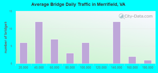
- 3,386,848Total average daily traffic
- 116,155Total average daily truck traffic
- National Bridge Inventory (NBI) Registered Bridges for Merrifield
- No street view available for this location
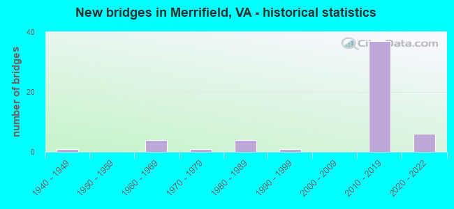
- New bridges - historical statistics
- 11940-1949
- 41960-1969
- 11970-1979
- 41980-1989
- 11990-1999
- 372010-2019
- 62020-2022
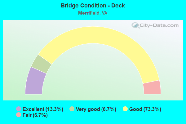
- Bridge Condition - Deck
- 13.3%Excellent
- 6.7%Very good
- 73.3%Good
- 6.7%Fair
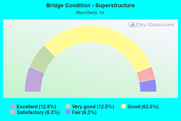
- Bridge Condition - Superstructure
- 12.5%Excellent
- 12.5%Very good
- 62.5%Good
- 6.3%Satisfactory
- 6.3%Fair
- Bridge Condition - Substructure
- 12.5%Excellent
- 6.3%Very good
- 62.5%Good
- 6.3%Satisfactory
- 12.5%Fair
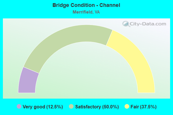
- Bridge Condition - Channel
- 12.5%Very good
- 50.0%Satisfactory
- 37.5%Fair
Find on map >> Show street view
Structure Number: 1929, Location: 0.03 RT 629 0.80 RT 691 (Lat: 38.196281, Lng: -79.406408), Route carried "on" structure: County highway 600, Year Built: 1989, Status: Open, Structure Length: 1.40m (4.59ft), Average Daily Traffic: 342 (year 2013), Average Future Daily Traffic: 388 (year 2040), Design Load: HS 20+Mod, Features Intersected: HAMILTON DRAFT, Facility Carried by Structure: MABLE VALLEY RD
Minimum Vertical Clearance: 30+ m (98+ ft), Kilometerpoint: 15.929, Lanes on structure: 2, Owner: State Highway Agency, Approaching Roadway Width: 6.1m (20.0ft), Material/Design: Concrete, Design/Construction: Slab, Number Of Spans In Main Unit: 2, Length of Maximum Span: 6.3m (20.7ft), Curb-To-Curb Width: 9.1m (29.9ft), Out-to-Out Width: 10.2m (33.5ft)
Condition: Deck: Good, Superstructure: Good, Substructure: Fair, Channel: Fair, Operating Rating: 89.8 metric tons, Method Used To Determine Operating Rating: Load and Resistance Factor (LRFR), Inventory Rating: 77.1 metric tons, Method Used To Determine Inventory Rating: Load and Resistance Factor (LRFR), Structural Evaluation: Somewhat better than minimum adequacy, Deck Geometry: Equal to present minimum criteria, Waterway Adequacy: Equal to present minimum criteria, Approach Roadway Alignment: Equal to present desirable criteria, Designated Inspection Frequency: Every 24 months, Inspection Date: August 2021, Deck Structure Type: Concrete Cast-file-Place, Wearing Surface/Protective System: Deck Protection: Epoxy Coated Reinforcing
Find on map >> Show street view
Structure Number: 6279, Location: 00.06FR700/00.18TO1076 (Lat: 38.872514, Lng: -77.254278), Route carried "on" structure: US 29, Year Built: 1987, Status: Open, Structure Length: 1.55m (5.09ft), Average Daily Traffic: 31,347 (year 2020), Truck Traffic: 4%, Average Future Daily Traffic: 43,886 (year 2040), Design Load: HS 20, Features Intersected: BEAR BRANCH, Facility Carried by Structure: LEE HIGHWAY
Minimum Vertical Clearance: 30+ m (98+ ft), Kilometerpoint: 382.202, Lanes on structure: 4, Base Highway Network: Yes, Owner: State Highway Agency, Approaching Roadway Width: 22.9m (75.1ft), Material/Design: Concrete, Design/Construction: Culvert, Number Of Spans In Main Unit: 4, Length of Maximum Span: 3.7m (12.1ft)
Condition: Channel: Fair, Culverts: Satisfactory, Operating Rating: 84.4 metric tons, Method Used To Determine Operating Rating: Load Factor (LF), Inventory Rating: 50.8 metric tons, Method Used To Determine Inventory Rating: Load Factor (LF), Structural Evaluation: Equal to present minimum criteria, Waterway Adequacy: Equal to present minimum criteria, Approach Roadway Alignment: Equal to present desirable criteria, Length Of Structure Improvement: 16.09m (52.79ft), Designated Inspection Frequency: Every 24 months, Inspection Date: May 2021, Bridge Improvement Cost: $55,000, Roadway Improvement Cost: $99,000, Total Project Cost: $175,000
Find on map >> Show street view
Structure Number: 628, Location: 00.04FR3741/00.37TO699 (Lat: 38.873214, Lng: -77.242578), Route carried "on" structure: US 29, Year Built: 1940, Status: Open, Structure Length: 0.64m (2.10ft), Average Daily Traffic: 31,347 (year 2020), Truck Traffic: 4%, Average Future Daily Traffic: 43,886 (year 2040), Design Load: HS 20, Features Intersected: LONG BRANCH, Facility Carried by Structure: LEE HWY.
Minimum Vertical Clearance: 30+ m (98+ ft), Kilometerpoint: 383.216, Lanes on structure: 6, Base Highway Network: Yes, Owner: State Highway Agency, Approaching Roadway Width: 20.7m (67.9ft), Skew: 3 degrees, Material/Design: Concrete, Design/Construction: Slab, Number Of Spans In Main Unit: 1, Length of Maximum Span: 6.4m (21.0ft), Curb or Sidewalk Widths: Left: 0.0m, Right: 1.2m (3.9ft), Curb-To-Curb Width: 20.7m (67.9ft), Out-to-Out Width: 21.6m (70.9ft)
Condition: Deck: Fair, Superstructure: Fair, Substructure: Satisfactory, Channel: Satisfactory, Operating Rating: 42.6 metric tons, Method Used To Determine Operating Rating: Load and Resistance Factor (LRFR), Inventory Rating: 32.7 metric tons, Method Used To Determine Inventory Rating: Load and Resistance Factor (LRFR), Structural Evaluation: Somewhat better than minimum adequacy, Deck Geometry: High priority of replacement, Waterway Adequacy: Equal to present desirable criteria, Approach Roadway Alignment: Equal to present desirable criteria, Length Of Structure Improvement: 0.30m (0.98ft), Designated Inspection Frequency: Every 24 months, Inspection Date: June 2021, Bridge Improvement Cost: $1,000, Roadway Improvement Cost: $1,000, Total Project Cost: $3,000 ( Estimate for 2015), Deck Structure Type: Concrete Cast-file-Place, Wearing Surface/Protective System: Wearing Surface: Bituminous
Find on map >> Show street view
Structure Number: 6341, Location: 0073243 0170495 (Lat: 38.879069, Lng: -77.253422), Route carried "on" structure: Interstate 66, Year Built: 1964, Status: Open, Structure Length: 0.70m (2.30ft), Average Daily Traffic: 126,391 (year 2020), Truck Traffic: 3%, Average Future Daily Traffic: 176,947 (year 2040), Design Load: HS 20, Features Intersected: BEAR BRANCH
Minimum Vertical Clearance: 30+ m (98+ ft), Kilometerpoint: 0.145, Lanes on structure: 8, Base Highway Network: Yes, Owner: State Highway Agency, Approaching Roadway Width: 21.3m (69.9ft), Skew: 3 degrees, Material/Design: Concrete, Design/Construction: Culvert, Number Of Spans In Main Unit: 2, Length of Maximum Span: 3.0m (9.8ft)
Condition: Channel: Satisfactory, Culverts: Satisfactory, Operating Rating: 89.8 metric tons, Method Used To Determine Operating Rating: Load Factor (LF), Inventory Rating: 89.7 metric tons, Method Used To Determine Inventory Rating: Load Factor (LF), Structural Evaluation: Equal to present minimum criteria, Waterway Adequacy: Equal to present desirable criteria, Approach Roadway Alignment: Equal to present desirable criteria, Length Of Structure Improvement: 8.78m (28.81ft), Designated Inspection Frequency: Every 24 months, Inspection Date: July 2021, Bridge Improvement Cost: $51,000, Roadway Improvement Cost: $129,000, Total Project Cost: $200,000
Find on map >> Show street view
Structure Number: 6342, Location: 01.51TO243/00.92TO495 (Lat: 38.880128, Lng: -77.238553), Route carried "on" structure: Interstate 66, Year Built: 1964, Status: Open, Structure Length: 0.85m (2.79ft), Average Daily Traffic: 126,391 (year 2020), Truck Traffic: 3%, Average Future Daily Traffic: 176,947 (year 2040), Design Load: HS 20, Features Intersected: LONG BRANCH
Minimum Vertical Clearance: 30+ m (98+ ft), Kilometerpoint: 0.177, Lanes on structure: 6, Base Highway Network: Yes, Owner: State Highway Agency, Approaching Roadway Width: 18.3m (60.0ft), Skew: 3 degrees, Material/Design: Concrete, Design/Construction: Culvert, Number Of Spans In Main Unit: 3, Length of Maximum Span: 2.4m (7.9ft)
Condition: Channel: Fair, Culverts: Satisfactory, Operating Rating: 89.8 metric tons, Method Used To Determine Operating Rating: Load Factor (LF), Inventory Rating: 89.7 metric tons, Method Used To Determine Inventory Rating: Load Factor (LF), Structural Evaluation: Equal to present minimum criteria, Waterway Adequacy: Equal to present desirable criteria, Approach Roadway Alignment: Equal to present desirable criteria, Length Of Structure Improvement: 25.05m (82.19ft), Designated Inspection Frequency: Every 24 months, Inspection Date: July 2020, Bridge Improvement Cost: $55,000, Roadway Improvement Cost: $99,000, Total Project Cost: $175,000
Find on map >> Show street view
Structure Number: 6598, Location: 00.10FR495NB/00.65TO66W (Lat: 38.883992, Lng: -77.224600), Route carried "on" structure: Ramp Interstate 495, Year Built: 1963, Year Reconstructed: 2012, Status: Open, Structure Length: 13.35m (43.80ft), Average Daily Traffic: 48,000 (year 2012), Truck Traffic: 5%, Average Future Daily Traffic: 63,000 (year 2035), Design Load: HS 20, Features Intersected: ROUTE 66 & METRO
Minimum Vertical Clearance: 30+ m (98+ ft), Kilometerpoint: 0.000, Lanes on structure: 1, Lanes under structure: 4, Base Highway Network: Yes, Owner: State Highway Agency, Maintenance Responsibility: Private, Approaching Roadway Width: 8.5m (27.9ft), Skew: 5 degrees, Material/Design: Steel, Design/Construction: Stringer/Multi-beam, Number Of Spans In Main Unit: 5, Length of Maximum Span: 51.5m (169.0ft), Curb-To-Curb Width: 4.9m (16.1ft), Out-to-Out Width: 9.1m (29.9ft)
Condition: Deck: Good, Superstructure: Good, Substructure: Good, Operating Rating: 49.9 metric tons, Method Used To Determine Operating Rating: Load and Resistance Factor (LRFR), Inventory Rating: 33.6 metric tons, Method Used To Determine Inventory Rating: Load and Resistance Factor (LRFR), Structural Evaluation: Better than present minimum criteria, Deck Geometry: High priority of corrective action, Underclear: Equal to present minimum criteria, Approach Roadway Alignment: Better than present minimum criteria, Length Of Structure Improvement: 0.30m (0.98ft), Designated Inspection Frequency: Every 24 months, Critical Feature Inspection Frequency: Every 24 months, Inspection Date: October 2020, Critical Feature Inspection Date: October 2021, Bridge Improvement Cost: $1,000, Roadway Improvement Cost: $1,000, Total Project Cost: $3,000 ( Estimate for 2016), Deck Structure Type: Concrete Cast-file-Place, Wearing Surface/Protective System: Wearing Surface: Bituminous, Membrane: Other, Deck Protection: Epoxy Coated Reinforcing
Find on map >> Show street view
Structure Number: 6632, Location: 00.30FR.495SB/00.05TO50W (Lat: 38.866319, Lng: -77.223128), Route carried "on" structure: Bypass Interstate 495, Year Built: 1985, Status: Open, Structure Length: 2.62m (8.60ft), Average Daily Traffic: 9,187 (year 2020), Average Future Daily Traffic: 12,862 (year 2040), Design Load: HS 20, Features Intersected: RAMP D OF RT 50 WBL
Minimum Vertical Clearance: 30+ m (98+ ft), Kilometerpoint: 0.000, Lanes on structure: 2, Lanes under structure: 1, Base Highway Network: Yes, Owner: State Highway Agency, Approaching Roadway Width: 12.8m (42.0ft), Skew: 4 degrees, Material/Design: Steel, Design/Construction: Stringer/Multi-beam, Number Of Spans In Main Unit: 1, Length of Maximum Span: 26.2m (86.0ft), Curb or Sidewalk Widths: Left: 0.2m (0.7ft), Right: 0.2m (0.7ft), Curb-To-Curb Width: 12.3m (40.4ft), Out-to-Out Width: 13.4m (44.0ft)
Condition: Deck: Good, Superstructure: Satisfactory, Substructure: Fair, Operating Rating: 82.6 metric tons, Method Used To Determine Operating Rating: Load and Resistance Factor (LRFR), Inventory Rating: 63.7 metric tons, Method Used To Determine Inventory Rating: Load and Resistance Factor (LRFR), Structural Evaluation: Somewhat better than minimum adequacy, Deck Geometry: Better than present minimum criteria, Underclear: Equal to present minimum criteria, Approach Roadway Alignment: Better than present minimum criteria, Length Of Structure Improvement: 0.30m (0.98ft), Designated Inspection Frequency: Every 24 months, Inspection Date: July 2021, Bridge Improvement Cost: $1,000, Roadway Improvement Cost: $1,000, Total Project Cost: $3,000 ( Estimate for 2015), Deck Structure Type: Concrete Cast-file-Place, Wearing Surface/Protective System: Wearing Surface: Monolithic Concrete, Deck Protection: Epoxy Coated Reinforcing
Find on map >> Show street view
Structure Number: 6868, Location: 00.00FR6720/00.05TO1005 (Lat: 38.867881, Lng: -77.238881), Route carried "on" structure: County highway 699, Year Built: 1979, Status: Open, Structure Length: 0.91m (2.99ft), Average Daily Traffic: 13,792 (year 2020), Truck Traffic: 1%, Average Future Daily Traffic: 17,334 (year 2040), Design Load: HS 20, Features Intersected: BRANCH OF LONG BRANCH, Facility Carried by Structure: PROSPERITY AVENUE
Minimum Vertical Clearance: 30+ m (98+ ft), Kilometerpoint: 3.516, Lanes on structure: 5, Owner: State Highway Agency, Approaching Roadway Width: 16.8m (55.1ft), Skew: 4 degrees, Material/Design: Concrete, Design/Construction: Culvert, Number Of Spans In Main Unit: 3, Length of Maximum Span: 3.0m (9.8ft)
Condition: Channel: Satisfactory, Culverts: Satisfactory, Operating Rating: 89.8 metric tons, Method Used To Determine Operating Rating: Load Factor (LF), Inventory Rating: 59.0 metric tons, Method Used To Determine Inventory Rating: Load Factor (LF), Structural Evaluation: Equal to present minimum criteria, Waterway Adequacy: Equal to present desirable criteria, Approach Roadway Alignment: Better than present minimum criteria, Length Of Structure Improvement: 0.30m (0.98ft), Designated Inspection Frequency: Every 24 months, Inspection Date: June 2021, Bridge Improvement Cost: $1,000, Roadway Improvement Cost: $1,000, Total Project Cost: $3,000 ( Estimate for 2015)
Find on map >> Show street view
Structure Number: 25009, Location: 00.10FR5152/00.07TO24872 (Lat: 38.874122, Lng: -77.254144), Route carried "on" structure: County highway 700, Year Built: 1997, Status: Open, Structure Length: 0.79m (2.59ft), Average Daily Traffic: 508 (year 2019), Average Future Daily Traffic: 561 (year 2040), Design Load: HS 20, Features Intersected: BEAR BRANCH, Facility Carried by Structure: HUNTER ROAD
Minimum Vertical Clearance: 30+ m (98+ ft), Kilometerpoint: 0.225, Lanes on structure: 2, Owner: State Highway Agency, Approaching Roadway Width: 6.4m (21.0ft), Material/Design: Concrete, Design/Construction: Arch - Deck, Number Of Spans In Main Unit: 1, Length of Maximum Span: 7.3m (24.0ft), Curb-To-Curb Width: 6.4m (21.0ft), Out-to-Out Width: 7.8m (25.6ft)
Condition: Superstructure: Good, Substructure: Good, Channel: Satisfactory, Operating Rating: 48.1 metric tons, Method Used To Determine Operating Rating: Load and Resistance Factor (LRFR), Inventory Rating: 37.0 metric tons, Method Used To Determine Inventory Rating: Load and Resistance Factor (LRFR), Structural Evaluation: Better than present minimum criteria, Deck Geometry: High priority of corrective action, Waterway Adequacy: Equal to present minimum criteria, Approach Roadway Alignment: Better than present minimum criteria, Length Of Structure Improvement: 0.73m (2.40ft), Designated Inspection Frequency: Every 24 months, Inspection Date: September 2021, Bridge Improvement Cost: $75,000, Roadway Improvement Cost: $10,000, Total Project Cost: $100,000, Wearing Surface/Protective System: Wearing Surface: Bituminous
Find on map >> Show street view
Structure Number: 28662, Location: 02.45FR0243/01.94TO0007 (Lat: 38.884056, Lng: -77.220889), Route carried "on" structure: Ramp Interstate 66, Year Built: 2011, Status: Open, Structure Length: 20.70m (67.91ft), Average Daily Traffic: 20,448 (year 2020), Truck Traffic: 3%, Average Future Daily Traffic: 28,627 (year 2040), Design Load: HS 20, Features Intersected: I-495; HOT; RAMP & HOLME
Minimum Vertical Clearance: 30+ m (98+ ft), Kilometerpoint: 0.000, Lanes on structure: 2, Lanes under structure: 14, Base Highway Network: Yes, Owner: State Highway Agency, Approaching Roadway Width: 13.4m (44.0ft), Material/Design: Steel continuous, Design/Construction: Stringer/Multi-beam, Number Of Spans In Main Unit: 4, Length of Maximum Span: 61.6m (202.1ft), Curb-To-Curb Width: 13.4m (44.0ft), Out-to-Out Width: 14.4m (47.2ft)
Condition: Deck: Good, Superstructure: Very good, Substructure: Good, Channel: Very good, Operating Rating: 88.0 metric tons, Method Used To Determine Operating Rating: Load and Resistance Factor (LRFR), Inventory Rating: 68.0 metric tons, Method Used To Determine Inventory Rating: Load and Resistance Factor (LRFR), Structural Evaluation: Better than present minimum criteria, Deck Geometry: Superior to present desirable criteria, Underclear: Equal to present minimum criteria, Waterway Adequacy: Superior to present desirable criteria, Approach Roadway Alignment: Equal to present desirable criteria, Length Of Structure Improvement: 0.30m (0.98ft), Designated Inspection Frequency: Every 24 months, Inspection Date: December 2021, Total Project Cost: $1,000, Deck Structure Type: Concrete Cast-file-Place, Wearing Surface/Protective System: Wearing Surface: Monolithic Concrete, Deck Protection: Epoxy Coated Reinforcing
Find on map >> Show street view
Structure Number: 28663, Location: 02.43FR0243/01.70TO0007 (Lat: 38.884892, Lng: -77.222575), Route carried "on" structure: Interstate 66, Year Built: 2010, Status: Open, Structure Length: 6.72m (22.05ft), Average Daily Traffic: 61,606 (year 2020), Truck Traffic: 1%, Average Future Daily Traffic: 86,248 (year 2040), Design Load: HS 20, Features Intersected: I-495 SB & SBGP
Minimum Vertical Clearance: 30+ m (98+ ft), Kilometerpoint: 0.000, Lanes on structure: 4, Lanes under structure: 8, Base Highway Network: Yes, Owner: State Highway Agency, Approaching Roadway Width: 15.2m (49.9ft), Skew: 3 degrees, Material/Design: Steel continuous, Design/Construction: Stringer/Multi-beam, Number Of Spans In Main Unit: 2, Length of Maximum Span: 34.5m (113.2ft), Curb-To-Curb Width: 14.6m (47.9ft), Out-to-Out Width: 22.3m (73.2ft)
Condition: Deck: Good, Superstructure: Good, Substructure: Good, Operating Rating: 68.2 metric tons, Method Used To Determine Operating Rating: Load and Resistance Factor (LRFR), Inventory Rating: 52.6 metric tons, Method Used To Determine Inventory Rating: Load and Resistance Factor (LRFR), Structural Evaluation: Better than present minimum criteria, Deck Geometry: High priority of replacement, Underclear: Equal to present minimum criteria, Approach Roadway Alignment: Equal to present desirable criteria, Length Of Structure Improvement: 0.61m (2.00ft), Designated Inspection Frequency: Every 24 months, Inspection Date: August 2020, Bridge Improvement Cost: $100,000, Roadway Improvement Cost: $100,000, Total Project Cost: $250,000 ( Estimate for 2014), Deck Structure Type: Concrete Cast-file-Place, Wearing Surface/Protective System: Wearing Surface: Integral Concrete, Deck Protection: Epoxy Coated Reinforcing
Find on map >> Show street view
Structure Number: 28664, Location: 02.64 fr 243 / 01.50 to 7 (Lat: 38.885592, Lng: -77.220628), Route carried "on" structure: Interstate 66, Year Built: 2010, Status: Open, Structure Length: 12.89m (42.29ft), Average Daily Traffic: 20,166 (year 2020), Truck Traffic: 1%, Average Future Daily Traffic: 28,232 (year 2040), Design Load: HS 20, Features Intersected: I-495 HOT & 66 RMPS
Minimum Vertical Clearance: 30+ m (98+ ft), Kilometerpoint: 0.000, Lanes on structure: 4, Lanes under structure: 10, Base Highway Network: Yes, Owner: State Highway Agency, Approaching Roadway Width: 23.5m (77.1ft), Skew: 4 degrees, Material/Design: Steel continuous, Design/Construction: Stringer/Multi-beam, Number Of Spans In Main Unit: 4, Length of Maximum Span: 47.3m (155.2ft), Curb-To-Curb Width: 25.2m (82.7ft), Out-to-Out Width: 25.8m (84.6ft)
Condition: Deck: Good, Superstructure: Good, Substructure: Good, Operating Rating: 79.0 metric tons, Method Used To Determine Operating Rating: Load and Resistance Factor (LRFR), Inventory Rating: 61.0 metric tons, Method Used To Determine Inventory Rating: Load and Resistance Factor (LRFR), Structural Evaluation: Better than present minimum criteria, Deck Geometry: Superior to present desirable criteria, Underclear: High priority of corrective action, Approach Roadway Alignment: Equal to present desirable criteria, Length Of Structure Improvement: 3.05m (10.01ft), Designated Inspection Frequency: Every 24 months, Inspection Date: August 2020, Bridge Improvement Cost: $1,000, Roadway Improvement Cost: $1,000, Total Project Cost: $3,000 ( Estimate for 2014), Deck Structure Type: Concrete Cast-file-Place, Wearing Surface/Protective System: Wearing Surface: Monolithic Concrete, Deck Protection: Epoxy Coated Reinforcing
Find on map >> Show street view
Structure Number: 28665, Location: 02.51FR243 / 01.64TO 7 (Lat: 38.885906, Lng: -77.222333), Route carried "on" structure: Interstate 66, Year Built: 2010, Status: Open, Structure Length: 8.38m (27.49ft), Average Daily Traffic: 64,785 (year 2020), Truck Traffic: 1%, Average Future Daily Traffic: 90,699 (year 2040), Design Load: HS 20, Features Intersected: 66 RAMP & 495 HOT
Minimum Vertical Clearance: 30+ m (98+ ft), Kilometerpoint: 0.000, Lanes on structure: 4, Lanes under structure: 9, Base Highway Network: Yes, Owner: State Highway Agency, Approaching Roadway Width: 21.3m (69.9ft), Skew: 4 degrees, Material/Design: Steel continuous, Design/Construction: Stringer/Multi-beam, Number Of Spans In Main Unit: 2, Length of Maximum Span: 42.7m (140.1ft), Curb-To-Curb Width: 14.6m (47.9ft), Out-to-Out Width: 21.9m (71.9ft)
Condition: Deck: Good, Superstructure: Good, Substructure: Good, Operating Rating: 71.7 metric tons, Method Used To Determine Operating Rating: Load and Resistance Factor (LRFR), Inventory Rating: 55.3 metric tons, Method Used To Determine Inventory Rating: Load and Resistance Factor (LRFR), Structural Evaluation: Better than present minimum criteria, Deck Geometry: High priority of replacement, Underclear: Meets minimum limits, Approach Roadway Alignment: Equal to present desirable criteria, Length Of Structure Improvement: 3.05m (10.01ft), Designated Inspection Frequency: Every 24 months, Inspection Date: October 2020, Bridge Improvement Cost: $1,000, Roadway Improvement Cost: $1,000, Total Project Cost: $3,000 ( Estimate for 2014), Deck Structure Type: Concrete Cast-file-Place, Wearing Surface/Protective System: Wearing Surface: Monolithic Concrete, Deck Protection: Epoxy Coated Reinforcing
Find on map >> Show street view
Structure Number: 28666, Location: 02.67FR0243/01.48TO0007 (Lat: 38.886936, Lng: -77.220014), Route carried "on" structure: Interstate 66, Year Built: 2010, Status: Open, Structure Length: 12.82m (42.06ft), Average Daily Traffic: 64,785 (year 2020), Truck Traffic: 1%, Average Future Daily Traffic: 90,699 (year 2040), Design Load: HS 20, Features Intersected: I-495NB &HOT; I-66 RAMPS, Facility Carried by Structure: CUSTIS MEM PKWY WB
Minimum Vertical Clearance: 30.45m (99.90ft), Kilometerpoint: 0.000, Lanes on structure: 3, Lanes under structure: 12, Base Highway Network: Yes, Owner: State Highway Agency, Approaching Roadway Width: 18.3m (60.0ft), Skew: 5 degrees, Material/Design: Steel continuous, Design/Construction: Stringer/Multi-beam, Number Of Spans In Main Unit: 3, Length of Maximum Span: 55.3m (181.4ft), Curb-To-Curb Width: 11.0m (36.1ft), Out-to-Out Width: 23.6m (77.4ft)
Condition: Deck: Good, Superstructure: Good, Substructure: Good, Operating Rating: 88.0 metric tons, Method Used To Determine Operating Rating: Load and Resistance Factor (LRFR), Inventory Rating: 68.0 metric tons, Method Used To Determine Inventory Rating: Load and Resistance Factor (LRFR), Structural Evaluation: Better than present minimum criteria, Deck Geometry: High priority of replacement, Underclear: High priority of corrective action, Approach Roadway Alignment: Equal to present desirable criteria, Length Of Structure Improvement: 1.52m (4.99ft), Designated Inspection Frequency: Every 24 months, Inspection Date: October 2020, Bridge Improvement Cost: $100,000, Roadway Improvement Cost: $100,000, Total Project Cost: $250,000 ( Estimate for 2014), Deck Structure Type: Concrete Cast-file-Place, Wearing Surface/Protective System: Wearing Surface: Integral Concrete, Deck Protection: Epoxy Coated Reinforcing
Find on map >> Show street view
Structure Number: 28671, Location: 01.29FR0066/00.83TO0650 (Lat: 38.866050, Lng: -77.220456), Route carried "on" structure: Interstate 495, Year Built: 2010, Status: Open, Structure Length: 5.64m (18.50ft), Average Daily Traffic: 99,152 (year 2020), Truck Traffic: 5%, Average Future Daily Traffic: 138,813 (year 2040), Design Load: HS 20, Features Intersected: RTE.50
Minimum Vertical Clearance: 30.45m (99.90ft), Kilometerpoint: 0.000, Lanes on structure: 6, Lanes under structure: 10, Base Highway Network: Yes, Owner: State Highway Agency, Approaching Roadway Width: 24.4m (80.1ft), Material/Design: Prestressed concrete, Design/Construction: Stringer/Multi-beam, Number Of Spans In Main Unit: 2, Length of Maximum Span: 28.2m (92.5ft), Curb-To-Curb Width: 21.9m (71.9ft), Out-to-Out Width: 32.4m (106.3ft)
Condition: Deck: Very good, Superstructure: Good, Substructure: Very good, Operating Rating: 77.4 metric tons, Method Used To Determine Operating Rating: Load and Resistance Factor (LRFR), Inventory Rating: 59.3 metric tons, Method Used To Determine Inventory Rating: Load and Resistance Factor (LRFR), Structural Evaluation: Better than present minimum criteria, Deck Geometry: High priority of replacement, Underclear: High priority of corrective action, Approach Roadway Alignment: Equal to present desirable criteria, Length Of Structure Improvement: 1.52m (4.99ft), Designated Inspection Frequency: Every 24 months, Inspection Date: September 2020, Bridge Improvement Cost: $100,000, Roadway Improvement Cost: $100,000, Total Project Cost: $250,000 ( Estimate for 2014), Deck Structure Type: Concrete Cast-file-Place, Wearing Surface/Protective System: Wearing Surface: Integral Concrete, Deck Protection: Epoxy Coated Reinforcing
Find on map >> Show street view
Structure Number: 28673, Location: 00.09FR0703/00.36TO0650 (Lat: 38.875722, Lng: -77.220989), Route carried "on" structure: US 29, Year Built: 2010, Status: Open, Structure Length: 9.08m (29.79ft), Average Daily Traffic: 33,621 (year 2020), Truck Traffic: 4%, Average Future Daily Traffic: 36,983 (year 2040), Design Load: HS 20, Features Intersected: I-495, Facility Carried by Structure: Lee Highway
Minimum Vertical Clearance: 5.49m (18.01ft), Kilometerpoint: 0.000, Lanes on structure: 5, Lanes under structure: 14, Base Highway Network: Yes, Owner: State Highway Agency, Approaching Roadway Width: 29.9m (98.1ft), Skew: 20 degrees, Material/Design: Steel continuous, Design/Construction: Stringer/Multi-beam, Number Of Spans In Main Unit: 2, Length of Maximum Span: 45.2m (148.3ft), Curb or Sidewalk Widths: Left: 2.0m (6.6ft), Right: 1.7m (5.6ft), Curb-To-Curb Width: 18.3m (60.0ft), Out-to-Out Width: 34.0m (111.5ft)
Condition: Deck: Good, Superstructure: Good, Substructure: Good, Inventory Rating: 90.4 metric tons, Method Used To Determine Inventory Rating: Load and Resistance Factor (LRFR), Structural Evaluation: Better than present minimum criteria, Deck Geometry: High priority of replacement, Underclear: Equal to present minimum criteria, Approach Roadway Alignment: Equal to present desirable criteria, Length Of Structure Improvement: 0.30m (0.98ft), Designated Inspection Frequency: Every 24 months, Inspection Date: August 2020, Bridge Improvement Cost: $10,000, Roadway Improvement Cost: $10,000, Total Project Cost: $25,000 ( Estimate for 2014), Deck Structure Type: Concrete Cast-file-Place, Wearing Surface/Protective System: Wearing Surface: Integral Concrete, Deck Protection: Epoxy Coated Reinforcing
Find on map >> Show street view
Structure Number: 28675, Location: 00.30FR495NB/00.50TO66W (Lat: 38.882689, Lng: -77.222311), Route carried "on" structure: Ramp Interstate 495, Year Built: 2012, Status: Open, Structure Length: 8.50m (27.89ft), Average Daily Traffic: 83,981 (year 2020), Truck Traffic: 5%, Average Future Daily Traffic: 117,573 (year 2040), Design Load: HS 20, Features Intersected: I-495SB & HOT, Facility Carried by Structure: 66 RAMP SWH
Minimum Vertical Clearance: 30.18m (99.02ft), Kilometerpoint: 0.000, Lanes on structure: 1, Lanes under structure: 7, Base Highway Network: Yes, Toll: On toll road, Owner: State Highway Agency, Maintenance Responsibility: Private, Approaching Roadway Width: 9.1m (29.9ft), Material/Design: Concrete, Design/Construction: Slab, Number Of Spans In Main Unit: 2, Number Of Approach Spans: 2, Length of Maximum Span: 44.2m (145.0ft), Curb or Sidewalk Widths: Left: 0.5m (1.6ft), Right: 0.5m (1.6ft), Curb-To-Curb Width: 7.3m (24.0ft), Out-to-Out Width: 10.2m (33.5ft)
Condition: Deck: Good, Superstructure: Good, Substructure: Good, Operating Rating: 63.5 metric tons, Method Used To Determine Operating Rating: Load and Resistance Factor (LRFR), Inventory Rating: 49.0 metric tons, Method Used To Determine Inventory Rating: Load and Resistance Factor (LRFR), Structural Evaluation: Better than present minimum criteria, Deck Geometry: Better than present minimum criteria, Underclear: High priority of corrective action, Approach Roadway Alignment: Equal to present desirable criteria, Length Of Structure Improvement: 0.30m (0.98ft), Designated Inspection Frequency: Every 24 months, Inspection Date: August 2020, Bridge Improvement Cost: $1,000, Roadway Improvement Cost: $1,000, Total Project Cost: $3,000 ( Estimate for 2016), Deck Structure Type: Concrete Cast-file-Place, Wearing Surface/Protective System: Wearing Surface: Monolithic Concrete, Deck Protection: Epoxy Coated Reinforcing
Find on map >> Show street view
Structure Number: 28676, Location: .27FR495SB /.09TO66WB (Lat: 38.887597, Lng: -77.219750), Route carried "on" structure: Ramp Interstate 66, Year Built: 2012, Status: Open, Structure Length: 2.32m (7.61ft), Average Daily Traffic: 92,489 (year 2020), Truck Traffic: 5%, Average Future Daily Traffic: 129,485 (year 2040), Design Load: HS 20, Features Intersected: RTE.66 RAMP
Minimum Vertical Clearance: 30.18m (99.02ft), Kilometerpoint: 0.000, Lanes on structure: 1, Lanes under structure: 1, Base Highway Network: Yes, Toll: On toll road, Owner: State Highway Agency, Maintenance Responsibility: Private, Approaching Roadway Width: 9.1m (29.9ft), Skew: 3 degrees, Material/Design: Concrete, Design/Construction: Stringer/Multi-beam, Number Of Spans In Main Unit: 1, Number Of Approach Spans: 2, Length of Maximum Span: 23.2m (76.1ft), Curb-To-Curb Width: 9.1m (29.9ft), Out-to-Out Width: 10.2m (33.5ft)
Condition: Deck: Good, Superstructure: Very good, Substructure: Good, Operating Rating: 89.8 metric tons, Method Used To Determine Operating Rating: Load and Resistance Factor (LRFR), Inventory Rating: 71.7 metric tons, Method Used To Determine Inventory Rating: Load and Resistance Factor (LRFR), Structural Evaluation: Better than present minimum criteria, Deck Geometry: Superior to present desirable criteria, Underclear: Somewhat better than minimum adequacy, Approach Roadway Alignment: Equal to present desirable criteria, Length Of Structure Improvement: 0.30m (0.98ft), Designated Inspection Frequency: Every 24 months, Inspection Date: August 2020, Bridge Improvement Cost: $1,000, Roadway Improvement Cost: $1,000, Total Project Cost: $3,000 ( Estimate for 2016), Deck Structure Type: Concrete Cast-file-Place, Wearing Surface/Protective System: Wearing Surface: Monolithic Concrete, Deck Protection: Epoxy Coated Reinforcing
Find on map >> Show street view
Structure Number: 30944, Location: 00.15FR1195/00.10TO2946 (Lat: 38.883136, Lng: -77.227719), Route carried "on" structure: County highway 650, Year Built: 2021, Status: Open, Structure Length: 10.94m (35.89ft), Average Daily Traffic: 34,275 (year 2014), Truck Traffic: 1%, Average Future Daily Traffic: 47,619 (year 2035), Design Load: HL 93, Features Intersected: CUSTIS MEMORIAL PARKWAY, Facility Carried by Structure: GALLOWS ROAD
Minimum Vertical Clearance: 30+ m (98+ ft), Kilometerpoint: 7.208, Lanes on structure: 6, Lanes under structure: 9, Owner: State Highway Agency, Approaching Roadway Width: 15.5m (50.9ft), Skew: 11 degrees, Material/Design: Concrete, Design/Construction: Stringer/Multi-beam, Number Of Spans In Main Unit: 2, Length of Maximum Span: 106.4m (349.1ft), Curb or Sidewalk Widths: Left: 3.0m (9.8ft), Right: 3.4m (11.2ft), Curb-To-Curb Width: 17.7m (58.1ft), Out-to-Out Width: 37.2m (122.0ft)
Condition: Deck: Excellent, Superstructure: Excellent, Substructure: Excellent, Operating Rating: 74.6 metric tons, Method Used To Determine Operating Rating: Load and Resistance Factor (LRFR), Inventory Rating: 57.5 metric tons, Method Used To Determine Inventory Rating: Load and Resistance Factor (LRFR), Structural Evaluation: Superior to present desirable criteria, Deck Geometry: High priority of replacement, Underclear: Superior to present desirable criteria, Approach Roadway Alignment: Equal to present desirable criteria, Length Of Structure Improvement: 0.30m (0.98ft), Designated Inspection Frequency: Every 24 months, Inspection Date: October 2021, Bridge Improvement Cost: $1,000, Roadway Improvement Cost: $1,000, Total Project Cost: $3,000 ( Estimate for 2015), Deck Structure Type: Concrete Cast-file-Place, Wearing Surface/Protective System: Wearing Surface: Monolithic Concrete, Deck Protection: Other Coated Reinforcing
Find on map >> Show street view
Structure Number: 30945, Location: 00.04fr744 00.18to2401 (Lat: 38.879272, Lng: -77.246808), Route carried "on" structure: County highway 698, Year Built: 2020, Status: Open, Structure Length: 8.87m (29.10ft), Average Daily Traffic: 9,735 (year 2020), Average Future Daily Traffic: 11,999 (year 2040), Design Load: HL 93, Features Intersected: I-66, Facility Carried by Structure: CEDAR LANE
Minimum Vertical Clearance: 30.18m (99.02ft), Kilometerpoint: 0.000, Lanes on structure: 2, Lanes under structure: 8, Owner: State Highway Agency, Approaching Roadway Width: 8.5m (27.9ft), Material/Design: Steel, Design/Construction: Stringer/Multi-beam, Number Of Spans In Main Unit: 1, Number Of Approach Spans: 2, Length of Maximum Span: 48.5m (159.1ft), Curb or Sidewalk Widths: Left: 1.8m (5.9ft), Right: 4.6m (15.1ft), Curb-To-Curb Width: 7.3m (24.0ft), Out-to-Out Width: 16.5m (54.1ft)
Condition: Deck: Excellent, Superstructure: Excellent, Substructure: Excellent, Operating Rating: 81.3 metric tons, Method Used To Determine Operating Rating: Load and Resistance Factor (LRFR), Inventory Rating: 62.7 metric tons, Method Used To Determine Inventory Rating: Load and Resistance Factor (LRFR), Structural Evaluation: Superior to present desirable criteria, Deck Geometry: High priority of replacement, Underclear: Equal to present desirable criteria, Approach Roadway Alignment: Better than present minimum criteria, Designated Inspection Frequency: Every 24 months, Inspection Date: December 2020, Deck Structure Type: Concrete Cast-file-Place, Wearing Surface/Protective System: Wearing Surface: Monolithic Concrete, Deck Protection: Other
Find on map >> Show street view
Structure Number: 6598, Location: 00.10FR495NB/00.65TO66W (Lat: 38.883992, Lng: -77.224600), Route carried "under" structure: Interstate 66, Year Built: 1963, Structure Length: 0. m, Average Daily Traffic: 93,500 (year 1994), Features Intersected: ROUTE 66 & METRO, Facility Carried by Structure: RAMP B OF 495
Minimum Vertical Clearance: 5.28m (17.32ft), Kilometerpoint: 25.229, Lanes on structure: 1, Lanes under structure: 4, Material/Design: Steel, Design/Construction: Stringer/Multi-beam, Length of Maximum Span: 51.5m (169.0ft)
Find on map >> Show street view
Structure Number: 6632, Location: 00.30FR.495SB/00.05TO50W (Lat: 38.866319, Lng: -77.223128), Route carried "under" structure: Ramp US 50, Year Built: 1985, Structure Length: 0. m, Average Daily Traffic: 10,000 (year 1992), Features Intersected: RAMP D OF RT 50 WBL, Facility Carried by Structure: RAMP H OF I495_SB
Minimum Vertical Clearance: 5.11m (16.77ft), Kilometerpoint: 0.000, Lanes on structure: 2, Lanes under structure: 1, Material/Design: Steel, Design/Construction: Stringer/Multi-beam, Length of Maximum Span: 26.2m (86.0ft)
Find on map >> Show street view
Structure Number: 28662, Location: 02.45FR0243/01.94TO0007 (Lat: 38.884056, Lng: -77.220889), Route carried "under" structure: Interstate 495, Year Built: 2011, Structure Length: 0. m, Average Daily Traffic: 120,000 (year 2011), Truck Traffic: 2%, Features Intersected: I-495; HOT; RAMP & HOLME, Facility Carried by Structure: RAMP 66 WN
Minimum Vertical Clearance: 6.86m (22.51ft), Kilometerpoint: 0.000, Lanes on structure: 2, Lanes under structure: 4, Material/Design: Steel continuous, Design/Construction: Stringer/Multi-beam, Length of Maximum Span: 61.6m (202.1ft)
Find on map >> Show street view
Structure Number: 28662, Location: 02.45FR0243/01.94TO0007 (Lat: 38.884056, Lng: -77.220889), Route carried "under" structure: Ramp Interstate 66, Year Built: 2011, Structure Length: 0. m, Average Daily Traffic: 30,000 (year 2011), Features Intersected: I-495; HOT; RAMP & HOLME
Minimum Vertical Clearance: 5.61m (18.41ft), Kilometerpoint: 0.000, Lanes on structure: 2, Lanes under structure: 1, Material/Design: Steel continuous, Design/Construction: Stringer/Multi-beam, Length of Maximum Span: 61.6m (202.1ft)
Find on map >> Show street view
Structure Number: 28662, Location: 02.45FR0243/01.94TO0007 (Lat: 38.884056, Lng: -77.220889), Route carried "under" structure: Alternate Interstate 495, Year Built: 2011, Structure Length: 0. m, Average Daily Traffic: 120,000 (year 2011), Features Intersected: I-495; HOT; RAMP & HOLME, Facility Carried by Structure: RAMP 66 WN
Minimum Vertical Clearance: 7.36m (24.15ft), Kilometerpoint: 0.000, Lanes on structure: 2, Lanes under structure: 2, Toll: On toll road, Material/Design: Steel continuous, Design/Construction: Stringer/Multi-beam, Length of Maximum Span: 61.6m (202.1ft)
Find on map >> Show street view
Structure Number: 28662, Location: 02.45FR0243/01.94TO0007 (Lat: 38.884056, Lng: -77.220889), Route carried "under" structure: Alternate Interstate 495, Year Built: 2011, Structure Length: 0. m, Average Daily Traffic: 120,000 (year 2011), Features Intersected: I-495; HOT; RAMP & HOLME, Facility Carried by Structure: RAMP 66 WN
Minimum Vertical Clearance: 10.57m (34.68ft), Kilometerpoint: 0.000, Lanes on structure: 2, Lanes under structure: 3, Toll: On toll road, Material/Design: Steel continuous, Design/Construction: Stringer/Multi-beam, Length of Maximum Span: 61.6m (202.1ft)
Find on map >> Show street view
Structure Number: 28662, Location: 02.45FR0243/01.94TO0007 (Lat: 38.884056, Lng: -77.220889), Route carried "under" structure: Interstate 495, Year Built: 2011, Structure Length: 0. m, Average Daily Traffic: 120,000 (year 2011), Truck Traffic: 2%, Features Intersected: I-495; HOT; RAMP & HOLME, Facility Carried by Structure: RAMP 66 WN
Minimum Vertical Clearance: 10.21m (33.50ft), Kilometerpoint: 0.000, Lanes on structure: 2, Lanes under structure: 4, Material/Design: Steel continuous, Design/Construction: Stringer/Multi-beam, Length of Maximum Span: 61.6m (202.1ft)
Find on map >> Show street view
Structure Number: 28663, Location: 02.43FR0243/01.70TO0007 (Lat: 38.884892, Lng: -77.222575), Route carried "under" structure: Interstate 495, Year Built: 2010, Structure Length: 0. m, Average Daily Traffic: 150,000 (year 2010), Truck Traffic: 2%, Features Intersected: I-495 SB & SBGP, Facility Carried by Structure: I-66 EB & Ramp
Minimum Vertical Clearance: 6.10m (20.01ft), Kilometerpoint: 0.000, Lanes on structure: 4, Lanes under structure: 4, Material/Design: Steel continuous, Design/Construction: Stringer/Multi-beam, Length of Maximum Span: 34.5m (113.2ft)
Find on map >> Show street view
Structure Number: 28663, Location: 02.43FR0243/01.70TO0007 (Lat: 38.884892, Lng: -77.222575), Route carried "under" structure: Interstate 495, Year Built: 2010, Structure Length: 0. m, Features Intersected: I-495 SB & SBGP, Facility Carried by Structure: I-66 EB & Ramp
Minimum Vertical Clearance: 5.97m (19.59ft), Kilometerpoint: 0.000, Lanes on structure: 4, Lanes under structure: 4, Material/Design: Steel continuous, Design/Construction: Stringer/Multi-beam, Length of Maximum Span: 34.5m (113.2ft)
Find on map >> Show street view
Structure Number: 28664, Location: 02.64 fr 243 / 01.50 to 7 (Lat: 38.885592, Lng: -77.220628), Route carried "under" structure: Ramp Interstate 495, Year Built: 2010, Structure Length: 0. m, Average Daily Traffic: 46,000 (year 2010), Truck Traffic: 5%, Features Intersected: I-495 HOT & 66 RMPS, Facility Carried by Structure: I-66 RAMP SEH
Minimum Vertical Clearance: 6.50m (21.33ft), Kilometerpoint: 0.000, Lanes on structure: 4, Lanes under structure: 2, Material/Design: Steel continuous, Design/Construction: Stringer/Multi-beam, Length of Maximum Span: 47.3m (155.2ft)
Find on map >> Show street view
Structure Number: 28664, Location: 02.64 fr 243 / 01.50 to 7 (Lat: 38.885592, Lng: -77.220628), Route carried "under" structure: Interstate , Year Built: 2010, Structure Length: 0. m, Average Daily Traffic: 56,000 (year 2010), Truck Traffic: 4%, Features Intersected: I-495 HOT & 66 RMPS, Facility Carried by Structure: I-66 RAMP SEH
Minimum Vertical Clearance: 5.23m (17.16ft), Kilometerpoint: 0.000, Lanes on structure: 4, Lanes under structure: 2, Material/Design: Steel continuous, Design/Construction: Stringer/Multi-beam, Length of Maximum Span: 47.3m (155.2ft)
Find on map >> Show street view
Structure Number: 28664, Location: 02.64 fr 243 / 01.50 to 7 (Lat: 38.885592, Lng: -77.220628), Route carried "under" structure: Ramp Interstate 66, Year Built: 2010, Structure Length: 0. m, Average Daily Traffic: 45,000 (year 2010), Truck Traffic: 6%, Features Intersected: I-495 HOT & 66 RMPS
Minimum Vertical Clearance: 5.89m (19.32ft), Kilometerpoint: 0.000, Lanes on structure: 4, Lanes under structure: 2, Material/Design: Steel continuous, Design/Construction: Stringer/Multi-beam, Length of Maximum Span: 47.3m (155.2ft)
Find on map >> Show street view
Structure Number: 28664, Location: 02.64 fr 243 / 01.50 to 7 (Lat: 38.885592, Lng: -77.220628), Route carried "under" structure: Interstate 495, Year Built: 2010, Structure Length: 0. m, Average Daily Traffic: 154,000 (year 2010), Truck Traffic: 15%, Features Intersected: I-495 HOT & 66 RMPS, Facility Carried by Structure: I-66 RAMP SEH
Minimum Vertical Clearance: 5.94m (19.49ft), Kilometerpoint: 0.000, Lanes on structure: 4, Lanes under structure: 4, Material/Design: Steel continuous, Design/Construction: Stringer/Multi-beam, Length of Maximum Span: 47.3m (155.2ft)
Find on map >> Show street view
Structure Number: 28665, Location: 02.51FR243 / 01.64TO 7 (Lat: 38.885906, Lng: -77.222333), Route carried "under" structure: Interstate 495, Year Built: 2010, Structure Length: 0. m, Average Daily Traffic: 160,000 (year 2010), Truck Traffic: 10%, Features Intersected: 66 RAMP & 495 HOT, Facility Carried by Structure: I-66 WB
Minimum Vertical Clearance: 6.38m (20.93ft), Kilometerpoint: 0.000, Lanes on structure: 4, Lanes under structure: 4, Material/Design: Steel continuous, Design/Construction: Stringer/Multi-beam, Length of Maximum Span: 42.7m (140.1ft)
Find on map >> Show street view
Structure Number: 28665, Location: 02.51FR243 / 01.64TO 7 (Lat: 38.885906, Lng: -77.222333), Route carried "under" structure: Interstate 495, Year Built: 2010, Structure Length: 0. m, Average Daily Traffic: 135,000 (year 2010), Truck Traffic: 10%, Features Intersected: 66 RAMP & 495 HOT, Facility Carried by Structure: I-66 WB
Minimum Vertical Clearance: 6.86m (22.51ft), Kilometerpoint: 0.000, Lanes on structure: 4, Lanes under structure: 4, Material/Design: Steel continuous, Design/Construction: Stringer/Multi-beam, Length of Maximum Span: 42.7m (140.1ft)
Find on map >> Show street view
Structure Number: 28666, Location: 02.67FR0243/01.48TO0007 (Lat: 38.886936, Lng: -77.220014), Route carried "under" structure: Ramp Interstate 66, Year Built: 2010, Structure Length: 0. m, Average Daily Traffic: 50,000 (year 2010), Truck Traffic: 1%, Features Intersected: I-495NB &HOT; I-66 RAMPS, Facility Carried by Structure: CUSTIS MEM PKWY WB
Minimum Vertical Clearance: 6.20m (20.34ft), Kilometerpoint: 0.000, Lanes on structure: 3, Lanes under structure: 2, Material/Design: Steel continuous, Design/Construction: Stringer/Multi-beam, Length of Maximum Span: 55.3m (181.4ft)
Find on map >> Show street view
Structure Number: 28666, Location: 02.67FR0243/01.48TO0007 (Lat: 38.886936, Lng: -77.220014), Route carried "under" structure: Ramp Interstate 66, Year Built: 2010, Structure Length: 0. m, Average Daily Traffic: 50,000 (year 2010), Truck Traffic: 1%, Features Intersected: I-495NB &HOT; I-66 RAMPS, Facility Carried by Structure: CUSTIS MEM PKWY WB
Minimum Vertical Clearance: 6.55m (21.49ft), Kilometerpoint: 0.000, Lanes on structure: 3, Lanes under structure: 2, Material/Design: Steel continuous, Design/Construction: Stringer/Multi-beam, Length of Maximum Span: 55.3m (181.4ft)
Find on map >> Show street view
Structure Number: 28666, Location: 02.67FR0243/01.48TO0007 (Lat: 38.886936, Lng: -77.220014), Route carried "under" structure: Ramp Interstate 66, Year Built: 2010, Structure Length: 0. m, Average Daily Traffic: 50,000 (year 2010), Truck Traffic: 1%, Features Intersected: I-495NB &HOT; I-66 RAMPS, Facility Carried by Structure: CUSTIS MEM PKWY WB
Minimum Vertical Clearance: 5.84m (19.16ft), Kilometerpoint: 0.000, Lanes on structure: 3, Lanes under structure: 2, Toll: On toll road, Material/Design: Steel continuous, Design/Construction: Stringer/Multi-beam, Length of Maximum Span: 55.3m (181.4ft)
Find on map >> Show street view
Structure Number: 28666, Location: 02.67FR0243/01.48TO0007 (Lat: 38.886936, Lng: -77.220014), Route carried "under" structure: US 495, Year Built: 2010, Structure Length: 0. m, Average Daily Traffic: 120,000 (year 2010), Truck Traffic: 1%, Features Intersected: I-495NB &HOT; I-66 RAMPS, Facility Carried by Structure: CUSTIS MEM PKWY WB
Minimum Vertical Clearance: 5.99m (19.65ft), Kilometerpoint: 0.000, Lanes on structure: 3, Lanes under structure: 6, Material/Design: Steel continuous, Design/Construction: Stringer/Multi-beam, Length of Maximum Span: 55.3m (181.4ft)
Find on map >> Show street view
Structure Number: 28671, Location: 01.29FR0066/00.83TO0650 (Lat: 38.866050, Lng: -77.220456), Route carried "under" structure: US 50, Year Built: 2010, Structure Length: 0. m, Average Daily Traffic: 80,000 (year 2010), Truck Traffic: 1%, Features Intersected: RTE.50, Facility Carried by Structure: I-495 SBL
Minimum Vertical Clearance: 5.39m (17.68ft), Kilometerpoint: 0.000, Lanes on structure: 6, Lanes under structure: 4, Material/Design: Prestressed concrete, Design/Construction: Stringer/Multi-beam, Length of Maximum Span: 28.2m (92.5ft)
Find on map >> Show street view
Structure Number: 28671, Location: 01.29FR0066/00.83TO0650 (Lat: 38.866050, Lng: -77.220456), Route carried "under" structure: Ramp US 50, Year Built: 2010, Structure Length: 0. m, Average Daily Traffic: 30,000 (year 2010), Truck Traffic: 1%, Features Intersected: RTE.50, Facility Carried by Structure: I-495 SBL
Minimum Vertical Clearance: 5.72m (18.77ft), Kilometerpoint: 0.000, Lanes on structure: 6, Lanes under structure: 1, Material/Design: Prestressed concrete, Design/Construction: Stringer/Multi-beam, Length of Maximum Span: 28.2m (92.5ft)
Find on map >> Show street view
Structure Number: 28671, Location: 01.29FR0066/00.83TO0650 (Lat: 38.866050, Lng: -77.220456), Route carried "under" structure: US 50, Year Built: 2010, Structure Length: 0. m, Average Daily Traffic: 80,000 (year 2010), Truck Traffic: 1%, Features Intersected: RTE.50, Facility Carried by Structure: I-495 SBL
Minimum Vertical Clearance: 5.59m (18.34ft), Kilometerpoint: 0.000, Lanes on structure: 6, Lanes under structure: 4, Material/Design: Prestressed concrete, Design/Construction: Stringer/Multi-beam, Length of Maximum Span: 28.2m (92.5ft)
Find on map >> Show street view
Structure Number: 28671, Location: 01.29FR0066/00.83TO0650 (Lat: 38.866050, Lng: -77.220456), Route carried "under" structure: Ramp US 50, Year Built: 2010, Structure Length: 0. m, Average Daily Traffic: 30,000 (year 2010), Truck Traffic: 1%, Features Intersected: RTE.50, Facility Carried by Structure: I-495 SBL
Minimum Vertical Clearance: 5.49m (18.01ft), Kilometerpoint: 0.000, Lanes on structure: 6, Lanes under structure: 1, Material/Design: Prestressed concrete, Design/Construction: Stringer/Multi-beam, Length of Maximum Span: 28.2m (92.5ft)
Find on map >> Show street view
Structure Number: 28673, Location: 00.09FR0703/00.36TO0650 (Lat: 38.875722, Lng: -77.220989), Route carried "under" structure: Interstate 495, Year Built: 2010, Structure Length: 0. m, Average Daily Traffic: 120,000 (year 2010), Truck Traffic: 2%, Features Intersected: I-495, Facility Carried by Structure: Lee Highway
Minimum Vertical Clearance: 6.40m (21.00ft), Kilometerpoint: 0.000, Lanes on structure: 5, Lanes under structure: 2, Toll: On toll road, Material/Design: Steel continuous, Design/Construction: Stringer/Multi-beam, Length of Maximum Span: 45.2m (148.3ft)
Find on map >> Show street view
Structure Number: 28673, Location: 00.09FR0703/00.36TO0650 (Lat: 38.875722, Lng: -77.220989), Route carried "under" structure: Interstate 495, Year Built: 2010, Structure Length: 0. m, Average Daily Traffic: 120,000 (year 2010), Truck Traffic: 2%, Features Intersected: I-495, Facility Carried by Structure: Lee Highway
Minimum Vertical Clearance: 6.71m (22.01ft), Kilometerpoint: 0.000, Lanes on structure: 5, Lanes under structure: 2, Toll: On toll road, Material/Design: Steel continuous, Design/Construction: Stringer/Multi-beam, Length of Maximum Span: 45.2m (148.3ft)
Find on map >> Show street view
Structure Number: 28673, Location: 00.09FR0703/00.36TO0650 (Lat: 38.875722, Lng: -77.220989), Route carried "under" structure: Interstate 495, Year Built: 2010, Structure Length: 0. m, Average Daily Traffic: 120,000 (year 2010), Truck Traffic: 2%, Features Intersected: I-495, Facility Carried by Structure: Lee Highway
Minimum Vertical Clearance: 7.26m (23.82ft), Kilometerpoint: 0.000, Lanes on structure: 5, Lanes under structure: 5, Material/Design: Steel continuous, Design/Construction: Stringer/Multi-beam, Length of Maximum Span: 45.2m (148.3ft)
Find on map >> Show street view
Structure Number: 28673, Location: 00.09FR0703/00.36TO0650 (Lat: 38.875722, Lng: -77.220989), Route carried "under" structure: Interstate 495, Year Built: 2010, Structure Length: 0. m, Average Daily Traffic: 120,000 (year 2010), Truck Traffic: 2%, Features Intersected: I-495, Facility Carried by Structure: Lee Highway
Minimum Vertical Clearance: 5.89m (19.32ft), Kilometerpoint: 0.000, Lanes on structure: 5, Lanes under structure: 5, Material/Design: Steel continuous, Design/Construction: Stringer/Multi-beam, Length of Maximum Span: 45.2m (148.3ft)
Find on map >> Show street view
Structure Number: 28675, Location: 00.30FR495NB/00.50TO66W (Lat: 38.882689, Lng: -77.222311), Route carried "under" structure: Interstate 495, Year Built: 2012, Structure Length: 0. m, Average Daily Traffic: 30,000 (year 2012), Truck Traffic: 4%, Features Intersected: I-495SB & HOT, Facility Carried by Structure: 66 RAMP SWH
Minimum Vertical Clearance: 6.78m (22.24ft), Kilometerpoint: 0.000, Lanes on structure: 1, Lanes under structure: 4, Material/Design: Concrete, Design/Construction: Slab, Length of Maximum Span: 44.2m (145.0ft)
Find on map >> Show street view
Structure Number: 28675, Location: 00.30FR495NB/00.50TO66W (Lat: 38.882689, Lng: -77.222311), Route carried "under" structure: Interstate 495, Year Built: 2012, Structure Length: 0. m, Average Daily Traffic: 35,000 (year 2012), Truck Traffic: 4%, Features Intersected: I-495SB & HOT, Facility Carried by Structure: 66 RAMP SWH
Minimum Vertical Clearance: 5.28m (17.32ft), Kilometerpoint: 0.000, Lanes on structure: 1, Lanes under structure: 3, Toll: On toll road, Material/Design: Concrete, Design/Construction: Slab, Length of Maximum Span: 44.2m (145.0ft)
Find on map >> Show street view
Structure Number: 28676, Location: .27FR495SB /.09TO66WB (Lat: 38.887597, Lng: -77.219750), Route carried "under" structure: Ramp Interstate 66, Year Built: 2012, Structure Length: 0. m, Average Daily Traffic: 20,000 (year 2012), Truck Traffic: 3%, Features Intersected: RTE.66 RAMP
Minimum Vertical Clearance: 6.30m (20.67ft), Kilometerpoint: 0.000, Lanes on structure: 1, Lanes under structure: 1, Material/Design: Concrete, Design/Construction: Stringer/Multi-beam, Length of Maximum Span: 23.2m (76.1ft)
Find on map >> Show street view
Structure Number: 30944, Location: 00.15FR1195/00.10TO2946 (Lat: 38.883136, Lng: -77.227719), Route carried "under" structure: Interstate _, Year Built: 2021, Structure Length: 0. m, Features Intersected: CUSTIS MEMORIAL PARKWAY, Facility Carried by Structure: GALLOWS ROAD
Minimum Vertical Clearance: 5.56m (18.24ft), Kilometerpoint: 0.000, Lanes on structure: 6, Lanes under structure: 5, Material/Design: Concrete, Design/Construction: Stringer/Multi-beam, Length of Maximum Span: 106.4m (349.1ft)
Find on map >> Show street view
Structure Number: 30944, Location: 00.15FR1195/00.10TO2946 (Lat: 38.883136, Lng: -77.227719), Route carried "under" structure: Interstate _, Year Built: 2021, Structure Length: 0. m, Features Intersected: CUSTIS MEMORIAL PARKWAY, Facility Carried by Structure: GALLOWS ROAD
Minimum Vertical Clearance: 5.56m (18.24ft), Kilometerpoint: 0.000, Lanes on structure: 6, Lanes under structure: 4, Material/Design: Concrete, Design/Construction: Stringer/Multi-beam, Length of Maximum Span: 106.4m (349.1ft)
Find on map >> Show street view
Structure Number: 30945, Location: 00.04fr744 00.18to2401 (Lat: 38.879272, Lng: -77.246808), Route carried "under" structure: Interstate 66, Year Built: 2020, Structure Length: 0. m, Features Intersected: I-66, Facility Carried by Structure: CEDAR LANE
Minimum Vertical Clearance: 5.66m (18.57ft), Kilometerpoint: 0.000, Lanes on structure: 2, Lanes under structure: 4, Material/Design: Steel, Design/Construction: Stringer/Multi-beam, Length of Maximum Span: 48.5m (159.1ft)
Find on map >> Show street view
Structure Number: 30945, Location: 00.04fr744 00.18to2401 (Lat: 38.879272, Lng: -77.246808), Route carried "under" structure: Interstate 66, Year Built: 2020, Structure Length: 0. m, Features Intersected: I-66, Facility Carried by Structure: CEDAR LANE
Minimum Vertical Clearance: 5.56m (18.24ft), Kilometerpoint: 0.000, Lanes on structure: 2, Lanes under structure: 4, Material/Design: Steel, Design/Construction: Stringer/Multi-beam, Length of Maximum Span: 48.5m (159.1ft)